1. Remmington Trail

    0

    El Portal, CA

    Cancel

    Open app

    Search

    Remmington Trail

    4.0 (2 reviews)

    Remmington Trail Photos

    You might also consider

    Recommended Reviews - Remmington Trail

    Your trust is our priority, so businesses can't pay to alter or remove their reviews. Learn more about reviews.
    Yelp app icon
    Browse more easily on the app
    Review Feed Illustration

    1 year ago

    Helpful 0
    Thanks 0
    Love this 0
    Oh no 0

    14 years ago

    Helpful 3
    Thanks 0
    Love this 0
    Oh no 0

    Verify this business for free

    Get access to customer & competitor insights.

    Verify this business

    Hite Cove Trail - 4.15.18

    Hite Cove Trail

    4.8(5 reviews)
    160.9 mi

    Beautiful trail just outside of Yosemite off of Highway 140 in El Portal. My husband and I hiked…read moreabout 2.5 miles of the trail mid June. The whole trail is 4.5 miles one way- about 9 miles round trip if you want to go all the way to Hite Cove. We wanted to go all the way to the end, however temperatures in the canyon rise fast during the summer and it was easily 100 degrees by noon. The trail follows up above the Merced River. There were a few times when you can get right down to the river. About 1.5-2 miles in, there is a section with rocks that looks like it is made for jumping in the river. The trail is entirely single track with some areas with steep drop offs. Make sure to pack plenty of water, sunscreen, and bug spray. There is very little shade and the trail is almost completely exposed. To find the trail, just look for the Red Bud Lodge and park right across the street. There is a sign that points just to the trailhead next to the lodge. I would recommend to come as early as possible if you are coming in the summertime.

    Considering that everything else in El Portal is some pee stained remnant from the Sears catalog,…read morewe didn't have high hopes for the 'trail' that came recommended. It's not that encouraging as you drive up either. Seems very average and nondescript. As it was our first night in the greater Yosemite area, we definitely wanted to get out and so we went for it. In retrospect, I would say it was one of the nicer hikes we went on. You walk high above the Merced River on a narrow trail amongst wild flowers and with a beautiful view of the mountains. The power of the river and the beauty of the land impressed all of us. It and easy/intermediate hike. One drawback is that it's not a loop. So you can go as long as you want (to the end even) and come back. We went and hour and turned around. Recommend.

    Photos
    Hite Cove Trail - 4.15.18

    4.15.18

    Hite Cove Trail - 4.15.18

    4.15.18

    Hite Cove Trail - 4.15.18

    See all

    4.15.18

    Cascade Falls - Hail on my jacket. It snowed, hailed and rained. Such an awesome time of the year.

    Cascade Falls

    5.0(3 reviews)
    160.4 mi

    This is a hike I would recommend to friends and you. I was there on a gloomy day when all of the…read morefalls in Yosemite were going like gang busters. This was due to a Snow Melt in May 2019 from a 160 Percent to Average Snow Fall. Take your time and you may notice some special sights like the Moss covered Heart Shaped Rock which is about Four Feet across. The Popcorn look alike I believe is Tree Resin. It did look good enough to eat. Notice the Rock Overhang and be sure you do not hit your head! Be sure to check the trail instructions from Forevermemorable F.. Without them and the pictures he posted I would not have found the trail. I would recommend you use Hiking Poles to help you descend the trail. If you would like to see the upper part of this falls take a ride on "Big Old Flat Road", Location 37.727751,-119.713163. Here you will find a small Parking Lot across the road from the upper falls. Walk on the bridge and check for the cascades. One nice aspect of this spot is that even when the park is packed the are no crowds here. I think it is more interesting to view than Bridal Veil Falls and you can get very close to it. Please check my pictures to see what I mean.

    The hike to the waterfall is less than 15 minutes but the trail is hidden. 99% of visitors stop off…read moreand stay in/around the parking lot. I went in the Spring when the waterfall was moving and grooving. Much too fast and powerful to get much closer. Check out the pics of my April visit. This place would be great to visit in the Summer and just chill in the pool just under the waterfall. If you need trailhead info PM me.

    Photos
    Cascade Falls - Just starting my hike in the early am!

    Just starting my hike in the early am!

    Cascade Falls - The cascades!

    The cascades!

    Cascade Falls - From the top of the cascades

    See all

    From the top of the cascades

    Carlon Falls Trail - Wildflowers, May 2023

    Carlon Falls Trail

    4.6(5 reviews)
    174.1 mi

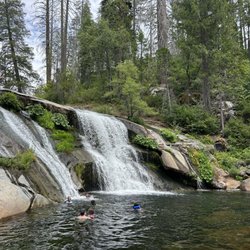
    Carlon Falls Trail is one of the most rewarding hikes because at the end, there is a beautiful…read morewaterfall and cold pool of water to swim in. The hike is about 3 miles and starts off in Groveland, in Stanislaus National Forest, and goes into Yosemite National Park. You will have to go on a dirt trail and go up and down a couple of rocky hills so make sure to wear good hiking shoes. There are spots along the river that you can stop at if you don't want to hike all the way to the end. But it's worth it to go to the end. There are waterfalls (not super tall), but very pretty, especially with the surrounding trees and nature. In the summer, when the temperature is hot, the water is very refreshing, but it is very cold. A lot of people enjoy swimming in the waters at Carlon Falls. Not only is this one of the prettiest hikes in Yosemite, it's free to hike this trail. Also, if you park your car up the road, the parking would be free too. I've done this hike 3 times in the past 4 years and have enjoyed it each time.

    Really beautiful river trail that ends at a spectacular waterfall, not too far from Hetch Hetchy…read more Carlon falls trail begins outside the Carlon Day Use area with a small roadside lot. If it's full, you can park, for a fee, in the day use area. That's $10, cash only. There was a remarkably clean pit toilet as well as some picnic areas in the day use area. The trail itself is easy to navigate and only goes one direction along the river and to the falls. It's mostly flat and well shaded, until the end when you have to scramble up a rocky hillside. In May 2023, the cascades prior to the falls are running pretty intensely as were the falls. The surrounding forest was a bit gloomy as it's recovering from the Rim Fire. Still, the tall trees, new growth and some pops of wildflowers made for a fun hike. You also get some lovely river views. My fitness tracker put it at almost 3.5 miles. Nice little side trip when in the area and don't want to go from Hetch Hetchy down to Yosemite valley but still want to get some miles in.

    Photos
    Carlon Falls Trail - Downstream from Carlon Falls

    Downstream from Carlon Falls

    Carlon Falls Trail - Downstream from the falls

    Downstream from the falls

    Carlon Falls Trail - Carlon Falls

    See all

    Carlon Falls

    Ostrander Lake - Beautiful alpine lake

    Ostrander Lake

    5.0(6 reviews)
    151.9 mi

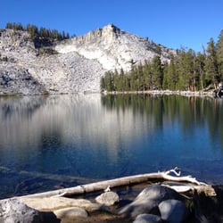
    I didn't swim here, and that's a tragedy. Oh, it was a conscious choice. My hiking partner sure…read moredid, but I had just made the 6-plus mile hike up 1500 feet and was ready for a snack, which turned into a photo stop, which turned into some great shots of the scenery, the lake, the ski hut, and the incredible granite cliffs through the haze of wildfire smoke. So I still had a great visit, but I didn't swim. Not that I didn't swim in any alpine lakes on this trip. Don't worry, I made up for it the next morning. But if I go to Ostrander again, you best believe we're going to stand on the shore, take a deep breath, and jump in those icy waters. It's so so refreshing! It's life! It's living! It's being IN nature and letting the water surround you, and for a brief moment being a part of that ecosystem. There are two trailheads that make the most sense to reach here. Ostrander Lake is the obvious choice, but you could start from Buena Vista and it wouldn't add a ton of distance. But since Glacier Point Road is on a shuttle, it probably doesn't really matter if you just hop on and head up to the Ostrander Lake Trailhead proper. The trail is very lovely. It starts at 7000ft and wanders through some meadowy terrain for a while, and then you get to the little creek and trail fork. From there, you're going to go up. The views are stellar. But let's just talk about this lake some more, shall we? This is not Yosemite Falls. This is not Half Dome, or El Cap. This is very much an off the beaten path adventure, and while I was on the entire hike I only saw maybe a half dozen other parties. At the lake, there was a family there when we arrived, but after a short time, we had the entire thing to ourselves. It was getting a little later in the day (maybe 4pm) and we were pressing on a little to find a place to camp. You can reach the lake as a day hike, but I think it makes a spectacular backpaking destination. Cross-country skiers love this lake, too. In the winter, you can ski in and rent the ski cabin. It's very spartan, but does have a wood fire stove, and fresh water (that needs to be filtered) that comes in from the lake. I don't ski, but I do wonder if you could reach it snow shoeing. They say that it's not for the faint of heart, but just think of that adventure! To come to the snowy, iced over lake and stay in the old stone cabin, look out the windows from the warmth of an historic building, over the vast Yosemite wilderness. Let's put that on the hope and dream list, ya? And then let's take the steps (literally and figuratively) to make it happen! My summer visit, though, was really special. The scenery here is incredible, and you can look up at the massive granite cliffs that surround the back half of the lake and just be boggled at the scale of it all. I'm so glad I took the time to get out of the valley and see this obscure but gorgeous scene. I just wish I would have gone swimming. Let's add it to the list!

    Cannot recommend enough! It was a long one and pieces of the hike did require a bit of effort with…read morethe elevation gain but, worth every step. Highly recommend during the late spring or early summer. The flowers are stunning that time of year.

    Photos
    Ostrander Lake - Sunset on the lake

    Sunset on the lake

    Ostrander Lake - Stone House by the Lake, almost fairytale like.  One might expect to greet Snow White and the 7 Dwarfs at dawn.

    See all

    Stone House by the Lake, almost fairytale like. One might expect to greet Snow White and the 7 Dwarfs at dawn.

    Mariposa Grove of Giant Sequoias - 2025 May 12: Mariposa Grove Perimeter Trail and Biledo Meadow Trail

    Mariposa Grove of Giant Sequoias

    4.4(131 reviews)
    145.8 mi

    We love this place! We always stop here to walk the trails amongst the giant Sequoias…read more You need to park and take a shuttle to the Grove. The shuttle runs pretty frequently so the wait isn't very long but the line can get long during the weekends. We like to go early in the day when it's not so busy. The main loop has a wide wooden boardwalk. The trails are well maintained and busy. There are restrooms at the start and benches along the main loop. Highly recommend.

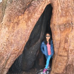
    Firstly, if this is a must see, be sure and ask the ranger for a pocket trail map when you drive…read morein. The ranger handed us one when we arrived at the Wawona Gate and told her we hoped to find parking at Mariposa, since the weekend proved too crowded (folks were parking along the main road and walking uphill to the Welcome Plaza, something that would have been too much of a challenge for us in the midday sun). She assured us it was much less crowded this Monday morning, and handed us the pocket map, which became very helpful, once I remembered it was actually IN MY POCKET! This is the first time I've been able to see this grove of Giant Sequoias in Yosemite. It reopened in June 2018 after a long closure and refurbishment to allow better access while protecting the trees in their ideal conditions - meaning, keep humans at bay. When you arrive at Mariposa Grove Welcome Plaza, there are nice bathrooms and a small bookstore, sundries, souvenir shop and information about the various hikes, maps of trails(I suggest taking a pic of, if you don't have the pocket map), and volunteers happy to guide you through hiking options, or easy routes to just see the largest of the popular Sequoias, Grizzly Giant. You catch the shuttle here for the 6 mins ride to the trailhead for Mariposa Grove, Big Tree Loop and Grizzly Giant Loop trails. We opted for the "moderate" hike along the Mariposa Grove Trail to Tunnel Tree, in which we saw the famous Grizzly Giant as well as the notable Bachelor and Three Graces trees. Our elevation gain was about 300ft. We then continued .2 miles to Tunnel Tree. After queuing for our turn to take pics, we added on treks to see Faithful Couple and Clothespin trees and still found it mildly challenging, but not strenuous. I believe we hiked a total of 1.25 miles up, then it was all an easy downhill back. This total visit, with shuttle rides up and back, took 3 hours. We did not find this to be "moderate," but rather enjoyable and only slightly more challenging than a level walk around a forest. My friend often has to stop periodically for heart rest breaks when hiking, but didn't need any breaks on during today's hike. Take plenty of drinking water with you and maybe a light snack. If you need a restroom, try holding out for the ones at the Welcome Center. The set up at the shuttle pickup/drop-off were not as well maintained, lacked TP, had on stall marked "Closed for the Season," like THAT would be a thing, and defunct hand dryers, but no paper towels. All in all, if you're a fan of Giant Sequoias, you'll want to add Mariposa Grove to your list. We are hitting all the Giant Sequoia areas we can during this road trip, so I would say, comparing the 2 so far, Calaveras Big Trees Park was more enjoyable and an easier tour of these amazing Goliaths, but soon we will add Sequoia Ntl Park & Kings Cyn, so THEN we will know definitively which park towers above the rest. Cheers! "CC"

    Photos
    Mariposa Grove of Giant Sequoias - 2025 May 12: Mariposa Grove Perimeter Trail and Biledo Meadow Trail

    2025 May 12: Mariposa Grove Perimeter Trail and Biledo Meadow Trail

    Mariposa Grove of Giant Sequoias
    Mariposa Grove of Giant Sequoias

    See all

    Chilnualna Falls Trail - Chilnualna Falls Trailhead, Yosemite National Park: 2026 Jul 29

    Chilnualna Falls Trail

    4.6(18 reviews)
    148.8 mi

    Chilnualna Falls Trailhead, Yosemite National Park: 2026 Jul 29 (4.75 of 5)…read more Chilnualna Falls: Strenuous but Worth the Pain (9.23 mi) Chilnualna Falls is my favourite hike in Yosemite. Even before you begin your hike, the sounds of rushing water welcome you. Stay awhile and enjoy the mist before you climb the rock steps. The climb up Chilnualna Falls is strenuous and steep, with continuous uphill climbing and several switchbacks. In some areas you'll hear the waterfall but not see one. If you feel like challenging yourself, continue climbing to the top. Every time I reach the top, I want to stay awhile -- maybe because I'm too tired to climb back down... but also because reaching the top of Chilnualna Falls is not mere accomplishment, it's an exhilarating feeling. You'd want to stay and enjoy the sounds of water rushing below you. The water sliding over granite drops 240-feet down and is a sight to behold. Wear comfortable hiking shoes and cotton socks. Dress in layers. Wear a hat and sunglasses. Tips and What to Bring: 1) Start early. Preferably before 6:30 am. 2) Bring plenty of water: More than you think you need. Dehydration sets in pretty quickly. 3) Pack emergency items just in case. 4) Pack a light lunch. 5) Rubbish bags (take out what you bring in) 6) Horn (to scare wild animals away) 7) Sunscreen

    This review is for Chilnualna Falls Trail which was a ~7.7 miles round trip that took ~6 hours to…read morecomplete in the snow. Chilnualna Falls Trail was located near the south entrance of Yosemite National Park; away from the busy Yosemite Valley. Lower Chilnualna Fall was a short ~0.2 miles and gets crowded at this particular spot. For the most part, the trail was a steady incline on dirt and rock with snow at higher elevations. In addition, there were a few downed trees over the trail. Overall, stunning views throughout this hike! There was a ~3 minute walk from the parking to the trailhead. Restrooms available at the parking area. Short video of the hike for those interested! https://youtu.be/jACscCHBcOg

    Photos
    Chilnualna Falls Trail - View from the trail

    View from the trail

    Chilnualna Falls Trail - 2025 Apr 29: Chilnualna Falls

    2025 Apr 29: Chilnualna Falls

    Chilnualna Falls Trail

    See all

    Remmington Trail - hiking - Updated October 2026

    Loading...
    Loading...
    Loading...