Swinging Bridge Trail Photos
 - Hiking Near Me - Fish Camp, California")
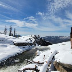
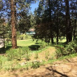
 along the trail! (June 2025) - Hiking Near Me - Fish Camp, California")

 - Hiking Near Me - Fish Camp, California")
More like Swinging Bridge Trail
Recommended Reviews - Swinging Bridge Trail
Start your review...

Superb little picnic and frolic spot near Wawona - ideal for young families. Visited a couple of times when we were staying at the Redwoods (vacation rental) nearby. The walk from the parking lot is an easy half-mile through the trees, and then you have to make your way to the swinging bridge and down to the water and the rocks. Walking across the swinging bridge (which we did one at a time) was my favorite experience, followed by swimming in the water below. The early am visit was much more pleasant, later in the day it gets hot and there isn't much shade down near the water. We all had a blast, and will surely return! read more

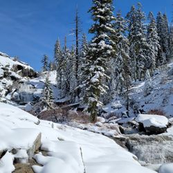
 end of Yosemite National Park. - Hiking Near Me - Fish Camp, California")
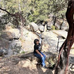
 was my favorite experience. - Hiking Near Me - Fish Camp, California")


2 years ago
Parking is free was lots of empty spot .Hike is like a mile depends on your speed was fun we get to see the river water flow, bird chipping, butterflies and also lizards the swinging bridge was nice took lots of pictures .Fun for all ages. Must visit place!! read more

This place is magical! Imagine a short hike that takes you into an area with wildflowers, beautiful pines and a running river. Imagine crossing a swinging bridge, walking along the trail, climbing down some rocks and swimming in a crystal clear river. If you can see it in your minds eye, then go experience this area, it's gorgeous! Remember your sunscreen, lots of water and towels. The granite rocks can be slippery when wet so be careful close to the water. And enjoy, this is the place dreams are made of! read more


5 years ago
We wanted to do something easy and chill, so my friend picked this trail and off we went. It was pretty easy to find, plenty of parking and for a minute once you got walking you did wonder if you were still going the right way or not, but then we saw the sign and knew we were good, it was sad to see all the burned trees around but the view at the end was beautiful, we ate our lunches on the rocks and enjoyed the peace and then made our way back. There was another trail there too that seemed longer and more intense, so you have choices. read more


3 years ago
More info about Swinging Bridge Trail
8266 Wawona Rd
Fish Camp, CA 93623
Directions
Hours
Outdoor Amenities


Swinging Bridge Trail - hiking - Updated June 2026
Best of Fish Camp
People found Swinging Bridge Trail by searching for…
Things to Do in Fish Camp, California
Beaches in Fish Camp, California
Hiking Trails in Fish Camp, California
Parks in Fish Camp, California
River Swimming in Fish Camp, California
Swimming in Fish Camp, California
Picnic Areas in Fish Camp, California
Walking Trails in Fish Camp, California
Redwood Trees in Fish Camp, California
Running Trails in Fish Camp, California
Scenic View in Fish Camp, California
Picnic Spots in Fish Camp, California
Scenic Overlook in Fish Camp, California
Easy Hikes in Fish Camp, California
Bridge in Fish Camp, California
Playgrounds in Fish Camp, California
Swimming Lakes in Fish Camp, California
Free Parking in Fish Camp, California
Trail in Fish Camp, California
Lookout Points in Fish Camp, California
Swimming Holes in Fish Camp, California
Trending Searches in Fish Camp, CA
4th Of July Fireworks near Swinging Bridge Trail
Boat Rental near Swinging Bridge Trail
Cliff Jumping near Swinging Bridge Trail
Fireworks near Swinging Bridge Trail
Fishing Spots near Swinging Bridge Trail
Fruit Picking near Swinging Bridge Trail
Kayak Rental near Swinging Bridge Trail
Lakes & Ponds near Swinging Bridge Trail
Public Pools near Swinging Bridge Trail
Public Shower near Swinging Bridge Trail
River Tubing near Swinging Bridge Trail
Scenic Overlook near Swinging Bridge Trail
Splash Pad near Swinging Bridge Trail
Strawberry Picking near Swinging Bridge Trail
Sunrise View near Swinging Bridge Trail
Swimming Holes near Swinging Bridge Trail
Swimming Lakes near Swinging Bridge Trail
U Pick Farms near Swinging Bridge Trail
Browse Articles
Browse Nearby
BEST of Fish Camp, California Restaurants near Swinging Bridge Trail
BEST of Fish Camp, California Coffee near Swinging Bridge Trail
BEST of Fish Camp, California Lakes near Swinging Bridge Trail
BEST of Fish Camp, California Things to Do near Swinging Bridge Trail
BEST of Fish Camp, California Hot Springs near Swinging Bridge Trail
BEST of Fish Camp, California Picnic Areas near Swinging Bridge Trail
BEST of Fish Camp, California Breakfast near Swinging Bridge Trail
BEST of Fish Camp, California Campgrounds near Swinging Bridge Trail
BEST of Fish Camp, California Visitor Centers near Swinging Bridge Trail
Browse Brands
Related Searches in Fish Camp, CA
Affordable Jet Ski Rental Options in Fish Camp, California
Affordable Kayak Rental Services in Fish Camp, California
Best Fishing Locations and Guides in Fish Camp, California
Best Places for Horseback Riding in Fish Camp, California
Best Sledding Spots and Fun in Fish Camp, California
Best Spots for Star Gazing in Fish Camp, California
Best Waterfalls and Swimming Holes in Fish Camp, California
Check Out Off Road Trails in Fish Camp, California
Discover Dog Friendly Trails to Explore in Fish Camp, California
Discover Scenic Mountain Bike Trails Near Fish Camp, California
Discover a Hiking Trail in Fish Camp, California
Discover the Best Night Hike Trails in Fish Camp, California
Enjoy Camping Adventures Around Fish Camp, California
Enjoy Exciting Mountain Biking Adventures in Fish Camp, California
Enjoy Kayaking Adventures in Fish Camp, California
Enjoy Tent Camping Spots Around Fish Camp, California
Enjoy a Beautiful Waterfall Hike in Fish Camp, California
Enjoy the Best Tubing Experiences in Fish Camp, California
Exciting Cliff Jumping Spots in Fish Camp, California
Experience Stunning Sunset Views in Fish Camp, California
Experience Thrilling White Water Rafting in Fish Camp, California
Explore Beautiful Parks and Green Spaces in Fish Camp, California
Explore Bike Rentals Throughout Fish Camp, California
Explore Easy Hikes Perfect for All in Fish Camp, California
Explore Fun Activities to Do in Fish Camp, California
Explore Popular Campgrounds Near Fish Camp, California
Explore Popular RV Parks Around Fish Camp, California
Explore Popular Scenic Overlook Points in Fish Camp, California
Explore Scenic Lakes to Visit in Fish Camp, California
Explore the Best Boating Spots in Fish Camp, California
Explore the Best Swimming Holes Around Fish Camp, California
Explore the Best Trail Options in Fish Camp, California
Explore the Scenic River in Fish Camp, California
Family Friendly Hiking With Kids in Fish Camp, California
Find the Best Playgrounds to Visit in Fish Camp, California
Find the Best Scenic View Locations in Fish Camp, California
Must-See Tourist Attractions Around Fish Camp, California
Off Leash Dog Hiking Trails in Fish Camp, California
Plan a Scenic Drive Route Near Fish Camp, California
Popular Kids Activities in Fish Camp, California
Popular Outdoor Activities to Try in Fish Camp, California
Popular Things to Do in Fish Camp, California
Popular Things to See in Fish Camp, California
Relax at Natural Hot Springs Near Fish Camp, California
Safe and Fun Parks for Kids in Fish Camp, California
Top Climbing Spots and Gyms in Fish Camp, California
Top Swimming Lakes to Enjoy in Fish Camp, California
Top Swimming Spots and Pools in Fish Camp, California