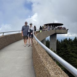
Hiwassee Dam Photos


More like Hiwassee Dam
Recommended Reviews - Hiwassee Dam
Start your review...

1 year ago
The Hiwassee Dam is a little bit of a detour from Murphy, NC. But I highly recommend a stop. The dam is hydroelectric and is remarkable to see just the size of it. You can drive over it too. I wasn't sure at the time if I could take a walk on it so I behaved myself this time. There appeared to be sidewalks on both sides in sections so I will do that next time. The dam is 307 feet high and holds 67 billion gallons of water. Hiwassee Lake is about 22 miles. The dam took 1600 men four years to build before being completed in 1940. At the time it cost $24 million to build. The dam generates enough electricity for 28,000 homes. The views are breathtaking here so if you are in the area this remarkable piece of work. read more


8 years ago
If you're in the Murphy area, or planning a trip out to the falls, and enjoy being outdoors, be sure to take a quick detour and venture into easily accessible Hiwassee. Surrounded by the Nantahala and Cherokee National Forests - This cozy and colorful park has a lot to offer, including a rich habitat for deer, wild turkey and other animals. Have your camera ready to snap memorable moments, scenery and wildlife. Built in the 1940's, the Hiwassee Dam is largely known to locals as 1 of 32 dams built & planned to provide flood control, navigation and electricity for the region. Today, this piece of history is known as one of the top 5 things to do/points of interest for those visiting Murphy. Upstream from Apalachia Reservoir, the river stretches for 22 miles northwest to southeast. The Pros: - Great for picnics. - Free and easy to locate parking. - The area features a day-use park that provides access to boating, fishing and paths for exploring the Hiwassee Reservoir and its tributaries. - The area is isolated and not overloaded with people/tourists (even during season). On most occasions you will find yourself alone and have this stunning area all to yourself. It's well suited for canoeing & rafting. - The dam is close to Cherokee, the falls and many of Murphy's other "must-see" areas. Prior to your trip, consider these tips: - Check out & research the weather conditions prior to making your plans to venture out onto the roads, or into the water. The reservoir comes from deep below the surface and the water temperature is super chilly, even in the summer. - Keep an eye out for snakes! - If it's summer, be sure to pack bug spray and sun screen. Fun Facts: - The dam is known as a historical landmark used by the Navy Bureau of Ordnance for torpedo testing into the deep water, and the isolation provided by its mountainous environs. - The dam is currently operational and still providing electricity today. read more


4 years ago
More info about Hiwassee Dam


Hiwassee Dam - landmarks - Updated June 2026
Best of Murphy
People found Hiwassee Dam by searching for…
Things to Do in Murphy, North Carolina
Parks in Murphy, North Carolina
Scenic Views in Murphy, North Carolina
Scenic Overlook in Murphy, North Carolina
Picnic Areas in Murphy, North Carolina
Attractions in Murphy, North Carolina
Scenic Drive in Murphy, North Carolina
Historical Sites in Murphy, North Carolina
Photo Spots in Murphy, North Carolina
Tourist Attractions in Murphy, North Carolina
Landmarks in Murphy, North Carolina
Sightseeing in Murphy, North Carolina
View Points in Murphy, North Carolina
Places to Take Pictures in Murphy, North Carolina
Tourist in Murphy, North Carolina
Night View in Murphy, North Carolina
Scenic Restaurants in Murphy, North Carolina
Waterfront in Murphy, North Carolina
Picnic Parks in Murphy, North Carolina
Beautiful Views in Murphy, North Carolina
Waterfalls in Murphy, North Carolina
Hiking Trails in Murphy, North Carolina
Trending Searches in Murphy, NC
Cliff Jumping near Hiwassee Dam
Fishing Spots near Hiwassee Dam
Historical Sites near Hiwassee Dam
Jet Ski Rental near Hiwassee Dam
Kayak Rental near Hiwassee Dam
Landmarks & Historical Buildings near Hiwassee Dam
Lookout Points near Hiwassee Dam
Places To Visit near Hiwassee Dam
Public Pools near Hiwassee Dam
River Swimming near Hiwassee Dam
River Tubing near Hiwassee Dam
Scenic Restaurants near Hiwassee Dam
Strawberry Picking near Hiwassee Dam
Swimming Holes near Hiwassee Dam
Swimming Lakes near Hiwassee Dam
Things To See near Hiwassee Dam
Browse Articles
Browse Nearby
Browse Brands
Related Searches in Murphy, NC
Best Fun Things to Do in Murphy, North Carolina
Best Nature Trails for Hiking in Murphy, North Carolina
Best Things to Do on a Rainy Day in Murphy, North Carolina
Best Waterfalls and Swimming Holes in Murphy, North Carolina
Book Engaging Historical Tours in Murphy, North Carolina
Discover Charming Historic Homes in Murphy, North Carolina
Discover Historic Sites and Places in Murphy, North Carolina
Discover Popular Landmarks in Murphy, North Carolina
Discover Popular Photo Spots in Murphy, North Carolina
Discover the Best Caves to Explore in Murphy, North Carolina
Discover the Best Planetarium Shows in Murphy, North Carolina
Enjoy Arts & Entertainment in Murphy, North Carolina
Enjoy Hiking Adventures in Murphy, North Carolina
Enjoy the Best Walking Trails in Murphy, North Carolina
Experience Stunning Sunset Views in Murphy, North Carolina
Explore Beautiful Botanical Gardens in Murphy, North Carolina
Explore Beautiful Castles and Landmarks in Murphy, North Carolina
Explore Beautiful Parks and Green Spaces in Murphy, North Carolina
Explore Children's Museums Near Murphy, North Carolina
Explore Easy Hikes Perfect for All in Murphy, North Carolina
Explore Family-Friendly Zoos and Wildlife in Murphy, North Carolina
Explore Free Things to Do Around Murphy, North Carolina
Explore Fun Activities to Do in Murphy, North Carolina
Explore Fun Field Trips in Murphy, North Carolina
Explore Popular Scenic Overlook Points in Murphy, North Carolina
Explore Popular Scenic Views Near Murphy, North Carolina
Explore Secret Spots Worth Visiting in Murphy, North Carolina
Explore Top Art Galleries Located in Murphy, North Carolina
Explore Venues & Event Spaces in Murphy, North Carolina
Find Beautiful Views in Murphy, North Carolina
Find Top-Rated Waterfalls in Murphy, North Carolina Now
Find the Best Playgrounds to Visit in Murphy, North Carolina
Fun Rainy Day Activities to Try in Murphy, North Carolina
Hiking Trails With Waterfalls in Murphy, North Carolina
Must-See Tourist Attractions Around Murphy, North Carolina
Perfect Spots to Watch Sunset in Murphy, North Carolina
Popular Kids Activities in Murphy, North Carolina
Popular Picnic Spots to Visit in Murphy, North Carolina
Popular Places to Take Pictures in Murphy, North Carolina
Popular Things to Do in Murphy, North Carolina
Popular Things to See in Murphy, North Carolina
Public Services & Government Offices in Murphy, North Carolina
Top Entertainment Options in Murphy, North Carolina
Top Hiking Trails to Explore in Murphy, North Carolina
Top Places to Visit in Murphy, North Carolina for Sightseeing
Top Things to Do With Kids in Murphy, North Carolina
Tour Famous Lighthouses Located in Murphy, North Carolina
Tour Popular Historical Sites in Murphy, North Carolina
People who viewed Hiwassee Dam also viewed
Bell Mountain
59 reviews
Brasstown Bald Observation Tower
78 reviews
Andrews Rest Area
5 reviews
City of Blairsville, GA
2 reviews
Brasstown Bald
1 review
Union County HIstorical Society
1 review
Caboose Visitor Center Fannin County Chamber of Commerce
1 review
Historic Downtown Murphy
1 review
Granny Squirrel Covered Bridge
1 review
Thomas Samuel Ashe
1 review