Andrews Rest Area Photos


More like Andrews Rest Area
Recommended Reviews - Andrews Rest Area
Start your review...

11 months ago
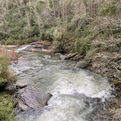
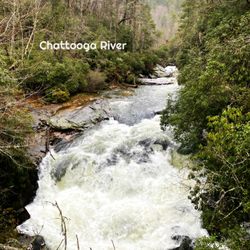
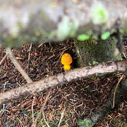
The Cherokee County Rest Stop in Andrews, NC is well worth a stop just to take a little break from the mountain roads. The parking lot is a good size. The landscaping is well kept. I've not seen a rest stop as nice as this one. The restrooms were clean. The picnic tables are in the shade. Best of all you can either go down to the river or enjoy the views from the porch. It appeared very accessible for those with any mobility issues. There is signage about the Trail of Tears to read as well. Check out this rest stop for the scenery and the history. read more


6 months ago
We love this rest stop, it always clean, but it's also such a tranquil, peaceful area with a lovely creek running through it. Be sure to visit the deck out back overlooking it and enjoy a few serene minutes on your journey. read more


8 months ago
4 years ago
Beautiful place to stop and eat, relax and listen to the river. It has historical significance as a spot on the Trail of Tears. If you like history make this a stop along your journey. I am not regretting it at all. It is VERY wheelchair friendly and has allowed my husband to get around and take pictures. All In All it will be a stop off rest area I will continue to stop at when I travel through North Carolina. read more


4 years ago
More info about Andrews Rest Area


Why does Yelp recommend reviews?
1 review that is not currently recommended
The reviews below are not factored into the business's overall star rating.
2 years ago
Andrews Rest Area - landmarks - Updated May 2026
Best of Andrews
People found Andrews Rest Area by searching for…
Things to Do in Andrews, North Carolina
Watch Sunset in Andrews, North Carolina
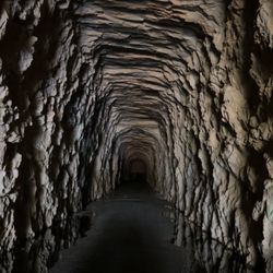
Caves in Andrews, North Carolina
Sunset View in Andrews, North Carolina
Gold Panning in Andrews, North Carolina
Scenic Overlook in Andrews, North Carolina
Places to Take Pictures in Andrews, North Carolina
Hiking Trails With Waterfalls in Andrews, North Carolina
Scenic Drive in Andrews, North Carolina
Historical Tours in Andrews, North Carolina
Sunrise View in Andrews, North Carolina
Scenic Views in Andrews, North Carolina
Public Services & Government in Andrews, North Carolina
Parking in Andrews, North Carolina
Plantation Tours in Andrews, North Carolina
Historical Sites in Andrews, North Carolina
Photo Spots in Andrews, North Carolina
Waterfalls in Andrews, North Carolina
Public Parking in Andrews, North Carolina
Night View in Andrews, North Carolina
Bridge in Andrews, North Carolina
Landmarks in Andrews, North Carolina
Trending Searches in Andrews, NC
Botanical Gardens near Andrews Rest Area
Bounce House Rentals near Andrews Rest Area
Campgrounds near Andrews Rest Area
Cliff Jumping near Andrews Rest Area
Floral Designers near Andrews Rest Area
Gold Panning near Andrews Rest Area
Golf Lessons near Andrews Rest Area
Historical Sites near Andrews Rest Area
Landmarks & Historical Buildings near Andrews Rest Area
Lookout Points near Andrews Rest Area
Nurseries & Gardening near Andrews Rest Area
Outdoor Furniture Stores near Andrews Rest Area
Party Equipment Rentals near Andrews Rest Area
Pedicure near Andrews Rest Area
Photo Spots near Andrews Rest Area
Places To Take Pictures near Andrews Rest Area
Plant Nursery near Andrews Rest Area
Public Services & Government near Andrews Rest Area
Browse Articles
Browse Nearby
BEST of Andrews, North Carolina Photo Spots near Andrews Rest Area
BEST of Andrews, North Carolina Coffee near Andrews Rest Area
BEST of Andrews, North Carolina Things to Do near Andrews Rest Area
BEST of Andrews, North Carolina Parks near Andrews Rest Area
BEST of Andrews, North Carolina Restaurants near Andrews Rest Area
BEST of Andrews, North Carolina Campgrounds near Andrews Rest Area
BEST of Andrews, North Carolina Hotels near Andrews Rest Area
BEST of Andrews, North Carolina Breakfast near Andrews Rest Area
BEST of Andrews, North Carolina Star Gazing near Andrews Rest Area
Browse Brands
Related Searches in Andrews, NC
Best Fishing Locations and Guides in Andrews, North Carolina
Best Fun Things to Do in Andrews, North Carolina
Best Lookout Points to Visit in Andrews, North Carolina
Best Observation Deck Views in Andrews, North Carolina
Best Spots for Star Gazing in Andrews, North Carolina
Best Things to Do on a Rainy Day in Andrews, North Carolina
Best Waterfalls and Swimming Holes in Andrews, North Carolina
Discover Charming Historic Homes in Andrews, North Carolina
Discover Family-Friendly Aquariums in Andrews, North Carolina
Discover Famous Monuments in Andrews, North Carolina
Discover Fun Kid Activities in Andrews, North Carolina, {State}
Discover Popular Photo Spots in Andrews, North Carolina
Discover Stunning Skyline View Spots in Andrews, North Carolina
Discover the Best Beaches in Andrews, North Carolina
Discover the Best Caves to Explore in Andrews, North Carolina
Discover the Best Planetarium Shows in Andrews, North Carolina
Enjoy Arts & Entertainment in Andrews, North Carolina
Enjoy Hiking Adventures in Andrews, North Carolina
Experience Stunning Sunset Views in Andrews, North Carolina
Explore Beautiful Botanical Gardens in Andrews, North Carolina
Explore Beautiful Castles and Landmarks in Andrews, North Carolina
Explore Beautiful Parks and Green Spaces in Andrews, North Carolina
Explore Family-Friendly Zoos and Wildlife in Andrews, North Carolina
Explore Free Things to Do Around Andrews, North Carolina
Explore Fun Activities to Do in Andrews, North Carolina
Explore Fun Field Trips in Andrews, North Carolina
Explore Popular Scenic Overlook Points in Andrews, North Carolina
Explore Popular Scenic Views Near Andrews, North Carolina
Explore Scenic Lakes to Visit in Andrews, North Carolina
Explore Secret Spots Worth Visiting in Andrews, North Carolina
Explore Venues & Event Spaces in Andrews, North Carolina
Find Exciting Tours to Take in Andrews, North Carolina
Find Top Libraries to Visit in Andrews, North Carolina
Find Top-Rated Waterfalls in Andrews, North Carolina Now
Find the Best Bridge Spots in Andrews, North Carolina
Find the Best Playgrounds to Visit in Andrews, North Carolina
Fun Rainy Day Activities to Try in Andrews, North Carolina
Hiking Trails With Waterfalls in Andrews, North Carolina
Must-See Tourist Attractions Around Andrews, North Carolina
Perfect Spots to Watch Sunset in Andrews, North Carolina
Popular Kids Activities in Andrews, North Carolina
Popular Picnic Spots to Visit in Andrews, North Carolina
Popular Places to Take Pictures in Andrews, North Carolina
Popular Things to Do in Andrews, North Carolina
Secure Convenient Parking Options in Andrews, North Carolina
See Top Fireworks Events in Andrews, North Carolina
Top Entertainment Options in Andrews, North Carolina
Top Hiking Trails to Explore in Andrews, North Carolina
People who viewed Andrews Rest Area also viewed
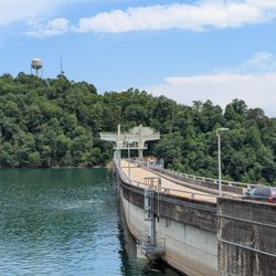
Hiwassee Dam
3 reviews
Fontana Dam
10 reviews
Road to Nowhere
5 reviews
Telliquah Covered Bridge
2 reviews
Cherokee Indian Reservation
2 reviews
Historic Downtown Murphy
1 review
Cherokee Defeat Historical Marker
1 review
Fontana Regional Library System - Macon County Public Library
1 review
Swain County Heritage Museum
9 reviews
Bryson City Town Office
4 reviews