Cancel

    Open app

    Search

    Hellhole Canyon Trail

    4.6 (11 reviews)

    Hellhole Canyon Trail Photos
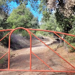
    You might also consider

    Recommended Reviews - Hellhole Canyon Trail

    Your trust is our priority, so businesses can't pay to alter or remove their reviews. Learn more about reviews.
    Yelp app icon
    Browse more easily on the app
    Review Feed Illustration

    Reviews With Photos

    This is me during the desert bloom.  I went to see the bloom three times, in Jan.-Feb. 2019. - - - Tom Brody
    Tom B.

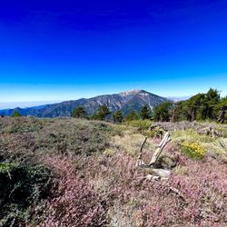
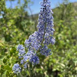
    Hellhole Canyon in Anza Borrego Desert State Park, is located on Montezuma Valley Road, about 1,000 feet south of the entrance to the State Park Visitor Center. A large parking lot is located next to Montezuma Valley Road, and from there you need to take a one mile hike to the point where Hellhole Canyon narrows to a width of about 200 feet. From this narrowing point, Hellhole Palms and Maidenhair Falls are reacehd after walking another 4,500 feet. CARPETS OF PINK, WHITE, VIOLET, YELLOW, AND BLUE. During the desert bloom occurring in February and March, I visited Hellhole Canyon, Glorietta Canyon, Coyote Canyon, Henderson Canyon, and Yaqui Pass, and took photographs of the flowers in each each of these places. Each of these visits was on a weekday (not on Saturday or Sunday), and I skipped work in order to avoid the traffic and the crowds that occur during the annual desert bloom. My posted photographs show sand verbena (colored violet), California evening primrose (colored white), and annual wooly sunflower (the tall yellow-colored flower). Also, in the photograph showing me kneeling, a few ocotillo plants can be seen in the background. A guide for identifying flowers can be found at www dot borregoflowers dot com. GEOGRAPHY OF HELLHOLE CANYON. Pages 40, 56-57, 79-81, 85, and 90 from Geology of Anza-Borrego describe Hellhole Canyon. We learn that the lower slopes contain metasedimentary outliers. The sediment was deposited from 500 million years ago to 120 million years ago, and after that, pressure converted the sediment to shale, limestone, and quartz-rich sandstone. We learn that a large alluvial fan occurs at the mouth of Hellhole Canyon, and that this canyon is a cut within the San Ysidro Mountain escarpment, and that the oasis at Hellhole Palms was created by a fracture in rocks caused by an earthquake fault. RESTING WOMAN (looking like Nina Simone) IS VISIBLE FROM THE TRAIL LEADING TO HELLHOLE CANYON (but not adequately visible from areas that are much further to the north, south, east, or west). About one mile north of the State Park Visitor Center is a mountain range, and this mountain range is about six miles wide from north to south. From the Visitor Center, the angle of vision is not right for seeing the resting woman. But while walking from the parking lot at Hellhole Canyon towards the trailhead, then the angle of vision will be perfect for seeing the resting woman. On March 30, 2019, I posted my photograph of the resting woman on the BorregoBlooms Facebook page. Angela Carmen posted a comment, "Love the resting woman." I was amazed, because I had not noticed the resting woman until this comment was posted. I decided that she looked like Nina Simone. A year later, I read Geology of Anza-Borrego by Remeika and Lindsay, and learned that the correct name for this part of the mountain range that is just north of the Visitor Center, is INDIANHEAD PEAK (see, pages 4 and 78 of this book).

    Debbie H.

    First part is sandy trail with no shade but a large variety of beautiful dessert flowers. We saw lizards and a squirrel. It is easy to tell the trail. Once you get close to oasis / palms it is much harder to tell where to go.. have to go over boulders, cross the creek multiple times, try to figure your own way. The waterfall was lovely and refreshing once we got there. Wish there was some signage and markers to have an idea of how far you have gone and how much left to go. Did see a ton of tadpoles in creek and so many butterflies. Uphill on the way to falls, downhill on way down. 3 and 3/4 hours with about 15 minutes at falls.

    View from the ridge above the canyon looking at the Thimble

    See all

    7 years ago

    Helpful 5
    Thanks 0
    Love this 8
    Oh no 0
    Photo of Mel C.
    309
    1802
    12204

    7 years ago

    Helpful 14
    Thanks 0
    Love this 12
    Oh no 0

    7 years ago

    Helpful 0
    Thanks 0
    Love this 0
    Oh no 0

    6 years ago

    Helpful 0
    Thanks 0
    Love this 0
    Oh no 0

    4 years ago

    Helpful 2
    Thanks 0
    Love this 0
    Oh no 0
    Photo of Debbie H.
    8
    130
    43

    7 years ago

    Helpful 0
    Thanks 0
    Love this 0
    Oh no 0

    4 years ago

    Helpful 1
    Thanks 0
    Love this 0
    Oh no 0
    Photo of Mi W.
    72
    178
    133

    9 years ago

    Helpful 1
    Thanks 0
    Love this 1
    Oh no 0
    Photo of G H.
    40
    22
    0

    12 years ago

    Helpful 10
    Thanks 0
    Love this 6
    Oh no 0

    10 years ago

    Helpful 1
    Thanks 0
    Love this 2
    Oh no 0
    Photo of John T.
    144
    687
    2858

    8 years ago

    Helpful 3
    Thanks 0
    Love this 2
    Oh no 0

    Ask the Community - Hellhole Canyon Trail

    Review Highlights - Hellhole Canyon Trail

    From this narrowing point, Hellhole Palms and Maidenhair Falls are reacehd after walking another 4,500 feet.

    Mentioned in 6 reviews

    Read more highlights

    You might also consider

    Verify this business for free

    People searched for Hiking 250 times last month within 15 miles of this business.

    Verify this business

    Cedar Creek Falls - Cedar Creek Falls

    Cedar Creek Falls

    4.4(358 reviews)
    28.4 km

    If you are a San Diego hiker and haven't done this hike- WHAT ARE YOU WAITING FOR???…read more And for those of you who see these photos and think damn I need to go do that, please be aware of the temperature because it is dangerously hot down there at lower temperatures than in other areas. The hike goes down into a canyon and the heat settles down there. Even if it's not as hot as you think coming up can be extremely dangerous. Every year I hear about somebody dying from heat stroke on that hike so don't take it lightly. I always check the weather on the actual trail using the AllTrails app. I saw that the weather out there was max 65° that day and I was like hell yeah. The hike really isn't that difficult, 3 miles down and then 3 miles back up. Lots of nice switchbacks, and there are a few sun shelters for shade. The views are gorgeous all along the trail. I've done this hike, probably 20 times over the years. It's the best in the spring and in the fall. In the winter it's way too cold. The reward for this hike is the gorgeous rock bowl and waterfall that the locals call Devils Punchbowl. This past Thursday when we did this hike, there were a lot of young folks at the Punchbowl when we got there. Some of the guys were climbing up and jumping into the water. I would not recommend it, even if the waterfall is still flowing that water is not safe to swim in. In the fall, the waterfall doesn't flow anymore after being dried out over the brutal summer, but the trees at the bottom of the canyon turn a beautiful gold color. One of the few places in San Diego you can actually experience fall.

    Having lived in San Diego for so long, I honestly don't know why it took me this long to do this…read morehike. I finally got the permit online (definitely download it before you arrive since service can be spotty) and decided to go for it. I went in early May and started the trail around 8am, which turned out to be a great decision. The trail was practically empty at that time, and the downhill views were absolutely beautiful. I even saw two rattlesnakes before 9am, so definitely stay alert while hiking. At several points I had to remind myself I was still in San Diego and not somewhere in a huge national park. Once I got near the bottom, I did lose track of the trail a little and it was SOS, so having the AllTrails map downloaded beforehand was really helpful. It took me a little over an hour to reach the waterfall, and there were only two other people there at the time, which made it feel really peaceful and private. The water felt AMAZING after the hike down. There were so many fish in the water, and the whole area was honestly so pretty. By the time I started heading back around 10am, I noticed a lot more people arriving at the falls. The hike back up wasn't terrible, but the sun definitely makes it much harder on the return. I was very happy to make it back to the parking lot by around 11:30am. I would definitely bring lots of water, sunscreen, and some snacks.

    Photos
    Cedar Creek Falls - Cloud porn in the beginning of our hike!

    Cloud porn in the beginning of our hike!

    Cedar Creek Falls - Awesome day with one of my best girlfriends

    Awesome day with one of my best girlfriends

    Cedar Creek Falls - Morning frost

    See all

    Morning frost

    Volcan Mountain Preserve - Mountain Lion tracks

    Volcan Mountain Preserve

    4.6(87 reviews)
    12.4 km

    We tackled Volcan Mountain Trail with an eight-year-old, so we didn't make it the full way but it…read morewas such a nice experience. We also brought along our dog as it is a dog friendly trail as long as your dog is on a leash. The trail starts out pretty steep, but it's well-marked with clear paths throughout. One thing I really loved was all the signage explaining local plant life and animal tracks so it made the hike feel educational and engaging. My kiddo was really into looking at the different animal paw prints. This trail is great for hiking enthusiasts and beginners alike but just know your limits and pace yourself if you're newer to hiking. I would definitely say if it's sunny to make sure you bring plenty of water with you, but there are a lot of shady spots on this trail so that is a nice change from the hikes that are closer to coastal San Diego.

    It's a good hike to pair with a trip to Julian. My husband and I picked up sandwiches in town for a…read morepicnic on the trail. Parked next to the road and knew we were in the right place because of all the other cars. We made our hike a loop as we went up the mountain, taking the 5 Oaks Trail, and then came down using the Vulcan Mountain preserve trail. The 5 Oaks Trail has more of a view. There are a few seats to stop, sit (catch your breath) and enjoy the view. Sadly, we haven't had rain so it wasn't as green as I'm sure it would be on a normal January. Nevertheless, a great hike to work off all the apple pie you eat in Julian.

    Photos
    Volcan Mountain Preserve - Sign at the trailhead

    Sign at the trailhead

    Volcan Mountain Preserve
    Volcan Mountain Preserve

    See all

    Slot Canyon

    Slot Canyon

    4.7(83 reviews)
    28.3 km

    It's definitely a must do hike when you're visiting Anza borrego, Borrego springs or even Julian. I…read morewent here early May so it was extremely hot, even though I reached the trailhead around 9am. The drive to the parking lot was a little weird because after you get off the freeway, there is a dirt road for about 1.5-2 miles on which there were a lot of signs that said "no vehicles allowed" and "foot traffic only" so I wasn't sure if I should be driving. Once k got there, there were other cars parked too so my assumption is that those signs are applicable only during some seasons. The parking lot looks flat but you can see to trail once you start walking towards the canyon. The hike was really nice, it was definitely more of a walk rather than any uphills. It can get pretty hot so starting early in the summer can be advantageous.

    We decided to visit the Slot Canyon during our Borrego Spring trip. Although it doesn't compare to…read morethe slot canyon views in Arizona or Utah, it was picturesque. The slots were fairly easy to navigate except for a few areas where you had to climb down or squeeze through narrow openings. You can also take the trail above the canyon which gives you panoramic views of the desert. There are 2 bathrooms but no sinks in the parking lot. Most cars can get to the parking lot but it's quite dusty. Come prepared with some water, snack, sunscreen, hats, and sunglasses. It's $10 per day to visit the park. It's an honor system where you fill out the form, drop off the cash in box, and leave the parking pass on your dashboard. The one negative and reason for removing a star is the poor signage on the trail and how to get into the slots. When we went, there were only 2 other families but the signs were not clear which direction to go into the canyon or even back to the parking lot so we ended up taking a much longer and harder route than needed.

    Photos
    Slot Canyon
    Slot Canyon
    Slot Canyon - View point towards the end

    See all

    View point towards the end

    Hot Springs Mountain

    Hot Springs Mountain

    4.3(10 reviews)
    6.7 km

    My review is solely based on my hiking experience and not for the campground or other things here…read more I came here to summit Hot Springs Mountain as it's part of the San Diego Six Pack of Peaks challenge. Apparently it's the highest peak in San Diego as well. A fee of $10 is required. The trailhead is easy to find, just a little ways down after you pass the gate where the police vehicles are. The road is unpaved but is in fairly good condition, with no ruts or anything. Once you get to the restrooms the trailhead parking is to the left of it. There aren't really designated spots, you just need to park off of the road. The first 2 or so miles are in direct sunlight, and this is also where most of the elevation gain is. Once you get closer to the halfway point (around 2.4 miles) it's smooth sailing from there with just rolling hills and plateaus. You know you're almost there once you see the old lookout tower and reach the sign that points to the summit. Continue on this smaller trail and you'll reach the ladder and ropes to the summit. The summit can only fit a few people safely. I'm terrified of heights and sketchy things but still managed to do it. There are lots of bugs flying around on this trail. Other than that the trail is mainly a wide, well-maintained fire road. There's some forested areas you'll walk through, but nothing special. Good hike to get some elevation gain (2,200'+)! In total it took me 2 hours and 49 minutes (hiked up, ran down).

    You need to pay $10 for parking, either online or at the booth. The attendant on 2/4/24 was very…read morefriendly and informative regarding the hike conditions. The hike itself it roughly 10 miles round trip. Once you are past the first 2 miles, steady up, you will enjoy views in all directions and a beautiful walk through a forest. Snow was about 1-3 inches and melting fast. Trail is in a great condition, well marked. The fire tower is one of the oldest one, needs work so think twice before climbing it. The peak is a huge boulder to the right after following narrow paths for few hundred feet. If you feel adventurous you can climb the ladder to the top. From there you will have a nice view of the tower and neighboring peaks. Took me about 4 hours to complete.

    Photos
    Hot Springs Mountain - Me, at the Summit.

    Me, at the Summit.

    Hot Springs Mountain
    Hot Springs Mountain

    See all

    The Pacific Crest Trail - Views of Mt Baden-Powell from the trail!

    The Pacific Crest Trail

    4.8(6 reviews)
    44.1 km

    I always get really excited when I find a piece of the PCT lol! The PCT (or Pacific Crest Trail) is…read morepart of the coveted "Triple Crown of Hiking" title that very few hikers have achieved. The Triple Crown consists of the PCT, the Appalachian Trail and the Continental Divide Trail - the three longest north-to-south trails in the US. And to earn the title, you must do all three in their entirety! Now I know I'll never achieve that - and I'm well aware I won't ever even achieve doing just one of these - but I still get giddy doing a piece of them! So far I've done pieces of the PCT and the Appalachian- so two down, one to go haha! The PCT is 2653 miles long and runs from just south of Campo, California next to the border with Mexico all the way up to a spot on the Canada-US border. It passes through 25 national forests and 7 national parks! You can find pieces of it all over SoCal - too many spots to name here but if you look it up on Wiki it lists them all! Some of the more notable locations are at places like Vasquez Rocks, Anza-Borrego Desert State Park, Crystal Lake, and Big Bear. But my personal fave is just past the Blue Ridge Trail in Wrightwood (pictured in all my photos). Once you complete the Blue Ridge Trail, you'll find the PCT just past the campground - keep on it for another 1 - 1.5 miles and BOOM - you're hit with some incredible views of the back of the San Gabriel Mountains and some of its more iconic peaks such as San Antonio Peak and Mount Baden-Powell. I highly recommend using AllTrails and download the trail map bc signal is spotty here and you'll need it bc the PCT isn't obvious even though you'll find the iconic signs for photo ops in some spots. It does add another 1 to 1.5 miles to the hike and another 300+ feet in elevation gain to the already 1000+ feet of the Blue Ridge Trail. But you'll be over 8100 feet in the air at the top with amazing views and even lots of birds and wildflowers in September!! You may even get snow as far as into late April! This part of the PCT crosses the Blue Ridge Truck Trail - so you can actually drive up to this spot but it's not paved and is rocky and very bumpy so be aware. The hiking trail is well maintained. And the campground at the top has vault toilets (but no potable water). If you tie it in with the Blue Ridge Trail, you're looking at a total of 3 miles in and an elevation gain of over 1380+ feet (one way) - so 6 miles total. But it makes for a great morning - gorgeous views, tons of birds, hardly any other hikers during the week, lots of peace and quiet! One of my fave trails in the area! If you do this route, I'd call it a moderate and somewhat technical hike - definitely not for beginners. If you do it in the snow, it's hard and very technical (I've done both). But if you drive up and just do this tiny part of the PCT by itself it's pretty easy.

    Nice place to hike. Never made it to the top, its a 3 mile hike. Beautiful views. The trail is…read morekinda narrow, but i love hiking up there w my dog!

    Photos
    The Pacific Crest Trail - Views of the San Gabriel Mountains from the trail!

    Views of the San Gabriel Mountains from the trail!

    The Pacific Crest Trail - Views of Mt Baden-Powell from the trail!

    Views of Mt Baden-Powell from the trail!

    The Pacific Crest Trail - Views of Mt Baden-Powell from the trail!

    See all

    Views of Mt Baden-Powell from the trail!

    Inaja Memorial Park

    Inaja Memorial Park

    4.3(9 reviews)
    18.5 km

    I was curious to see this trail-park, but didn't know the history till I read the board, (which I…read moreterribly forgot to take a full photo of). It memorializes 11 men that died while digging a fire line on steep canyon - three Forest Service firefighters, seven inmates firefighters & their correctional officer (from the Viejas Honor Camp (prison camp), died at approximately 8:00 PM (part of the blaze looped below their position and overran the crew) The fire, (which was started by arson on November 24, 1956), burned 43,611 acres before containment on the evening of November 28. This is from the National Forest Service Library website. It's has quite a few picnic tables, a couple grills by them but I personally wouldn't want to bbq out there. There are restrooms that are like porta pottys and a short trail (trails) but I didn't walk too far because of my knee. It's a beautiful, peaceful & scenic spot to go to if you live in the area or if you want to add to a pit stop while venturing out here. Main Street in Julian is down from here where you can grab a bite to eat at anyone of the restaurants/cafes.

    A small picnic stop on the way up to Julian. We stopped by…read moreto check out the nature trail and its viewpoint of the Santa Ysabel valley. The small loop trail is only .5 miles and about 15 minutes of hiking. This is a great place to stop and stretch your legs, go to the restroom, and maybe have a picnic before heading up to Julian.. - Restrooms - Views - Parking lot

    Photos
    Inaja Memorial Park
    Inaja Memorial Park
    Inaja Memorial Park

    See all

    Hellhole Canyon Trail - hiking - Updated May 2026

    Loading...
    Loading...
    Loading...