Eagle Rock Hike Photos


You might also consider
More like Eagle Rock Hike
Recommended Reviews - Eagle Rock Hike
Start your review...

Reviews With Photos - Eagle Rock Hike

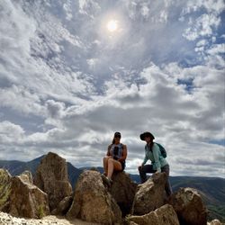
It was a fun hike I did with 2 of my BFs. The weather cooperated with us, perfect temperature. That said, I agree with other Yelpers, part (opened field, last mile near Eagle Rock formation) of the hike was windy. We parked our car across from the fire station, got the idea from reading the reviews. Note: -2mi shaded -1.5mi no shade -3.5mi from first gate, 7mi round trip -3 gates total -I only needed one bottle of water -Bring snacks Things We Came Across: -3 horses and riders -Cows -A rabbit -A snake (see pic) We did not encounter bugs. Our hiking experience was pleasant and enjoyable. Happy hiking!

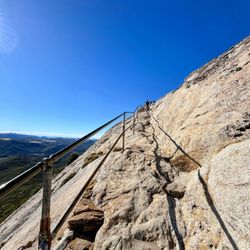
This was a really cool hike; about 1 hour 40 minutes drive. Parking is across the fire station: the street or the community resource center parking lot. Entrance of the trail is located to the right of the fire station. You will notice there is a chain with a clip to lock the gate. Just unlock and clip it back when you walk through the gate. The first 0.25 mile wasn't much to see and the dirt trail was easy to follow. Once you hit the woods, that's where things slowly start getting interesting. Plenty of shades in there and you kind of walk adjacent to a small stream. Once you exit the woods, it gets really chilly and windy out there even with the sun beating down on you especially at the Eagle Rock! Plenty of nice views of the distant hills and mountains! My Garmin Instinct clocked the trail at 6.6 miles at 2.5 hours. This includes waiting for people to take their poses and pictures at the rock. The earlier you go in the morning (before 8am), the more likely you won't have to wait too long for a picture with the Eagle.

Thank goodness for other Yelpers as the gate to the trail entrance is easy to miss. If you are facing the front of the Cal Fire Warner Springs fire station (routed to here on GPS), the entrance is on the right of it. We parked directly across the street on the side of the road. Look for the little green tree signage saying the severity of fires. Park on that side. Proceed across the street and make sure you lock/close the gates behind you to prevent livestock (cows) from escaping. The first half of the trail is fairly shaded- lots of greenery as you walk along the riverbed/stream. Slight incline but not difficult at all as most of the terrain is flat. There are lots of animals to see, keep an eye out for cow and horse turds, and bees (there is one tree labeled as such). It's pretty scenic, even when the shade disappears and you start walking through more dessert terrain. You eventually hit Eagle Rock in 3.14 miles (according to my watch). Enjoy the scenery, take some photos, and have a snack. Then head back out for a grand total of 6. 28 miles or so. It did get pretty windy by eagle rock, a light sweater or jacket is helpful. Also bring water, snacks, a hat, sunglasses, chapstick, and sunblock. Is the hike worth it?! YES!!!!!!!


This was a fantastic hike! Especially after reaching the Eagle Rock! Something spectacular to see! We happen to find parking in a dirt lot off the side of the road near cal fire station. People were parking along the road as well. There are public restrooms available across the street from the cal fire station. I happened to be with people that hiked this trail before so they were able to find the entrance to the trail. The entrance is on the same side of the fire department. This is a dirt trail and you will find parts were it may be narrow and areas where you find divots so be cautious and where proper footwear. I heard that hiking during the springtime you will find a lot of nature in bloom. My hike was in November so no flowers and greenery, but still a beautiful hike. There were plenty of birds swarming and singing among the oak trees. You will come to learn that this is part of the PCT (Pacific Crest Trail). You'll find PCT markers along the way. There are slight inclines that may slow you down, but this trail is totally doable for kids who like to hike. I really liked it because no switch backs involved and it was mostly flat for a change. I hope to take this hike again in the springtime to enjoy more beauty in while in bloom, and to see that magnificent eagle.

The Mighty Eagle! This Eagle Rock Trail is a mostly flat (3.2 there and 3.2 back) hike through the Warner Springs back country. You'll walk through shaded areas and rolling plains until you find the photogenic eagle. You're going to see many different Oak Trees and Chaparral on the trip there. Keep a keen eye open for Sugar Bush (Sumac). That's the red berry used as a seasoning in local San Diego Mediterranean restaurants like Luna Grill and The Kebab Shop. You'll know you're close to the eagle when you see an outcropping of tall rocks on a hill ( they stick out like Stonehenge). The Mighty Eagle is seen from the back side. Feel free to climb on top! Need to Know: - The Eagle Rock Trail is actually part of the PCT (Pacific Crest Trail), a 2600 mile trail from Mexico to the Canadian border. - The Entrance Gate to the trail is just SOUTH of the cal fire station. - Snakes! - Look for the "Bee Trees" on a few of the old Oak trees. The Bee hive is inside the tree trunk. - You need to walk behind the rocks to see the Mighty Eagle. - Lots of cactus along the trail so kids need to pay attention. - Lots of cow poop!


When we want to do a relaxing hike we always hike to Eagle Rock with our furbabies. We like to go a little before the sun rises so we can beat the heat. If you're going to walk when the sun rises be sure to have a hat, sun block and plenty of water. After the first 30 min. of walking you wont have any shade to walk under.

Super easy hike that is good for all level of hikers even kids. Little to no incline with this hike which is relaxing and chill. Half of the hike have shade and the other half doesn't. If you go on a sunny summer day it can be a bad ideas since it can get really hot here because it is out in open field.

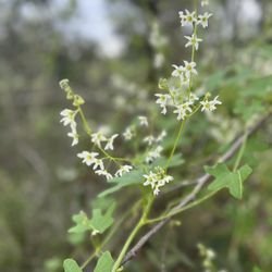
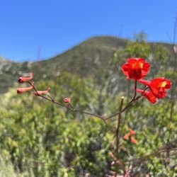
One of my favorite hikes in San Diego county- this one has it all!!! Perfect length, challenging but not TOO hard and the scenery OMG. I've included photos in my review from several trips to Eagle Rock over the years. You start out in a lovely shaded area by a stream, most of the incline is through a chaparral forest with manzanitas and blooming cactus, the last bit is a rolling prairie. The pinnacle of the hike is a huge rock formation that looks exactly like an eagle. I try to do this hike every year in the spring. Tons of flowers and gorgeous rolling grassy hills. This year we had a freakishly hot March and everything bloomed early and then got fried. It was still gorgeous though! We started early when it was still chilly and finished as the heat of the day was coming on. Be sure you keep an eye on the weather. It can get dangerously hot. I recommend a ton of water, hats and sunscreen. On the way home be sure to stop for Julian Pie in San Ysabel! read more


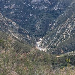
I had read about this random rock formation shaped like the profile of an eagle when I first started doing San Diego County hikes. We tackled this 6.4 mile out-and-back trail in Warner Springs on a recent weekend. It seemed like most of the hikers were completing the journey when we arrived after lunch as they were returning towards the trailhead off Highway 79. You can park along both sides of the road on the shoulder, but don't pull into the fire station lot adjacent to the trailhead. The Eagle Rock Hike is actually a segment of the larger Pacific Crest National Scenic Trail (PCT). The PCT spans over 2,500 miles and runs through California, Oregon, and Washington from the Mexican border to the Canadian border. The first half of the outbound portion was rather flat and ran next to a creek that was still flowing with a good amount of water from the March rainfall. There was plenty of shade from the trees in that area. Once you emerged from that section, the path veered into a valley with a few curves and gentle slopes. The landscape looked nothing like what you would expect in San Diego. It resembled the Great Plains with grasses and weeds along with hills and mountains off in the distance. This continued until you could see a set of rocks appearing what seemed to be the middle of nowhere. The approach was from the south side which was the rear of the formation. The view from the north definitely resembled an eagle about to spread its wings. Only one other group of hikers was present when we reached Eagle Rock. You can climb up the back side to the top where you end up next to the eagle's head. Think of photo opportunities like at Potato Chip Rock but without the wait. According to a hiking app, there was an elevation change of several hundred feet. It wasn't noticeable because of the gradual sloping. The round trip took just under three hours. The only real drawback was the lack of shade in the meadows. It was windy during our visit which dropped the temperature by at least 10 degrees in that portion. At the peak of summer, the heat and dry air can make this five-star inland trek less comfortable. PS: Not only is this trail not crowded, but it's very kid and pet friendly. read more


10 months ago
It was a fun hike I did with 2 of my BFs. The weather cooperated with us, perfect temperature. That said, I agree with other Yelpers, part (opened field, last mile near Eagle Rock formation) of the hike was windy. We parked our car across from the fire station, got the idea from reading the reviews. Note: -2mi shaded -1.5mi no shade -3.5mi from first gate, 7mi round trip -3 gates total -I only needed one bottle of water -Bring snacks Things We Came Across: -3 horses and riders -Cows -A rabbit -A snake (see pic) We did not encounter bugs. Our hiking experience was pleasant and enjoyable. Happy hiking! read more


This was a really cool hike; about 1 hour 40 minutes drive. Parking is across the fire station: the street or the community resource center parking lot. Entrance of the trail is located to the right of the fire station. You will notice there is a chain with a clip to lock the gate. Just unlock and clip it back when you walk through the gate. The first 0.25 mile wasn't much to see and the dirt trail was easy to follow. Once you hit the woods, that's where things slowly start getting interesting. Plenty of shades in there and you kind of walk adjacent to a small stream. Once you exit the woods, it gets really chilly and windy out there even with the sun beating down on you especially at the Eagle Rock! Plenty of nice views of the distant hills and mountains! My Garmin Instinct clocked the trail at 6.6 miles at 2.5 hours. This includes waiting for people to take their poses and pictures at the rock. The earlier you go in the morning (before 8am), the more likely you won't have to wait too long for a picture with the Eagle. read more


Thank goodness for other Yelpers as the gate to the trail entrance is easy to miss. If you are facing the front of the Cal Fire Warner Springs fire station (routed to here on GPS), the entrance is on the right of it. We parked directly across the street on the side of the road. Look for the little green tree signage saying the severity of fires. Park on that side. Proceed across the street and make sure you lock/close the gates behind you to prevent livestock (cows) from escaping. The first half of the trail is fairly shaded- lots of greenery as you walk along the riverbed/stream. Slight incline but not difficult at all as most of the terrain is flat. There are lots of animals to see, keep an eye out for cow and horse turds, and bees (there is one tree labeled as such). It's pretty scenic, even when the shade disappears and you start walking through more dessert terrain. You eventually hit Eagle Rock in 3.14 miles (according to my watch). Enjoy the scenery, take some photos, and have a snack. Then head back out for a grand total of 6. 28 miles or so. It did get pretty windy by eagle rock, a light sweater or jacket is helpful. Also bring water, snacks, a hat, sunglasses, chapstick, and sunblock. Is the hike worth it?! YES!!!!!!! read more


3 years ago
This hike was fun. Really recommend kid friendly. 3 miles in we seen cows a coyote. Not crowded. Lots of shade too read more

3 years ago
I adore this trail! It has two different terrains and so much wild life. The trail is fairly well laid out and easy to follow. Go in the morning and then hit Julian beer co in town :) read more

7 years ago
This was a fantastic hike! Especially after reaching the Eagle Rock! Something spectacular to see! We happen to find parking in a dirt lot off the side of the road near cal fire station. People were parking along the road as well. There are public restrooms available across the street from the cal fire station. I happened to be with people that hiked this trail before so they were able to find the entrance to the trail. The entrance is on the same side of the fire department. This is a dirt trail and you will find parts were it may be narrow and areas where you find divots so be cautious and where proper footwear. I heard that hiking during the springtime you will find a lot of nature in bloom. My hike was in November so no flowers and greenery, but still a beautiful hike. There were plenty of birds swarming and singing among the oak trees. You will come to learn that this is part of the PCT (Pacific Crest Trail). You'll find PCT markers along the way. There are slight inclines that may slow you down, but this trail is totally doable for kids who like to hike. I really liked it because no switch backs involved and it was mostly flat for a change. I hope to take this hike again in the springtime to enjoy more beauty in while in bloom, and to see that magnificent eagle. read more


2 years ago
The Mighty Eagle! This Eagle Rock Trail is a mostly flat (3.2 there and 3.2 back) hike through the Warner Springs back country. You'll walk through shaded areas and rolling plains until you find the photogenic eagle. You're going to see many different Oak Trees and Chaparral on the trip there. Keep a keen eye open for Sugar Bush (Sumac). That's the red berry used as a seasoning in local San Diego Mediterranean restaurants like Luna Grill and The Kebab Shop. You'll know you're close to the eagle when you see an outcropping of tall rocks on a hill ( they stick out like Stonehenge). The Mighty Eagle is seen from the back side. Feel free to climb on top! Need to Know: - The Eagle Rock Trail is actually part of the PCT (Pacific Crest Trail), a 2600 mile trail from Mexico to the Canadian border. - The Entrance Gate to the trail is just SOUTH of the cal fire station. - Snakes! - Look for the "Bee Trees" on a few of the old Oak trees. The Bee hive is inside the tree trunk. - You need to walk behind the rocks to see the Mighty Eagle. - Lots of cactus along the trail so kids need to pay attention. - Lots of cow poop! read more


5 years ago
3 years ago
4 years ago
We absolutely loved this hike. I recommend this hike is friendly to all ages. However, it is a very long hike to the eagle rock but very well worth it! Make sure to brings lots of water and a sacked lunch!! read more


7 years ago
AWESOME HIKE! Went with our doggie friends! Started early, it is a well maintained trail, dog friendly and has cows... the dog found some bones of a cow lol the eagle is awesome! read more


7 years ago
When we want to do a relaxing hike we always hike to Eagle Rock with our furbabies. We like to go a little before the sun rises so we can beat the heat. If you're going to walk when the sun rises be sure to have a hat, sun block and plenty of water. After the first 30 min. of walking you wont have any shade to walk under. read more


Super easy hike that is good for all level of hikers even kids. Little to no incline with this hike which is relaxing and chill. Half of the hike have shade and the other half doesn't. If you go on a sunny summer day it can be a bad ideas since it can get really hot here because it is out in open field. read more


The hike itself was not exciting or pleasant but the reward (Eagle rock!) you get at the end was worth it! I wouldn't call this really a hike since it was very flat and not much incline. The calorie burner would just be from the duration of the "walk" which was about 7-8 miles. Remember to check alltrails.com to get the right gps location to the start of the trail. I tried to change it but I don't think Yelp allowed it. It's actually to the right of the firestation on 79. The firemen there are nice and can point you to the gate where the trail starts. You will have to pass 3 gates before the trail starts. The first gate is chained but you can easily open it. What I hated about this hike was the amount of bugs we were fending off! OMG I was literally hitting my ears and body at least half of the hike. The first part of the hike is very shaded with a lot of trees but that comes with a lot of flies and mosquitoes! Make sure to use insect repellant!! Then the second part of the hike was dry, sunny and hot so the flies and mosquitos are gone but you encounter swamps of grasshoppers jumping all over your feet and legs! I've never seen so many grasshoppers in my life! Luckily I'm not scared of them but I did not enjoy feeling them jump all over my feet! And I was worry my dog may eat one! Haha Keep in mind we did go when it was hot - ~90-95F. However, there were actually more flies when it was cooler in the 80s but on our trip back, they all left since it was 95 degrees. The eagle rock was an amazing find! Not sure whether this is really nature or ?man made but it sure looked awesome! Glad we get to see it but the hike/walk was not the best. read more

2 years ago
Nice easy hike with a fun souvenir picture that you won't need to wait in line for like at potato chip... I wish I had paid more attention to the helpful yelp reviews documenting where to park etc. So #1, plug in "Eagle Rock trail head" and not "Eagle Rock". Rookie mistake. I parked on the side of the highway across from the fire station, but pretty sure that you can just park in the community service park (plus there's bathrooms, garbage and running water). We came on a beautiful day in Mid January. There were a bunch of other people on the trail, but not annoyingly crowded. The first half is shaded and has pretty trees and trails. The second half is more like traditional San Diego hikes, shrubs, no shade, out in the open dirt road. But then you wind your way up to this really cool Eagle Rock! My pup enjoyed the walk, although the 2nd half was pretty hot for her, so we stopped a bunch for water breaks. We all climbed up on the rock (including the pup) for a cool picture. And then headed back. read more


6 years ago
Really awesome hike! Just over 6 miles round trip, not too steep, varying scenery, and the actual rock is just breathtaking! Easy enough for kids, but plan on a couple breaks. We saw a coyote, wild turkey, and other small animals that made the hike even more enjoyable. read more


7 years ago
This is one of my favorite hikes, maybe *the* favorite in San Diego county. There are three distinct ecosystems in just three and a half miles. It's wooded with large bushes as you leave the highway, then desert, and finally grasslands that are grazed upon by cattle. I grew up on a dairy farm, so the Holsteins make my heart so happy. And then the eagle! This isn't a squint your eyes and cock your head to the left image. It's clearly an eagle. read more


8 years ago
Awesome hike! Entire hike (from entrance near the fire station) there and back took about two hours. If we bring the littles, it takes about 2 1/2 (to stop and hydrate ..and occasionally play in the stream!). My favorite part is when you're walking next to a creek..the sound is beautiful and relaxing. Nice amount of trees to provide shade, but we still wear hats as the sun is brutal after early morning. Cool foliage, adorable itty-bitty little flowers sprinkled along the desert portion of the hike. The actual rock is stunning! Try to go early morning, during the week, if you prefer it to be less crowded and enjoy the sounds of nature - without too many human interruptions Our 4 littles range in age from 5-10 and they were all able to make it with no issues at all. Look out for cow, dog, coyote and horse "presents" left on the trail!! read more
) love this hike!!! - Hiking Near Me - Warner Springs, California")
4 years ago
3 years ago
the rock! 6 miles round trip. took me a little less than 3 hours and i stopped at the eagle rock for a snack. went in december and the weather was perfect, nearly no one on the hike from 1-4pm read more

4 years ago
4 years ago
8 years ago
4 years ago
6 years ago
9 years ago
7 years ago
Great to trail to take dogs on. 1st mile is shady (big oaks) and has a small stream that parallels the path. Plenty of parking at the trailhead- near the fire station and JCT staging area. Met some great people along the way, just under 8 miles - looking forward to going back and doing it again read more


4 years ago
8 years ago
Awesome hike with great views. Not crowded at all like Potato Chip or Cowles or all those other hikes in San Diego. A little far but worth the drive. read more


Well let me start off make sure you park across the street from the Cal Fire Station in Warner Springs . Because there is not that many Spaces so arrive early so you get a space to park your car . Now let's get to the Trail !! First I arrive to Start This Eagle Rock Hike . Next I walk up to a Small gate where you begin the hike . So you open the gate and go through . Now the hike begins as I start to hike I notice there are lots of horse poop and dog poop all over the Trail and I begin to wonder does anyone ever clean this up because if you don't pay attention you might end up stepping in a big pile of Poop and get it stuck on your shoes and that is not good !!! Now as I continue on Trail I notice there a bunches of Trees Shrubs everywhere and it just feels like you are walking in a forest !! The Trail here is about 6 Miles to Eagle Rock and back !! So ware comfy Shoes and make sure to bring Sun block if you don't what to get sun burn . Let's continue on Trail as I Continue to Eagle Rock !! Make sure you pay attention to the Pillers that are posted on trail because it is easy to get lost . So if you Pay attention then you will be just fine . As I continue on trail you will notice near the End there are a bunch of Cows just chilling . So At the end It does pay off and The Eagle Rock is So Cool !!! Overall Good Hike and The Reward is nice !!! Perfect for taking pictures and hike is easy !! Not hard at all . read more


Page 1 of 2
More info about Eagle Rock Hike
Pacific Crest Trl
Warner Springs, CA 92086
Directions
Hours
Outdoor Amenities
Ask the Community - Eagle Rock Hike
Is there usually a long line to get your picture on the rocks?? Like at popular hikes like Potato Chip?
Depends on the month and temperatures. We went on a 96 degree day in August and no one was there at the top when we arrived and we saw only a few people along the trail the whole day.
Review Highlights - Eagle Rock Hike
You might also consider


Why does Yelp recommend reviews?
2 reviews that are not currently recommended
The reviews below are not factored into the business's overall star rating.
3 years ago
7 years ago
Eagle Rock Hike - hiking - Updated August 2026
Best of Warner Springs
People found Eagle Rock Hike by searching for…
Things to Do in Warner Springs, CA
Natural Hot Springs in Warner Springs, CA
Hiking Trails in Warner Springs, CA
Dog Friendly Hiking Trails in Warner Springs, CA
Off Road Trails in Warner Springs, CA
Fall Foliage in Warner Springs, CA
Waterfall Hike in Warner Springs, CA
Scenic Drive in Warner Springs, CA
Fall Colors in Warner Springs, CA
Hikes With Dogs in Warner Springs, CA
Paved Walking Trails in Warner Springs, CA
Picnic Areas in Warner Springs, CA
Fishing Spots in Warner Springs, CA
Hiking With Kids in Warner Springs, CA
Easy Hikes in Warner Springs, CA
Scenic View in Warner Springs, CA
Flower Fields in Warner Springs, CA
Lookout Points in Warner Springs, CA
View Points in Warner Springs, CA
Off Leash Dog Hikes in Warner Springs, CA
Stroller Friendly Hikes in Warner Springs, CA
Browse Nearby
Browse Brands
Browse Articles
People who viewed Eagle Rock Hike also viewed
Volcan Mountain Preserve
87 reviews
Palomar Mountain State Park
91 reviews
Hellhole Canyon
6 reviews
Borrego-Palm Canyon Campground & Trail
45 reviews
Barker Valley
2 reviews
Anza-Borrego Desert State Park
287 reviews
Oak Grove Trail to High Point
3 reviews
Dixon Lake
117 reviews
Hellhole Canyon Trail
11 reviews
Borrego Palm Canyon Trail
4 reviews