Hellhole Canyon Photos


You might also consider
More like Hellhole Canyon
Recommended Reviews - Hellhole Canyon
Start your review...

Reviews With Photos

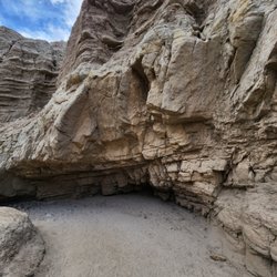
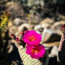
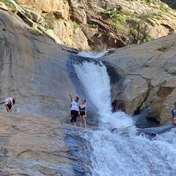
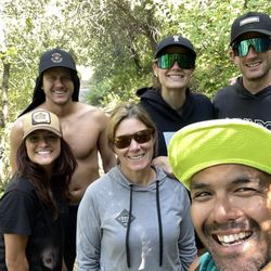
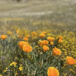
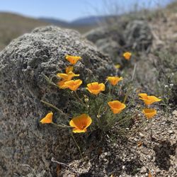
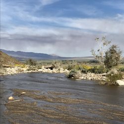
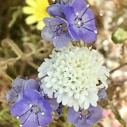
We did this hike yesterday during a day trip to Anza Borrego to see the superbloom. My husband and I started at around 8:15a in the morning and ended just about three hours later. This is about a 5.5 mile loop if you turn around at the waterfalls. The first 2 miles of the hike are fairly easy with lots of cacti and blooming wildflowers to see. There is really no shade at all here so get your sunscreen on plus a hat would be handy and bring lots of hydration. The last .75 miles of the hike, the trail has rocks, boulders, and tree stumps that you must climb on and around to get to your destination. You'll also encounter a creek that you need to cross a few times so be prepared to get your shoes wet or muddy. We wore our hiking boots so we were fine. There were parts on the hike here that the trail could go in two different directions so we kinda just made our best guess as to which way to go. You can't really get lost, but you may have to backtrack if you hit a dead end. We ran into other hikers who pointed us in the right direction so that helped a lot. The waterfall is not a huge one, but it's in a nicely shaded area where you can stop to relax, have a snack, and hydrate before making the trek back to your vehicle. Overall, this was a great workout with fantastic scenery and not hellish at all.

4 months ago
Surprisingly nice hike with a tougher end-game to reach the "waterfall". My biggest gripe with this trail isn't the $10 fee. It's the fact that this trail is poorly marked with wrong signage and no clear trail markers to get to the actual waterfall. There's also little to no internet serive here to double check. Tips - The trail to the waterfall starts behind the pay kiosk. No marking that this it the trail to the falls. The trail (little surprise trail) that's next to the bathroom isn't marked either. - About a mile or so into the hike you'll see a sign with an arrow pointing towards the hill.. IGNORE this sign and stay on the main trail. - The waterfall is basically at the third Oasis. Navigating through the Oases is like a labyrinth of different paths. Some are dangerous, some are easy, and some are dead ends. It's like a choose your own adventure book from the 80's and 90's. - Seeing a flowing waterfall is likely rare. Maybe early spring? - Best hiking is during the winter months or during a superbloom.. read more


12 years ago
I love to hike. This was one of my favorite hikes. 6 miles round trip. A waterfall oasis with ferns growing. Simply amazing. Wild lavender bushes. Ocotillo everywhere. Creosote. Yes they smell like your fireplace hence the name. Not easy but not really too hard a hike. A few places where your rock scrambling is required. However leave the 3 year olds home. Great fun. Enjoy! read more
We did this hike yesterday during a day trip to Anza Borrego to see the superbloom. My husband and I started at around 8:15a in the morning and ended just about three hours later. This is about a 5.5 mile loop if you turn around at the waterfalls. The first 2 miles of the hike are fairly easy with lots of cacti and blooming wildflowers to see. There is really no shade at all here so get your sunscreen on plus a hat would be handy and bring lots of hydration. The last .75 miles of the hike, the trail has rocks, boulders, and tree stumps that you must climb on and around to get to your destination. You'll also encounter a creek that you need to cross a few times so be prepared to get your shoes wet or muddy. We wore our hiking boots so we were fine. There were parts on the hike here that the trail could go in two different directions so we kinda just made our best guess as to which way to go. You can't really get lost, but you may have to backtrack if you hit a dead end. We ran into other hikers who pointed us in the right direction so that helped a lot. The waterfall is not a huge one, but it's in a nicely shaded area where you can stop to relax, have a snack, and hydrate before making the trek back to your vehicle. Overall, this was a great workout with fantastic scenery and not hellish at all. read more


15 years ago
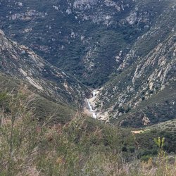
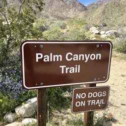
One of the more popular hikes is the palm canyon trail . . . Pfft! Who cares? What's more miraculous then a waterfall in the midst of a dry, seemingly dead desert? All though not all that impressive (24') it's a nice bit of heaven in comparison to the desert. There is quite the elevation gain through sandy and rocky terrain. A bit of boulder scrambling, and during the spring the flowers are interesting. A large spinney plant called ocotillo liters the trail too. Some of the path disappears, or seems to, you just have to navigate it. We almost missed the falls! (I would highly suggest going to the visitor center and getting a map) It's 6 miles, 3 there n' back. Bring water, especially if it spring-fall, 'tis muy calor! Anyhow definitely one off the better trails at Borrego. read more


6 years ago
More info about Hellhole Canyon
Co Hwy S22
Borrego Springs, CA 92004
Directions
Visit Website
http://www.parks.ca.gov
Hours
Outdoor Amenities
Ask the Community - Hellhole Canyon
You might also consider


Hellhole Canyon - hiking - Updated August 2026
Best of Borrego Springs
People found Hellhole Canyon by searching for…
Hiking Trails With Waterfalls in Borrego Springs, CA
Things to Do in Borrego Springs, CA
Swimming Holes in Borrego Springs, CA
Visitor Centers in Borrego Springs, CA
Sunset View in Borrego Springs, CA
Sand Dunes in Borrego Springs, CA
Redwood Trees in Borrego Springs, CA
Star Gazing in Borrego Springs, CA
Playgrounds in Borrego Springs, CA
Waterfalls in Borrego Springs, CA
Running Trails in Borrego Springs, CA
Swimming Lakes in Borrego Springs, CA
Off Road Trails in Borrego Springs, CA
Hiking With Kids in Borrego Springs, CA
Walking Trails in Borrego Springs, CA
Secret Spots in Borrego Springs, CA
Beautiful Views in Borrego Springs, CA
Tourist Attractions in Borrego Springs, CA
Lakes & Ponds in Borrego Springs, CA
Scenic View in Borrego Springs, CA
Parks for Kids in Borrego Springs, CA
Trending Searches in Borrego Springs, CA
Cliff Jumping near Hellhole Canyon
Dog Friendly Things To Do near Hellhole Canyon
Flower Fields near Hellhole Canyon
Free Picnic Areas near Hellhole Canyon
Lookout Points near Hellhole Canyon
Outdoor Activities near Hellhole Canyon
Peach Picking near Hellhole Canyon
River Swimming near Hellhole Canyon
River Tubing near Hellhole Canyon
Scenic Overlook near Hellhole Canyon
Swimming Holes near Hellhole Canyon
Things To Do On A Rainy Day near Hellhole Canyon
Browse Articles
Browse Nearby
BEST of Borrego Springs, California Restaurants near Hellhole Canyon
BEST of Borrego Springs, California Coffee near Hellhole Canyon
BEST of Borrego Springs, California Things to Do near Hellhole Canyon
BEST of Borrego Springs, California Scenic View near Hellhole Canyon
BEST of Borrego Springs, California Breakfast near Hellhole Canyon
BEST of Borrego Springs, California Shopping near Hellhole Canyon
BEST of Borrego Springs, California Campgrounds near Hellhole Canyon
BEST of Borrego Springs, California Motel near Hellhole Canyon
BEST of Borrego Springs, California Visitor Centers near Hellhole Canyon
Browse Brands
Related Searches in Borrego Springs, CA
Best Dog Hiking Trails Around Borrego Springs, California
Best Fishing Locations and Guides in Borrego Springs, California
Best Places for Horseback Riding in Borrego Springs, California
Best Sightseeing Experiences Available in Borrego Springs, California
Best Waterfalls and Swimming Holes in Borrego Springs, California
Check Out Off Road Trails in Borrego Springs, California
Discover Dog Friendly Trails to Explore in Borrego Springs, California
Discover Scenic Mountain Bike Trails Near Borrego Springs, California
Discover a Hiking Trail in Borrego Springs, California
Discover the Best Night Hike Trails in Borrego Springs, California
Dog-Friendly Hikes With Dogs in Borrego Springs, California
Enjoy Camping Adventures Around Borrego Springs, California
Enjoy Exciting Mountain Biking Adventures in Borrego Springs, California
Enjoy Off Leash Dog Hikes in Borrego Springs, California
Enjoy Tent Camping Spots Around Borrego Springs, California
Enjoy a Beautiful Waterfall Hike in Borrego Springs, California
Enjoy the Best Picnic Spots and Ideas in Borrego Springs, California
Enjoy the Best Walking Trails in Borrego Springs, California
Experience Stunning Sunset Views in Borrego Springs, California
Explore Beautiful Parks and Green Spaces in Borrego Springs, California
Explore Easy Hikes Perfect for All in Borrego Springs, California
Explore Fun Activities to Do in Borrego Springs, California
Explore Popular Campgrounds Near Borrego Springs, California
Explore Popular Scenic Overlook Points in Borrego Springs, California
Explore Top Dog Parks in Borrego Springs, California Near You
Explore the Best Swimming Holes Around Borrego Springs, California
Family Friendly Hiking With Kids in Borrego Springs, California
Find Cozy Camping Cabins in Borrego Springs, California
Find Popular Ziplining Spots Around Borrego Springs, California
Find Top Dog Friendly Parks to Visit in Borrego Springs, California
Hiking Trails With Waterfalls in Borrego Springs, California
Off Leash Dog Hiking Trails in Borrego Springs, California
Picnic Areas With BBQ Pits Available in Borrego Springs, California
Plan a Scenic Drive Route Near Borrego Springs, California
Popular Outdoor Activities to Try in Borrego Springs, California
Popular Picnic Spots to Visit in Borrego Springs, California
Popular Things to Do in Borrego Springs, California
Popular Things to See in Borrego Springs, California
Safe River Swimming Areas in Borrego Springs, California
Safe and Fun Parks for Kids in Borrego Springs, California
Top Dog Friendly Things to Do in Borrego Springs, California
Top Hiking Trails to Explore in Borrego Springs, California
Top Playgrounds for Kids to Enjoy in Borrego Springs, California
Top Running Trails to Explore in Borrego Springs, California
Top Swimming Lakes to Enjoy in Borrego Springs, California
Top Swimming Spots and Pools in Borrego Springs, California
Top Things to Do With Kids in Borrego Springs, California
Top-Rated Camping Sites in Borrego Springs, California
Walk Dog Friendly Hiking Trails in Borrego Springs, California