1. Alcoholic Pass

0

Borrego Springs, CA

Cancel

Open app

Search

Alcoholic Pass

3.7 (3 reviews)
Closed • Closed

Alcoholic Pass Photos

You might also consider

Recommended Reviews - Alcoholic Pass

Your trust is our priority, so businesses can't pay to alter or remove their reviews. Learn more about reviews.
Yelp app icon
Browse more easily on the app
Review Feed Illustration
Photo of Vicki C.
1303
840
1510

8 years ago

Helpful 24
Thanks 0
Love this 26
Oh no 0
Photo of Tiffany M.
55
186
98

16 years ago

Helpful 0
Thanks 0
Love this 1
Oh no 0

14 years ago
Helpful 0
Thanks 0
Love this 0
Oh no 0

You might also consider

Verify this business for free

Get access to customer & competitor insights.

Verify this business

Slot Canyon

Slot Canyon

4.7(83 reviews)
13.3 mi

It's definitely a must do hike when you're visiting Anza borrego, Borrego springs or even Julian. I…read morewent here early May so it was extremely hot, even though I reached the trailhead around 9am. The drive to the parking lot was a little weird because after you get off the freeway, there is a dirt road for about 1.5-2 miles on which there were a lot of signs that said "no vehicles allowed" and "foot traffic only" so I wasn't sure if I should be driving. Once k got there, there were other cars parked too so my assumption is that those signs are applicable only during some seasons. The parking lot looks flat but you can see to trail once you start walking towards the canyon. The hike was really nice, it was definitely more of a walk rather than any uphills. It can get pretty hot so starting early in the summer can be advantageous.
We decided to visit the Slot Canyon during our Borrego Spring trip. Although it doesn't compare to…read morethe slot canyon views in Arizona or Utah, it was picturesque. The slots were fairly easy to navigate except for a few areas where you had to climb down or squeeze through narrow openings. You can also take the trail above the canyon which gives you panoramic views of the desert. There are 2 bathrooms but no sinks in the parking lot. Most cars can get to the parking lot but it's quite dusty. Come prepared with some water, snack, sunscreen, hats, and sunglasses. It's $10 per day to visit the park. It's an honor system where you fill out the form, drop off the cash in box, and leave the parking pass on your dashboard. The one negative and reason for removing a star is the poor signage on the trail and how to get into the slots. When we went, there were only 2 other families but the signs were not clear which direction to go into the canyon or even back to the parking lot so we ended up taking a much longer and harder route than needed.

Photos
Slot Canyon
Slot Canyon
Slot Canyon - View point towards the end

See all

View point towards the end

Anza-Borrego Desert State Park - beavertail cactus

Anza-Borrego Desert State Park

4.7(288 reviews)
5.2 mi

As California's largest State Park, Anza-Borrego is another spot everyone should have on their…read morebucket list. They have some great trails, camping, star gazing, and a bunch of giant statues that are fun to check out. The visitor's center was fun with a friendly staff. Don't forget to ask about the Junior Ranger Program. We saw two coyotes outside the visitor's center. We did the Palm Canyon Trail. It was an easy and short trail that was perfect for kids. We walked past 4-5 bighorn sheep. That was very cool. Keep in mind there are certain areas that can only be reached if your vehicle has AWD. The town of Borrego Springs is nice with a couple restaurants, shops, and places to stay. Looking back, it would have been nice to spend the night to stargaze. Don't forget to hiking smart: sun protection and plenty of water. Stay on the trials. Leave no trace. And have fun.

Spectacular desert views just a short drive from San Diego or Los Angeles yet it feels like you're…read moreon another continent. Try a late March trip to see the desert floor ablaze in springtime flower colors, or the "secret" Dinosaur Trail, or searching for ancient Pictographs in the Blair Valley section of Coyote Canyon. Anza Borrego never disappoints for those seeking adventure right here in Southern California!

Photos
Anza-Borrego Desert State Park - White-lined Sphinx Moth (aka Hummingbird Moth) larvae - they love to eat all the wildflowers! (March 2024)

White-lined Sphinx Moth (aka Hummingbird Moth) larvae - they love to eat all the wildflowers! (March 2024)

Anza-Borrego Desert State Park - White-lined Sphinx Moth (aka Hummingbird Moth) larvae closeup!! They love to devour the wildflowers! (March 2024)

White-lined Sphinx Moth (aka Hummingbird Moth) larvae closeup!! They love to devour the wildflowers! (March 2024)

Anza-Borrego Desert State Park - White-lined Sphinx Moth (aka Hummingbird Moth) larvae - they love to devour the wildflowers! (March 2024)

See all

White-lined Sphinx Moth (aka Hummingbird Moth) larvae - they love to devour the wildflowers! (March 2024)

Borrego-Palm Canyon Campground & Trail - Stargazing

Borrego-Palm Canyon Campground & Trail

4.6(45 reviews)
4.5 mi

I went RV Glamping here last month! Great site. Electricity and water hookups. Campsite bathrooms…read morewere clean too! I saw there were showers, but I didn't use them. Our campsite was a nice layout, we had our picnic table right near where the RV got parked. I saw some had the table more off to the side in some bushes. Multiple hiking trails started at different points around the campsite. Stars were gorgeous at night!!

If you enjoy dark sky or full moon, Anza- Borrego Desert State Park is the place to go!…read moreLast June, we ventured to Borrego Palm Canyon Campground for camping, expecting a dark sky and starry night but instead encountered a full moon that turned the desert into a magical scene. The moonlight created an almost mystical atmosphere, making the desert feel like another planet. We set up our tent beside a stone ramada with a table and fireplace. The cleanest toilet we've ever seen was just steps away, which was a luxurious touch. Since it wasn't peak season, typically from March to April when wildflowers are in bloom and again from autumn onward, the park was quieter. We checked in with the DIY machine at the entrance of the campground, and friendly ranchers were around to offer help if needed. One rancher suggested that if we wanted to hike, we should start early and finish by 8:30am before the temperatures began to rise. ( Just a tip: download a campsite map beforehand because there's no internet service in the park) The desert, lit up by the moon, looked like something from another world. Rugged rock formations and the wide open space felt never ending, and with the moonlight highlighting the cool details of the landscape. The desert was so quiet and empty, It felt like the world had melted away, leaving just us and the serene, mystical surroundings.. Next morning, the heat cut our hike short with our cat, and it was a bit of an ordeal. Cats can be more sensitive to the heat, and she had a breathing issue and gasping for air right after we started hiking. We had to quickly rushed back to the car to help her cool down. So just be aware if you plan to bring your pets along. Despite this, that night remained a magical mix of peace and wonder, a cherished experience that I'll never forget.

Photos
Borrego-Palm Canyon Campground & Trail - Getting ready to cook dinner

Getting ready to cook dinner

Borrego-Palm Canyon Campground & Trail - Clean Bathroom

Clean Bathroom

Borrego-Palm Canyon Campground & Trail - The ramada

See all

The ramada

Volcan Mountain Preserve - Mountain Lion tracks

Volcan Mountain Preserve

4.6(87 reviews)
19.2 mi

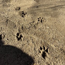
If you find yourself in the quaint mountain town of Julian, CA looking to stretch your legs, I…read morehighly recommend the scenic 5 mile out-and-back hike up Vulcan Mountain. Despite being a moderate trail with over 5353 feet of elevation gain, the well-marked route makes the hike accessible and enjoyable. We found ample parking right off the road at the trailhead. There were even clean porta-potties here for one last pitstop before starting on our way. The trail was extremely dog-friendly for our pup, though we did see signs warning of mountain lions in the area. While we thankfully didn't spot any big cats, we did catch a glimpse of some large paw prints in the dirt! As we switchbacked under a lush forest canopy, we were treated to spectacular views of the Volcan Mountain Wilderness through breaks in the trees. The vista from the top of Vulcan Mountain was an incredible payoff for our efforts. We took triumphant photos in front of the commemorative summit sign to celebrate our achievement. After admiring the sights, we retraced our steps back to the car. The descent went quickly with the help of the thought of lunch waiting for us. With beautiful wooded scenery, capped off by a panoramic summit viewpoint overlooking Julian and beyond, this was a quintessential SoCal day hike that I'd take visitors on to showcase the natural beauty surrounding this charming mountain escape. Whether you stop for a slice of apple pie before or after, no trip to Julian is complete without conquering Vulcan Mountain!

We tackled Volcan Mountain Trail with an eight-year-old, so we didn't make it the full way but it…read morewas such a nice experience. We also brought along our dog as it is a dog friendly trail as long as your dog is on a leash. The trail starts out pretty steep, but it's well-marked with clear paths throughout. One thing I really loved was all the signage explaining local plant life and animal tracks so it made the hike feel educational and engaging. My kiddo was really into looking at the different animal paw prints. This trail is great for hiking enthusiasts and beginners alike but just know your limits and pace yourself if you're newer to hiking. I would definitely say if it's sunny to make sure you bring plenty of water with you, but there are a lot of shady spots on this trail so that is a nice change from the hikes that are closer to coastal San Diego.

Photos
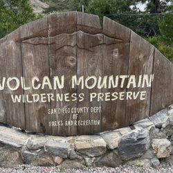
Volcan Mountain Preserve - Sign at the trailhead

Sign at the trailhead

Volcan Mountain Preserve

See all

Font's Point Vista - moonrise just after sunset - unknown couple

Font's Point Vista

5.0(3 reviews)
7.7 mi

Oh man Font's Point really awed me with an amazing landscape. I liked this place so much I came…read morehere two days in a row during my stay in Borrego Springs/Anza Borrego. Very picturesque views of the badlands, something I had not seen up close like this. It does require a short drive in sand that should be done with a car with some clearance. A fun adventure for sure!

**GPS coordinates to access the road to Font's Point shared in the Quick Tips.**…read more While visiting California's Anza Borrego State Park, the trek out to Font's Point is a must. However, one caveat is YOU MUST HAVE A 4WD VEHICLE! Don't risk it otherwise. Wayyyy too many people get stuck on the way in or out. Although it's only a mile each way, the road is extremely rough and unkept. Imagine driving on a sand dune.. that's what it's like. Sunrise and sunset here is the ideal time--though driving to/from the viewpoint in the dark may be tricky. Some folks decide to hike in and out but if you do so bring plenty of water. There is no shade whatsoever so doing it in the summer or during the year midday is not recommended. Do know that your feet sink as you walk in the sand so it's not easy feat for 2 miles round trip. With all this said, once you arrive at the viewpoint above the Borrego Badlands, the views are truly stunning. You can see the "mirage-like" Salton Sea and Mexican border in the distance. All of the fissures and change colors on the hills are astounding. Be sure to get a picture of yourself high up on the ridge to be able to capture the scale.

Photos
Font's Point Vista - Just after sunset

Just after sunset

Font's Point Vista - Fonts Point

Fonts Point

Font's Point Vista - Fonts Point Peak

See all

Fonts Point Peak

Eagle Rock Hike - Spring 2019

Eagle Rock Hike

4.7(56 reviews)
14.9 mi

One of my favorite hikes in San Diego county- this one has it all!!! Perfect length, challenging…read morebut not TOO hard and the scenery OMG. I've included photos in my review from several trips to Eagle Rock over the years. You start out in a lovely shaded area by a stream, most of the incline is through a chaparral forest with manzanitas and blooming cactus, the last bit is a rolling prairie. The pinnacle of the hike is a huge rock formation that looks exactly like an eagle. I try to do this hike every year in the spring. Tons of flowers and gorgeous rolling grassy hills. This year we had a freakishly hot March and everything bloomed early and then got fried. It was still gorgeous though! We started early when it was still chilly and finished as the heat of the day was coming on. Be sure you keep an eye on the weather. It can get dangerously hot. I recommend a ton of water, hats and sunscreen. On the way home be sure to stop for Julian Pie in San Ysabel!

I had read about this random rock formation shaped like the profile of an eagle when I first…read morestarted doing San Diego County hikes. We tackled this 6.4 mile out-and-back trail in Warner Springs on a recent weekend. It seemed like most of the hikers were completing the journey when we arrived after lunch as they were returning towards the trailhead off Highway 79. You can park along both sides of the road on the shoulder, but don't pull into the fire station lot adjacent to the trailhead. The Eagle Rock Hike is actually a segment of the larger Pacific Crest National Scenic Trail (PCT). The PCT spans over 2,500 miles and runs through California, Oregon, and Washington from the Mexican border to the Canadian border. The first half of the outbound portion was rather flat and ran next to a creek that was still flowing with a good amount of water from the March rainfall. There was plenty of shade from the trees in that area. Once you emerged from that section, the path veered into a valley with a few curves and gentle slopes. The landscape looked nothing like what you would expect in San Diego. It resembled the Great Plains with grasses and weeds along with hills and mountains off in the distance. This continued until you could see a set of rocks appearing what seemed to be the middle of nowhere. The approach was from the south side which was the rear of the formation. The view from the north definitely resembled an eagle about to spread its wings. Only one other group of hikers was present when we reached Eagle Rock. You can climb up the back side to the top where you end up next to the eagle's head. Think of photo opportunities like at Potato Chip Rock but without the wait. According to a hiking app, there was an elevation change of several hundred feet. It wasn't noticeable because of the gradual sloping. The round trip took just under three hours. The only real drawback was the lack of shade in the meadows. It was windy during our visit which dropped the temperature by at least 10 degrees in that portion. At the peak of summer, the heat and dry air can make this five-star inland trek less comfortable. PS: Not only is this trail not crowded, but it's very kid and pet friendly.

Photos
Eagle Rock Hike - Spring 2021 bloom

Spring 2021 bloom

Eagle Rock Hike - Spring 2019

Spring 2019

Eagle Rock Hike - Spring 2021 bloom

See all

Spring 2021 bloom

Hot Springs Mountain

Hot Springs Mountain

4.6(9 reviews)
12.3 mi

5 Stars for 5 reasons. 1. It's the highest Peak in San Diego…read moreCounty. 2. For being a beast the first two miles, which if done in heat would be brutal with no shade at all. The remaining 3 miles to the peak are a nice mix of rolling sections. (10 round-trip) 3. Beautiful scenically the entire way. 4. Easy to access with the exception that you drive way the hell out there, but it's a beautiful and easy drive coming from Poway. The $10 fee to get in is well within reason for use of the well maintained trail and parking. 5. The views are gorgeous at the top!!!! I'm an avid hiker and was disappointed in myself that I had not yet done this Awesome Hike until today. Highly recommend and I hope you enjoy it as much as we did. By the way, there's an adorable dog that we learned from the ranger/officer at the gate, lives at the campsite. Please bring a little something to leave out. PS. Dogs are allowed freely. My two fur babies did it with no problems, but bring water as there was snow at the top but no water sources that we saw anywhere.

My review is solely based on my hiking experience and not for the campground or other things here…read more I came here to summit Hot Springs Mountain as it's part of the San Diego Six Pack of Peaks challenge. Apparently it's the highest peak in San Diego as well. A fee of $10 is required. The trailhead is easy to find, just a little ways down after you pass the gate where the police vehicles are. The road is unpaved but is in fairly good condition, with no ruts or anything. Once you get to the restrooms the trailhead parking is to the left of it. There aren't really designated spots, you just need to park off of the road. The first 2 or so miles are in direct sunlight, and this is also where most of the elevation gain is. Once you get closer to the halfway point (around 2.4 miles) it's smooth sailing from there with just rolling hills and plateaus. You know you're almost there once you see the old lookout tower and reach the sign that points to the summit. Continue on this smaller trail and you'll reach the ladder and ropes to the summit. The summit can only fit a few people safely. I'm terrified of heights and sketchy things but still managed to do it. There are lots of bugs flying around on this trail. Other than that the trail is mainly a wide, well-maintained fire road. There's some forested areas you'll walk through, but nothing special. Good hike to get some elevation gain (2,200'+)! In total it took me 2 hours and 49 minutes (hiked up, ran down).

Photos
Hot Springs Mountain

See all

Borrego Palm Canyon Trail - Crossing the creek

Borrego Palm Canyon Trail

4.3(4 reviews)
5.2 mi

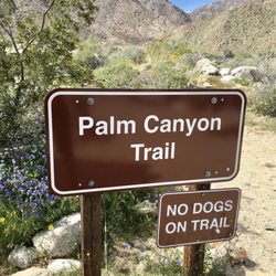
During the spring of 2019 I had the opportunity to hike this trail in the Anzo Borrega desert with…read morea good friend. If you are from out west, you will recall this was a phenomenal year of the super bloom and the desert was not left out. It was an absolutely stunning spring season filled with wildflowers. It is an easy 2.9 mile hike and relatively flat. Elevation gain was approximately 600 feet. The trail leads to the third largest palm oasis in California. The palms are tucked away in a water filled oasis. We enjoyed an awesome hike filled with gorgeous wildflowers and water. I could not believe how beautiful this desert was. We did have to park at the Visitors Center and walk an additional 1.25 miles to access the trailhead as the parking lot was already full. We did not have any issues with losing the trail as others have noted. Funny, there is an outdoor toilet for you to use, no door and no roof. I doubt many people use it but I guess if you really had to go you would. Ha! Ha! Be advised no dogs allowed on the trail and remember to Leave No Trace.

This is really a very easy hike. The hardest part is there are only a few spots to stop and get…read moresome shade. The whole hike is in the sun and it gets very hot. People were sitting in the water at the end to cool off so maybe bring a suit. The parking lot was full so I had to park at the visitors center and walk around 1.25 miles to the trail. That walk is very easy and flat

Photos
Borrego Palm Canyon Trail - Wish I knew what these gorgeous flowers are called.

Wish I knew what these gorgeous flowers are called.

Borrego Palm Canyon Trail - Indian Paintbrush

Indian Paintbrush

Borrego Palm Canyon Trail - Signage

See all

Signage

Alcoholic Pass - hiking - Updated October 2026

Loading...
Loading...
Loading...