Haystack Mountain State Park Photos


You might also consider
More like Haystack Mountain State Park
Recommended Reviews - Haystack Mountain State Park
Start your review...

Reviews With Photos


Came here 3 months ago I told my boyfriend here that I was falling in love with him. So for my birthday present he blindfolded me and brought me here and asked do I remember this place.. He said this is where you told me you were falling for me and I was already in love with you. I was shocked that he remembered that I told him and surprised that he he remembered it was here, the best Birthday gift ever, just becareful going back down the leaves make it slippery I almost fell 4x.


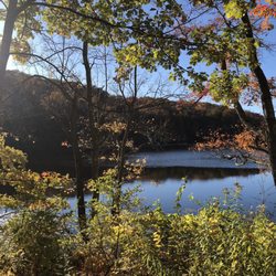
Come here for the view, stay for the sunset, leave with a new love for life and reason for being (that's what happens when you see the best view and sunset in New England) Skipping back a bit: So you drive here 2.5 hours from Boston thinking: "Is this going to be worth it?" The instant you drive thru the gated entrance you realize: "Heck Yeah!!... It is!" As you drive (or hike) up the scenic 2 mile road, that takes you 90% up the mountain, you are bathed in the wonderfully lush New England foliage: Green and vibrant in summer, afire with color in fall, and a picture post card in winter; when the snow sticks to the trees like a photograph by Ansell Adams! As you drive up, on your right, is this wondrous small pond and streaming brooks: ideal for the picnic lunch of the sandwiches you brought from Mike&Patty's and the cake from Finale, all washed down with a fresh sweet cider bought cheap from the farmer's stand you passed along Route 272. On your left is a classic New England Stone wall. Looking as old as time and as sturdy the mountain (see photo). You want to steal it to put in front of your house to be but your Honda Civic only holds so much. And you think: "hmmm...there MAY be a law against that" As your car creeps up the mountain, every sort of country creature scurries across the road. (You try not to hit them) Rabbits and Deer, and Moose, and Squirrels, and Fox, and Possum (the Possum you can hit) and field mice, and Porcupines (who you REALLY don't want to hit!) AND even an occasional Bear or Coyote or Wolf! But don't worry! None of these creatures will bother you...unless you are alone and very small. Then one wolf will say to other; "You know...I could go for a little Chinese tonight!....but this short girl/guy walking alone will do just fine!" You park your car at the top of the road and start the final trail to the top. Best thing about the country: everything is free! But you want to make sure you lock your doors and shut the windows or the Bears will go into your car looking for food and they get angry if they only find your Bon Jovi CDs. Since Bears, unlike white people, don't appreciate heavy metal. You hike the last part up to the summit. It is a rugged, but beautiful, half-mile trail to the top (see photo) Along the way you will be dazzled by the luxuriant mountain laurel, blossoming wild country flowers, and the humming birds who buzz right up to your ears until they determine you are not a lily . The trail is rather steep in parts, so allow 30 minutes if you are an inexperienced hiker, 20 minutes if you are a very experienced hiker and 5 minutes if your ex girl friend is chasing you (Note to self: stop dating cross country runners who are faster and hit harder then you) As you arrive at the top you are greeted by a magnificent medieval stone tower that looks right out of Ivanhoe (see photo) The 34 foot high stone tower sits at the summit of Haystack Mountain (1716 feet above sea level) As you climb the castle-like dark damp stone stairs you feel like Sir Thomas Moore being sent "to the tower!" just before the beheading for being "a loyal servant to my king...but first unto God!" Then you get to the top of the tower and are Simply Overwhelmed by a 360 degree view of why your ancestors risked everything to come to America! The beauty and the majesty of the Berkshire Mountains are second to none. To the North: You see the wild mountains of rural western Massachusetts and far in the distance, on a clear day, the very tips of the Green Mountains of Vermont. To the south: the rolling hills of the North West Corner of Connecticut and, on a very clear day, the edges of Long island sound. To the West you see the jagged purple Catskill Mountains of New York State (and you are going there next!) Needless to say: The sunsets from the tower are the stuff of the calendars you peruse at Boarders Book Store thinking to your self "Okay! That's gotta be as photoshopped as my Boss's pictures on eHarmony!" One sunset here and you realize that the photos are the one thing at Boarders that are real. The Only Thing more impressive then the view from the top of Haystack Mountain is a lightning show from the top of Haystack Mountain! Oooooooooooh! But Special Note to Yelpers!!! Walking down the dewy damp trail at night after a sunset can be very treacherous! So here is a tip: let the girl friend walk first so if there is anything slippery she will hit it and not you....kidding. You should both walk down carefully. And one thing is certain: you will come back here again and again...just like me!

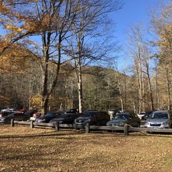
Haystack Mountain State Park is a great little park. It's a nice prominence above most of the rest of the area, so from the observation tower at the top, you get some beautiful views of the surrounding mountain ranges. There's a couple of ways you can approach the peak -- there's a road up most of the mountain, with a parking lot near the top, and several picnic areas along the way. This is OK but not exactly what we were interested in during our visit. There's another, longer hike from near the park entrance, and that's what we ended up doing on our visit. It's not a super challenging hike, but it does have a pretty decent elevation change on the way, so be prepared and bring water. During our visit, it was during spring wildflower season, and there were quite a few nice flowers to view during the hike. It was all around a really nice hike and park, and although it doesn't have a ton of facilities and is a bit rustic, I think this is one of CT's hidden gems, park wise. I highly recommend at least driving to the top if you're in the area.

I'm no fan of hiking. Especially when there's mud, a rocky trail steep enough to be called a "Mountain," and a tower at the top of the trail that requires even more climbing. But I admit that the view from the tower was worth the sweat, especially with fall colors sweeping over the hills. Lazy hiking newbies like me might find the trail a challenge, but others may find it easy. At the tower we found a big family picnic, with numerous senior citizens, small children, and even a basset hound with three-inch legs. We'd seen the dog earlier at the bottom of the hill. Yes, that basset hound beat me to the summit.

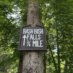
Hello Rapunzel! Built in 1929, this 34-foot tower is a must visit. It's about a 1 mile hike up with a slight incline. I was able to do it with my kids. Once you get to the tower and climb to the top, you can see the Litchfield hills, Berkshires, and even NY on a clear day. There is a parking area and the place was pretty quiet when we went. There was a couple of people but overall it was peaceful and not crowded at all. If you love history, hiking, and landmarks, this is worth a visit. read more


24 days ago
A picturesque State Park. The tower and the pond are worth a visit. The trail leading up to the tower has a few steep sections but it's manageable. There are interesting features to see, lots of Mountain Laurels (late May early June blooms) and old stone walls. There are a few picnic tables spread throughout the park. It's a calm park in a very beautiful part of Connecticut. Definitely worth a visit. The tower has excellent panoramic views. read more


Came here 3 months ago I told my boyfriend here that I was falling in love with him. So for my birthday present he blindfolded me and brought me here and asked do I remember this place.. He said this is where you told me you were falling for me and I was already in love with you. I was shocked that he remembered that I told him and surprised that he he remembered it was here, the best Birthday gift ever, just becareful going back down the leaves make it slippery I almost fell 4x. read more


3 years ago
7 years ago
We loved our hike here. It's a very short hike about one mile to the castle and one mile back. The incline is very steep heading to the castle. Make sure to go to the top floor of the castle, the view is breathtakingly beautiful! read more


Come here for the view, stay for the sunset, leave with a new love for life and reason for being (that's what happens when you see the best view and sunset in New England) Skipping back a bit: So you drive here 2.5 hours from Boston thinking: "Is this going to be worth it?" The instant you drive thru the gated entrance you realize: "Heck Yeah!!... It is!" As you drive (or hike) up the scenic 2 mile road, that takes you 90% up the mountain, you are bathed in the wonderfully lush New England foliage: Green and vibrant in summer, afire with color in fall, and a picture post card in winter; when the snow sticks to the trees like a photograph by Ansell Adams! As you drive up, on your right, is this wondrous small pond and streaming brooks: ideal for the picnic lunch of the sandwiches you brought from Mike&Patty's and the cake from Finale, all washed down with a fresh sweet cider bought cheap from the farmer's stand you passed along Route 272. On your left is a classic New England Stone wall. Looking as old as time and as sturdy the mountain (see photo). You want to steal it to put in front of your house to be but your Honda Civic only holds so much. And you think: "hmmm...there MAY be a law against that" As your car creeps up the mountain, every sort of country creature scurries across the road. (You try not to hit them) Rabbits and Deer, and Moose, and Squirrels, and Fox, and Possum (the Possum you can hit) and field mice, and Porcupines (who you REALLY don't want to hit!) AND even an occasional Bear or Coyote or Wolf! But don't worry! None of these creatures will bother you...unless you are alone and very small. Then one wolf will say to other; "You know...I could go for a little Chinese tonight!....but this short girl/guy walking alone will do just fine!" You park your car at the top of the road and start the final trail to the top. Best thing about the country: everything is free! But you want to make sure you lock your doors and shut the windows or the Bears will go into your car looking for food and they get angry if they only find your Bon Jovi CDs. Since Bears, unlike white people, don't appreciate heavy metal. You hike the last part up to the summit. It is a rugged, but beautiful, half-mile trail to the top (see photo) Along the way you will be dazzled by the luxuriant mountain laurel, blossoming wild country flowers, and the humming birds who buzz right up to your ears until they determine you are not a lily . The trail is rather steep in parts, so allow 30 minutes if you are an inexperienced hiker, 20 minutes if you are a very experienced hiker and 5 minutes if your ex girl friend is chasing you (Note to self: stop dating cross country runners who are faster and hit harder then you) As you arrive at the top you are greeted by a magnificent medieval stone tower that looks right out of Ivanhoe (see photo) The 34 foot high stone tower sits at the summit of Haystack Mountain (1716 feet above sea level) As you climb the castle-like dark damp stone stairs you feel like Sir Thomas Moore being sent "to the tower!" just before the beheading for being "a loyal servant to my king...but first unto God!" Then you get to the top of the tower and are Simply Overwhelmed by a 360 degree view of why your ancestors risked everything to come to America! The beauty and the majesty of the Berkshire Mountains are second to none. To the North: You see the wild mountains of rural western Massachusetts and far in the distance, on a clear day, the very tips of the Green Mountains of Vermont. To the south: the rolling hills of the North West Corner of Connecticut and, on a very clear day, the edges of Long island sound. To the West you see the jagged purple Catskill Mountains of New York State (and you are going there next!) Needless to say: The sunsets from the tower are the stuff of the calendars you peruse at Boarders Book Store thinking to your self "Okay! That's gotta be as photoshopped as my Boss's pictures on eHarmony!" One sunset here and you realize that the photos are the one thing at Boarders that are real. The Only Thing more impressive then the view from the top of Haystack Mountain is a lightning show from the top of Haystack Mountain! Oooooooooooh! But Special Note to Yelpers!!! Walking down the dewy damp trail at night after a sunset can be very treacherous! So here is a tip: let the girl friend walk first so if there is anything slippery she will hit it and not you....kidding. You should both walk down carefully. And one thing is certain: you will come back here again and again...just like me! read more


 - Hiking Near Me - Norfolk, Connecticut")
9 years ago
Haystack Mountain State Park is a great little park. It's a nice prominence above most of the rest of the area, so from the observation tower at the top, you get some beautiful views of the surrounding mountain ranges. There's a couple of ways you can approach the peak -- there's a road up most of the mountain, with a parking lot near the top, and several picnic areas along the way. This is OK but not exactly what we were interested in during our visit. There's another, longer hike from near the park entrance, and that's what we ended up doing on our visit. It's not a super challenging hike, but it does have a pretty decent elevation change on the way, so be prepared and bring water. During our visit, it was during spring wildflower season, and there were quite a few nice flowers to view during the hike. It was all around a really nice hike and park, and although it doesn't have a ton of facilities and is a bit rustic, I think this is one of CT's hidden gems, park wise. I highly recommend at least driving to the top if you're in the area. read more


I'm no fan of hiking. Especially when there's mud, a rocky trail steep enough to be called a "Mountain," and a tower at the top of the trail that requires even more climbing. But I admit that the view from the tower was worth the sweat, especially with fall colors sweeping over the hills. Lazy hiking newbies like me might find the trail a challenge, but others may find it easy. At the tower we found a big family picnic, with numerous senior citizens, small children, and even a basset hound with three-inch legs. We'd seen the dog earlier at the bottom of the hill. Yes, that basset hound beat me to the summit. read more


In the heart of our small town Norfolk (located in the Northwest part of CT) Haystack Mountain peeks above all the trees as one of the many hidden gems in the "icebox of CT." This is not just a hike, you can walk your dogs through the entrance, fish in the pond, ride your bikes up the spiral roads until you get to the base of where you start your hike! Without taking breaks this will take a short 20-30 minutes walking up a challenging mountain to the Haystack tower. Seen in the pictures, a staircase to the top will give you a 360 degree view of the surrounding towns, Cannan, CT Sheffield and Great Barrington MA, Millerton, NY, and the rest of beautiful Norfolk. I chose to bring a bottle of wine and plastic cups with a few friends who had never visited Norfolk BUT feel free to bring water, because you'll need it. Absolutely astonishing view, relaxing, rejuvenating, and I can assure you it will provide anyone with a new appreciation for our environment. With the help of Norfolk protecting a great portion of the forest with no-building zones and land trusts, this fresh, untouched landscape will want you to move here! Or at least retire... read more


4 years ago
16 years ago
More info about Haystack Mountain State Park
Ask the Community - Haystack Mountain State Park
Review Highlights - Haystack Mountain State Park


Why does Yelp recommend reviews?
2 reviews that are not currently recommended
The reviews below are not factored into the business's overall star rating.
11 years ago
11 years ago
Haystack Mountain State Park - hiking - Updated July 2026
Best of Norfolk
People found Haystack Mountain State Park by searching for…
Watch Sunset in Norfolk, Connecticut
Scenic Drive in Norfolk, Connecticut
Things to Do in Norfolk, Connecticut
Fishing Spots in Norfolk, Connecticut
Hiking Trails With Waterfalls in Norfolk, Connecticut
Fishing in Norfolk, Connecticut
Scenic Night View in Norfolk, Connecticut
Beautiful Views in Norfolk, Connecticut
Picnic Areas in Norfolk, Connecticut
Stairs Workout in Norfolk, Connecticut
Sunset View in Norfolk, Connecticut
Running Trails in Norfolk, Connecticut
Secret Spots in Norfolk, Connecticut
Scenic Overlook in Norfolk, Connecticut
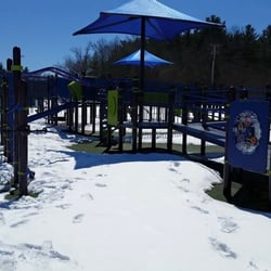
Playgrounds in Norfolk, Connecticut
Fall Foliage in Norfolk, Connecticut
Hiking With Kids in Norfolk, Connecticut
Dog Swimming in Norfolk, Connecticut
Night Hike in Norfolk, Connecticut
Walking Trails in Norfolk, Connecticut
What to Do in Norfolk, Connecticut
Places to Visit in Norfolk, Connecticut
Trending Searches in Norfolk, CT
Fireworks near Haystack Mountain State Park
Fishing Spots near Haystack Mountain State Park
Lakes near Haystack Mountain State Park
Parks near Haystack Mountain State Park
Playgrounds near Haystack Mountain State Park
River Swimming near Haystack Mountain State Park
Secluded Spots near Haystack Mountain State Park
Splash Pad near Haystack Mountain State Park
Strawberry Picking near Haystack Mountain State Park
Swimming Holes near Haystack Mountain State Park
Browse Articles
Browse Nearby
BEST of Norfolk, Connecticut Things to Do near Haystack Mountain State Park
BEST of Norfolk, Connecticut Coffee near Haystack Mountain State Park
BEST of Norfolk, Connecticut Parks near Haystack Mountain State Park
BEST of Norfolk, Connecticut Restaurants near Haystack Mountain State Park
BEST of Norfolk, Connecticut Swimming Holes near Haystack Mountain State Park
BEST of Norfolk, Connecticut Ski Resorts near Haystack Mountain State Park
BEST of Norfolk, Connecticut Campgrounds near Haystack Mountain State Park
BEST of Norfolk, Connecticut Taxis near Haystack Mountain State Park
BEST of Norfolk, Connecticut Breakfast near Haystack Mountain State Park
Browse Brands
Related Searches in Norfolk, CT
Best Fishing Locations and Guides in Norfolk, Connecticut
Best Nature Trails for Hiking in Norfolk, Connecticut
Best Off Leash Dog Parks in Norfolk, Connecticut
Best Parks for Parties and Events in Norfolk, Connecticut
Best Places for Horseback Riding in Norfolk, Connecticut
Best Spots for Star Gazing in Norfolk, Connecticut
Best Water Parks for Kids in Norfolk, Connecticut
Best Waterfalls and Swimming Holes in Norfolk, Connecticut
Check Out Great Playgrounds in Norfolk, Connecticut
Check Out Off Road Trails in Norfolk, Connecticut
Discover Baseball Fields Around Norfolk, Connecticut
Discover Dog Friendly Trails to Explore in Norfolk, Connecticut
Discover Fun Toddler Parks in Norfolk, Connecticut for Your Little One
Discover Popular Bike Trails in Norfolk, Connecticut
Discover Popular Photo Spots in Norfolk, Connecticut
Discover Scenic Mountain Bike Trails Near Norfolk, Connecticut
Discover Soccer Fields in Norfolk, Connecticut Near You
Discover Top Nature Parks to Visit in Norfolk, Connecticut
Discover a Hiking Trail in Norfolk, Connecticut
Discover the Best Beaches in Norfolk, Connecticut
Discover the Best Night Hike Trails in Norfolk, Connecticut
Discover the Best Running Track in Norfolk, Connecticut
Dog-Friendly Hikes With Dogs in Norfolk, Connecticut
Effective Stairs Workout Spots in Norfolk, Connecticut
Enjoy Camping Adventures Around Norfolk, Connecticut
Enjoy Scenic Night View Experiences in Norfolk, Connecticut
Enjoy the Best Picnic Spots and Ideas in Norfolk, Connecticut
Enjoy the Best Walking Trails in Norfolk, Connecticut
Exciting Cliff Jumping Spots in Norfolk, Connecticut
Explore Beautiful Botanical Gardens in Norfolk, Connecticut
Explore Bike Rentals Throughout Norfolk, Connecticut
Explore Easy Hikes Perfect for All in Norfolk, Connecticut
Explore Free Picnic Areas Around Norfolk, Connecticut
Explore Free Things to Do Around Norfolk, Connecticut
Explore Landmarks & Historical Buildings in Norfolk, Connecticut
Explore Parks With Pull Up Bars in Norfolk, Connecticut
Explore Popular Campgrounds Near Norfolk, Connecticut
Explore Popular Picnic Areas Around Norfolk, Connecticut
Explore Popular Scenic Overlook Points in Norfolk, Connecticut
Explore Popular Scenic Views Near Norfolk, Connecticut
Explore Popular View Points Around Norfolk, Connecticut
Explore Scenic Lakes to Visit in Norfolk, Connecticut
Explore Secret Spots Worth Visiting in Norfolk, Connecticut
Explore Summer Camps for All Ages in Norfolk, Connecticut
Explore Top Dog Parks in Norfolk, Connecticut Near You
Explore Top Gyms in Norfolk, Connecticut Now
Explore the Best Swimming Holes Around Norfolk, Connecticut
Family Friendly Hiking With Kids in Norfolk, Connecticut