Talcott Mountain State Park Photos


More like Talcott Mountain State Park
Recommended Reviews - Talcott Mountain State Park
Start your review...

Reviews With Photos

Great easy hike that's good for pets & small family members! Very accessable with great fall views and well maintained trails! This was our first time actually going up into Heublein Tower which was incredible! Especially during peak fall foliage. Take a drive down to Talcott Mountain Collective for a beer after your hike and enjoy more of CT's beauty! This is definitely my go-to hike to bring visitors.

This park is amazing, especially if you go during the fall to see all the foliage! It took me about 40 minutes to get from the bottom to heublein tower at a pretty moderate pace without stops. The initial 10-15 minutes of the hike are decently steep and will get your blood pumping but after that it levels off and becomes a much easier hike. All along the hike, you'll get views overlooking the surrounding area and definitely picture worthy. But when you get all the way to heublein tower, the 360 degree views at the top of the tower really is the best. The park/trail is well marked and easy to follow. Also, even though there are a ton of people on the trail, especially on the weekends, it never feels crowded because the trails are pretty wide. At the top there are a bunch of picnic tables so you can pack a lunch/snacks and eat them at the top with a great view. Would definitely recommend this place to bring family and anyone visiting! Well worth the effort for the views.

This is my favorite fall hike. It's a gravel trail that is easy to follow in the sense of not getting lost yet it's a moderately difficult hike due to it being quite a steep work out. However, the pay off on top is well worth all of the sweat and exertion. If the Heublein Tower is open you can tour it for free for even more spectacular 360 degree views of Ct. This hike should be every fall lovers fall tradition. Check their website for the Tower Toot which is their yearly fall festival with food and music. Free parking.

Great hike! Beautiful views of Simsbury too. If you go straight up and down you can reach the tower and get back to your car in a little less than an hour, but definitely buffer in some time for sight seeing. Try to get here early or go on a weekday/night because the lot fills up so quickly it has to be monitored or closed off by a local ranger. Be careful of the busy intersection while parking because of all of the cars.

I came here for a hike up to the Heublein Tower on a chilly Saturday morning. The trails are well developed and the views amazing. The trail is moderate difficulty with the hard part right at the beginning. The tower is currently closed due to Covid but when it is open it's a great, free, view!
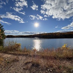
A fun hike loaded with history and views. There are many trails to explore and connect with while taking in nature. The walk up from the Simsbury side is moderately steep so plan accordingly with appropriate shoes and take your time if you are not used to exercising on inclines. However once on a he ridge the inclines are much more spaced and it is predominantly mild. Follow the trail past the tower (photo) to connect to Hoe Pond (photo) which offers a tranquil area off the beaten path.

One of my favorite places in CT to hike. It is a steep incline (but not like you're on your hands and knees) for the tower trail. It's a really wide path so it accommodates the large crowds that are sometimes there. We always see lots of families with little ones hiking. It is a relatively short considering the extremely satisfying view you get at the ridge. If you continue past the ridge, which I recommend you do, it's less of an incline and you'll come to Heublein Tower. Since you got some rest on a more flat path from the ridge to the tower, it is totally doable to climb the tower, if it is open. You'll be rewarded with great 360 views at the top. The stairs are one way so make sure to check out the rooms on the way up because there is no access on the way down. There are miles of other trails that are less busy and still beautiful as well.

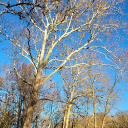
Home to the Heublein Tower, Talcott Mountain State Park is a classic hiking destination in central Connecticut. Location and scenic views are two of the main reasons why this mountain is not only so popular to hike but a favorite among locals in CT. To access the tower trail, follow the park entrance. The first entrance near the park sign is a heart-pumping 1.25 mile hike up to the tower and picnic area. A walk to the tower from here takes about 30-40 minutes. It's a gravel trail so wear comfortable sneakers or hiking boots. You can also take the more manageable entrance near the helipad, it's less intense and will connect you to the yellow-blazed trail which will also bring you to the tower. Both routes first climb to the top of the Talcott mountain ridge before traversing the ridge to the Heublein Tower. You can also access the summit of Talcott Mountain using the blue-blazed Metacomet Trail. It's much more of a rugged hiker trail but it doesn't feature quite as many scenic views at the Tower Trail. Always free but officially open to the public from Memorial Day weekend until Labor Day, Talcott Mountain State Park is a wonderful spot to enjoy fall foliage from above too where Heublein Tower packs impressive panoramic views of Hartford and the Connecticut hills.

What can I say that hasn't already been said? This place is amazing! In recent months, I've made Talcott Mountain State Park my weekend adventure day location. We always park down towards the end of the road and walk up past the entrance to the park, past the helicopter pad and into the "side" unmarked entrance. This particular trail is more steap and not as paved with rocks, but it's amazing. I clocked this route today at about a 2 mile hike up (2 mile down) using a fitness app on my phone. Obviously if you're going on a day like today after many days of rain, make sure to spray with bug spray! The mosquitos are deadly up the side paths as the trees hang lower than the more travelled routes. Another thing to consider is bringing your own water if you need it. Lately the water system has been out and there are no sources for water. Otherwise, it's a gorgeous park, clean and kept up and the views from the cliffs and tower are breathtaking! Definitely a must!!

Enjoyable hike with a nice goal at the end... Heublein Tower. There are kind of two stages to get to the tower. A moderately steep hike up the mountain up to the top of the ridge, and then you hike along the top to the tower. I recall it taking about 45 minutes to the tower, but I didn't rush and stopped along the way to check out the really nice views (which are little sidetrack paths off the main trail). The main trail itself is within a well-forested area and I found myself using my phone to see how close I was getting to the tower because I kept feeling like I was just about there (I wasn't). This was my second hike of the day so I was pretty pooped on the way down. I heard one mother tell her kids, "It's easier on the way down" and I wanted to shout, "Liar!!"

This is a great hike with really awesome views. I've only taken the trail to Heublein Tower, although I know there is at least one other trail in Talcott State Park. I also like that it is pretty short; it's a little over 2 miles round trip to the tower and back which is perfect if you don't have a ton of time to commit. The first part of the hike is pretty steep which makes for a good workout while the rest of the hike is pretty flat. I'd also recommend climbing the steps of Heublein Tower when you get to the top-- the views are amazing and the steps definitely add to the workout! If extra cardio isn't your thing, you can always pack a lunch and eat it at one of the picnic tables at the top of the mountain instead. If there was one complaint I had about this place, it would be that it gets very crowded on the weekend. There are tons of people including families, kids and groups; it kind of takes away from the hike for me. I'd recommend going during the week, if possible.

This is one of my favorite hiking trails in CT. Not too simple yet easy enough for kids or your dog to join as well. I come here a lot in the spring, fall and summer time! I love coming here to unwind from a stressful day and relax. The views are amazing and everyone is always so friendly. I bring my nephews with me and they love it. Plenty of places to sit and relax once you make it up there. Maybe even bring a small blanket and some snacks/take a nap. Whether you're looking for a little work out or just to relax this is the perfect place for it.

A park with a spectacular view! Talcott Mountain State Park is a 574-acre park located in Simsbury. Parking was spacious. The trail to the Heublein Tower is 1.25-miles long. The Tower can be seen from various parts of the state. It's a beautiful, white, 165-foot high tower with 360 degrees view. The trail was wide and on gravel. There was recent heavy rains so some of the trails had some washout. The hike was mostly up hill with some flat areas; I'd say it's moderate but it was a little bit more challenging for me because I was baby-wearing my child. My toddler did great on it. There were a couple of benches and logs to sit on along the way; pet waste receptacles were seen. My only qualm were the bugs, so don't forget bug spray like we did. Once we got to the top, there were a couple of porta potties and a kiosk. The view of the tower up close was exhilarating, so much history. There was an informational movie on in the garage with benches. There was a huge picnic pavilion and picnic tables throughout; a giant BBQ pit and another small one. The Heublein Tower was beautiful and built in 1914; it can withstand 100-mph winds. The staircases going up and down were meant to be one way; this was a great way to reduce pedestrian congestion and a fire hazard. There were historic relics and rooms decorated the way it was back in the day. Informational signage throughout the space. The tower used to be the summer home for Gilbert Heublein; a successful businessman whose company acquired Smirnoff Vodka and A1 Steak Sauce. The view from the ballroom was amazing and breathtaking. They had signs showing what we can see based on the direction. The hike back down the trail was easier, becareful though, some of the gravel were slippery and I saw a kid fall. Overall, a great hike and the view was worth it! read more


6 months ago
11 months ago
Great place for a hike up to the top. Highly recommended. You can see the beautiful vista all around. read more


9 months ago
Great easy hike that's good for pets & small family members! Very accessable with great fall views and well maintained trails! This was our first time actually going up into Heublein Tower which was incredible! Especially during peak fall foliage. Take a drive down to Talcott Mountain Collective for a beer after your hike and enjoy more of CT's beauty! This is definitely my go-to hike to bring visitors. read more


7 years ago
This park is amazing, especially if you go during the fall to see all the foliage! It took me about 40 minutes to get from the bottom to heublein tower at a pretty moderate pace without stops. The initial 10-15 minutes of the hike are decently steep and will get your blood pumping but after that it levels off and becomes a much easier hike. All along the hike, you'll get views overlooking the surrounding area and definitely picture worthy. But when you get all the way to heublein tower, the 360 degree views at the top of the tower really is the best. The park/trail is well marked and easy to follow. Also, even though there are a ton of people on the trail, especially on the weekends, it never feels crowded because the trails are pretty wide. At the top there are a bunch of picnic tables so you can pack a lunch/snacks and eat them at the top with a great view. Would definitely recommend this place to bring family and anyone visiting! Well worth the effort for the views. read more


4 years ago
This is my favorite fall hike. It's a gravel trail that is easy to follow in the sense of not getting lost yet it's a moderately difficult hike due to it being quite a steep work out. However, the pay off on top is well worth all of the sweat and exertion. If the Heublein Tower is open you can tour it for free for even more spectacular 360 degree views of Ct. This hike should be every fall lovers fall tradition. Check their website for the Tower Toot which is their yearly fall festival with food and music. Free parking. read more


Great hike! Beautiful views of Simsbury too. If you go straight up and down you can reach the tower and get back to your car in a little less than an hour, but definitely buffer in some time for sight seeing. Try to get here early or go on a weekday/night because the lot fills up so quickly it has to be monitored or closed off by a local ranger. Be careful of the busy intersection while parking because of all of the cars. read more

I came here for a hike up to the Heublein Tower on a chilly Saturday morning. The trails are well developed and the views amazing. The trail is moderate difficulty with the hard part right at the beginning. The tower is currently closed due to Covid but when it is open it's a great, free, view! read more

A fun hike loaded with history and views. There are many trails to explore and connect with while taking in nature. The walk up from the Simsbury side is moderately steep so plan accordingly with appropriate shoes and take your time if you are not used to exercising on inclines. However once on a he ridge the inclines are much more spaced and it is predominantly mild. Follow the trail past the tower (photo) to connect to Hoe Pond (photo) which offers a tranquil area off the beaten path. read more


17 years ago
One of my favorite places in CT to hike. It is a steep incline (but not like you're on your hands and knees) for the tower trail. It's a really wide path so it accommodates the large crowds that are sometimes there. We always see lots of families with little ones hiking. It is a relatively short considering the extremely satisfying view you get at the ridge. If you continue past the ridge, which I recommend you do, it's less of an incline and you'll come to Heublein Tower. Since you got some rest on a more flat path from the ridge to the tower, it is totally doable to climb the tower, if it is open. You'll be rewarded with great 360 views at the top. The stairs are one way so make sure to check out the rooms on the way up because there is no access on the way down. There are miles of other trails that are less busy and still beautiful as well. read more


Home to the Heublein Tower, Talcott Mountain State Park is a classic hiking destination in central Connecticut. Location and scenic views are two of the main reasons why this mountain is not only so popular to hike but a favorite among locals in CT. To access the tower trail, follow the park entrance. The first entrance near the park sign is a heart-pumping 1.25 mile hike up to the tower and picnic area. A walk to the tower from here takes about 30-40 minutes. It's a gravel trail so wear comfortable sneakers or hiking boots. You can also take the more manageable entrance near the helipad, it's less intense and will connect you to the yellow-blazed trail which will also bring you to the tower. Both routes first climb to the top of the Talcott mountain ridge before traversing the ridge to the Heublein Tower. You can also access the summit of Talcott Mountain using the blue-blazed Metacomet Trail. It's much more of a rugged hiker trail but it doesn't feature quite as many scenic views at the Tower Trail. Always free but officially open to the public from Memorial Day weekend until Labor Day, Talcott Mountain State Park is a wonderful spot to enjoy fall foliage from above too where Heublein Tower packs impressive panoramic views of Hartford and the Connecticut hills. read more


13 years ago
What can I say that hasn't already been said? This place is amazing! In recent months, I've made Talcott Mountain State Park my weekend adventure day location. We always park down towards the end of the road and walk up past the entrance to the park, past the helicopter pad and into the "side" unmarked entrance. This particular trail is more steap and not as paved with rocks, but it's amazing. I clocked this route today at about a 2 mile hike up (2 mile down) using a fitness app on my phone. Obviously if you're going on a day like today after many days of rain, make sure to spray with bug spray! The mosquitos are deadly up the side paths as the trees hang lower than the more travelled routes. Another thing to consider is bringing your own water if you need it. Lately the water system has been out and there are no sources for water. Otherwise, it's a gorgeous park, clean and kept up and the views from the cliffs and tower are breathtaking! Definitely a must!! read more


15 years ago
Enjoyable hike with a nice goal at the end... Heublein Tower. There are kind of two stages to get to the tower. A moderately steep hike up the mountain up to the top of the ridge, and then you hike along the top to the tower. I recall it taking about 45 minutes to the tower, but I didn't rush and stopped along the way to check out the really nice views (which are little sidetrack paths off the main trail). The main trail itself is within a well-forested area and I found myself using my phone to see how close I was getting to the tower because I kept feeling like I was just about there (I wasn't). This was my second hike of the day so I was pretty pooped on the way down. I heard one mother tell her kids, "It's easier on the way down" and I wanted to shout, "Liar!!" read more


 be aware. - Parks Near Me - Bloomfield, Connecticut")
This is a great hike with really awesome views. I've only taken the trail to Heublein Tower, although I know there is at least one other trail in Talcott State Park. I also like that it is pretty short; it's a little over 2 miles round trip to the tower and back which is perfect if you don't have a ton of time to commit. The first part of the hike is pretty steep which makes for a good workout while the rest of the hike is pretty flat. I'd also recommend climbing the steps of Heublein Tower when you get to the top-- the views are amazing and the steps definitely add to the workout! If extra cardio isn't your thing, you can always pack a lunch and eat it at one of the picnic tables at the top of the mountain instead. If there was one complaint I had about this place, it would be that it gets very crowded on the weekend. There are tons of people including families, kids and groups; it kind of takes away from the hike for me. I'd recommend going during the week, if possible. read more


This is one of my favorite hiking trails in CT. Not too simple yet easy enough for kids or your dog to join as well. I come here a lot in the spring, fall and summer time! I love coming here to unwind from a stressful day and relax. The views are amazing and everyone is always so friendly. I bring my nephews with me and they love it. Plenty of places to sit and relax once you make it up there. Maybe even bring a small blanket and some snacks/take a nap. Whether you're looking for a little work out or just to relax this is the perfect place for it. read more


7 years ago
14 years ago
A perfect casual afternoon's hike, with friends or family, because it has three key elements: varied terrain, great views, and a destination. Accessible for kids as young as 5 or 6. Gazing off the cliffs at the Farmington Valley and the Litchfield Hills will make you think of this quiet corner of Connecticut a little differently. Peer in the windows of Heublein Tower and you'll see a tableau evoking afternoon tea and evening cocktails in the roaring '20s. A well-spent 2 or 3-hour jaunt. read more

Great short hike if you are looking for an activity that won't take more than an hour. The view is beautiful and you get decent exercise with the varying slopes uphill. Plenty of photo ops along the way. Not ideal for toddlers though bc you can't bring a stroller and it's way to arduous to be carrying them. read more

8 years ago
This is my favorite place nearby Hartford downtown area. I usually come here when I don't like to go gym for exercising. Going to the Heublein tower and coming back is like good 45 mins to 1 hour exercise. Hike is easy enough. View from top is charming but don't expect anything exceptional. read more


What originally was supposed to be an easy hike to kick off the spring season ended up being a wet and muddy trek through the woods. The less than favorable weather however increased the challenge enough making the rather short hike more interesting. It was pouring rain and views off the cliffs were nonexistent because of this. However this left the mountain completely empty encouraging some of the shy wild life to creep from their hidings. The mountain denizens from orange colored lizard types, spotty amphibian types, stripey feathered types, and furry insect types all came out to play or feed on the beautiful new spring growth. The Tower Trail takes you to Heulein Tower through rocky, dirt roads and alongside the cliff's edge. You may or may not hear shotguns in the distance and with the mist completely obscuring the view of the valley below, you won't know where they are coming from - duck! The Heulin Tower is an eerie site to see on a miserable looking day. The lack of other people and mist creeping alongside us made for great moody photos. Don't forget to check out the old outdoor stove next to the picnic area and imagine what beasts were once cooked in there. Talcott Mountain is a short 10 minute drive from West Hartford - a big piece of nature right in the town's backyard. With various look out points along the cliff's edge and relatively easy trails, I can imagine this to be a popular outing with the locals and especially families on a nice, clear day. It's not the most challenging of hikes but allows for you to get a little lost (which we did) and explore small creeks and some rarely touched land. Although we veered off course for a good 30 minutes, the park is small enough to find your way back to the parking area... or rather end up in someone's backyard. - Limited parking alongside the entrance road - Picnic areas are available at the Tower - Total hike to Tower and back (including getting lost) = under 3 miles read more


First hike in the state of Connecticut! This will set the standard for all the hiking trails I trek in the spring. The difficulty of the hike is pretty low and we had the opportunity to go in the fall. Oh man what a beautiful view! We also took the trail to heublein tower, which was pretty cool. The tower is full of history and you get a pretty nice view from the top. I do wish there was a balcony at the top of the tower but oh well. The look out room is pretty neat and there are signs telling you what you're looking at which is awesome. Really nice way to spend some time with your friends. Parking can be tricky since this place is so popular! read more

Perfect 2 hr hike around a total of 2.5 miles to the top and back! The roads are a combo of rocks and dirt and the path are wide enough for 4 people to walk side by side. The hueblin tower at the top has a great lookout of mountains and has restrooms at the top . It is a nice breezy hike towards the top with this hot humid weather . Remember to bring water and bug spray ! read more

10 years ago
Talcott Park and the Heublein Tower are a fantastic place for a relaxing and mild hike for hikers of all experiences. I hiked the tower trail on a hot and humid day in August but thanks to the plentiful tree coverage I did not feel most of the heat. The trail is pretty simple once you are past the first half. The views are excellent, especially from the tower. I will definitely be hiking again in the Fall. read more


17 years ago
13 years ago
Ill admit.. Im not a huge hiker but I can be swayed when there is an end in site or a view, etc..So in my first 2 months back in CT I was "swayed" and it was pretty awesome and I would do it again. Great views and you can reward yourself with a nice picnic up top, plenty of picnic benches, etc.. The other cool thing is you can get up there through so many different trails. read more

16 years ago
8 years ago
This is a really beautiful hike, it's easy with some steeper, rockier areas depending on the trail you follow. We followed the blue trail which was a thinner and steeper path, but most of it ends up being wide, super easy trails. There are some really cool views here, with sharp drop offs so do be careful. We saw many kids and dogs on the trails. The best part is definitely the tower at the top. I loved walking through the museum (more like up the stairs) into the different little rooms. A lot of cool history there, including the history of Moscow mules! They really did a nice job with it and the view from the very top is awesome. Definitely recommend to hikers of all skill levels! read more


8 years ago
10 years ago
The views are breathtaking, the hike a bit pedestrian, pun intended, as the initial stage is a long wide slog uphill without much to captivate interest visually and an awful lot of people sharing the path if you go on a weekend. Plus, the parking is comically bad, as there's no lot and only areas of grass to pull onto. Problem is, you don't want to pull *all the way* onto these strips of turf, because they're all heavily inclined. So if someone parks a little ahead of you, you need to hope against hope that your wheels gain traction once you put it in reverse to gain some clearance space, or you'll roll into the vehicle ahead of you. So this is where the "comical" part comes in. Everyone parks one wheel on the grass, to stay safely off the road, and the other on the pavement, with a curb in between. Hard to fathom how such an attraction -- and a state park at that -- was devised with such Mickey Mouse parking available. The only plausible explanation is that the cultivation of the park predates the Model T. About the hike then . . . After the long, uninteresting climb, you reach a plateau, which stretches right out to the edge of the ridge overlooking vast swaths of central Connecticut. The trail at times presses right up against the very sheer drop. On very windswept days, you *will* consider whether *you'll* be swept up from the valley below. These spectacular views go on for about 15 minutes of hiking whereupon you come to the park's great manmade attraction: Heublein Tower., which, if you've ever played Tower Ridge Country Club, you'll recognize as that sole, haunting structure perched above you throughout the layout. It wasn't yet open to the public at this early time of year, so I can't report on the difficulty of ascending to its belfry, but you'd be batty not to investigate once it does open. In the final analysis, very recommended hike. The elevation changes will likely astonish strangers to the state of Connecticut, but in their own way, they are as dramatic as any you'll see elsewhere in the country, once you allow for scale, as the drop-offs are truly terrifying and the vistas quite magnificent, since you're way farther in the air than anything around you for dozens of miles. read more

Page 1 of 2
More info about Talcott Mountain State Park
Ask the Community - Talcott Mountain State Park
Can this mountain trail and peak be reached by hybrid bicycles? Can it connect to the Farmington Canal Trail?
Review Highlights - Talcott Mountain State Park


Why does Yelp recommend reviews?
Talcott Mountain State Park - parks - Updated July 2026
Best of Bloomfield
People found Talcott Mountain State Park by searching for…
Beaches in Bloomfield, Connecticut
Rock Climbing in Bloomfield, Connecticut
Things to Do in Bloomfield, Connecticut
Watch Sunset in Bloomfield, Connecticut
Scenic Drive in Bloomfield, Connecticut
Star Gazing in Bloomfield, Connecticut
Places to Take Pictures in Bloomfield, Connecticut
Swimming Lakes in Bloomfield, Connecticut
Scenic View in Bloomfield, Connecticut
Walking Trails in Bloomfield, Connecticut
Scenic Overlook in Bloomfield, Connecticut
Sunrise View in Bloomfield, Connecticut
Hiking Trails in Bloomfield, Connecticut
Playgrounds in Bloomfield, Connecticut
Water Parks in Bloomfield, Connecticut
Picnic Areas in Bloomfield, Connecticut
River Swimming in Bloomfield, Connecticut
Fishing Spots in Bloomfield, Connecticut
Lookout Points in Bloomfield, Connecticut
Photo Spots in Bloomfield, Connecticut
Beautiful Views in Bloomfield, Connecticut
Running Trails in Bloomfield, Connecticut
Browse Nearby
BEST of Bloomfield, Connecticut Restaurants near Talcott Mountain State Park
BEST of Bloomfield, Connecticut Coffee near Talcott Mountain State Park
BEST of Bloomfield, Connecticut Things to Do near Talcott Mountain State Park
BEST of Bloomfield, Connecticut Breakfast near Talcott Mountain State Park
BEST of Bloomfield, Connecticut Shopping near Talcott Mountain State Park
BEST of Bloomfield, Connecticut Wineries near Talcott Mountain State Park
Browse Brands
Browse Articles
People who viewed Talcott Mountain State Park also viewed
Case Mountain
33 reviews
Giuffrida Park
40 reviews
River Highlands State Park
8 reviews
Hop River State Park Trail
12 reviews
American Legion & People’s State Forests
4 reviews
Wadsworth Falls State Park
73 reviews
Quarry Park
6 reviews
Sessions Woods Wildlife Management Area
9 reviews
Farmington Canal Heritage Trail
7 reviews
Rattlesnake Mountain
5 reviews