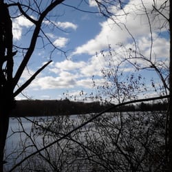
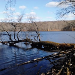
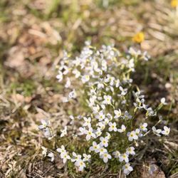
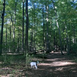
Rattlesnake Mountain Photos


 - Hiking Near Me - Farmington, Connecticut")

You might also consider
More like Rattlesnake Mountain
Recommended Reviews - Rattlesnake Mountain
Start your review...

2 years ago


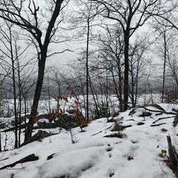
Trail has some lovely views, some steep up and down sections but no actual rock scrambling required, and if you plan ahead you can find the elaborate rock etchings done over 200 years ago by patients of an 18th century small pox inoculation center! Also, when I went most recently, somebody built a pretty sick rope swing in the woods. Not sure how safe it is, but if it doesn't crap out on you it's a nice little adrenaline rush if you start your swing at the tree branch. Now for some tips to get the most out of your hike: Pro tip #1: if you're doing this as an after work hike, park yourself at Alliance Occupational Health and catch the trailhead across the street. Can't speak as to whether this would be ok during their normal business hours tho. Pro tip#2: go to the local library where they can provide you with a map on how to find hospital rock, just off the trail, with stone carvings made 200 years ago. -side tip- bring flour with you to dust the rocks with so you can make out thyme carvings better for pictures Pro tip #3: Bugspray. read more
Really nice section of the Metacomet trail in central CT. Do not go to the address in the Yelp listing. There are two entrances I'm aware of: Rt6 in Farmington (close to 200 Colt Hwy, look on google maps for the parking area) and 372 in Plainville (across from 440 New Britain Ave). It's a 2.8 mile hike from 372 to Rattlesnake Cliff and the den while it's 1.3 miles from the Rt6 entrance and 4.2 miles from entrance to entrance. The hike between Pinnacle Rock and the Rattlesnake cliffs is pretty technical so if you're most interested in seeing the den/cave I would recommend starting from the Rt6 entrance. There is an old missile base about 1.5 miles from the 372 entrance but not much to see so don't be too excited. Bring your bug spray! read more


 - Hiking Near Me - Farmington, Connecticut")


9 years ago
More info about Rattlesnake Mountain
5 Trumbull Ln
Farmington, CT 06032
Directions
Hours
Outdoor Amenities


Rattlesnake Mountain - hiking - Updated May 2026
Best of Farmington
People found Rattlesnake Mountain by searching for…
Rock Climbing in Farmington, Connecticut
Parks in Farmington, Connecticut
Hiking Trails in Farmington, Connecticut
Playgrounds in Farmington, Connecticut
Fun Things to Do in Farmington, Connecticut
Things to Do With Kids in Farmington, Connecticut
Off Road Trails in Farmington, Connecticut
Walking Trails in Farmington, Connecticut
Beautiful Views in Farmington, Connecticut
Scenic View in Farmington, Connecticut
Caves in Farmington, Connecticut
Free Things to Do in Farmington, Connecticut
Running Trails in Farmington, Connecticut
Parks for Kids in Farmington, Connecticut
Scenic Overlook in Farmington, Connecticut
Views in Farmington, Connecticut
Pokestops in Farmington, Connecticut
Waterfall in Farmington, Connecticut
Pokemon Go in Farmington, Connecticut
Lookout Points in Farmington, Connecticut
Off Leash Dog Hikes in Farmington, Connecticut
Places to Walk in Farmington, Connecticut
Trending Searches in Farmington, CT
Botanical Gardens near Rattlesnake Mountain
Bounce House Rentals near Rattlesnake Mountain
Campgrounds near Rattlesnake Mountain
Cherry Picking near Rattlesnake Mountain
Cliff Jumping near Rattlesnake Mountain
Dog Friendly Things To Do near Rattlesnake Mountain
Flower Fields near Rattlesnake Mountain
Flower Shop near Rattlesnake Mountain
Garage Sales near Rattlesnake Mountain
Garden Center near Rattlesnake Mountain
Hair near Rattlesnake Mountain
Lakes & Ponds near Rattlesnake Mountain
Nurseries & Gardening near Rattlesnake Mountain
Outdoor Activities near Rattlesnake Mountain
Outdoor Furniture Stores near Rattlesnake Mountain
Parks near Rattlesnake Mountain
Party Equipment Rentals near Rattlesnake Mountain
Pedicure near Rattlesnake Mountain
Photo Spots near Rattlesnake Mountain
Pick Your Own Farms near Rattlesnake Mountain
Picnic Areas near Rattlesnake Mountain
Places To Take Pictures near Rattlesnake Mountain
Rock Quarry near Rattlesnake Mountain
Running Trails near Rattlesnake Mountain
Strawberry Picking near Rattlesnake Mountain
Sunrise View near Rattlesnake Mountain
Swimming Holes near Rattlesnake Mountain
Table And Chair Rentals near Rattlesnake Mountain
Browse Articles
Browse Nearby
BEST of Farmington, Connecticut Coffee near Rattlesnake Mountain
BEST of Farmington, Connecticut Restaurants near Rattlesnake Mountain
BEST of Farmington, Connecticut Things to Do near Rattlesnake Mountain
BEST of Farmington, Connecticut Breakfast near Rattlesnake Mountain
BEST of Farmington, Connecticut Walking Trails near Rattlesnake Mountain
BEST of Farmington, Connecticut Campgrounds near Rattlesnake Mountain
BEST of Farmington, Connecticut Parks near Rattlesnake Mountain
BEST of Farmington, Connecticut Hotels near Rattlesnake Mountain
BEST of Farmington, Connecticut Sledding near Rattlesnake Mountain
Browse Brands
Related Searches in Farmington, CT
Affordable Kayak Rental Services in Farmington, Connecticut
Best Fishing Locations and Guides in Farmington, Connecticut
Best Places for Horseback Riding in Farmington, Connecticut
Best Waterfalls and Swimming Holes in Farmington, Connecticut
Check Out Off Road Trails in Farmington, Connecticut
Discover Dog Friendly Trails to Explore in Farmington, Connecticut
Discover a Hiking Trail in Farmington, Connecticut
Discover the Best Night Hike Trails in Farmington, Connecticut
Dog-Friendly Hikes With Dogs in Farmington, Connecticut
Enjoy Camping Adventures Around Farmington, Connecticut
Enjoy Exciting Mountain Biking Adventures in Farmington, Connecticut
Enjoy Kayaking Adventures in Farmington, Connecticut
Enjoy Tent Camping Spots Around Farmington, Connecticut
Enjoy a Beautiful Waterfall Hike in Farmington, Connecticut
Enjoy the Best Picnic Spots and Ideas in Farmington, Connecticut
Enjoy the Best Walking Trails in Farmington, Connecticut
Exciting Cliff Jumping Spots in Farmington, Connecticut
Experience Thrilling White Water Rafting in Farmington, Connecticut
Explore Beautiful Parks and Green Spaces in Farmington, Connecticut
Explore Easy Hikes Perfect for All in Farmington, Connecticut
Explore Fun Activities to Do in Farmington, Connecticut
Explore Popular Campgrounds Near Farmington, Connecticut
Explore Popular Scenic Overlook Points in Farmington, Connecticut
Explore Scenic Lakes to Visit in Farmington, Connecticut
Explore the Best Beach Spots in Farmington, Connecticut
Explore the Best Boating Spots in Farmington, Connecticut
Explore the Best Swimming Holes Around Farmington, Connecticut
Family Friendly Hiking With Kids in Farmington, Connecticut
Find Beautiful Views in Farmington, Connecticut
Find Popular Ziplining Spots Around Farmington, Connecticut
Find the Best Parks for Picnics in Farmington, Connecticut
Find the Best Playgrounds to Visit in Farmington, Connecticut
Find the Best Scenic View Locations in Farmington, Connecticut
Hiking Trails With Waterfalls in Farmington, Connecticut
Off Leash Dog Hiking Trails in Farmington, Connecticut
Plan a Scenic Drive Route Near Farmington, Connecticut
Popular Fishing Spots to Explore in Farmington, Connecticut
Popular Outdoor Activities to Try in Farmington, Connecticut
Popular Picnic Spots to Visit in Farmington, Connecticut
Safe River Swimming Areas in Farmington, Connecticut
Safe and Fun Parks for Kids in Farmington, Connecticut
Top Climbing Spots and Gyms in Farmington, Connecticut
Top Paddleboarding Activities in Farmington, Connecticut
Top Places for Snorkeling in Farmington, Connecticut
Top Playgrounds for Kids to Enjoy in Farmington, Connecticut
Top Running Trails to Explore in Farmington, Connecticut
Top Swimming Lakes to Enjoy in Farmington, Connecticut
Top Swimming Spots and Pools in Farmington, Connecticut