1. Genoa Vista Trail

0

Gardnerville, NV

Cancel

Open app

Search

Genoa Vista Trail

5.0 (1 review)

Genoa Vista Trail Photos
You might also consider

Recommended Reviews - Genoa Vista Trail

Your trust is our priority, so businesses can't pay to alter or remove their reviews. Learn more about reviews.
Yelp app icon
Browse more easily on the app
Review Feed Illustration

1 year ago

Helpful 4
Thanks 3
Love this 4
Oh no 0

You might also consider

Verify this business for free

People searched for Hiking 670 times last month within 15 miles of this business.

Verify this business

Genoa Loop Trail

Genoa Loop Trail

5.0(4 reviews)
1.7 mi

It's been years since I last hiked this loop on a hot Summer day in July…read more This is a steep trail and there are parts that narrowed out, but hubby and I walked single file through those parts. We spent a day hanging out here, but we stopped halfway for a break and lunch in some shade. There are plenty of little rivers that flow below the waterfall. Hearing the waterfall kept us chugging along because we were ready to cool off. This wasn't the biggest waterfall, but we enjoyed our time in it. It was very private once we actually got down there and so happy we were in our own little oasis; we had the whole place to ourselves. With all the precipitation we received this year I can only imagine how beautiful and full everything is. I'm planning on revisiting this Summer to see how everything has grown.

Beautiful hike, spectacular views with a waterfall, this hike offers up rewarding treasures that…read moreonly Genoa can deliver. We set off on this trail that starts in the historic town of Genoa at the end of Carson Street which is north of Main Street (same side as the Genoa Bar - look for the Orchard House). You will see a gravel parking lot and the Genoa Loop Trail sign at the start of the trail. We opted for the 6 mile round trip to the waterfall adventure on this particular day as we headed out. With an elevation gain of 1410ft and many switchbacks be sure to carry plenty of H20, wear appropriate footwear, maybe bring something like a granola bar or fruit and as always pack out, what you pack in. The trail is well maintained, but can be narrow & steep at times with bicyclists and furry companions allowed on the trail too. Please be sure to bring leashes along with doggy mutt mitts aka poop bags, there is a trash can and mutt mitts at the beginning of the trail but better to be prepared and there are no poop fairies. Remember everyone is out there to enjoy the beauty of the Great Outdoors so ENJOY IT! We thoroughly enjoyed this hike, stopping along the way to take in the spring flowers, beautiful views, grab our binoculars to look upon Genoa, the Carson River & Jacks Valley. We crossed the creek throughout the trail with foot bridges, butterflies, and the reward of our hiking adventure was the Genoa Waterfall as it cascade over as we listened to it surrounded by the pine trees. So get out there, this is a GREAT waterfall hike with stunning views added bonus you are already in the quaint historic town of Genoa so why not check out the cute town and grab a bite to eat or libation. Enjoy and #moveyourbody!!

Photos
Genoa Loop Trail - Views while walking up :) Didn't make it up to the waterfall but still worth the view.

Views while walking up :) Didn't make it up to the waterfall but still worth the view.

Genoa Loop Trail
Genoa Loop Trail - Waterfall in the Genoa loop

See all

Waterfall in the Genoa loop

Carson Valley Trails - Trailhead

Carson Valley Trails

4.7(3 reviews)
4.0 mi

The Carson Valley Trails are a diverse cluster of expertly built and maintained trails in the…read moreCarson Valley. I spent the most time on the Pinyon Trail, the only Carson Valley Trail east of Gardnerville. It was carved into the side of the desert mountain with stunning views of the Sierra Nevada range. The trail wound around the side of the mountain with lots of turns, elevation gain, and elevation loss. It is the best Carson Valley trail for mountain biking if you want something manageable and not too dangerous. It has the most "flow" of any of the trails for biking. The best overall trail for mountain biking was the Clear Creek Trail. It started in a fire scorched desert section near a school and slowly wound its way up into the dense pine mountains. I could tell how much effort it took to build the trail because some sections hung on to the side of the mountain. Maybe I was overly cautious, but I slowly crept up each bend in the trail, cognizant of a potently biker whizzing down from above. The trail wasn't big enough for two bikers unless one biker was hugging the mountainside. I made it up to Knob Point before I was thoroughly exhausted and turned around. This was only about half of the trail. It's hard to explore all of the trails and still have a full time job. Fortunately, when I turned around I didn't have to exert much energy besides slamming on the brakes and guiding the bike down the mountain. It's a trail that one could push to their limit, then turn around and the let gravity bring them back.

It was a perfect day to hike this past weekend. It wasn't too hot nor cold. With our local weather…read morecooling it was probably the warmest weekend we'll have in awhile. I'm glad I was outdoors and got some much needed vitamin D and my blood pumping. It's not the easiest trail so I'd rethink this if you're bringing smaller children. We ran into other couples on the trail, but we were able to stop and enjoy our lunch midday away from anyone and start heading out before it started cooling down. We thoroughly enjoyed hiking this trail and look forward to returning next year.

Photos
Carson Valley Trails
Carson Valley Trails - Last view of the Eastern Sierras from the Carson Valley

See all

Last view of the Eastern Sierras from the Carson Valley

Lake Margaret

Lake Margaret

4.6(13 reviews)
19.1 mi

Absolutely loved this little lake! I took some Boy Scouts up to this lake this past weekend. We…read moregot to the trailhead a little later than expected 6:45pm but most of us had headlamps so we weren't that concerned and have done trips in the evening before. Some of the older scouts who leading in the front missed some of the trail markers and got us off track for a while, so watch out for those game trails that can lead you in circles. After we found the trail again it was pretty clear what to look for to stay on the trail. Like others have said look for the 3 cairn stones located all over the place, but also there are plenty of trees marked with an "i" in the bark. The "i" is for those who do the trail during snow season, with cross country skis or snowshoeing. We got to the lake around 9pm and were lucky to have an almost full moon which lit up the who place. Another group was setting up camp as well but there was plenty of room amongst the granite boulders. Deep on the east north east side of the lake there was a bigger place to set up tents but we wanted to be closer to the water. I woke up early, as I was the one one to bring a fishing rod and was not disappointed. Between the myself, another leader, and the scouts all taking turns we caught 8 trout in the morning. We saw a few fly fishers but it didn't look like they had much luck. Periodically we would see some day hikers arrive, some with their 4-legged companions, many of them water dogs. If you're there for the fishing just wait 10 min or so after a dog gets out and the fish will be biting again. There is a geocache at this lake, and some of the scouts found it, I remembered what the tip was and saw the marker from the picture and gave the scouts the info. They signed the logbook and re-hid the cache. Some of the boys went swimming, and I joined them but the water was very cold, as it is late September so it was to be expected. We had lunch and broke down camp and set back out to the cars. There were plenty of day hikers we passed along the trail, and enjoyed the views we missed the evening before. I absolutely loved the meandering brook that is about 0.5-0.75 miles from the trailhead. We stopped there and tried a few times with the fishing pole but as we were late to the cars we packed it back up after 5 min. Everyone loved the hike and had a blast at the lake. Definitely a place to visit again, but we'll bring more fishing poles next time.

Beautiful moderate difficulty hike with stacked stones to indicate the way. It was a great day hike…read morefor two young inexperienced hikers. We saw couples and families of all ages enjoying the scenery along the way. The lake itself is beautiful, but we didn't explore too much around it's banks. We found a nice little area to have lunch before heading back.

Photos
Lake Margaret
Lake Margaret - Our Group - Late Winter/Early Spring Hike

Our Group - Late Winter/Early Spring Hike

Lake Margaret

See all

Marlette lake trail

Marlette lake trail

5.0(6 reviews)
13.2 mi

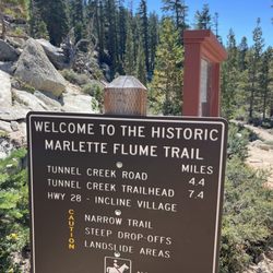
There are a few ways to reach Marlette Lake, all of them totally worth it, especially this time of…read moreyear. This trail takes you around Spooner Lake and up to Marlette. It's a 9 mile out and back with fairly gradual elevation gain, up through the trees, until you reach the lake. A great little workout. Marlette sits along the Flume Trail, so you're likely to see a lot of mountain bikers. Fun fact: The Flume Trail got its name because Marlette and the tributaries that feed it were part of a log flume system to carry logs used to build our region all the way down from as far as Virginia City! Marlette has a short fishing season, but people say it's grand if you make the trip. Of course you need to hike in to have that experience. This is definitely a trail worth checking out in our area!

We hiked the Marlette Lake Trail from Spooner Lake to Marlette Lake as a backpacking trip for my…read morefriend's bachelorette party! We added some extra distance at the end by hiking to the Marlette Peak Campground to stay for the night. From the parking lot to the campground was about 7 miles each way. The trail itself was well-maintained, moderate difficulty, and had everything you'd want in a good hike! Solid trail conditions. Beautiful mountain and lake views. Some sections of wildflowers. A good amount of sun but also some shaded parts. Gradual incline that never felt super steep, so the elevation gain felt manageable. We saw people hiking as well as mountain biking on this trail. There are several sections of aspen trees along this hike, so it's a great one to come back and do in the fall once the leaves turn yellow. The trailhead area has great facilities, the bathrooms were clean and there is ample parking. The park rangers I spoke to were friendly and helpful. There is a $10/car entry into this area but it's totally worth it, especially when you see how well they take care of it. I loved this hike and will continue to come back to Spooner for hikes in the future!

Photos
Marlette lake trail
Marlette lake trail
Marlette lake trail

See all

Genoa Vista Trail - hiking - Updated November 2026

Loading...
Loading...
Loading...