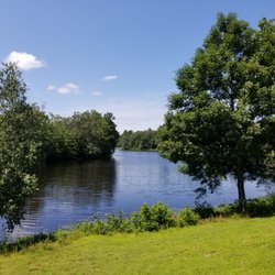
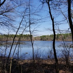
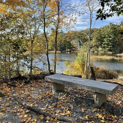
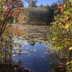
Franklin State Forest Photos


You might also consider
More like Franklin State Forest
Recommended Reviews - Franklin State Forest
Start your review...

6 years ago
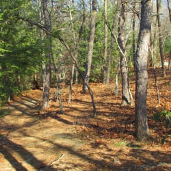
Wear hiking boots as it can be muddy AF in certain areas. Beautiful forest. I was the only hiker. I encountered a mountain biker and a few off-roader motorcyclists...all were very respectful though and weren't trying to run me off the trails...they always gestured for me to go first and waved friendly hellos. The trail seemed to be pretty well marked...just follow the yellow markers on the trees. It's about a 2 mile hike or slightly less. The terrain can be slippery if there's a lot of mud and if you are a bit klutzy like me, you need to watch out for tree roots/rocks, but w/ a good pair of hiking boots you should be good. read more


6 years ago
While the hike was enjoyable, most of it was dug up by dirt bikers and there was some on the trail while I was walking it. Other than that, it was good. Saw a deer and some other interesting birds. Wouldn't come back though, but worth the trip if you're within 20-30 minutes just to experience it and check it off the bucket list. read more
4 years ago
5 years ago
13 years ago
12 years ago
More info about Franklin State Forest
Grove St
Franklin, MA 02038
Directions
Hours
Outdoor Amenities
Ask the Community - Franklin State Forest


Franklin State Forest - hiking - Updated July 2026
Best of Franklin
People found Franklin State Forest by searching for…
Things to Do in Franklin, Massachusetts
Parks in Franklin, Massachusetts
Dirt Bike Riding in Franklin, Massachusetts
Walking Trails in Franklin, Massachusetts
Mountain Biking in Franklin, Massachusetts
Hiking Trails in Franklin, Massachusetts
Running Trails in Franklin, Massachusetts
Dog Friendly Hiking Trails in Franklin, Massachusetts
Hikes With Dogs in Franklin, Massachusetts
Bike Paths in Franklin, Massachusetts
Parks for Kids in Franklin, Massachusetts
Fun Things to Do at Night in Franklin, Massachusetts
Off Leash Dog Hiking Trails in Franklin, Massachusetts
Parks and Recreation in Franklin, Massachusetts
Off Road Trails in Franklin, Massachusetts
Waterfalls in Franklin, Massachusetts
Scenic Views in Franklin, Massachusetts
Secluded Spots in Franklin, Massachusetts
Places to Walk Around in Franklin, Massachusetts
Stroller Friendly Hikes in Franklin, Massachusetts
Easy Hikes in Franklin, Massachusetts
Sunday Fun Things to Do in Franklin, Massachusetts
Trending Searches in Franklin, MA
4th Of July Fireworks near Franklin State Forest
Black Owned Nail Salons near Franklin State Forest
Boat Rental near Franklin State Forest
Cliff Jumping near Franklin State Forest
Day Trips near Franklin State Forest
Dog Friendly Trails near Franklin State Forest
Fireworks near Franklin State Forest
Jet Ski Rental near Franklin State Forest
Kayak Rental near Franklin State Forest
Lakes & Ponds near Franklin State Forest
Outdoor Activities near Franklin State Forest
Places To Walk Around near Franklin State Forest
Public Pools near Franklin State Forest
Public Shower near Franklin State Forest
River Swimming near Franklin State Forest
Rock Quarry near Franklin State Forest
Scenic Night View near Franklin State Forest
Scenic Overlook near Franklin State Forest
Secluded Spots near Franklin State Forest
Soccer Store near Franklin State Forest
Splash Pad near Franklin State Forest
Strawberry Picking near Franklin State Forest
Sunrise View near Franklin State Forest
Swimming Holes near Franklin State Forest
Swimming Lakes near Franklin State Forest
Watch Sunset near Franklin State Forest
Browse Articles
Browse Nearby
BEST of Franklin, Massachusetts Coffee near Franklin State Forest
BEST of Franklin, Massachusetts Restaurants near Franklin State Forest
BEST of Franklin, Massachusetts Things to Do near Franklin State Forest
BEST of Franklin, Massachusetts Walking Trails near Franklin State Forest
BEST of Franklin, Massachusetts Breakfast near Franklin State Forest
BEST of Franklin, Massachusetts Parks near Franklin State Forest
BEST of Franklin, Massachusetts Campgrounds near Franklin State Forest
BEST of Franklin, Massachusetts Sledding near Franklin State Forest
BEST of Franklin, Massachusetts Day Trips near Franklin State Forest
Browse Brands
Related Searches in Franklin, MA
Affordable Kayak Rental Services in Franklin, Massachusetts
Best Fishing Locations and Guides in Franklin, Massachusetts
Best Nature Trails for Hiking in Franklin, Massachusetts
Best Places for Horseback Riding in Franklin, Massachusetts
Best Spots for Star Gazing in Franklin, Massachusetts
Check Out Off Road Trails in Franklin, Massachusetts
Discover Scenic Bike Paths in Franklin, Massachusetts
Discover Scenic Mountain Bike Trails Near Franklin, Massachusetts
Discover a Hiking Trail in Franklin, Massachusetts
Discover the Best Night Hike Trails in Franklin, Massachusetts
Dog-Friendly Hikes With Dogs in Franklin, Massachusetts
Enjoy Camping Adventures Around Franklin, Massachusetts
Enjoy Exciting Mountain Biking Adventures in Franklin, Massachusetts
Enjoy Kayaking Adventures in Franklin, Massachusetts
Enjoy Tent Camping Spots Around Franklin, Massachusetts
Enjoy a Beautiful Waterfall Hike in Franklin, Massachusetts
Enjoy the Best Walking Trails in Franklin, Massachusetts
Explore Beautiful Parks and Green Spaces in Franklin, Massachusetts
Explore Easy Hikes Perfect for All in Franklin, Massachusetts
Explore Fun Activities to Do in Franklin, Massachusetts
Explore Popular Campgrounds Near Franklin, Massachusetts
Explore Popular Scenic Overlook Points in Franklin, Massachusetts
Explore Scenic Lakes to Visit in Franklin, Massachusetts
Explore the Best Beach Spots in Franklin, Massachusetts
Explore the Best Boating Spots in Franklin, Massachusetts
Explore the Best Swimming Holes Around Franklin, Massachusetts
Family Friendly Hiking With Kids in Franklin, Massachusetts
Find Beautiful Views in Franklin, Massachusetts
Find Cozy Camping Cabins in Franklin, Massachusetts
Find Popular Ziplining Spots Around Franklin, Massachusetts
Find the Best Parks for Picnics in Franklin, Massachusetts
Find the Best Playgrounds to Visit in Franklin, Massachusetts
Find the Best Scenic View Locations in Franklin, Massachusetts
Great Places to Walk in Franklin, Massachusetts
Hiking Trails With Waterfalls in Franklin, Massachusetts
Off Leash Dog Hiking Trails in Franklin, Massachusetts
Popular Outdoor Activities to Try in Franklin, Massachusetts
Popular Picnic Spots to Visit in Franklin, Massachusetts
Popular Things to Do in Franklin, Massachusetts
Safe River Swimming Areas in Franklin, Massachusetts
Safe and Fun Parks for Kids in Franklin, Massachusetts
Top Climbing Spots and Gyms in Franklin, Massachusetts
Top Paddleboarding Activities in Franklin, Massachusetts
Top Places for Snorkeling in Franklin, Massachusetts
Top Playgrounds for Kids to Enjoy in Franklin, Massachusetts
Top Running Trails to Explore in Franklin, Massachusetts
Top Swimming Lakes to Enjoy in Franklin, Massachusetts
Top Swimming Spots and Pools in Franklin, Massachusetts
People who viewed Franklin State Forest also viewed
Fort Nature Refuge
4 reviews
Diamond Hill State Park
15 reviews
Purgatory Chasm State Reservation
111 reviews
Upper Charles River Trail
6 reviews
Powder Mill Ledges Wildlife Refuge
13 reviews
Lincoln Jogging and Fitness Trail
2 reviews
Blackall Family And Ballou Farm Preserve
1 review
Choate Park
5 reviews
Franklin Town Common
1 review
Ashland Town Forest
2 reviews