Joe's Rock Photos


You might also consider
More like Joe's Rock
Recommended Reviews - Joe's Rock
Start your review...

4 years ago


10 years ago
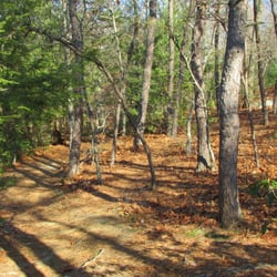
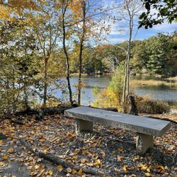
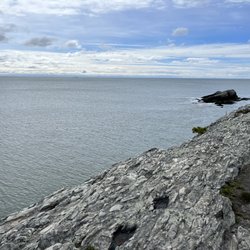
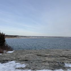
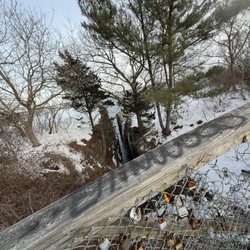
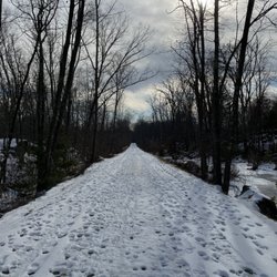
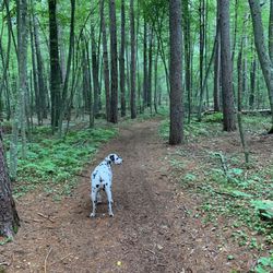
This is a very popular spot for some easy climbing and hiking...a popular hangout for high schoolers as well. Lovely view from the top, the climb is steep but not difficult with wooden rails places up the trail to help with the climb. A few picnic areas with benches, streams and woided and rock trails, unmarked but easy to follow. read more


We wanted to add on a quick nature walk before meeting up at the outlets and this fit the bill. There is a small dirt parking lot with free access to Joe's Rock. The trail itself is not incredibly well-marked, but it's so small that it doesn't matter much. You have the option of taking a steeper shorter climb or a slightly longer roundabout. After you check out the views, you can track upwards next to a neighboring apple farm, which was kind of fun to see in the early fall. Eventually you hit private residential properties in either direction. Probably can't spend more than an hour total walking around here. read more
7 years ago
More info about Joe's Rock
West St
Wrentham, MA 02093
Directions
Hours
Outdoor Amenities
You might also consider


Joe's Rock - hiking - Updated July 2026
Best of Wrentham
People found Joe's Rock by searching for…
Things to Do in Wrentham, Massachusetts
Walking Trails in Wrentham, Massachusetts
Picnic Areas in Wrentham, Massachusetts
Climbing in Wrentham, Massachusetts
Hiking Trails in Wrentham, Massachusetts
Places to Take Pictures in Wrentham, Massachusetts
Public Running Track in Wrentham, Massachusetts
Photo Spots in Wrentham, Massachusetts
Dog Swimming in Wrentham, Massachusetts
Beautiful Views in Wrentham, Massachusetts
Bike Paths in Wrentham, Massachusetts
Scenic Drive in Wrentham, Massachusetts
Waterfalls in Wrentham, Massachusetts
Scenic View in Wrentham, Massachusetts
Dog Walking Areas in Wrentham, Massachusetts
Park With BBQ Pits in Wrentham, Massachusetts
Outdoor Gym in Wrentham, Massachusetts
Easy Hikes in Wrentham, Massachusetts
Parks for Picnics in Wrentham, Massachusetts
Dog Friendly Trails in Wrentham, Massachusetts
Fun Things to Do With Teens in Wrentham, Massachusetts
Stroller Friendly Hikes in Wrentham, Massachusetts
Trending Searches in Wrentham, MA
4th Of July Fireworks near Joe's Rock
Baseball Fields near Joe's Rock
Black Owned Nail Salons near Joe's Rock
Dog Friendly Beaches near Joe's Rock
Dog Friendly Trails near Joe's Rock
Jet Ski Rental near Joe's Rock
Outdoor Activities near Joe's Rock
Outdoor Basketball Courts near Joe's Rock
Parks For Picnics near Joe's Rock
Places To Walk Around near Joe's Rock
Public Beaches near Joe's Rock
River Swimming near Joe's Rock
Scenic Night View near Joe's Rock
Scenic Overlook near Joe's Rock
Secluded Spots near Joe's Rock
Strawberry Picking near Joe's Rock
Swimming Holes near Joe's Rock
Swimming Lakes near Joe's Rock
Things To Do With Kids near Joe's Rock
View Fireworks near Joe's Rock
Browse Nearby
BEST of Wrentham, Massachusetts Restaurants near Joe's Rock
BEST of Wrentham, Massachusetts Coffee near Joe's Rock
BEST of Wrentham, Massachusetts Things to Do near Joe's Rock
BEST of Wrentham, Massachusetts Breakfast near Joe's Rock
BEST of Wrentham, Massachusetts Wineries near Joe's Rock
BEST of Wrentham, Massachusetts Campgrounds near Joe's Rock
BEST of Wrentham, Massachusetts Thrift Stores near Joe's Rock
Browse Brands
Related Searches in Wrentham, MA
Affordable Kayak Rental Services in Wrentham, Massachusetts
Best Fishing Locations and Guides in Wrentham, Massachusetts
Best Gymnastics for Kids Activities in Wrentham, Massachusetts
Best Nature Trails for Hiking in Wrentham, Massachusetts
Best Off Leash Dog Parks in Wrentham, Massachusetts
Best Parks for Parties and Events in Wrentham, Massachusetts
Best Places for Horseback Riding in Wrentham, Massachusetts
Best Rock Climbing Gyms to Try in Wrentham, Massachusetts
Best Spinning Classes Offered in Wrentham, Massachusetts
Best Water Parks for Kids in Wrentham, Massachusetts
Best Waterfalls and Swimming Holes in Wrentham, Massachusetts
Challenge Yourself With an Obstacle Course in Wrentham, Massachusetts
Check Out Great Playgrounds in Wrentham, Massachusetts
Check Out Off Road Trails in Wrentham, Massachusetts
Discover Baseball Fields Around Wrentham, Massachusetts
Discover Beautiful Garden Spots in Wrentham, Massachusetts
Discover Dog Friendly Trails to Explore in Wrentham, Massachusetts
Discover Free Parking Options in Wrentham, Massachusetts
Discover Fun Toddler Parks in Wrentham, Massachusetts for Your Little One
Discover Great Fitness Classes Available in Wrentham, Massachusetts
Discover Kid Friendly Hiking Trails in Wrentham, Massachusetts
Discover Kids Yoga Classes Near Wrentham, Massachusetts
Discover Lakes & Ponds to Explore in Wrentham, Massachusetts
Discover Outdoor Gym Facilities in Wrentham, Massachusetts
Discover Popular Photo Spots in Wrentham, Massachusetts
Discover Popular Ropes Course Options in Wrentham, Massachusetts
Discover Powerlifting Gym Near Wrentham, Massachusetts
Discover Rock Climbing Walls in Wrentham, Massachusetts
Discover Scenic Mountain Bike Trails Near Wrentham, Massachusetts
Discover Soccer Fields in Wrentham, Massachusetts Near You
Discover Top State Parks to Visit in Wrentham, Massachusetts
Discover Top Yoga Options and Studios in Wrentham, Massachusetts
Discover a Hiking Trail in Wrentham, Massachusetts
Discover the Best Beaches in Wrentham, Massachusetts
Discover the Best Kids Park Spots in Wrentham, Massachusetts
Discover the Best Night Hike Trails in Wrentham, Massachusetts
Effective Strength Training Near Wrentham, Massachusetts
Enjoy Camping Adventures Around Wrentham, Massachusetts
Enjoy Exciting Mountain Biking Adventures in Wrentham, Massachusetts
Enjoy Kayaking Adventures in Wrentham, Massachusetts
Enjoy Tent Camping Spots Around Wrentham, Massachusetts
Enjoy a Beautiful Waterfall Hike in Wrentham, Massachusetts
Enjoy the Best Bouldering Experiences in Wrentham, Massachusetts
Enjoy the Best Picnic Spots and Ideas in Wrentham, Massachusetts
Enjoy the Best Walking Path in Wrentham, Massachusetts
Enjoy the Best Walking Trails in Wrentham, Massachusetts
Exciting Cliff Jumping Spots in Wrentham, Massachusetts
Experience Aerial Yoga Sessions in Wrentham, Massachusetts
Explore Beautiful Botanical Gardens in Wrentham, Massachusetts
Explore Beautiful Parks and Green Spaces in Wrentham, Massachusetts
Browse Articles
People who viewed Joe's Rock also viewed
Blackstone River Bikeway
55 reviews
The Monastery Park
12 reviews
Diamond Hill State Park
15 reviews
Purgatory Chasm State Reservation
111 reviews
Lincoln Jogging and Fitness Trail
2 reviews
Powder Mill Ledges Wildlife Refuge
13 reviews
Fort Nature Refuge
4 reviews
Blackall Family And Ballou Farm Preserve
1 review
Pulaski State Park & Recreational Area
1 review
Chase Farm
56 reviews