Ewoldsen Trail Photos


More like Ewoldsen Trail
Recommended Reviews - Ewoldsen Trail
Start your review...

Reviews With Photos

I judge difficulty and coolness of hikes on three things. 1) Do I get a good climb? 2) Do I feel, at any point, that I may need a Satphone or compass? 3) Is there a decent reward along the way or at the top/end? 1) This is a mostly gradual climb up to 1600 feet. There are very few flat parts but there are also very few crazy climbs. The trail itself is is about 4.5-5 miles so about 2 miles uphill was pretty good for me. At times my bum, quads, and calves were burning (if you are doing that "drive through the heel" banging booty move) and I definitely broke a sweat. 2) I am the worst when it comes to planning and am impatient. I got so excited to see the trees, fallen trees, babbling brooks, and bridges that I didn't quite pay attention to which trail we were on and defaulted to following the trail people. As we continued to ascend, the crowds of trail people thinned. We saw more people coming down on the same trail we were climbing. Is this a loop or just a climb???? We saw some same people twice...I started to worry that my memory failed me and had a bit of a Satphone moment. But, this trail is, indeed a loop! We kept going to......... 3) The reward!!! You will see the unobstructed ocean view provided to you by the ridge along Highway 1. For me, the climb and time was totally worth it! Sometimes a hike can be a bit of a wasted workout for me. Not this one! After about 50 sweaty minutes to get up, 40 minutes to get down, and lots of pics we were happy. After some investigation we found that we took a left when we got to the Ewoldsen Loop sign (I was distracted by the bridge that is on the left of that sign). There were 2 fallen trees on the 1/3/15. Nothing that is not manageable but you may need to use one as a "rope" to get around and back on the trail. Don't be afraid to park along Highway 1 because this park has a small parking lot. Happy Hiking Ya'll!

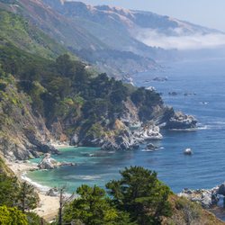
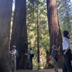
Ewoldsen doesn't have the celebrity status of it's sister trail, McWay Waterfall Overlook Trail, but this Julia Pfieffer Burns trail offers a first-rate hiking experience with beautiful scenery, varying microclimates and some great cardio challenges. Pfieffer Burns Park boasts 5 trails (McWay, Canyon, Tan Bark, Partington and Ewoldsen), each offering a pleasurable experience. To get to Ewoldsen, go away from the ocean towards the east side of the park, right after the restrooms. This hike definitely gets the heart rate going and the gams a workout. Round trip from the parking lot up to the top (via the Waters Trail), around the loop and back to the start is about 5 miles. There are definitely a few challenging rises/climbs as you ascend toward the top. Be sure to take breaks (if you need) to rest and enjoy all the wonderful scenery. The hike takes your through a few gurgling creeks, vast groves, towering redwoods, lush green forests, several bridges and giant rock formations. This hike is really nice because the trees provide a lot of cover and create a nice canopy as you make your way up to the top. If you're wondering where the peak is, keep climbing until you reach a sign marked Waters Trail. This will take you straight up to the expansive views. Unfortunately, we were met with a thick blanket of fog that shrouded the ocean. Still quite a nice view of the hillsides, trees and canyons. There's an overlook bench up here to relax and soak in all the surroundings. Bring some water, light snacks and sunscreen in a small daypack. There are also several picnic areas with bbq pits at the entrance to enjoy a creekside-picnic. Check out the Ewoldsen Trail to experience a rewarding and inspiring sampling of Big Sur.

This trail is difficult, hard, challenging, taunting, etc. Now I'll continue. A few Saturdays ago I came with a group of people for a day hike and I must say that I did not know what I was in store for. I read the reviews, did a google search, and still had no idea how hard this was going to be. At least 4.5 miles uphill with steep, narrow and curvy paths, where at some parts you could potentially slip and fall to your demise. No joke. This is an extremely beautiful trail in an untouched environment that is simply breathtaking. If you're by yourself you can totally zone out with your headphones on, or if with a group it's nice so you can chat to pass the time. Anyone is capable of conquering this trail - heavyset, old, young, etc. and once you've completed, you'll feel amazing. Other notes: - Wear sneakers with great traction as some parts are slippery. - Bring plenty of water and sunscreen. - Get there earlier (by 10am) to be able to park in the lot. - People on the trail are super friendly. - Take your time while hiking and let people pass you. - No signal. Take pics and keep it moving. You can upload later.

A top-notch moderate trail. Well-maintained and clearly marked with a gorgeous variety of views and scenery. You can park in the state park lot for $10 if you're of that persuasion; however, street parking is free! The entrance to the hike is at the far east end of the parking lot, so if you park on the street you'll want to make your way on foot down the driveway to the main state park entrance (the driveway is just slightly down the road and across from the trail that leads to the famous waterfall overlook). You'll stay on the main trail for the most part until you get to a fork about a mile in. Going counterclockwise at the fork probably provides the most stunning views - most of your hard uphill part will be in the redwoods while at the top and going downhill you'll have incredible, expansive coastal views. The hike has beautiful coastal redwoods, oak trees and meadows at the top, and miles of coastal seascapes. Overall the hike is definitely a solid 5 miles and a bit of a workout given the significant uphill portion; not good for kids unless you want to carry them, out of shape people or people with poor footing, or whiny people. Would love to try this during sunset!

Breathtakingly beautiful. This trail was everything I expected, and more. I'm still a bit doubtful on the total length of the trail because online it says that it is a 4.5 mile hike, round trip. However, it definitely felt a lot longer than 4.5 miles. The trail is described as moderate to difficult, I'd like to just point on that it's straight up difficult. As soon as the trail starts, you're hitting inclines that just seem never ending. However, it's the surroundings that make this trail worth the hike. Imagine yourself in a forest, with tall redwoods looming overhead. That's exactly the ambiance of this hike. There are a lot of fallen redwoods on this trail, and it's so perfectly fallen that it crosses streams and rivers. If you aren't afraid of heights like I am, then they're really great photo ops. There are several bridges made to cross streams of waters on the trail and again, also great photo ops. It's a loop, so once you hit a fork in the road, you have the choice of either going left or going right. We overheard a group before us tell us to take a left at the fork, so that's what we did and much to our surprise, the inclines only got harder. This is definitely not a hike for beginners or elderly folks. No matter which way you go, it'll take you up to an open peak where you're able to gaze down below you and see Highway 1, as well as the beautiful and vast ocean. I'd say that the view was worth the pain. You get to see the beautifully blue waters while surrounded by luscious green trees. Please, if you're going to try and hike this trail during the winter, plan for enough time before the sun sets, otherwise you're going to be hiking down in the darkness and it is not safe at all. The trail is ridden with roots, tree branches, stumps, and rocks eroding from the ground. If you can't see where you're going, it is very likely that you'll trip on one of these following things and fall to your death. The trail and walkway is very very VERY narrow, so you definitely want to be cautious while hiking this trail. Another thing is, if you time it just right, and you finish up your hike just as the sun is starting to set, make your way over to the Mcway Falls trail. It's about half a mile and totally beautiful. You'll get to see the small waterfall on the beach, and it's typically filled with people taking pics of the falls from all different angles. And for the best photo op, catch it while the sun is setting :) Everyone you meet is super nice,and they'll greet you with smiles and hellos. So bring your best and just enjoy it. :) Super awesome day hike, and totally worth the drive because there are so many places you can stop at along the way to take photos of the beautiful, blue, ocean. There is absolutely no signal or connection of any sort, so it's definitely a nice getaway from the distractions of the technological world. Parking is $10 if you can find any inside the park itself. If you can't, then your best best is trying to park alongside Highway 1. You'll want to keep your car inside the white lines on the side, because otherwise you'll get a hefty parking ticket of $100 from the park rangers. We witnessed two cars get ticketed because they were parked right at the stop sign...even though they were pulled in all the way. Just be careful!

Ewoldson was such an amazing hiking trail. As I pulled in along with the group I was hiking with, we noticed the parking lot was full and being told by the park rangers that we can also park out in the road if we wanted too at zero cost. So we parked out in the road and walked in, which wasn't far at all. Befor you start the hike, there are some bathrooms on the left side of the road (no bathrooms out in the hike) the trail starts off with a good chalanging climb. The trail is maintained pretty good but has a couple obstacles to deal with, there were a couple trees down that you had to climb under, around or over. If your short on time for your hike, I would recommend you go left at the fork to enjoy the ocean views then head back the same way. If you have plenty time, make sure you go all the way around and complete the circle. Bring plenty of water and some snacks. I did not see any dangerous animals during my hike, plus there is plenty of other hikers around during the day. If you plan to hike late in the day, make sure you take a flashlight just incase it gets dark before you make it back to your vehicle. I will gladly come back again. HAPPY HIKING

Yet another hike to add to my list of adventurist accomplishments! This hike was surprisingly hard and made me sore the next day. I think I hiked a total of 9miles that day. Some parts are shady and not so bad, but there are long sunny stretches that were really steep. It's a big loop without much of a view (but still worth it if you want a good leg workout I guess?) I got a couple mosquito bites whenever I stopped for a break... So hike at a good pace and don't stand still for long! If you're looking for something with a nice view like I was, I suggest toughing it out and hiking Andrew Molera Loop instead. I hear that one leads you to the beach coast. Other Things To See: -McWay Falls: it shares the same parking lot as the Ewoldsen Trail. -Cafe and Art Gallery: interesting pieces... You'll see when you get there.

This is a great hike. Redwoods, the flowing stream, stunning ocean views, huge tree trunks that have fallen down to make impromptu bridges?! This hike is right out of a movie. It starts out fairly basic, just wandering through the trees and stream--bumps up to more of a dirt path that's a steady windy incline for quite a while--turns into a beautiful top of the mountain, "I can see the ocean and highway1 from here!" hike--then winds past a ton of flowers and back into redwoods. When we went (May 2014) the last part of this hike (the part that turns it into a loop) was blocked off and we had to turn around and take the same path back. I think they're clearing off the trails of old dead trees. It's a great hike. Challenging but not too rough, hot but not blistering and the views are more than worth it. As with every hike, bring water, healthy easy snacks and comfortable shoes. ALSO there were quite a few bees so bring an EPI pen if you need it cuz you're definitely isolated up there in the redwoods. Happy hiking!

Tons of blue skies above and below... amazing trail but I suspect that's a well-known 'secret' already; there were quite a few hikers here on a Wednesday morning in February. It's in Julia Pfeiffer Burns SP - not the same as Pfeiffer-Big Sur SP. Bring $10/car and don't expect the entry booth to be manned. Or else, if you're early enough, park on the opposite side of the highway and cross it to get into the park (trailhead is not far). Also: be prepared to shed layers as you climb from the parking lot to about 1500 ft. Parts of the trail are overlooking the ocean and exposed to the sun, so you will need sunblock. Good shoes can prove quite useful in the spring when the path is a bit more wet and slippery. Hans Ewoldsen, a former ranch foreman and resident of Big Sur (at least he was in the '90s), rebuilt this trail in 1933 from an old logging trail. I bought a blue spruce sapling from Home Depot over Christmas and replanted it here on the trail. I hope it survives among the huge redwoods. I got the coordinates and will be visiting again in 2-3 months. ... fingers crossed!

Nice trail easy to follow but for some may not be an easy hike because it's a climb up for the coastal views before returning - it's a loop. But the climb up is assisted my the great redwoods which provide shade and shelter. Big Sur is also higher in altitude so it's cooler as well. The hike from the tunnel off the Highway 1 is probably 7 miles- so pack a lunch, snacks, water. It wasn't as crowded as I thought or people do the shorter trails. Julia Pfeiffer state park is a treasure in Big Sur.

2 years ago
The hike kicked our ass, a lot to adventure and see. I think in total we had almost 15,000 steps and climbed about 109 stairs. read more


Come here if you want to feel like katniss, the part before she volunteered as a tribute and spent most of her days hunting in the woods. This hike is no joke. Beware of bringing noobs on this hike because Ewoldsen will work you so hard and so good. In addition to being steep as hell, the trail is also narrow af. You have to basically hug the wall of the mountain to let the opposite traffic go. Sharing is caring! But be very careful because doing that stunt gets even scarier the higher you go up. The trail starts off only one path in the beginning. Right at the beginning, it's okay to take it a little bit easy. It's very chill at this point. And then suddenly, you face this "almost vertical looking" path and you're thinking to yourself "aw shit. What did I get myself into." But it's too late to turn back. I mean, you can but you traveled so far just to conquer this monster Ewoldsen. You might as well finish it and show off what you achieved! Anyway, somewhere along the trail, a wild fork appears. Which one to take? Left or right?? Choose wisely because one leads you to a never ending path! Just kidding. (Although, you may start thinking that about the entire hike). Per advice from people in the opposite traffic, My friends and I chose left. We really should have went right so that we went counter clockwise because then we would be climbing up less. I don't know if that made sense. We went left. And we ended up going up steep hills so if we had went right, we would be actually going down those hills instead of up. It's actually a loop so technically it doesn't matter if you choose left or right. You will end up at the same fork after completing the loop. The view on the top was stunning. Although, the McWay falls trail produced a prettier picture, you will feel more accomplished once you see the small waterfall from all the way on top of the ewoldsen loop. read more

10 years ago
The Ewoldsen Trail is a loop in the Julia Pfeiffer Burns State Park but to get there is a moderate to difficult trail to get up to the start of the trail called the Canyon Trail which starts at the parking lot. When you get to the end of the Canyon Trail, you'll see a bridge over the creek and another small little sign that goes up to the right. This is the start and end of the loop. P A R K I N G Parking within the park is $10, but you can park along Highway 1 for free, just make sure you stay behind the white lines. It's not a bad little walk from Highway 1 to the start of the trail. R E S T R O O M S There aren't any restrooms on the trail so make sure you go at the parking lot where there is a restroom. Fairly clean as state park restroom goes. T R A I L The loop itself goes up...up up up...it's definitely challenging but not as challenging as Mission Peak since, if you go counter-clockwise, you'll be at least shaded by the trees and even in the areas where it's uncovered, there are patches of trees to take breaks under. If you go clockwise, you'll have a large uncovered path and you'll be a little sorry you went that way especially if it's a sunny day. Also by going counter-clockwise you'll have a lovely view of the ocean while you're going down and back to the start of the trail. Don't forget to go take the Waters Trail to the Overlook Trail as there's a lovely view from the top. You've already come this far, you might as well suck it up and head up a little more. Take your break up there and just soak in all the hard hiking you've done. One thing to make note of is...this is nature, so make sure you be careful in what you touch or what you sit on. We got to the point of the Waters Trail and my boyfriend sat down on a log and realized that it was covered with ants. I've also read stories about ticks and such so if you want to be on the safe side, use some bug spray. We were ok as we were pretty much covered head to toe just ended up sweating a ton. O V E R A L L This is a HARD moderate trail. So if you're not used to hiking gradual to steep inclines for a solid 2.5 miles, then you'll definitely take over 3 hours to do this hike. We did the whole thing in about 2-2.25 hours as we did take some time to take photos and such. I'm fairly active and this was a heart ticker for me so just make sure you bring water, dress accordingly, don't be a hero and take as many breaks as you need as well as bring snacks just in case you do get hungry. read more


10 years ago
I judge difficulty and coolness of hikes on three things. 1) Do I get a good climb? 2) Do I feel, at any point, that I may need a Satphone or compass? 3) Is there a decent reward along the way or at the top/end? 1) This is a mostly gradual climb up to 1600 feet. There are very few flat parts but there are also very few crazy climbs. The trail itself is is about 4.5-5 miles so about 2 miles uphill was pretty good for me. At times my bum, quads, and calves were burning (if you are doing that "drive through the heel" banging booty move) and I definitely broke a sweat. 2) I am the worst when it comes to planning and am impatient. I got so excited to see the trees, fallen trees, babbling brooks, and bridges that I didn't quite pay attention to which trail we were on and defaulted to following the trail people. As we continued to ascend, the crowds of trail people thinned. We saw more people coming down on the same trail we were climbing. Is this a loop or just a climb???? We saw some same people twice...I started to worry that my memory failed me and had a bit of a Satphone moment. But, this trail is, indeed a loop! We kept going to......... 3) The reward!!! You will see the unobstructed ocean view provided to you by the ridge along Highway 1. For me, the climb and time was totally worth it! Sometimes a hike can be a bit of a wasted workout for me. Not this one! After about 50 sweaty minutes to get up, 40 minutes to get down, and lots of pics we were happy. After some investigation we found that we took a left when we got to the Ewoldsen Loop sign (I was distracted by the bridge that is on the left of that sign). There were 2 fallen trees on the 1/3/15. Nothing that is not manageable but you may need to use one as a "rope" to get around and back on the trail. Don't be afraid to park along Highway 1 because this park has a small parking lot. Happy Hiking Ya'll! read more


Ewoldsen doesn't have the celebrity status of it's sister trail, McWay Waterfall Overlook Trail, but this Julia Pfieffer Burns trail offers a first-rate hiking experience with beautiful scenery, varying microclimates and some great cardio challenges. Pfieffer Burns Park boasts 5 trails (McWay, Canyon, Tan Bark, Partington and Ewoldsen), each offering a pleasurable experience. To get to Ewoldsen, go away from the ocean towards the east side of the park, right after the restrooms. This hike definitely gets the heart rate going and the gams a workout. Round trip from the parking lot up to the top (via the Waters Trail), around the loop and back to the start is about 5 miles. There are definitely a few challenging rises/climbs as you ascend toward the top. Be sure to take breaks (if you need) to rest and enjoy all the wonderful scenery. The hike takes your through a few gurgling creeks, vast groves, towering redwoods, lush green forests, several bridges and giant rock formations. This hike is really nice because the trees provide a lot of cover and create a nice canopy as you make your way up to the top. If you're wondering where the peak is, keep climbing until you reach a sign marked Waters Trail. This will take you straight up to the expansive views. Unfortunately, we were met with a thick blanket of fog that shrouded the ocean. Still quite a nice view of the hillsides, trees and canyons. There's an overlook bench up here to relax and soak in all the surroundings. Bring some water, light snacks and sunscreen in a small daypack. There are also several picnic areas with bbq pits at the entrance to enjoy a creekside-picnic. Check out the Ewoldsen Trail to experience a rewarding and inspiring sampling of Big Sur. read more


This trail is difficult, hard, challenging, taunting, etc. Now I'll continue. A few Saturdays ago I came with a group of people for a day hike and I must say that I did not know what I was in store for. I read the reviews, did a google search, and still had no idea how hard this was going to be. At least 4.5 miles uphill with steep, narrow and curvy paths, where at some parts you could potentially slip and fall to your demise. No joke. This is an extremely beautiful trail in an untouched environment that is simply breathtaking. If you're by yourself you can totally zone out with your headphones on, or if with a group it's nice so you can chat to pass the time. Anyone is capable of conquering this trail - heavyset, old, young, etc. and once you've completed, you'll feel amazing. Other notes: - Wear sneakers with great traction as some parts are slippery. - Bring plenty of water and sunscreen. - Get there earlier (by 10am) to be able to park in the lot. - People on the trail are super friendly. - Take your time while hiking and let people pass you. - No signal. Take pics and keep it moving. You can upload later. read more


A top-notch moderate trail. Well-maintained and clearly marked with a gorgeous variety of views and scenery. You can park in the state park lot for $10 if you're of that persuasion; however, street parking is free! The entrance to the hike is at the far east end of the parking lot, so if you park on the street you'll want to make your way on foot down the driveway to the main state park entrance (the driveway is just slightly down the road and across from the trail that leads to the famous waterfall overlook). You'll stay on the main trail for the most part until you get to a fork about a mile in. Going counterclockwise at the fork probably provides the most stunning views - most of your hard uphill part will be in the redwoods while at the top and going downhill you'll have incredible, expansive coastal views. The hike has beautiful coastal redwoods, oak trees and meadows at the top, and miles of coastal seascapes. Overall the hike is definitely a solid 5 miles and a bit of a workout given the significant uphill portion; not good for kids unless you want to carry them, out of shape people or people with poor footing, or whiny people. Would love to try this during sunset! read more


11 years ago
10 years ago
Breathtakingly beautiful. This trail was everything I expected, and more. I'm still a bit doubtful on the total length of the trail because online it says that it is a 4.5 mile hike, round trip. However, it definitely felt a lot longer than 4.5 miles. The trail is described as moderate to difficult, I'd like to just point on that it's straight up difficult. As soon as the trail starts, you're hitting inclines that just seem never ending. However, it's the surroundings that make this trail worth the hike. Imagine yourself in a forest, with tall redwoods looming overhead. That's exactly the ambiance of this hike. There are a lot of fallen redwoods on this trail, and it's so perfectly fallen that it crosses streams and rivers. If you aren't afraid of heights like I am, then they're really great photo ops. There are several bridges made to cross streams of waters on the trail and again, also great photo ops. It's a loop, so once you hit a fork in the road, you have the choice of either going left or going right. We overheard a group before us tell us to take a left at the fork, so that's what we did and much to our surprise, the inclines only got harder. This is definitely not a hike for beginners or elderly folks. No matter which way you go, it'll take you up to an open peak where you're able to gaze down below you and see Highway 1, as well as the beautiful and vast ocean. I'd say that the view was worth the pain. You get to see the beautifully blue waters while surrounded by luscious green trees. Please, if you're going to try and hike this trail during the winter, plan for enough time before the sun sets, otherwise you're going to be hiking down in the darkness and it is not safe at all. The trail is ridden with roots, tree branches, stumps, and rocks eroding from the ground. If you can't see where you're going, it is very likely that you'll trip on one of these following things and fall to your death. The trail and walkway is very very VERY narrow, so you definitely want to be cautious while hiking this trail. Another thing is, if you time it just right, and you finish up your hike just as the sun is starting to set, make your way over to the Mcway Falls trail. It's about half a mile and totally beautiful. You'll get to see the small waterfall on the beach, and it's typically filled with people taking pics of the falls from all different angles. And for the best photo op, catch it while the sun is setting :) Everyone you meet is super nice,and they'll greet you with smiles and hellos. So bring your best and just enjoy it. :) Super awesome day hike, and totally worth the drive because there are so many places you can stop at along the way to take photos of the beautiful, blue, ocean. There is absolutely no signal or connection of any sort, so it's definitely a nice getaway from the distractions of the technological world. Parking is $10 if you can find any inside the park itself. If you can't, then your best best is trying to park alongside Highway 1. You'll want to keep your car inside the white lines on the side, because otherwise you'll get a hefty parking ticket of $100 from the park rangers. We witnessed two cars get ticketed because they were parked right at the stop sign...even though they were pulled in all the way. Just be careful! read more


Ewoldson was such an amazing hiking trail. As I pulled in along with the group I was hiking with, we noticed the parking lot was full and being told by the park rangers that we can also park out in the road if we wanted too at zero cost. So we parked out in the road and walked in, which wasn't far at all. Befor you start the hike, there are some bathrooms on the left side of the road (no bathrooms out in the hike) the trail starts off with a good chalanging climb. The trail is maintained pretty good but has a couple obstacles to deal with, there were a couple trees down that you had to climb under, around or over. If your short on time for your hike, I would recommend you go left at the fork to enjoy the ocean views then head back the same way. If you have plenty time, make sure you go all the way around and complete the circle. Bring plenty of water and some snacks. I did not see any dangerous animals during my hike, plus there is plenty of other hikers around during the day. If you plan to hike late in the day, make sure you take a flashlight just incase it gets dark before you make it back to your vehicle. I will gladly come back again. HAPPY HIKING read more

 - Hiking Near Me - Big Sur, California")

Yet another hike to add to my list of adventurist accomplishments! This hike was surprisingly hard and made me sore the next day. I think I hiked a total of 9miles that day. Some parts are shady and not so bad, but there are long sunny stretches that were really steep. It's a big loop without much of a view (but still worth it if you want a good leg workout I guess?) I got a couple mosquito bites whenever I stopped for a break... So hike at a good pace and don't stand still for long! If you're looking for something with a nice view like I was, I suggest toughing it out and hiking Andrew Molera Loop instead. I hear that one leads you to the beach coast. Other Things To See: -McWay Falls: it shares the same parking lot as the Ewoldsen Trail. -Cafe and Art Gallery: interesting pieces... You'll see when you get there. read more


12 years ago
This is a great hike. Redwoods, the flowing stream, stunning ocean views, huge tree trunks that have fallen down to make impromptu bridges?! This hike is right out of a movie. It starts out fairly basic, just wandering through the trees and stream--bumps up to more of a dirt path that's a steady windy incline for quite a while--turns into a beautiful top of the mountain, "I can see the ocean and highway1 from here!" hike--then winds past a ton of flowers and back into redwoods. When we went (May 2014) the last part of this hike (the part that turns it into a loop) was blocked off and we had to turn around and take the same path back. I think they're clearing off the trails of old dead trees. It's a great hike. Challenging but not too rough, hot but not blistering and the views are more than worth it. As with every hike, bring water, healthy easy snacks and comfortable shoes. ALSO there were quite a few bees so bring an EPI pen if you need it cuz you're definitely isolated up there in the redwoods. Happy hiking! read more


10 years ago
Tons of blue skies above and below... amazing trail but I suspect that's a well-known 'secret' already; there were quite a few hikers here on a Wednesday morning in February. It's in Julia Pfeiffer Burns SP - not the same as Pfeiffer-Big Sur SP. Bring $10/car and don't expect the entry booth to be manned. Or else, if you're early enough, park on the opposite side of the highway and cross it to get into the park (trailhead is not far). Also: be prepared to shed layers as you climb from the parking lot to about 1500 ft. Parts of the trail are overlooking the ocean and exposed to the sun, so you will need sunblock. Good shoes can prove quite useful in the spring when the path is a bit more wet and slippery. Hans Ewoldsen, a former ranch foreman and resident of Big Sur (at least he was in the '90s), rebuilt this trail in 1933 from an old logging trail. I bought a blue spruce sapling from Home Depot over Christmas and replanted it here on the trail. I hope it survives among the huge redwoods. I got the coordinates and will be visiting again in 2-3 months. ... fingers crossed! read more


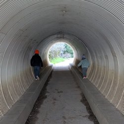
Nice trail easy to follow but for some may not be an easy hike because it's a climb up for the coastal views before returning - it's a loop. But the climb up is assisted my the great redwoods which provide shade and shelter. Big Sur is also higher in altitude so it's cooler as well. The hike from the tunnel off the Highway 1 is probably 7 miles- so pack a lunch, snacks, water. It wasn't as crowded as I thought or people do the shorter trails. Julia Pfeiffer state park is a treasure in Big Sur. read more


12 years ago
10 years ago
8 years ago
12 years ago
12 years ago
10 years ago
10 years ago
This trail is awesome! My husband and I went over to the McWay waterfall first and then the Ewoldsen trail. What my husband and I did not realize is that by staying to the left we missed the entry for the Ewoldsen and ended up at the waterfall; however on our way back we saw the Ewoldsen sign and did the Ewoldsen loop. The hike is amazing! A good elevation gain, but gradual and not too strenuous. The fog rolled in pretty deep along with light rain which made it that much more mysterious and amazing. The only downside was we could not see the ocean through the fog. This place is definitely magical and well worth it!!! I would say if you are in the area this is a must see. We were out on the trail a little over 4 hours or so and stopped after the loop was complete to eat some snacks. Also, we got there around 9 and opted for the street parking since we did not have to pay read more


11 years ago
11 years ago
10 years ago
11 years ago
More info about Ewoldsen Trail
Julia Pfeiffer Burns State Park
Hwy 1
Big Sur, CA 93920
Directions
Hours
Outdoor Amenities
Ask the Community - Ewoldsen Trail
Review Highlights - Ewoldsen Trail


Why does Yelp recommend reviews?
Ewoldsen Trail - hiking - Updated June 2026
Best of Big Sur
People found Ewoldsen Trail by searching for…
Hiking Trails With Waterfalls in Big Sur, California
Things to Do in Big Sur, California
Redwood Trees in Big Sur, California
Beaches in Big Sur, California
Picnic Areas BBQ Pits in Big Sur, California
Stroller Friendly Hikes in Big Sur, California
National Parks in Big Sur, California
Waterfalls and Swimming Holes in Big Sur, California
Stair Climbing in Big Sur, California
Easy Hikes in Big Sur, California
Waterfall in Big Sur, California
Fishing Spots in Big Sur, California
Picnic Spots in Big Sur, California
Photo Spots in Big Sur, California
Secluded Spots in Big Sur, California
Natural Hot Springs in Big Sur, California
Running Trails in Big Sur, California
Secret Spots in Big Sur, California
Swimming Lakes in Big Sur, California
Canyoneering in Big Sur, California