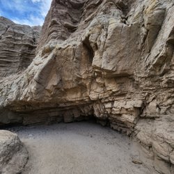
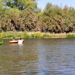
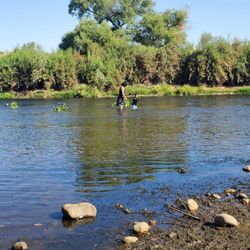
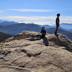
DeAnza Springs Resort Photos


You might also consider
More like DeAnza Springs Resort
Recommended Reviews - DeAnza Springs Resort
Start your review...

Reviews With Photos

I've stayed here before and had a decent experience, so I decided to return for another weekend trip with my family. Unfortunately, the morning of May 31, 2025, completely ruined it -- so much so that I cut our trip short and checked out early. That morning, the woman working on staff made me feel incredibly unwelcome. Her attitude was confrontational, and she seemed to be looking for reasons to single me out. I was with my children and two small dogs (one of which is a service animal), and was doing my best to be respectful and follow the rules. While waiting outside the pool area in the lounge section (as dogs aren't allowed in the gated pool area), I let my dogs relieve themselves, then walked to my car to grab doggie bags. As I was cleaning up, the employee came over and accused me of not picking up after my dogs -- even though I was clearly in the process of doing so. I calmly explained what was happening, but she continued to speak to me in a rude and aggressive way. Soon after, one of my dogs sniffed her as she passed, and she suddenly exclaimed, "Your dog just bit me!" I was right there -- my dog did not bite her, just sniffed her as dogs do. It felt like an overreaction meant to escalate things further. She walked away, then returned yet again to tell me my dogs had to be on leashes. I explained that I was holding both of them in my lap and that they weren't roaming freely -- which is entirely within the rules. She then asked if I even had leashes, which felt unnecessarily accusatory. She also tried to say my dogs weren't allowed in the pool area -- again, they weren't in the pool area. We were sitting clearly outside of it. I had followed all posted rules, yet still found myself being constantly confronted and made to feel like I didn't belong there. Between the false accusations and the overall hostile tone, it became too much. I packed up and left by 9:30 AM that same morning. If you're hoping for a peaceful, pet-friendly stay where you're treated with basic respect, this may not be the place for you.

I started going here in 2011. This was my favorite place to camp, hike and enjoy the peace and serenity that "was" De Anza Springs. New owners started out by cleaning the place up and updating some amenities BUT now they have gone clothing optional-no AANR membership. There are frequent multi day raves. I knew many of the full time members/residents and the whole area had a sense of community. When I went there a few days ago and asked about my membership renewal, I was told "there is no more membership, everyone pays the new rates." And those are pretty pricey new rates. Dry camping (a spot on the ground) $63.00 a night up from $12.00 for members. Full hookups START at $71,00 per night up from $17.00 for members (maybe they just got the numbers backwards?) Now they are one of the more expensive campgrounds. You do not get anything extra for the premium prices they charge and they still can not seem to maintain the pools and spa. When I was there a few days ago, the 2 pools and spa were closed. That was the last time I will go there. If you like raves and don't care for nature but enjoy no sleep, crowds, LOUD electronic dance music, flashing lights, spending money and dust, then bring your mum or dads fat wallet down to De Anza Springs Ravesort (#Ravesort-that's mine) and party on!!!!!

Love this resort, and I've been to DeAnza many times over the past several years, but the recent ownership change and 'clothing optional' policy also changed the vibe. There's a new crowd showing up for the frequent music festivals and they are not nudists. There's no problem, and they have full access to all the facilities, but it's just a a bit strange seeing so many young, clothed people at DeAnza. The established residents don't particularly like it, but it's ok with us. I see recent reviews describing illicit and bad behavior by this new influx of younger, festival attendees. This concerns me, although I did not see any of it happening during the two recent weekends I was there (Memorial weekend and the Heartbeat Retreat Music Festival; and I cannot comment about YouTopia, when supposedly there were 1000 people on the grounds June 7-11). Mostly, everyone (the 20-35-ish crowd) at the Festival were pleasant and fun, although I did hear music playing late into the night in one camp, by a few inconsiderate kids. The organizers sponsored a pool party on the final day, and that was an interesting mix of mature nudists and younger clothed party-goers, that was a lot of fun. The DJ/music was great, and I didn't mind sharing the pool area (we dressed-up and wore skimpy bathing suits, just for something different and fun, see pics). Some of the facilities were recently upgraded by the new owners (mostly in the The Colony festival area), and that's great, but the other areas are the same as recent years...still well-kept, clean and comfortable. Good. Note: The restaurant is only open in the weekends, but it's great food, and the proprietor is outstanding. There's still/always great hiking trails in all directions, no clothing required, and that's still a big plus with us. We love hiking naked in the wilderness. If the new 20-30-ish 'party' crowd is respectful of the long-time DeAnza residents, nudists and resort guests, then it'll still be an enjoyable place to visit, camp and relax in the sun by the pool. We had a good time at the music festival and pool party, and plan on attending a future event.

We've been out several times over the last few years, and the resort keeps getting better! Our first couple visits we stayed in the motel, which was nice and clean but pretty basic. Since then, I know they've redone all the rooms to be much cooler (they have different themes) but we haven't stayed in them yet. Since we have a toddler, the tiny homes have been a better location so we can have access to a fridge and kitchen. I would suggest choosing a tiny house close to the pool/restaurant area if you plan on spending time there so it's a quick walk over. We didn't mind the nudists at the resort, but appreciate that with the rule changes we can now use the pool (couldn't before unless you were also nude.) Unless you plan on leaving the resort to go into town, I'd recommend packing plenty of food/snacks or planning to eat at the restaurant as there isn't really anything else close by. We love it there, and love how we can be "off the grid" with just a short drive from SD. We'll definitely be back!

Resort is a bit of a stretch of the imagination to describe De Anza Springs Resort. To me, it's more of a glorified camp ground. Be prepared to go about a mile on an extremely dusty, bumpy road once you get off the I-8 offramp. So don't wash your car before this trip. Many different ways of staying. I chose a room that was part of a small 6 room motel section, two of the rooms are wheel chair accessible with a ramp & wheel chair friendly shower. The narrow room was clean. Bed comfortable enough. Heater worked well when outdoor night temperatures went down to the upper 30°F's in late November. Price at about $160 per night was expensive considering it is basic accommodation in the middle of nowhere which was fine with me since I value quiet & silence. Close to Jacumba Hot Springs Resort which is rather classy and was my original goal since Jacumba Restaurant Caravan Lounge, where I was dining, was hosting a pop up dinner by noted Chef Brian Redzikowski. After dinner, I got to soak my feet in the heated, curative sulfur spring pool. Unfortunately, the rather large pool at De Anza Springs does not have those healthful sulfur waters. When I called by phone to make a reservation, Patty was very informative telling me: "There is no internet nor phone access at the locked entry gate to the property. So I should receive the new entry code about a day before the reservation date. If not, be sure to contact the main office which closes at 5pm." I assume that if you anticipate getting there after 5pm, it would be recommended to call the office before the 5pm closure to make arrangements for late arrival. De Anza is good for what it is. Basic accommodations that are adequate. Btw, great star gazing for those astronomically inclined. 3 stars read more


3 months ago
Really enjoyed the resort. The people were friendly, there were lots of hiking trails and an awesome hot tub. Bartender was kind and good breakfast. I stayed in one of the motel rooms. It was advertised as having a queen bed but actually had a full. So unfortunately me and my partner didn't get much sleep as a queen is as small as we could do while being comfortable. Also the walls are extremely thin. Next time I think I'll just get a tent spot or maybe one of the rvs that you can stay in. read more

1 year ago
I've stayed here before and had a decent experience, so I decided to return for another weekend trip with my family. Unfortunately, the morning of May 31, 2025, completely ruined it -- so much so that I cut our trip short and checked out early. That morning, the woman working on staff made me feel incredibly unwelcome. Her attitude was confrontational, and she seemed to be looking for reasons to single me out. I was with my children and two small dogs (one of which is a service animal), and was doing my best to be respectful and follow the rules. While waiting outside the pool area in the lounge section (as dogs aren't allowed in the gated pool area), I let my dogs relieve themselves, then walked to my car to grab doggie bags. As I was cleaning up, the employee came over and accused me of not picking up after my dogs -- even though I was clearly in the process of doing so. I calmly explained what was happening, but she continued to speak to me in a rude and aggressive way. Soon after, one of my dogs sniffed her as she passed, and she suddenly exclaimed, "Your dog just bit me!" I was right there -- my dog did not bite her, just sniffed her as dogs do. It felt like an overreaction meant to escalate things further. She walked away, then returned yet again to tell me my dogs had to be on leashes. I explained that I was holding both of them in my lap and that they weren't roaming freely -- which is entirely within the rules. She then asked if I even had leashes, which felt unnecessarily accusatory. She also tried to say my dogs weren't allowed in the pool area -- again, they weren't in the pool area. We were sitting clearly outside of it. I had followed all posted rules, yet still found myself being constantly confronted and made to feel like I didn't belong there. Between the false accusations and the overall hostile tone, it became too much. I packed up and left by 9:30 AM that same morning. If you're hoping for a peaceful, pet-friendly stay where you're treated with basic respect, this may not be the place for you. read more

4 months ago
7 months ago
3 years ago
3 years ago
I started going here in 2011. This was my favorite place to camp, hike and enjoy the peace and serenity that "was" De Anza Springs. New owners started out by cleaning the place up and updating some amenities BUT now they have gone clothing optional-no AANR membership. There are frequent multi day raves. I knew many of the full time members/residents and the whole area had a sense of community. When I went there a few days ago and asked about my membership renewal, I was told "there is no more membership, everyone pays the new rates." And those are pretty pricey new rates. Dry camping (a spot on the ground) $63.00 a night up from $12.00 for members. Full hookups START at $71,00 per night up from $17.00 for members (maybe they just got the numbers backwards?) Now they are one of the more expensive campgrounds. You do not get anything extra for the premium prices they charge and they still can not seem to maintain the pools and spa. When I was there a few days ago, the 2 pools and spa were closed. That was the last time I will go there. If you like raves and don't care for nature but enjoy no sleep, crowds, LOUD electronic dance music, flashing lights, spending money and dust, then bring your mum or dads fat wallet down to De Anza Springs Ravesort (#Ravesort-that's mine) and party on!!!!! read more


3 years ago
Love this resort, and I've been to DeAnza many times over the past several years, but the recent ownership change and 'clothing optional' policy also changed the vibe. There's a new crowd showing up for the frequent music festivals and they are not nudists. There's no problem, and they have full access to all the facilities, but it's just a a bit strange seeing so many young, clothed people at DeAnza. The established residents don't particularly like it, but it's ok with us. I see recent reviews describing illicit and bad behavior by this new influx of younger, festival attendees. This concerns me, although I did not see any of it happening during the two recent weekends I was there (Memorial weekend and the Heartbeat Retreat Music Festival; and I cannot comment about YouTopia, when supposedly there were 1000 people on the grounds June 7-11). Mostly, everyone (the 20-35-ish crowd) at the Festival were pleasant and fun, although I did hear music playing late into the night in one camp, by a few inconsiderate kids. The organizers sponsored a pool party on the final day, and that was an interesting mix of mature nudists and younger clothed party-goers, that was a lot of fun. The DJ/music was great, and I didn't mind sharing the pool area (we dressed-up and wore skimpy bathing suits, just for something different and fun, see pics). Some of the facilities were recently upgraded by the new owners (mostly in the The Colony festival area), and that's great, but the other areas are the same as recent years...still well-kept, clean and comfortable. Good. Note: The restaurant is only open in the weekends, but it's great food, and the proprietor is outstanding. There's still/always great hiking trails in all directions, no clothing required, and that's still a big plus with us. We love hiking naked in the wilderness. If the new 20-30-ish 'party' crowd is respectful of the long-time DeAnza residents, nudists and resort guests, then it'll still be an enjoyable place to visit, camp and relax in the sun by the pool. We had a good time at the music festival and pool party, and plan on attending a future event. read more

 - Hiking Near Me - Jacumba, California")


6 months ago
2 years ago
3 years ago
3 years ago
3 years ago
3 years ago
2 years ago
3 years ago
3 years ago
We've been out several times over the last few years, and the resort keeps getting better! Our first couple visits we stayed in the motel, which was nice and clean but pretty basic. Since then, I know they've redone all the rooms to be much cooler (they have different themes) but we haven't stayed in them yet. Since we have a toddler, the tiny homes have been a better location so we can have access to a fridge and kitchen. I would suggest choosing a tiny house close to the pool/restaurant area if you plan on spending time there so it's a quick walk over. We didn't mind the nudists at the resort, but appreciate that with the rule changes we can now use the pool (couldn't before unless you were also nude.) Unless you plan on leaving the resort to go into town, I'd recommend packing plenty of food/snacks or planning to eat at the restaurant as there isn't really anything else close by. We love it there, and love how we can be "off the grid" with just a short drive from SD. We'll definitely be back! read more


3 years ago
4 years ago
9 years ago
Business owner information
Tyler D.
Thank you, Patricia, this is a great place to be around people of all…
4 years ago
Went to a Reggae festival last weekend that was awesome. I know it may feel intimidating or strange to visit a clothing optional resort.. but once you get there you feel at ease. We did not "go nude" but everyone was still welcoming and very friendly. Beautiful views, breathtaking hiking, modern bar, great food at the restaurant and definitely a must visit SD spot! Awesome photo o read more


3 years ago
We spent a long weekend here and it was fantastic. Due to the heat, we spent most of the time at the pools, indoor and outdoor. Our friends rented a pet-friendly RV but we stayed at their hotel. The hotel was clean, air conditioned and comes equipped with small fridge & microwave. We didn't eat at the restaurant, we brought a lot food and cooked it on our friend's Trager grill or inside their 5th-wheel. Since we tend to overdue everything, we brought it all down to the common area patio and shared with other guests. The best part of our stay was the warm welcome we received from the other visitors, permanent residents and everyone who worked here. If you have never been to a clothing optional resort, this is a good place to start. I cannot stress enough how comfortable an environment it is, "non-judgmental" is the word everyone used. The pools & hot tub have the no clothing rule but other areas people are dressed or undressed in whatever they are comfortable in. From our most recent experience, going during one of their event weekends wasn't that great. We paid for our hotel, the daily membership fee, then we were charged $65 a piece for the event. There were supposed to be 3 days of bands and vendors. I think one or more of the bands didn't show, there was one great vendor doing henna and massages but not much else, so it really wasn't worth the fees. I'd rather just spend the money in their bar or tipping the guy selling those awesome frozen margaritas by the pool and having their awesome DJ Richie play music. The best part of our stay was taking a vacation away from our cell phones and computers. I've never slept so well as I did those 4 days. The sunsets are breathtaking and the night sky is full of stars. If you venture out, you may encounter bunnies, bats, tarantulas, snakes~ nothing too scary. This is a peaceful resort and we can't wait for our next visit! read more


Business owner information
Tyler D.
Thank you, Susana, we like to hear that our guests are happy. We are…
6 years ago
5 years ago
Great Stay! We read mixed reviews and took a chance and went to DeAnza Springs Resort. We are so happy we did! From checking in with Kim (who is also the bartender) to the room, to the property and the hiking trails. It was all amazing. So much better than we were expecting! The cafe was okay, the selection was limited. But chef Darrel was so friendly, personable and a great cook! We wished the cafe are the bar were open for dinner Sunday, but it didn't really impact our stay. Behind the bar Kim was awesome! She remembered our names and our drinks for our entire stay. Kim also hooked us up with the best hiking trails. Everyone we encountered that worked at the resort was great, but Kim and Darrel really made our vacation more enjoyable!! The hiking trail map we got from the front desk is wildly unreadable, and desperately needs to be redone. (That was our biggest complaint.) Fortunately, the residents are super nice and friendly. They gave us lots of places to hike, and suggestions for local dining off property. Everyone we met was easy to talk too and very inviting. My wife mentioned several times how comfortable she felt moving about the property and lounging by the pool. (Meaning no pervy men leering, trying to talk to her or hanging around.). This is very important to us. Overall, we had a great trip and highly recommend this property for families, couples and single women. We are looking forward to returning and hitting the hiking trails we missed. read more


8 years ago
Business owner information
Tyler D.
Thank you. But just a heads up the railroad has started ticketing…
5 years ago
Great place to get rid of the unsightly tan lines , it took me one visit before I realized that this is where I need to be , great people and place all around read more


3 years ago
During recent festival, karnival of the arts, I personally witnessed open sex acts, open drug use and unsanitary pool conditions. I went to the office 4x in 24 hours to make them aware of what's happening as this was at the time an AANR park (nudist organization) and offensive behavior. Only once did anyone come out of the office to confront a couple nearly having penatrative sex on pool lounge chair. The office manager sent her husband out to route the quests back to their campsite to finish I assume what they started. I wrote the owner a letter and meet with him and my wife. He didn't address the issues but did make a lot of excuses about how the park was learning, can't afford security and effectively if we didn't like the new direction we should GTFO in a nice covertly hostel way. At the recent labor day weekend pool party the other owner KC was the guest dj. His play list included a song whose lyrics glorified inappropriate touching of children. At the time there were 8 families with children listening on the pool deck. See photo below. . IF YOU ARE INTERESTED IN STAYING HERE, BUYING AN IMPROVED SPOT OR RENTING DIG DEEPER. MAKE YOUR OWN OPINION BUT BE INFORMED. With a degree in marketing and creative use of photoshop the images on the net and vibe don't match reality. There is a very hostal environment from management and most residents in attendance at most recent townhall meeting. My wife and I can no longer support and are leaving this facility. read more

3 years ago
3 years ago
5 years ago
I love this place! From the hiking to the food it's a great place to relax and let the stress of the city life fall off your shoulders. Lots of great places to explore. Temple Peak has an energy you can feel when your up close. I recommend this place to anyone looking for something a little different. The sleeping accommodations are nice and the people are friendly! read more


5 years ago
6 years ago
6 years ago
We unfortunately missed a chance to stay here because online reviews gave us the impression that it was under construction and all of the facilities were closed. We stopped by to see for ourselves and will definitely return on a future trip. It is essentially a large RV park in a spectacular setting in a bowl surrounded by low mountains. They have a number of park models available to rent, or you can bring your own rig. There's also a very large common area, with a library/game room, a cafe and a restaurant. Laundry facilities and wifi are available onsite. It's not a fancy "spa" by any means, but looks comfy enough and the prices are very reasonable for California. Being able to hike from camp is very appealing. Winter may not be the best time to visit -- the large pool is 85 degrees and the single hot tub is 102 -- but we look forward to staying here on a future trip to Anza Borrego. read more


7 years ago
5 years ago
7 years ago
17 years ago
Being that I'm no stranger to the nude beaches of Blacks and San O, I decided to take it up a notch and check out a nudist resort. It wasnt really the resort I wanted to check out but the miles of nude hiking available there. As I reached the entrance to the resort, I was presented with a closed gate that I had to buzz in for. Bzzzzzzz. "Main Office, How can I help you?". "I'd like to check out the resort with my 1 day pass for new visitors". "Ok, see you at the front office" Gates open and I drive in. The resort resembles desert campgrounds with several mobile homes, RV's, shacks, lining the seemingly unorganized maze of dirt roads. Not as developed as I imagined it. I thought it would be like a mobile home community setup for some reason. Don't get me wrong, that's what was stuck in my head. Overall, its a nice place. Driving to the main office, I passed several people whom surprisingly were not FULLY nude. Again my miconception about how nudists were. I arrived to the main office to check in, ahhh, here is the meat and potatoes of the resort! Nude, semi clothed, and clothed people were entering/exiting the main building. As I entered the front door ALOT more nude people here just acting normal. I walk up to the front desk and was greeted by 2 nice women with smiles. They were clothed, probably to interact with visitors, vendors, and the like and keep them at a comfortable level. I tell them this is my first time here and one of the ladies responds "Oh you're a Virgin!!" Yep. They collect some information about me and I am greeted by another friendly lady to give me a tour. I was not asked to remove my clothes for the tour which again, i thought I might have had to. They show me the lounge areas, cafeteria, dance hall, the 2 pools (1 heated the other not), and the spa. The poeple that were in the clubhouse were mostly older men, a few older women, and 1 or 2 minors. After the tour, Im off to do whatever I please... So I head out for some nude hiking before it gets too hot. Get to what I think is the one of the trailheads and begin stripping down to prep myslef for some nude Hiking. Hat- check, sunblock - check, snacks - check, knife - check (just in case I meet some unfriendly furry friends), Water - check, extra water - check, gatorade - check, shorts - I think I'll just leave em in the car. MMkay I think Im ready to go. So Im standing on the trail head and Im trying to find my path. I can only follow each path so far until its greeted with rocks upon boulder upon rock and more boulders. Ok.. so its this kind of hiking. I start my acsent and once I get high enough , I find that there was an easier way in about a few hundred yards from where I parked. Aw @#*&! Oh well, this way was fun too. The trails are surrounded by your typical desert furniture; Cactus, sand, the brush that has those little spears that always get into your socks, and tons of rocks. Its a great feeling to be walking around nude out in the open just watch out for all the hazards. After I reach the top the terrain flattens out and there is a slight downhill trek I had to make and eventually a wash I can follow. Its beautiful scenery if you can appreciate desert landscape. Its also dead silent except for the noise that you make when you walk. I wasnt sure where I shouldve went to see the best these trails had to offer. I just wanted to test it out first. BTW, please let me know where these spot are so I can map it out on my next trip. After walking a few miles or so and taking pics along the way, I check my water levels and decide I should begin heading back. I take the "easier" route back which still required a little boulder traversing and decide to take a few breathers under some nice shaded holes created by the boulders leaning up on one another. Once I got back to where I started, I just decided to "Cool down" by just taking my time a walking to the clubhouse from the trail head (about couple hundred yards). Head back through the main office and head straight to the showers (mmm cold showers). I just realized then that another benefit of the nudist resort is that I didnt need to bring any clothes to the shower and I could just air dry off while I continue to cool down. At this time there was alot more people in the club house than before. More men, AND more women, all going about their regular business, conversations, whatever. One thing I did notice is that for the time I went there. I did not see any minorities, no black people,Mexican people, asian.. .nothing. At the nude beaches, you see all kinds of different backgrounds. I guess resorts are a different story. Its wasnt a problem that I was the only minority just an observation. Everyone seemed to be friendly and helpful whenever I talked with them. Its just like being around regular textiles.. just without clothes which you dont even realize after a while. read more


16 years ago
Page 1 of 2
More info about DeAnza Springs Resort
1951 Carrizo Gorge Rd
Jacumba, CA 91934
Directions
(619) 766-4301
Call Now
Visit Website
https://www.deanzasprings.com
Hours
Indoor Amenities
Outdoor Amenities
Other Amenities
From the Business
Ask the Community - DeAnza Springs Resort
Family friendly? I have a 11 yo son and 13 yo daughter and her friend, can I take them?
You can bring your children but non-related minors would need to be accompanied by their parent or guardian. Double check with management but that is standard policy at clothing optional resorts. Your first time visit is free.
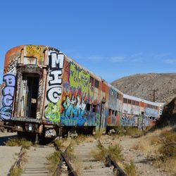
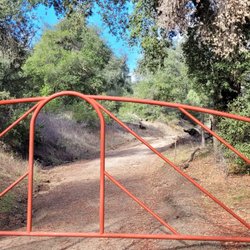
I'm planning to hike to the Goat Canyon Trestle Bridge. The trail head is by DeAnza Springs Resort, correct? For hotel, it would be convenience for me to stay at this resort? I heard the Resort staff even give a map of the Trestle Bridge Hike.
Yes and yes. The office provides detailed maps and verbal directions for any and all trails. The trail head is in the northwestern corner of the resort. Many options for overnight accommodations as well.
Review Highlights - DeAnza Springs Resort
You might also consider


Why does Yelp recommend reviews?
12 reviews that are not currently recommended
The reviews below are not factored into the business's overall star rating.
7 years ago
3 years ago
4 years ago
9 months ago
9 months ago
8 years ago
5 years ago
2 years ago
3 years ago
1 year ago
2 years ago
8 years ago
DeAnza Springs Resort - hiking - Updated May 2026
Best of Jacumba
People found DeAnza Springs Resort by searching for…
Trending Searches in Jacumba, CA
Browse Articles
Browse Nearby
Browse Brands
Related Cost Guides
Related Searches in Jacumba, CA
Affordable Lodging Options in Jacumba, California
Best Fishing Locations and Guides in Jacumba, California
Best Nature Trails for Hiking in Jacumba, California
Best Parks for Parties and Events in Jacumba, California
Best Places for Horseback Riding in Jacumba, California
Best Spots for Star Gazing in Jacumba, California
Best Waterfalls and Swimming Holes in Jacumba, California
Browse Top Hotels in Jacumba, California for Your Stay
Browse the Best Casinos Located in Jacumba, California
Check Out Off Road Trails in Jacumba, California
Discover Baseball Fields Around Jacumba, California
Discover Dog Friendly Beaches Near Jacumba, California
Discover Dog Friendly Trails to Explore in Jacumba, California
Discover Free Campgrounds in Jacumba, California Area
Discover Lakes & Ponds to Explore in Jacumba, California
Discover Popular Photo Spots in Jacumba, California
Discover Scenic Beach Camping Sites in Jacumba, California
Discover Scenic Mountain Bike Trails Near Jacumba, California
Discover Stunning Skyline View Spots in Jacumba, California
Discover Top Nature Parks to Visit in Jacumba, California
Discover a Hiking Trail in Jacumba, California
Discover the Best Fishing Lake in Jacumba, California
Discover the Best Night Hike Trails in Jacumba, California
Dog-Friendly Hikes With Dogs in Jacumba, California
Effective Stairs Workout Spots in Jacumba, California
Enjoy Exciting Mountain Biking Adventures in Jacumba, California
Enjoy Hiking Adventures in Jacumba, California
Enjoy Scenic Night View Experiences in Jacumba, California
Enjoy Tent Camping Spots Around Jacumba, California
Enjoy the Best Picnic Spots and Ideas in Jacumba, California
Enjoy the Best Walking Trails in Jacumba, California
Exciting Cliff Jumping Spots in Jacumba, California
Experience Stunning Sunset Views in Jacumba, California
Explore Beautiful Parks and Green Spaces in Jacumba, California
Explore Easy Hikes Perfect for All in Jacumba, California
Explore Hotels & Travel Options in Jacumba, California
Explore Popular Campgrounds Near Jacumba, California
Explore Popular Picnic Areas Around Jacumba, California
Explore Popular RV Parks Around Jacumba, California
Explore Popular View Points Around Jacumba, California
Explore Scenic Lakes to Visit in Jacumba, California
Explore Secret Spots Worth Visiting in Jacumba, California
Explore Top Dog Parks in Jacumba, California Near You
Explore the Best Swimming Holes Around Jacumba, California
Explore the Best Trail Options in Jacumba, California
Find Beautiful Views in Jacumba, California
Find Cozy Camping Cabins in Jacumba, California
Find Fun Kids Activities Outdoor in Jacumba, California
People who viewed DeAnza Springs Resort also viewed
Lake Morena Rv Park
6 reviews
Jacumba Hot Springs Hotel
111 reviews
The Oaks at Sacred Rocks
37 reviews
Pine Valley Inn Motel
39 reviews
$
Back Country Motel Inn
14 reviews
$$
Sunbeam Lake Rv Resort
12 reviews
Camp Oliver
8 reviews
Goat Canyon Trestle
34 reviews
Ocotillo Trailer Park & Motel
3 reviews
Cottonwood Campground
4 reviews