Cancel

    Open app

    Search

    Cumberland Town Forest

    3.5 (2 reviews)

    Cumberland Town Forest Photos

    You might also consider

    Recommended Reviews - Cumberland Town Forest

    Your trust is our priority, so businesses can't pay to alter or remove their reviews. Learn more about reviews.
    Yelp app icon
    Browse more easily on the app
    Review Feed Illustration

    1 year ago

    Helpful 2
    Thanks 1
    Love this 2
    Oh no 0
    Photo of Steff D.
    4990
    1260
    20031

    6 years ago

    Helpful 12
    Thanks 0
    Love this 8
    Oh no 0

    Verify this business for free

    People searched for Hiking 528 times last month within 15 miles of this business.

    Verify this business

    Bradbury Mountain State Park

    Bradbury Mountain State Park

    4.5(32 reviews)
    8.3 mi

    From my original review: "'You know what I love about this place? It's low risk, high reward.'" We…read moreoverheard an older woman tell her husband this as they approached the summit. And as we stretched out on the rocks enjoying our picnic in the the warm sun, taking in the view of what seemed to be endless forests, bodies of water, and islands, we couldn't have agreed more." A decade later this is still true. If you're looking for an easygoing, very accessible way to go hiking and get some fresh air while wandering Maine's woods, take in the changing leaves of autumn or the abundance of blossoms and wildflowers in the spring, Bradbury - located just thirty minutes from Portland - is hard to beat. According to their website, Bradbury Mountain State Park was one of the original five state parks in the state of Maine, acquired by the Federal government in 1939. The mountain is open year round from 9am until sunset and offers a variety of hiking trails that range from very, very easy ("wide gradual ascents", "well packed and fairly flat") to slightly more challenging ("steepest ascent, but not difficult to hike", "areas with sharp turns"), from .2 miles to 1.5 miles (or more if you want to build your own adventure here - which is very easy to do because this state park's trails are now abundantly well marked; expect lots of maps throughout to let you know where you are AND lots of wooden signs pointing you in the right direction). You could easily do it all in one half day or break up your walk and come back another time, especially considering it's an easy, convenient mountain with an elevation of just 485 feet. Dogs are allowed on leashes, horses are allowed on certain trails. There are bathrooms. You can check out an old cattle pound. Explore for geocaches. It's a cute little mountain, and I'm so happy it's right in (proverbial) our backyard.

    I remember going here as a kid and I took my youngest son almost a decade ago. We wanted to do the…read moresummit trail and climb Bradbury Mountain. Definitely not a big challenge but it was fun. I grew up in Lewiston so this park is close by. I will have to take John next time we're in Maine. Lots of other trails to explore.

    Photos
    Bradbury Mountain State Park
    Bradbury Mountain State Park
    Bradbury Mountain State Park

    See all

    Rines Forest

    Rines Forest

    5.0(1 review)
    1.5 mi

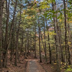
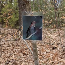
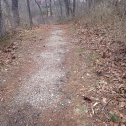
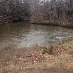
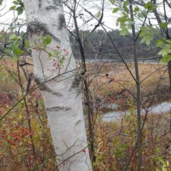
    I feel the need to preface all of my nature reviews with this: being 90% forested and having around…read more3500 miles of coastline, Maine (and NH) has a tremendous amount of spaces, walkways, paths, and trails of all kinds and of all levels. There's something for everyone. What I'm reviewing is how a spot compares to similar outdoor spots in my personal opinion. Being in nature - and remembering to carry in, carry out - is always five stars! :) Parking? Sort of. Loop trail? Yes. Well marked signs? Yes. Element of surprise? Yes. I first discovered Rines Forest a few years ago, and maybe I came at the wrong time (seasonally, emotionally, mentally, whatever) because I thought it was just a long walk in the woods. I don't know why, but I felt compelled to come back this spring and... MAGICAL. Enchanted forest magical, actually. Why? Two words: cascading waterfalls. I believe that from my first visit to now the Chebeague & Cumberland Land Trust has put some serious time, energy, money, and love into this spot because there's an abundance of really well made bridges now. The trail feels much more accessible, groomed, and tremendously well marked. I never felt lost because of the abundance of "You Are Here" laminated maps and tree blazes. Also: there's all this educational material thoughtfully dispersed throughout the trail systems. Laminated information hanging from trees about the local flora and fauna you might see. Definitely kid-friendly! (Speaking of which, there's a Rines Forest Scavenger Hunt available at https://www.ccltmaine.org/rines-forest). Parts of the trail have some slight inclines, are a bit twisty, and rooty in some spots (especially the right hand side of the Loop Trail when you first enter), but it's definitely become one of my favorite spots. Time it so you come right after a rainy spell to see the falls in all their glory!

    Photos
    Rines Forest - Well that's a beautiful bridge!

    Well that's a beautiful bridge!

    Rines Forest - Welcome to Rines Forest!

    Welcome to Rines Forest!

    Rines Forest

    See all

    Knight's Pond Preserve - Knight's Pond and foliage.

    Knight's Pond Preserve

    4.0(1 review)
    2.3 mi

    I'm not entirely sure how I ended up at Knight's Pond Preserve... a free afternoon on a sunny…read moreautumn day tends to inspire me to get outside and play, and before I knew it I was driving down what seemed like a very long driveway (Greely Road Extension) that eventually deposited me at a parking lot. The 300-acre preserve is the largest undeveloped parcel in Cumberland and was "created" in 2015 after conservation efforts led to the acquisition of a major portion of the land. The preserve features a 46-acre pond with an adjacent smaller pond that seems dammed-in (the trail doesn't lead to the stone wall that holds the water, but you can walk over carefully to see) that connects during wetter seasons - there's a wooden bridge to cross into the woods over any water that may be there, a fantastic trail system with great signage through dense woods (there's enough variety here that you could make your hike as short or as long as you like - personally, I like the White trail to the Blue trail, a digression to the FAA tower, to the Red trail, back to the White trail), views of Casco Bay and Mount Washington (on super clear days) from the ridgeline, an FAA radar tower, tons of birds... it's just a very, very nice spot. I came just to walk around and don't feel like I had the opportunity to see everything making me really excited to come back and explore more. Apparently in the winter it's a great spot for pick-up hockey games and ice skating, as well as snowshoeing! I'll be inside drinking bourbon and hiding from the cold then, but if you start to feel like you're getting cabin fever know this is an accessible spot year round!

    Photos
    Knight's Pond Preserve - A beautiful way to end 2018. Peaceful walk in the woods

    A beautiful way to end 2018. Peaceful walk in the woods

    Knight's Pond Preserve - Knight's Pond Preserve.

    Knight's Pond Preserve.

    Knight's Pond Preserve - Love tree.

    See all

    Love tree.

    Littlejohn Island Preserve - The jagged, beautiful rocks of the Maine coast.

    Littlejohn Island Preserve

    4.0(1 review)
    6.3 mi

    There's something alluring when a place boasts of only allowing x-amount of visitors at a time…read more Like - what's so special and magical about this place that they need to keep it so unoccupied? And why are we as people drawn to that sort of exclusivity? I don't know. But it's one of the reasons why we decided to check out the Littlejohn Island Preserve. It was a Sunday afternoon, about an hour from dusk, and we really didn't think we were going to get a spot... but apparently nobody nature walks in December in blustery weather, so we had the place to ourselves. PLEASE NOTE: there really are ONLY four parking spaces with many, MANY signs warning of being towed should you foolishly choose to park anywhere else. The four spaces are about a quarter mile from the actual preserve which is down a private lane. The 23-acre preserve is open during daylight hours only and is about a 1.3 mile loop trail; it's very, very flat and has plenty of manmade wooden plank bridges (and a layer of wood chips where there aren't any) making it pretty accessible to walkers of all ages and ability levels. The ocean views are wonderful, and there are even a few areas where you can walk right down to exposed beach during low tide. However... if you can't get here for whatever reason (like say because there's only four parking spaces), the trails on both Mackworth Island in Falmouth and Wolfe's Neck State Park in Freeport are incredibly similar in both walkability and views (the former also having restricted parking [just not quite as severe]; the latter charging for entry).

    Photos
    Littlejohn Island Preserve - Views from the Littlejohn Island Preserve.

    Views from the Littlejohn Island Preserve.

    Littlejohn Island Preserve - The trail map and information at the entrance of Littlejohn Island Preserve.

    The trail map and information at the entrance of Littlejohn Island Preserve.

    Littlejohn Island Preserve - Views from the Littlejohn Island Preserve.

    See all

    Views from the Littlejohn Island Preserve.

    Donnabeth Lippman Park

    Donnabeth Lippman Park

    5.0(2 reviews)
    10.7 mi

    This is a great little trail to take your kiddos on. There's a playground, a story walk (that…read morechanges monthly), beautiful water views and an easy to follow trail around the pond. If you take a little detour off the story walk, you'll even find a cool teepee shaped bunch of sticks leaning against a tree. Children love to explore this area. It's not so far off the path that you'd ever get lost. In between the first few pages of the story walk, when you have an opportunity to go straight, do so. I promise it's only a few feet down the path. Can't miss it!

    I wasn't expecting so much from this little park right off Route 302 (it's located on a dirt road…read morejust after the Westbrook Pool & Spa; there's a large granite sign at the mouth of the road, and you've probably passed it a million times - I know I have - but once you see it, you'll know exactly where this gem is forever)! Donnabeth Lippman Park - formerly known as Chaffin Pond Preserve - is 123 acre mostly wooded area that surrounds a 10 acre pond that's apparently great for fishing. I came here for a walk in the woods and was delighted to find that there was more than meets the eye: there's a family-friendly (you could easily take a stroller here - it's packed earth and not very root-y), totally accessible to all abilities, story book trail with a giant "Once Upon A Time" sign inviting you into the woods (how magical and fantastical is that?). Once you're finished, you can walk back to the parking lot from here via the yellow trail or you can take that same trail and follow it up alongside the pond, through the woods, then back down around the opposite side of the water (side note: I love loop trails - who wants to double back and see the same things?). A red trail deviates off to Mud Pond, and a green trail just adds an extended path through the forest before reconnecting to yellow. All of it is perfectly marked! It's a wonderful walking trail and if I lived nearby I could see this also being a solid spot for a good run! Admittedly, after heavy rain or during spring you should expect it to be quite muddy. No hunting allowed here, so it's a good spot for year round enjoyment (for those of you who are looking for a new snowshoeing spot!); there's an abundance of picnic tables overlooking the pond, a swing set, a big playground area, and plenty of green space to stretch out on. Again - what an unexpectedly great spot hidden in plain sight!

    Photos
    Donnabeth Lippman Park
    Donnabeth Lippman Park
    Donnabeth Lippman Park

    See all

    Jewell Falls

    Jewell Falls

    4.2(13 reviews)
    9.0 miNasons Corner

    This hike is a nice place to take a short stroll for the locals but not a place I would recommend…read moretourist to come. First off, it is only about half mile from parking to the waterfall. So total hike was only 1 mile. it is a WALK, not hike. Good for families with young ones. Be very aware that the mosquitoes here are super HUNGRY! I have never gotten so many bites within such a short time inside a hike! I got 6-7 bites all over my legs just from hiking here for 30 mins. My husband got 8+ bites all over his body! Luckily my little one only got 1 bite. We were all over Maine in the last 2 weeks including kayaking and out at Acadia national park. All outdoor activities and barely got any bites until now! There are other trails here too but after getting so many bites, we wanted to run away as fast as we could! I wish I didn't come here. View and waterfall are not worth it for trade off of these hungry hungry mosquitoes!! *sooo itchy* :-/ Bring bug spray if you wanna come!

    Jewell falls is a waterfall of water flowing from the Fore River and is named for Tom Jewell who…read morewas one of the founders Portland Trails and very much alive today. Did you know that Portland Trails started in 1991? He donated the land around the falls and the rest of the land the trail walls through is a mix of public and private land. You see evidence of this with many marked signs that designate private property -- good to respect these so we can continue to walk these trails. Somehow I got lost off my usual path I take and ended up going on the greater fore river sanctuary trail loop around and across the railroad tracks, but the boardwalks were great! Back to the falls, if you start at the trailhead near Brighton ave, it's less than 0.25 miles of a walk. The falls are made of horsetails of rushing water over large slabs of rock. The trails are really well maintained and there's not too many people. You can definitely still hear traffic from some parts but there are a few quiet enclaves.

    Photos
    Jewell Falls
    Jewell Falls
    Jewell Falls - My friend on the tracks at the entrance!

    See all

    My friend on the tracks at the entrance!

    Spear Farm Estuary Preserve

    Spear Farm Estuary Preserve

    5.0(1 review)
    4.4 mi

    My first time exploring the Spear Farm Estuary Preserve was immediately after The Great Maine Wind…read moreStorm - and the damage it caused to the trails and trees was both devastating and breathtaking at the same time. To be walking alone through such a scene of natural wreckage on a beautiful sunny day in the fall felt haunting and peaceful - was this scene from some apocalypse film? Admittedly, I probably shouldn't have been walking through here when so much of the walking path was obstructed by downed enormous trees, but it was like an adventure crawling under and climbing over them! Despite the unique circumstances of my first visit, this is a spot that I would absolutely come back to again and again (I bet it's amazingly serene in December before the first snowfall!). There's off street parking, and the preserve itself is a 55+ acre area with a big freshwater pond and benches overlooking it, woodlands and a high-canopy forest, and open salt marshes as it abuts the Royal River. With over a mile and a half of accessible, extremely well manicured, well marked trails that loop and plenty of places to sit and enjoy a picnic, it's one of those hiking spots that I'm genuinely glad to know about (it was fun meandering around here without fear of getting lost since all the trails connect and the ocean acts as a natural border. You know you've found a good trail when you feel sad after you've "reached the end" of your first walkthrough of it! Before you go: hunting is allowed - though it has to be 300+ feet away from the trails - so be sure to rock your orange in October and November; beware of ticks; and, don't stomp around off trails too much (that way we can actually preserve this amazing, diverse habitat).

    Photos
    Spear Farm Estuary Preserve - Spear Farm Estuary Preserve from autumn of '17.

    Spear Farm Estuary Preserve from autumn of '17.

    Spear Farm Estuary Preserve - Spear Farm Estuary Preserve from autumn of '17.

    Spear Farm Estuary Preserve from autumn of '17.

    Spear Farm Estuary Preserve - Spear Farm Estuary Preserve from autumn of '17.

    See all

    Spear Farm Estuary Preserve from autumn of '17.

    Cumberland Town Forest - hiking - Updated May 2026

    Loading...
    Loading...
    Loading...