Crowley Lake Columns Photos


More like Crowley Lake Columns
Recommended Reviews - Crowley Lake Columns
Start your review...

Reviews With Photos

Like you're transcended into a different millennium when you visit here. Short hike down but the drive to get here requires you to have a 4wheel drive. It's a must or you can get stuck calling AAA to tow you out. Which we did t expect without a warning. So be prepared and not be sorry. Beautiful view from above when you see the Mountain View and the lake and then the columns. Made of salt and magnesium it seems what creates these columns depending on the winds and water temperature over time. Definitely a one of a kind view that you can find here in mammoth lakes other picturesque beauty. A must visit!

This review is for Crowley Lake Columns which was a ~4.2 miles round trip that took ~2 hour to complete. Just a short 25 minutes drive from Convict Lake. Unique rock formations at the end! Last stretch to the columns was steep and sandy. Park on the side of the dirt road, shortly past the dam (Use AllTrails Direction for accurate location). Or if you have a 4WD, you can drive all the way to the hill just above the beach and hike down to the columns. Short video of the hike for those interested! https://youtu.be/mxdOfJi5Vgk

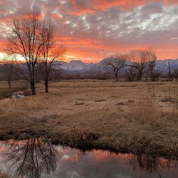
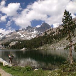
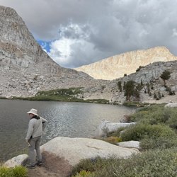
This is a local natural feature that is viewable when the lake level has dropped at the end of the summer season. Crowley Lake is a great place to stop fish and hike or kayak when visiting the Eastern Sierra. There's great beauty here. At 7000 ft elevation, if you're cped at the beach here, you can have a wonderful view of the clear night sky. There's actually an awesome 360 degree view of high Sierran mountain peak ranges to enjoy and photograph and return home with the memory of a most remarkable place.

This lake is awesome. We rented a pontoon boat & cruised all over the lake. The only thing you have to watch out for is the shallows. The underwater plants can make your boat stuck but we didn't have that trouble. This lake is full of wildlife & nature. Many different birds, cattle, & views to look at. Very enjoyable. Great spot to bring your lunch & drinks.

Crowley Lake is not easy to get to, it's about 30 minutes drive off 395 fwy, and 15 mins drive on the dirt road with a 4WD car before you get to the lake. However, the bumpy drive in is totally worth it! Crowley Lake The moment we arrived at the lake, we are totally mesmerized by the view! The reflection on the lake is breathtaking! Crowley Lake Columns To get to the Crowley Lake Columns, there are no obvious trails or signs to lead you the way to the columns. The only way to get to the beach to the columns is to hike down towards the right. It's a short but slightly steep hike so do bring some water with you. Climbing down is easier, climbing up takes up more energy. Hope you have fun like we do at Crowley Lake! It's one of our favorite lake we have been! It's a beautiful lake!

The columns are one of a kind and absolutely amazing. My only complaint is that there are too many mosquito flying around, probably it's due to summer and close to a lake. Otherwise I would spend more time there. In regards to direction and transportation, I drove there with a civic and I promise I won't do it again. High clearance 4x4 suv is highly recommended. I used google to navigate and was able to reach to the end. Then just hike down to the beach (the trial is a little steep but doable) Recommend hiking poles. https://goo.gl/maps/5SDxNGaMkHP2

Explore breathtaking, one-of-a-kind columns and caves at Crowley Lake, only 30 minutes from Mammoth. Low lake levels from the on-going drought in California have exposed the columns and caves making them accessible for exploration. They really are way too cool not to check out if you can! **I can't imagine accessing them without a 4wd vehicle or a boat/kayak. Directions by car - From Bishop you head North for about 30-40 miles until you hit Benton Crossing Rd. and make a right. From here, continue West and bending South for close to 20 miles. You will pass many turn offs, but you are looking for a dirt road that will be 2 miles after the Layton Springs Rd. turn off. The dirt road IS NOT labeled at the pavement. If you hit Owens Gorge Rd., you have gone too far. You will then be able to follow the dirt roads and ignore the couple of turn offs, the tire tracks will be obvious. (Satellite view on Google Maps shows these dirts roads and you can follow along on there if needed). About 10 minutes of driving on the dirt road and it will spit you out on the beach of Crowley Lake. You will start to see the columns or chalk towers along the cliffs of the lake which continue along the beach for a couple miles. The road is mostly fairly easy to navigate but the road to the columns is a dirt road with rocks and dips and it is quite narrow in areas. We went in December/January and while it was brisk, the sun was quite warm when it was out and the snow capped mountains made the sites even more magical. Plus, we were there an entire day and only saw one other group of people! Be sure to bring plenty of water, snacks/food...there is nothing for miles and be aware that the wind can be kicking here so bring appropriated clothing. Don't forget your camera!

1 year ago
Must added to the list for hiking / beach/ kayak spot. No need a big jeep or any special vehicle. You will be fine as it's easy to get down to these stone pillars with 2 mi hike. Very easy flat step - straight road. Actually there's one big deep hold up hill at the beginning and one slightly slippery downhill to the lake. General, worth the hike and time to visit the unique nature made sandstone pillars. A beautiful place with peaceful quiet lake. You can hang around right at the lake or do kayak Tips: - When you are inside - under these columns, never look up. There is always some sand falling from top. - No restroom / trash bin / info center. Make sure bring water and essential items. - Plan to arrive early so you can come back around before noon. And use a lot of sunscreen in summer. No shade at all. Like walk in the middle of dessert! - Parking spots are marked correctly in google map. No actually parking signs. You just find your own the spot closest to the first hill and leave the car there at your own risk for 1hr at least. - follow google map. There's some crosspath and no signage! read more


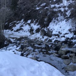
From the 395, there's a nice dirt road to Crowley Lake but you can only go so far with a regular car. A 4x4 off road vehicle is needed to access the stone columns for the last mile or two. There's a hill with really bad ruts. Another way to access the columns is to kayak to them. We saw a kayaker who parked his car at another beach off the lake and kayaked over. There is a steep sandy trail down to the beach where the columns are. The water was high when we were there so fortunately we couldn't access the larger columns that day. It's definitely worth the visit when the water level in the lake is low to see these unique stone columns. read more


1 year ago
Crowley lake is a beautiful lake with clean,clear water and big trout of every kind, rainbow trout and brown trout is what we caught . Our family had an amazing time and made beautiful memories we will cherish forever. read more


Like you're transcended into a different millennium when you visit here. Short hike down but the drive to get here requires you to have a 4wheel drive. It's a must or you can get stuck calling AAA to tow you out. Which we did t expect without a warning. So be prepared and not be sorry. Beautiful view from above when you see the Mountain View and the lake and then the columns. Made of salt and magnesium it seems what creates these columns depending on the winds and water temperature over time. Definitely a one of a kind view that you can find here in mammoth lakes other picturesque beauty. A must visit! read more


This review is for Crowley Lake Columns which was a ~4.2 miles round trip that took ~2 hour to complete. Just a short 25 minutes drive from Convict Lake. Unique rock formations at the end! Last stretch to the columns was steep and sandy. Park on the side of the dirt road, shortly past the dam (Use AllTrails Direction for accurate location). Or if you have a 4WD, you can drive all the way to the hill just above the beach and hike down to the columns. Short video of the hike for those interested! https://youtu.be/mxdOfJi5Vgk read more


1 year ago
4 years ago
This is a local natural feature that is viewable when the lake level has dropped at the end of the summer season. Crowley Lake is a great place to stop fish and hike or kayak when visiting the Eastern Sierra. There's great beauty here. At 7000 ft elevation, if you're cped at the beach here, you can have a wonderful view of the clear night sky. There's actually an awesome 360 degree view of high Sierran mountain peak ranges to enjoy and photograph and return home with the memory of a most remarkable place. read more


This lake is awesome. We rented a pontoon boat & cruised all over the lake. The only thing you have to watch out for is the shallows. The underwater plants can make your boat stuck but we didn't have that trouble. This lake is full of wildlife & nature. Many different birds, cattle, & views to look at. Very enjoyable. Great spot to bring your lunch & drinks. read more


4 years ago
Crowley Lake is not easy to get to, it's about 30 minutes drive off 395 fwy, and 15 mins drive on the dirt road with a 4WD car before you get to the lake. However, the bumpy drive in is totally worth it! Crowley Lake The moment we arrived at the lake, we are totally mesmerized by the view! The reflection on the lake is breathtaking! Crowley Lake Columns To get to the Crowley Lake Columns, there are no obvious trails or signs to lead you the way to the columns. The only way to get to the beach to the columns is to hike down towards the right. It's a short but slightly steep hike so do bring some water with you. Climbing down is easier, climbing up takes up more energy. Hope you have fun like we do at Crowley Lake! It's one of our favorite lake we have been! It's a beautiful lake! read more


4 years ago
10 years ago
The columns are one of a kind and absolutely amazing. My only complaint is that there are too many mosquito flying around, probably it's due to summer and close to a lake. Otherwise I would spend more time there. In regards to direction and transportation, I drove there with a civic and I promise I won't do it again. High clearance 4x4 suv is highly recommended. I used google to navigate and was able to reach to the end. Then just hike down to the beach (the trial is a little steep but doable) Recommend hiking poles. https://goo.gl/maps/5SDxNGaMkHP2 read more


10 years ago
Explore breathtaking, one-of-a-kind columns and caves at Crowley Lake, only 30 minutes from Mammoth. Low lake levels from the on-going drought in California have exposed the columns and caves making them accessible for exploration. They really are way too cool not to check out if you can! **I can't imagine accessing them without a 4wd vehicle or a boat/kayak. Directions by car - From Bishop you head North for about 30-40 miles until you hit Benton Crossing Rd. and make a right. From here, continue West and bending South for close to 20 miles. You will pass many turn offs, but you are looking for a dirt road that will be 2 miles after the Layton Springs Rd. turn off. The dirt road IS NOT labeled at the pavement. If you hit Owens Gorge Rd., you have gone too far. You will then be able to follow the dirt roads and ignore the couple of turn offs, the tire tracks will be obvious. (Satellite view on Google Maps shows these dirts roads and you can follow along on there if needed). About 10 minutes of driving on the dirt road and it will spit you out on the beach of Crowley Lake. You will start to see the columns or chalk towers along the cliffs of the lake which continue along the beach for a couple miles. The road is mostly fairly easy to navigate but the road to the columns is a dirt road with rocks and dips and it is quite narrow in areas. We went in December/January and while it was brisk, the sun was quite warm when it was out and the snow capped mountains made the sites even more magical. Plus, we were there an entire day and only saw one other group of people! Be sure to bring plenty of water, snacks/food...there is nothing for miles and be aware that the wind can be kicking here so bring appropriated clothing. Don't forget your camera! read more


6 years ago
Looking to explore a unique natural wonder in Mono County? Check out The Columns! This area is not easily accessible tho. You will need a vehicle with 4x4 and bring a device with satellite map to assist with locating the area. Google maps took us the wrong way when we adventured in and we had to climb a very steep grade with deep ruts. It was challenging but we got thru using 4x4 4LO in our MegaCab. Once you find the area you can either drive down to the beach and walk to the Columns if the water level is low or you will need to park at the top of the hill and hike down to the Columns. When we went the water level was high so we had to hike down. There is no defined trail but you can't get lost. You can also access the area if you had a water craft which we didn't have. Lots to see. Just be careful so as not to damage the Columns so others can enjoy. There are no interpretive plaques so research the history before you go. The trail we took out was narrow and I got some new pin stripes to prove it but this adventure was definitely worth it. read more


9 years ago
8 years ago
9 years ago
More info about Crowley Lake Columns
Ask the Community - Crowley Lake Columns
Review Highlights - Crowley Lake Columns


Crowley Lake Columns - landmarks - Updated June 2026
Best of Bishop
People found Crowley Lake Columns by searching for…
Things to Do in Bishop, California
Sunset View in Bishop, California
Things to Do at Night in Bishop, California
Photo Spots in Bishop, California
Off Road Trails in Bishop, California
Cave Tour in Bishop, California
Scenic Drive in Bishop, California
Scenic View in Bishop, California
Natural Hot Springs in Bishop, California
Stargazing in Bishop, California
Waterfall in Bishop, California
Attractions in Bishop, California
Hiking Trails in Bishop, California
Watch Sunset in Bishop, California
Night View in Bishop, California
Places to Visit in Bishop, California
Trending Searches in Bishop, CA
Boat Rental near Crowley Lake Columns
Caves near Crowley Lake Columns
Cliff Jumping near Crowley Lake Columns
Fireworks near Crowley Lake Columns
Fishing Spots near Crowley Lake Columns
Kayak Rental near Crowley Lake Columns
Landmarks & Historical Buildings near Crowley Lake Columns
Picnic Areas near Crowley Lake Columns
Public Pools near Crowley Lake Columns
River Swimming near Crowley Lake Columns
River Tubing near Crowley Lake Columns
Scenic Restaurants near Crowley Lake Columns
Sightseeing near Crowley Lake Columns
Swimming Holes near Crowley Lake Columns
Browse Articles
Browse Nearby
BEST of Bishop, California Coffee near Crowley Lake Columns
BEST of Bishop, California Restaurants near Crowley Lake Columns
BEST of Bishop, California Breakfast near Crowley Lake Columns
BEST of Bishop, California Hotels near Crowley Lake Columns
BEST of Bishop, California Campgrounds near Crowley Lake Columns
Browse Brands
Related Searches in Bishop, CA
Best Fishing Locations and Guides in Bishop, California
Best Fun Things to Do in Bishop, California
Best Lookout Points to Visit in Bishop, California
Best Spots for Star Gazing in Bishop, California
Book Engaging Historical Tours in Bishop, California
Discover Fun Kid Activities to Enjoy in Bishop, California
Discover Popular Photo Spots in Bishop, California
Discover Top Nature Parks to Visit in Bishop, California
Discover the Best Beaches in Bishop, California
Discover the Best Caves to Explore in Bishop, California
Enjoy Arts & Entertainment in Bishop, California
Enjoy Hiking Adventures in Bishop, California
Enjoy Scenic Night View Experiences in Bishop, California
Enjoy the Best Walking Trails in Bishop, California
Experience Stunning Sunset Views in Bishop, California
Explore Beautiful Castles and Landmarks in Bishop, California
Explore Beautiful Parks and Green Spaces in Bishop, California
Explore Free Things to Do Around Bishop, California
Explore Fun Activities to Do in Bishop, California
Explore Popular Scenic Views Near Bishop, California
Explore Scenic Lakes to Visit in Bishop, California
Explore Top Art Galleries Located in Bishop, California
Explore Venues & Event Spaces in Bishop, California
Find Beautiful Views in Bishop, California
Find Exciting Tours to Take in Bishop, California
Find Fun Things to Do With Kids in Bishop, California
Find Top Libraries to Visit in Bishop, California
Find the Best Bridge Spots in Bishop, California
Find the Best Playgrounds to Visit in Bishop, California
Fun Things for Kids in Bishop, California
Hiking Trails With Waterfalls in Bishop, California
Must-See Tourist Attractions Around Bishop, California
Perfect Spots to Watch Sunset in Bishop, California
Popular Kids Activities in Bishop, California
Popular Picnic Spots to Visit in Bishop, California
Popular Places to Take Pictures in Bishop, California
Popular Places to Walk Around in Bishop, California
Popular Things to Do in Bishop, California
Popular Things to See in Bishop, California
Relax at Natural Hot Springs Near Bishop, California
Secure Convenient Parking Options in Bishop, California
Stair Climbing Activities and Gyms in Bishop, California
Top Entertainment Options in Bishop, California
Top Hiking Trails to Explore in Bishop, California
Top Historic Restaurants to Try in Bishop, California
Top Things to Do With Kids in Bishop, California
Tour Famous Lighthouses Located in Bishop, California
Visit Popular Museums in Bishop, California Now
People who viewed Crowley Lake Columns also viewed
Devil's Postpile National Monument
129 reviews
Minaret Vista
16 reviews
Mammoth Mountain Scenic Gondola
45 reviews
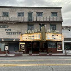
Laws Railroad Museum & Historical Site
72 reviews
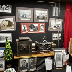
The Bishop Area Chamber of Commerce
46 reviews
Mammoth Lakes Library
15 reviews
Bishop Library
4 reviews
US Post Office
10 reviews
The UPS Store
6 reviews
Highway Patrol
3 reviews