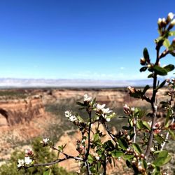
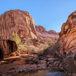
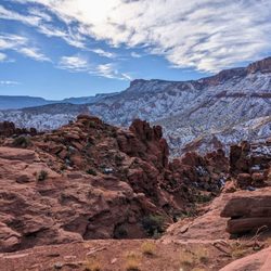
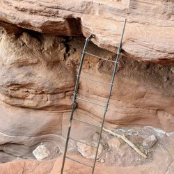
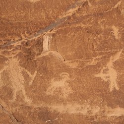
Colorado National Monument - Devil's Kitchen Trail Photos


More like Colorado National Monument - Devil's Kitchen Trail
Recommended Reviews - Colorado National Monument - Devil's Kitchen Trail


More info about Colorado National Monument - Devil's Kitchen Trail


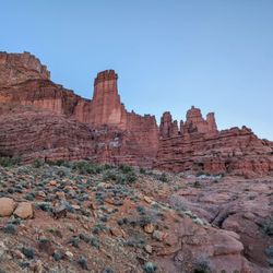


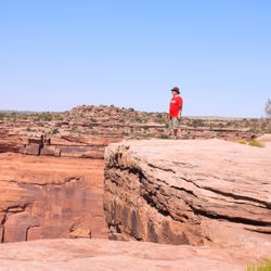


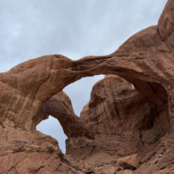


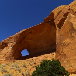


Colorado National Monument - Devil's Kitchen Trail - hiking - Updated May 2026
Best of Fruita
People found Colorado National Monument - Devil's Kitchen Trail by searching for…
Things to Do With Kids in Fruita, Colorado
Playgrounds in Fruita, Colorado
Places to Take Pictures in Fruita, Colorado
Cliff Jumping in Fruita, Colorado
Picnic Areas in Fruita, Colorado
Fun Things to Do at Night in Fruita, Colorado
Public Showers in Fruita, Colorado
Hiking Trails in Fruita, Colorado
River Swimming in Fruita, Colorado
Places to Swim in Fruita, Colorado
Beautiful Views in Fruita, Colorado
Sunset View in Fruita, Colorado
Star Gazing in Fruita, Colorado
Watch Sunset in Fruita, Colorado
Secret Spots in Fruita, Colorado
Canyoneering in Fruita, Colorado
Parks for Kids in Fruita, Colorado
Things to Do With Teenagers in Fruita, Colorado
Scenic Overlook in Fruita, Colorado
Photo Spots in Fruita, Colorado
Trending Searches in Fruita, CO
Boat Rental near Colorado National Monument - Devil's Kitchen Trail
Bounce House Rentals near Colorado National Monument - Devil's Kitchen Trail
Campgrounds near Colorado National Monument - Devil's Kitchen Trail
Cliff Jumping near Colorado National Monument - Devil's Kitchen Trail
Floral Designers near Colorado National Monument - Devil's Kitchen Trail
Flower Shop near Colorado National Monument - Devil's Kitchen Trail
Garden Center near Colorado National Monument - Devil's Kitchen Trail
Garden Statues near Colorado National Monument - Devil's Kitchen Trail
Lakes near Colorado National Monument - Devil's Kitchen Trail
Nurseries & Gardening near Colorado National Monument - Devil's Kitchen Trail
Outdoor Furniture Stores near Colorado National Monument - Devil's Kitchen Trail
Parks near Colorado National Monument - Devil's Kitchen Trail
Party Equipment Rentals near Colorado National Monument - Devil's Kitchen Trail
Pedicure near Colorado National Monument - Devil's Kitchen Trail
Photo Spots near Colorado National Monument - Devil's Kitchen Trail
Picnic Areas near Colorado National Monument - Devil's Kitchen Trail
Places To Take Pictures near Colorado National Monument - Devil's Kitchen Trail
Playgrounds near Colorado National Monument - Devil's Kitchen Trail
Pool Supplies near Colorado National Monument - Devil's Kitchen Trail
Public Shower near Colorado National Monument - Devil's Kitchen Trail
Running Trails near Colorado National Monument - Devil's Kitchen Trail
Rv Rental near Colorado National Monument - Devil's Kitchen Trail
Sunrise View near Colorado National Monument - Devil's Kitchen Trail
Table And Chair Rentals near Colorado National Monument - Devil's Kitchen Trail
Watch Sunset near Colorado National Monument - Devil's Kitchen Trail
Water Fountains near Colorado National Monument - Devil's Kitchen Trail
Yard Sales near Colorado National Monument - Devil's Kitchen Trail
Browse Articles
Browse Nearby
Browse Brands
Related Searches in Fruita, CO
Best Fishing Locations and Guides in Fruita, Colorado
Best Fun Things to Do in Fruita, Colorado
Best Off Leash Dog Parks in Fruita, Colorado
Best Places for Horseback Riding in Fruita, Colorado
Best Spots for Star Gazing in Fruita, Colorado
Check Out Great Playgrounds in Fruita, Colorado
Discover Beautiful Garden Spots in Fruita, Colorado
Discover Dog Friendly Trails to Explore in Fruita, Colorado
Discover Fun Activities to Do in Fruita, Colorado
Discover Popular Photo Spots in Fruita, Colorado
Discover Top Boat Tours in Fruita, Colorado for All Ages
Discover Top Nature Parks to Visit in Fruita, Colorado
Discover a Hiking Trail in Fruita, Colorado
Discover the Best Beaches in Fruita, Colorado
Discover the Best Night Hike Trails in Fruita, Colorado
Dog-Friendly Hikes With Dogs in Fruita, Colorado
Enjoy Camping Adventures Around Fruita, Colorado
Enjoy Tent Camping Spots Around Fruita, Colorado
Enjoy Water Activities and Fun in Fruita, Colorado
Enjoy the Best Family Activities in Fruita, Colorado
Enjoy the Best Picnic Spots and Ideas in Fruita, Colorado
Enjoy the Best Tubing Experiences in Fruita, Colorado
Exciting Cliff Jumping Spots in Fruita, Colorado
Explore Beautiful Parks and Green Spaces in Fruita, Colorado
Explore Bike Rentals Throughout Fruita, Colorado
Explore Easy Hikes Perfect for All in Fruita, Colorado
Explore Free Picnic Areas Around Fruita, Colorado
Explore Free Things to Do Around Fruita, Colorado
Explore Fun Activities to Do in Fruita, Colorado
Explore Landmarks & Historical Buildings in Fruita, Colorado
Explore Popular Campgrounds Near Fruita, Colorado
Explore Popular Picnic Areas Around Fruita, Colorado
Explore Popular RV Parks Around Fruita, Colorado
Explore Popular Recreation Centers Around Fruita, Colorado
Explore Popular Scenic Views Near Fruita, Colorado
Explore Popular View Points Around Fruita, Colorado
Explore Scenic Lakes to Visit in Fruita, Colorado
Explore Summer Camps for All Ages in Fruita, Colorado
Explore Top Dog Parks in Fruita, Colorado Near You
Explore Top Gyms in Fruita, Colorado Now
Explore Top Water Parks in Fruita, Colorado Today
Explore the Best Boating Spots in Fruita, Colorado
Explore the Best Trail Options in Fruita, Colorado
Find Beautiful Views in Fruita, Colorado
Find Cozy Camping Cabins in Fruita, Colorado
Find Fun Things to Do With Kids in Fruita, Colorado
Find Parks and Recreation Activities in Fruita, Colorado
Find the Best Parks for Picnics in Fruita, Colorado
People who viewed Colorado National Monument - Devil's Kitchen Trail also viewed
Walter Walker State Wildlife
1 review
Sherwood Park
2 reviews
Grand Junction Interactive Water Fountain
2 reviews
Highline Lake State Park
11 reviews
Lincoln Park
2 reviews
Paddleboard Adventure Company
3 reviews
Fruita Community Center
2 reviews
City of Fruita Public Pool
3 reviews
Lincoln Park-Moyer Pool
2 reviews
Colorado Backcountry Biker
33 reviews
$$