Chief Ladiga Trail Photos


More like Chief Ladiga Trail
Recommended Reviews - Chief Ladiga Trail
Start your review...

Reviews With Photos

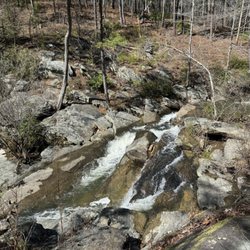
To my surprise this trail had not yet been added to Yelp when I wanted to begin this review. HISTORY The Chief Ladiga Trail is named after a famed Indian Chief who relinquished his tribe's lands when he signed the Treaty of Cusseta in 1832. Half of his land (which would later become Jacksonville) sold for $2000. Kinda makes you wish you had two grand and a time machine huh? The Trail is approximately 33 miles long and stretches from the border of Alabama/Georgia to just north of Anniston, AL. It uses the same rail-to-trail corridor as the Silver Comet in Georgia creating 94.5 miles of non-motorized paved trail... currently the longest in the United States. THE EXPERIENCE This trail traverses beautiful landscapes, including the mountainous Pinhoti National Forest and through the farmlands of Northeast Alabama. We found the trail to be very flat with barely any noticeable inclines or declines. The Silver Comet, on the other hand, has some very extreme inclines especially east of Cedartown. However, unlike the Silver Comet trail, many areas of Chief Ladiga trail are in full sunlight. This is something you might want to keep in mind when traveling in the heat of summer. We had the luxury of my wonderful wife agreeing to meet us at certain points along the trail for encouragement and refreshments. She also drove my truck which allowed us to just pack up at the end of the trail and drive home. Solo bikers would have to travel the same distance back to wherever they started. If I'm being honest, this trail kicked my shizzle, forizzle. I was tired when I started and completely exhausted by the 15 mile marker. I felt pain in my legs the likes of which I'd never felt before... they were on fire. If it were not for the courage of my son, I would have thrown in the towel. We'd completed 76.5 miles of biking at this point, which probably equals all the miles that I've biked in the last 25 years COMBINED. Funny thing is... the Chief Ladiga trail was so much easier than the Silver Comet, but I had simply run out of gas. I struggled the next 9 miles to reach my wife waiting at Germania Springs Park (mile 24). Once we arrived, we loaded the bikes onto my truck and found food. I could barely walk and my legs were so uncomfortably sore that it was difficult to sit down. All the pain came RUSHING in once my body was no longer actively pedaling. I seriously thought there was no way I could finish, but with a little rest and nourishment I found just enough strength to continue the remaining 9 miles from Germania Springs Park to the end of the trail. The details of our journey are as follows: --------------- CHIEF LADIGA TRAIL LOGBOOK (Wednesday - April 10th, 2013) 7:50am - Started Silver Comet Trail in Smyrna, Georgia (mile marker 0.00) 2:48pm - Completed Silver Comet Trail 3:18pm - Start Chief Ladiga Trail (after 30 minute rest) 5:12pm - Mile Marker 20 5:33pm - Mile Marker 24/Germania Springs Park Loaded the bikes and headed to Burger King a few miles up the road. Thought I was done, my body just couldn't take any more. Revived from our meal and a little rest we decided to finish out the last 9 miles. 6:25pm - Restarted from Germania Springs Park 7:14pm - Finished Chief Ladiga trail (3 hours & 56 minutes including 1.25 hour rest) NOTES This trail is more narrow that the Silver Comet, but freshly paved nearly the entire 33 miles. It also has lots of informative plaques, beautiful river crossings and absolutely gorgeous countryside views. The PLUS side - it's very flat with little elevation change the enter trail. The NEGATIVE side - it's very straight and you can see for miles. It makes the end of the trail seem impossible to reach after pedaling for hours. Get's busy around Jacksonville. STATS Time to complete the entire Silver Comet/Chief Ladiga trail - 9 hours : 11 minutes Time with stops - 11 hours : 36 minutes Days to complete the entire trail - 1 Miles traveled - 94.5 Average speed when on the trail - 10.32 miles per hour --------------- THE VERDICT Outstanding trail! If you are starting in Georgia on the Silver Comet, I highly recommend completing this portion of the trail if for no other reason because of it's beautiful views. It will test your endurance, but I should note that I lost 6.5 pounds on the trail today. Completely erased all my gluttony from overeating while visiting Chicago the weekend prior. Yelp100[71]

1 month ago
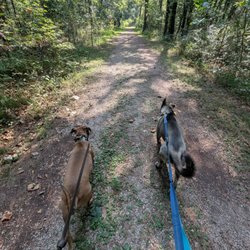
Quiet and peaceful. A little narrow at times, but highly recommend cycling this trail. Clean up after storms is a bit slow (trees down, etc) read more

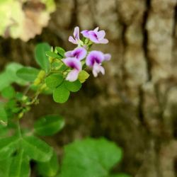
How does this only have 2 reviews? Madness! It's a 33 mile, paved, super clean, well maintained bike trail that goes from a park in Anniston, through the JSU campus and on to the Alabama/Georgia State line. At that point it connects/turns into the Silver Comet Trail which continues another 60 or so miles into Georgia, (for all you psychos who want to bike 90 miles). Most importantly, it is as flat as can be so anyone can ride forever on it without getting into any serious uphill slopes which while for some may be fun, for others may be grueling. There is nothing grueling about this trail. A kid could do it no problem. It is long, and so if you don't want to do the entire thing you can start at the Eubanks Welcome Center in Piedmont and from there it's about 14 miles to the state line. The reason I say to do this section if you're not going to do the entire trail is that this is where the trail starts to go through a forest and so the scenery is nice, it's shaded in most areas and you won't run into many crossings where you'll see any traffic at all. Just a flat, peaceful, meandering section of trail that crosses over streams and goes past pastures and mountains along the way. The welcome center has clean restrooms, plenty of parking and is in a nice safe area. If you have a bike and you're looking for a nice place to ride I'm not sure it gets much better than this. Pack what you need for the Piedmont to State Line section as you won't encounter much along the way as far as places to stop for any supplies. But that's the point right? You're going into a forest. There isn't supposed to be anything out there besides the birds and butterflies and creeks and streams and trees and all that so definitely bring whatever you might need with you. read more


5 years ago
We purchased a Weehoo (a bicycle attachment that allows the toddler to assist in propulsion) a few weeks ago and have been wanting to take it out on the Silver Comet or Chief Ladiga for a while. We decided to take it to Chief Ladiga first even though it's an hour outside or Atlanta because the elevation profile is fairly level for most of the 32 mile section. We also planned to break up the trip with an over night in Jacksonville, AL. You pass through Piedmont, Jacksonville, Weaver and into Anniston where the trail ends. We divided the trip over two days with the out section on a Saturday and return on a Sunday, which made it possible with our 4 year old in the back. I used my 1984 Italian Columbus SLX steel bike to pull the extra 70 lbs which wasn't easy but still managed to average 13 mph and many times was in the 18-19mph sections. If you are single this is totally doable in a day if you start out earlier in the AM. If you are a family however it's best to stretch it out. This past weekend we parked our car at the Esom Hill trail head, assembled our bikes, and got underway towards Alabama. The GA/AL boarder is just a 1/4 mile from the Esom Hill trail head parking lot. About 8 miles into our ride Nicole's tire punctured and we had a short break to fix the flat. The trail was gorgeous as the first 10 miles heads through the Dugger Mountain Wilderness, part of Talladega National Forest. If you pack a tent and gear you could even camp right off the trail within the parks campgrounds. As the trail is mostly down hill towards Piedmont, the next town, we easily covered the first 14 miles within the hour. The trail covers multiple small bridge crossings In the small town of Piedmont other bikers were stopped at the old Station House. One of the intersections is S Center Street where we stopped at Elevated Coffee where besides home baked goods, coffee and breakfast they also stock a few items for cyclists: from inner tubes, CO2 cartridges, and Hammer Nutrition electrolytes. The following 10 - 12 miles were remote again with good tree cover for shade but also patches of sunlight coming through on uncovered sections. Before entering Jacksonville we stopped at Germania Springs Garden, which had a playground for our little one to get out and stretch her legs and was located right off the trail. Jacksonville was approximately 28 miles, short 4-5 miles from the end of the trail, and was also where we spent the night, at the Hilton Garden Inn. From the Hilton Garden in we had dinner at Calhouns Steakhouse after showering and it was a nice 1/2 mile walk from the Hotel. The next morning, I was up early to ride my bike all the way to the end and back, which took just 20 minutes in each direction. Without having a little kid to pull, I was making much better time and I covered about 12 miles, before hitching the family back for the tour back home. This was an epic little weekend getaway, and I'd highly encourage it for anyone who needs it. read more


2 years ago
3 years ago
13 years ago
To my surprise this trail had not yet been added to Yelp when I wanted to begin this review. HISTORY The Chief Ladiga Trail is named after a famed Indian Chief who relinquished his tribe's lands when he signed the Treaty of Cusseta in 1832. Half of his land (which would later become Jacksonville) sold for $2000. Kinda makes you wish you had two grand and a time machine huh? The Trail is approximately 33 miles long and stretches from the border of Alabama/Georgia to just north of Anniston, AL. It uses the same rail-to-trail corridor as the Silver Comet in Georgia creating 94.5 miles of non-motorized paved trail... currently the longest in the United States. THE EXPERIENCE This trail traverses beautiful landscapes, including the mountainous Pinhoti National Forest and through the farmlands of Northeast Alabama. We found the trail to be very flat with barely any noticeable inclines or declines. The Silver Comet, on the other hand, has some very extreme inclines especially east of Cedartown. However, unlike the Silver Comet trail, many areas of Chief Ladiga trail are in full sunlight. This is something you might want to keep in mind when traveling in the heat of summer. We had the luxury of my wonderful wife agreeing to meet us at certain points along the trail for encouragement and refreshments. She also drove my truck which allowed us to just pack up at the end of the trail and drive home. Solo bikers would have to travel the same distance back to wherever they started. If I'm being honest, this trail kicked my shizzle, forizzle. I was tired when I started and completely exhausted by the 15 mile marker. I felt pain in my legs the likes of which I'd never felt before... they were on fire. If it were not for the courage of my son, I would have thrown in the towel. We'd completed 76.5 miles of biking at this point, which probably equals all the miles that I've biked in the last 25 years COMBINED. Funny thing is... the Chief Ladiga trail was so much easier than the Silver Comet, but I had simply run out of gas. I struggled the next 9 miles to reach my wife waiting at Germania Springs Park (mile 24). Once we arrived, we loaded the bikes onto my truck and found food. I could barely walk and my legs were so uncomfortably sore that it was difficult to sit down. All the pain came RUSHING in once my body was no longer actively pedaling. I seriously thought there was no way I could finish, but with a little rest and nourishment I found just enough strength to continue the remaining 9 miles from Germania Springs Park to the end of the trail. The details of our journey are as follows: --------------- CHIEF LADIGA TRAIL LOGBOOK (Wednesday - April 10th, 2013) 7:50am - Started Silver Comet Trail in Smyrna, Georgia (mile marker 0.00) 2:48pm - Completed Silver Comet Trail 3:18pm - Start Chief Ladiga Trail (after 30 minute rest) 5:12pm - Mile Marker 20 5:33pm - Mile Marker 24/Germania Springs Park Loaded the bikes and headed to Burger King a few miles up the road. Thought I was done, my body just couldn't take any more. Revived from our meal and a little rest we decided to finish out the last 9 miles. 6:25pm - Restarted from Germania Springs Park 7:14pm - Finished Chief Ladiga trail (3 hours & 56 minutes including 1.25 hour rest) NOTES This trail is more narrow that the Silver Comet, but freshly paved nearly the entire 33 miles. It also has lots of informative plaques, beautiful river crossings and absolutely gorgeous countryside views. The PLUS side - it's very flat with little elevation change the enter trail. The NEGATIVE side - it's very straight and you can see for miles. It makes the end of the trail seem impossible to reach after pedaling for hours. Get's busy around Jacksonville. STATS Time to complete the entire Silver Comet/Chief Ladiga trail - 9 hours : 11 minutes Time with stops - 11 hours : 36 minutes Days to complete the entire trail - 1 Miles traveled - 94.5 Average speed when on the trail - 10.32 miles per hour --------------- THE VERDICT Outstanding trail! If you are starting in Georgia on the Silver Comet, I highly recommend completing this portion of the trail if for no other reason because of it's beautiful views. It will test your endurance, but I should note that I lost 6.5 pounds on the trail today. Completely erased all my gluttony from overeating while visiting Chicago the weekend prior. Yelp100[71] read more


 :-) - Hiking Near Me - Anniston, Alabama")


7 years ago
Wonderful rails to trails riding area. We started at the entrance in Alabama and road into Georgia. Very nice flat trail with cool small towns to ride through. There was an entrance off of the trail to camp out along a river which was great. I have seen where they are trying to connect it to Chattanooga Tennessee as well. read more


More info about Chief Ladiga Trail
Weaver Rd
Anniston, AL 36206
Directions
Visit Website
http://www.chiefladigatrail.com/
Hours
Outdoor Amenities
Ask the Community - Chief Ladiga Trail


Why does Yelp recommend reviews?
1 review that is not currently recommended
The reviews below are not factored into the business's overall star rating.
2 years ago
Chief Ladiga Trail - hiking - Updated July 2026
Best of Anniston
People found Chief Ladiga Trail by searching for…
Places to Take Pictures in Anniston, AL
Hiking Trails With Waterfalls in Anniston, AL
Beautiful Views in Anniston, AL
Walking Trails in Anniston, AL
Scenic Overlook in Anniston, AL
Running Trails in Anniston, AL
Off Road Trails in Anniston, AL
Fun Things to Do With Kids in Anniston, AL
Fun Things to Do at Night in Anniston, AL
Train Ride Kids in Anniston, AL
Trending Searches in Anniston, AL
Beautiful Views near Chief Ladiga Trail
Boat Tours near Chief Ladiga Trail
Day Trips near Chief Ladiga Trail
Dog Swimming near Chief Ladiga Trail
Kayak Rental near Chief Ladiga Trail
Kids Activities Indoor near Chief Ladiga Trail
Off Road Trails near Chief Ladiga Trail
Outdoor Activities near Chief Ladiga Trail
Picnic Spots near Chief Ladiga Trail
Public Shower near Chief Ladiga Trail
Rainy Day Activities near Chief Ladiga Trail
River Swimming near Chief Ladiga Trail
Scenic Overlook near Chief Ladiga Trail
Soccer Fields near Chief Ladiga Trail
Swimming Holes near Chief Ladiga Trail
Swimming Lakes near Chief Ladiga Trail
Things To Do On A Rainy Day near Chief Ladiga Trail
Things To Do With Teenagers near Chief Ladiga Trail
Tubing near Chief Ladiga Trail
U Pick Farms near Chief Ladiga Trail
Watch Sunset near Chief Ladiga Trail
Water Parks near Chief Ladiga Trail
Browse Articles
Browse Nearby
BEST of Anniston, Alabama Restaurants near Chief Ladiga Trail
BEST of Anniston, Alabama Coffee near Chief Ladiga Trail
BEST of Anniston, Alabama Things to Do near Chief Ladiga Trail
BEST of Anniston, Alabama Breakfast near Chief Ladiga Trail
BEST of Anniston, Alabama Shopping near Chief Ladiga Trail
BEST of Anniston, Alabama Thrift Stores near Chief Ladiga Trail
Browse Brands
Related Searches in Anniston, AL
Affordable Bike Repair Services in Anniston, Alabama
Affordable Cheap Bike Tune Up Services in Anniston, Alabama
Affordable Kayak Rental Services in Anniston, Alabama
Affordable Road Bike Rental in Anniston, Alabama
Best Dog Hiking Trails Around Anniston, Alabama
Best Fishing Locations and Guides in Anniston, Alabama
Best Nature Trails for Hiking in Anniston, Alabama
Best Places for Horseback Riding in Anniston, Alabama
Best Waterfalls and Swimming Holes in Anniston, Alabama
Check Out Off Road Trails in Anniston, Alabama
Convenient Bike Sharing Programs in Anniston, Alabama
Discover Dog Friendly Trails to Explore in Anniston, Alabama
Discover Lakes & Ponds to Explore in Anniston, Alabama
Discover Popular Bike Trails in Anniston, Alabama
Discover Scenic Mountain Bike Trails Near Anniston, Alabama
Discover a Hiking Trail in Anniston, Alabama
Discover the Best Caves to Explore in Anniston, Alabama
Discover the Best Night Hike Trails in Anniston, Alabama
Dog-Friendly Hikes With Dogs in Anniston, Alabama
Enjoy Exciting Mountain Biking Adventures in Anniston, Alabama
Enjoy Hiking Adventures in Anniston, Alabama
Enjoy Kayaking Adventures in Anniston, Alabama
Enjoy Off Leash Dog Hikes in Anniston, Alabama
Enjoy River Tubing Adventures in Anniston, Alabama
Enjoy Tent Camping Spots Around Anniston, Alabama
Enjoy the Best Tubing Experiences in Anniston, Alabama
Enjoy the Best Walking Trails in Anniston, Alabama
Experience Stunning Sunset Views in Anniston, Alabama
Explore Beautiful Parks and Green Spaces in Anniston, Alabama
Explore Bike Rentals Throughout Anniston, Alabama
Explore Easy Hikes Perfect for All in Anniston, Alabama
Explore Electric Bikes Available in Anniston, Alabama
Explore Fun Activities to Do in Anniston, Alabama
Explore Popular Campgrounds Near Anniston, Alabama
Explore Popular Scenic Overlook Points in Anniston, Alabama
Explore Popular Scenic Views Near Anniston, Alabama
Explore Scenic Lakes to Visit in Anniston, Alabama
Explore Secret Spots Worth Visiting in Anniston, Alabama
Explore Top Dog Parks in Anniston, Alabama Near You
Explore Top Water Parks in Anniston, Alabama Today
Explore the Best Rock Climbing Areas in Anniston, Alabama
Explore the Best Swimming Holes Around Anniston, Alabama
Family Friendly Hiking With Kids in Anniston, Alabama
Find Beautiful Views in Anniston, Alabama
Find Cozy Camping Cabins in Anniston, Alabama