Chickadee Ridge Photos


You might also consider
More like Chickadee Ridge
Recommended Reviews - Chickadee Ridge
Start your review...

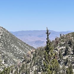
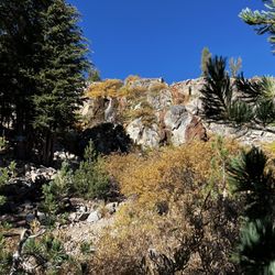
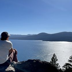
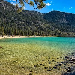
Quality/Quantity - Something for everyone! For both locals and tourists; well the tourists I feel out number us.... Views of Lake Tahoe, Sierras, Washoe Lake (yes quite a ways of a hike), Incline Lake (I have not been yet), etc. Winter - Sledding, cross country, snow shoeing, hiking, snow mobile, etc. Summer - Hiking, biking, etc. The path is 1.4 miles with only a 78ft elevation. It should take you no more than an hour. Only certain parts of the trail are ADA friendly. And of course, feeding the chickadees; bird seeds only please!! Do NOT give them "human" food. They will literally eat out of your hands. A great experience for all ages. Overall, very easy trails. But if you want to keep going, there are more challenging ones that you can connect to. We do not come here often enough... Ambiance - Beautiful and user friendly! Road parking, be safe. And please do NOT run across 431, wait for NO traffic before crossing! A place to drop off your snow mobiles, etc. Oh, and now I am starting to see food trucks?!?! NO restrooms or services. If available, you can drive a mile to Mt Rose Summit to see if the public restrooms are open. Service - Self service. Price - Free. Owner Comment - Thank you to the team at Tahoe Rim Trail Association, a 501(c)(3) nonprofit for maintaining this beautiful area. read more


One of the most unique experiences at Lake Tahoe! I've snowshoed here twice now and will always recommend this trail to visitors. Make sure you bring some bird seeds and be on the lookout for chickadees (or other people doing the same)! They will fly directly into your palm! At the ridge, there are also some great views, especially if it's a clear day. The whole trail is about 2-2.5 miles out and back and very beginner friendly! read more

More info about Chickadee Ridge
Incline Village, NV 89704
Directions
Hours
Outdoor Amenities
You might also consider


Chickadee Ridge - hiking - Updated May 2026
Best of Incline Village
People found Chickadee Ridge by searching for…
Free Sledding in Incline Village, Nevada
Snow Park in Incline Village, Nevada
Tubing in Incline Village, Nevada
Dog Sledding in Incline Village, Nevada
Lakes in Incline Village, Nevada
Snow Tubing in Incline Village, Nevada
Beautiful Views in Incline Village, Nevada
Sledding Hill in Incline Village, Nevada
Snow Play in Incline Village, Nevada
Sleigh Rides in Incline Village, Nevada
Scenic Overlook in Incline Village, Nevada
Scenic View in Incline Village, Nevada
Snow Sledding in Incline Village, Nevada
Night View in Incline Village, Nevada
Fun Things to Do in Incline Village, Nevada
Hiking Trails in Incline Village, Nevada
Walking Trails in Incline Village, Nevada
Off Road Trails in Incline Village, Nevada
Running Trails in Incline Village, Nevada
Easy Hikes in Incline Village, Nevada
Places to Walk at Night in Incline Village, Nevada
Lakes & Ponds in Incline Village, Nevada
Trending Searches in Incline Village, NV
Botanical Gardens near Chickadee Ridge
Bounce House Rentals near Chickadee Ridge
Campgrounds near Chickadee Ridge
Cherry Picking near Chickadee Ridge
Cliff Jumping near Chickadee Ridge
Dog Friendly Things To Do near Chickadee Ridge
Flower Fields near Chickadee Ridge
Flower Shop near Chickadee Ridge
Garage Sales near Chickadee Ridge
Garden Center near Chickadee Ridge
Lakes & Ponds near Chickadee Ridge
Nurseries & Gardening near Chickadee Ridge
Outdoor Activities near Chickadee Ridge
Outdoor Furniture Stores near Chickadee Ridge
Party Equipment Rentals near Chickadee Ridge
Photo Spots near Chickadee Ridge
Pick Your Own Farms near Chickadee Ridge
Picnic Areas near Chickadee Ridge
Places To Take Pictures near Chickadee Ridge
Rock Quarry near Chickadee Ridge
Running Trails near Chickadee Ridge
Strawberry Picking near Chickadee Ridge
Sunrise View near Chickadee Ridge
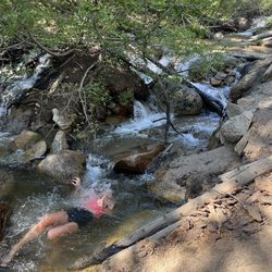
Swimming Holes near Chickadee Ridge
Table And Chair Rentals near Chickadee Ridge
Browse Articles
Browse Nearby
BEST of Incline Village, Nevada Restaurants near Chickadee Ridge
BEST of Incline Village, Nevada Coffee near Chickadee Ridge
BEST of Incline Village, Nevada Things to Do near Chickadee Ridge
BEST of Incline Village, Nevada Beaches near Chickadee Ridge
BEST of Incline Village, Nevada Breakfast near Chickadee Ridge
BEST of Incline Village, Nevada Shopping near Chickadee Ridge
BEST of Incline Village, Nevada Campgrounds near Chickadee Ridge
BEST of Incline Village, Nevada Hotels near Chickadee Ridge
BEST of Incline Village, Nevada Sledding near Chickadee Ridge
Browse Brands
Related Searches in Incline Village, NV
Affordable Kayak Rental Services in Incline Village, Nevada
Affordable Sled Rental Options in Incline Village, Nevada
Affordable Snow Rental Options in Incline Village, Nevada
Best Fishing Locations and Guides in Incline Village, Nevada
Best Places for Horseback Riding in Incline Village, Nevada
Best Ski Rental Deals and Shops in Incline Village, Nevada
Best Sledding Spots and Fun in Incline Village, Nevada
Best Snowboard Rental Services in Incline Village, Nevada
Best Snowmobile Rental Deals Near Incline Village, Nevada
Best Waterfalls and Swimming Holes in Incline Village, Nevada
Book Exciting Dog Sled Rides in Incline Village, Nevada
Book Exciting Snowmobile Tours in Incline Village, Nevada
Book Professional Ski Lessons Today in Incline Village, Nevada
Check Out Great Playgrounds in Incline Village, Nevada
Check Out Off Road Trails in Incline Village, Nevada
Discover Dog Friendly Trails to Explore in Incline Village, Nevada
Discover Fun Winter Activities in Incline Village, Nevada
Discover Kid Friendly Hiking Trails in Incline Village, Nevada
Discover Scenic Mountain Bike Trails Near Incline Village, Nevada
Discover Scenic Waterfall Spots in Incline Village, Nevada
Discover Top Snowshoeing Adventures in Incline Village, Nevada
Discover a Hiking Trail in Incline Village, Nevada
Discover the Best Night Hike Trails in Incline Village, Nevada
Discover the Best Snow Park Activities in Incline Village, Nevada
Dog-Friendly Hikes With Dogs in Incline Village, Nevada
Enjoy Camping Adventures Around Incline Village, Nevada
Enjoy Cross Country Skiing Adventures in Incline Village, Nevada
Enjoy Exciting Mountain Biking Adventures in Incline Village, Nevada
Enjoy Free Sledding Spots Around Incline Village, Nevada
Enjoy Hiking Adventures in Incline Village, Nevada
Enjoy Kayaking Adventures in Incline Village, Nevada
Enjoy Popular Snow Activities in Incline Village, Nevada
Enjoy Snow Play Areas and Fun in Incline Village, Nevada
Enjoy Tent Camping Spots Around Incline Village, Nevada
Enjoy a Beautiful Waterfall Hike in Incline Village, Nevada
Enjoy the Best Picnic Spots and Ideas in Incline Village, Nevada
Enjoy the Best Skiing Experiences Around Incline Village, Nevada
Enjoy the Best Tubing Experiences in Incline Village, Nevada
Enjoy the Best Walking Path in Incline Village, Nevada
Enjoy the Best Walking Trails in Incline Village, Nevada
Enroll in Kids Ski Lessons Around Incline Village, Nevada
Exciting Snow Tubing Experiences in Incline Village, Nevada
Experience Scenic Gondola Rides in Incline Village, Nevada
Experience Thrilling Snowmobiling in Incline Village, Nevada
Experience Thrilling White Water Rafting in Incline Village, Nevada
Explore Beautiful Parks and Green Spaces in Incline Village, Nevada
Explore Easy Hikes Perfect for All in Incline Village, Nevada
Explore Free Snow Play Areas in Incline Village, Nevada
Explore Fun Activities to Do in Incline Village, Nevada
Explore Kids Snow Park Activities in Incline Village, Nevada
People who viewed Chickadee Ridge also viewed
Mt Rose Hike
26 reviews
Spooner Lake
18 reviews
Tahoe Rim Trail to Picnic Rock Viewpoint
16 reviews
Whale Beach Trail
2 reviews
Lake Tahoe Nevada State Park - Memorial Point
24 reviews
Mt Rose Summit
22 reviews
Truckee Legacy Trail - Glenshire
13 reviews
Lake Margaret
13 reviews
Tahoe City Lakeside Trail
2 reviews
Incline Flume Trailhead
3 reviews