Cataract Falls State Recreation Area Photos


More like Cataract Falls State Recreation Area
Recommended Reviews - Cataract Falls State Recreation Area
Start your review...

Reviews With Photos

Crazy to think this area is just about an hour from Indy and I never knew. The guy working the entrance booth was friendly and incredibly helpful. He anticipated all of my questions in advance and gave me quick easy directions to all the highlights of the park. I loved that the parking lot and Upper Falls observation deck area are paved and fairly easily accessible. There are several areas where you can grill and we saw lots of people walking dogs. The park area is beautiful. I was disappointed to see how much graffiti was on the covered bridge despite lots of signs warning against it, but it was still pretty cool overall.

We love visiting this park! Largest waterfall in Indiana. There is a neat path from the upper falls to the lower falls, or easy parking in both sections if you don't want to walk. The Indiana parks do not have trash cans - you are asked to please carry out your own trash, so please bring a trash bag and keep this park beautiful.

I've been meaning to get here for years - one bright spot if COVID is getting us all to rediscover our state parks, parks and what's already in our backyard. The Cataract bridge was built in 1876 over what is known as Indiana's largest waterfall (ha, or the Niagara of Indiana). It's no Niagara but we were impressed by the strength and sound of the upper falls. From the upper falls parking lot, we hiked our way down to the lower falls. I believe it was around 40-45 minutes round trip. Note that it can be a bit slick after a rain. You can also choose to drive up to the lower falls. Picnic benches were found in both spots. If you're in need of an activity that makes you feel "elsewhere" this is a great pick! Note that McCormick Creek State Park is only 15 minutes down the road.

For a few years now Cataract Falls occasionally gets recommended on 'Only In Indiana' on my FB, and seeing it's not far from our family in Indiana's home we knew we had to go! We arrived on a weekday morning and to my surprise it's a state park and they charge $7. for residents and I believe it was $10. for out of state. It was nice to see we pretty much had the park to ourselves and the littles could move about without people to be respecting distancing (during COVID-19 breakout). I have to say Cataract Falls was pretty disappointing. The pictures I've seen online must have been taken by a professional photographer that either had a telephoto lens on their camera or they got access to restricted area to take the pictures. We were so far away and it was kind of boring. It is a pretty park though. All in all, I'm happy I crossed it off my list and we made memories with the kids on the ride there and back.

Cataract Falls had good signage getting off the interstate & was easy to get to. There's more parking at the Upper Falls than the Lower falls. Even though there's a lot of signs to not get close to the water, many people do (and that's what makes it fun!) Bring your good camera (you'll regret it if you don't), a picnic lunch (plenty of picnic tables) & long pants (it's easy but fun to get off the beaten path here). We spent almost our whole time here at Upper Falls & as a couple with no kids, we had a blast hiking up the heights & jumping over rocks. We drove down to Lower Falls just to see what it looks like -- it seems to be more of the family spot. Lots of people with kids, several people fishing, even one guy in a kayak. We didn't use the restroom facilities here, but they were available in a few locations. I love that we have waterfalls in Indiana. Take advantage!!!

Cataract Falls is just gorgeous! With everyone eager to bust out of quarantine, it was pretty busy when we visited last week BUT it's easy to maintain social-distancing here! There is a parking lot for both the upper and lower falls. In fact, the falls are very easy to see - there is little hiking involved to get to them so it's easily accessible. The red covered bridge is also very accessible and makes for a great photo background. There were quite a few fishing the day we were there. We sat and watched the bring in fish after fish near the lower falls. There are several trails available and picnic tables as well. I would suggest packing a picnic and enjoying it at one of the tables that overlook the upper falls! Outhouses are also available at both the upper and lower falls. A quick tip: bring your own hand sanitizer and or water/soap to use.


Cataract Falls is a park of rebels, as the signs tell you not to swim or climb the rocks, yet on our visit that is exactly what everyone was doing. Needless to say, we joined in the rebellion. While I agree that the 1/2-mile hiking trail is short, my husband and I made the most of our recent trip by walking through parts of the creek and behind the waterfall at the upper falls. The extra time spent doing these activities with the hiking to both falls rounded our visit to about three hours. It's a picture-esque spot, perfect for a day trip if you're looking for a little bit of adventure outside of Indy.


Waterfalls in Indiana? Who would've thought?? We ended up going on quite a rainy day and when we got back to the car, it was equivalent to getting out of a pool because we were completely drenched! But I've got to say the rain scared away the other visitors and we ended up being the only ones there for over an hour and had the whole place to ourselves! So I definitely recommend finding a rainy day if you don't mind getting a little wet!! Now for the actual attraction, the waterfalls were incredible!! The pictures really don't do the view justice because you really need all 360 degrees to SOAK it all in. Really, we kind of hiked around and found ourselves at the top of the upper falls, which I really recommend because you need the entire waterfall experience! It was actually pretty simple though, the path next to the falls is pretty straightforward and leads you to the top (unfortunately, there's not much direction on how to navigate the hiking trails). But apparently during winter when the upper falls are frozen, there's a path underneath that you can explore if you dare! All of the falls were accessible by car with no entry or parking fees when unmanned. Can't say I have much advice on how to stay dry, but be sure to pack a snack!

Late April 2020, world is on full quarantine; cabin fever is at an all time high! All this being said....there was no entry fee, the weather was beautiful and Spring was finally here. This park offered us more than we were ready for. Now that we have visited we have certain ideas for a better visit next time. YES THERE WILL BE A "NEXT" TIME!!! A covered bridge greets guests immediately; but take note that you aren't admitted past the end of the bridge. Of course you can be "those" people that jump the fence and to each his own on that note. A children's playground is straight across from the entrance just to ensure kiddos WILL NOT want to do anything else but run for it immediately! There weren't places to camp; however people were making use of the picnic tables conveniently placed close enough to the water for easy cleaning of the fish they caught, or simply an afternoon snack with the family. Hiking from the Lower Falls to the Upper Falls is roughly rugged at times depending on whom wants to trek down the rocky shores to skip rocks or fish. Just remember to bring along some water because you might find yourself rather thirsty. Once we got to the Lower Falls there were amazing fishermen catching in the double digits of fish! Not exactly sure even how on earth they really got there with their gear; or if they swam all the way there. All in all we will definitely drive to the Lower Falls first next time, and park. Taking our fishing poles first to fish. For once we made it to the Lower Falls there was no way myself and my kids were hiking all the way back to the car to start fishing. It easy to lose time along these rocky shores along the river as you visualize the way the Indians did years and years ago.........

How can you not give five stars to the largest water falls in Indiana. Amazingly and I am not sure how I missed this all these years. I have been to most all state parks and sights of interest since living in Indiana for 46 years. There is plenty to see here and I recommend you start by parking in the big lot when you enter. There are upper and lower falls. The lower falls is a short one mile hike. There is one steep decline down of maybe 25 ft. Then a leisurely stroll along the river. Eventually you'll get to the viewing area. That's when I saw another parking lot right by the falls. So if you don't want to hike there you can drive up. It is pretty and Indiana isn't really known for waterfalls so this is as good as it gets. My daughter and I had a good time. Most likely something to do once to check off your pars of Indiana list. I did pass a nice ice cream place in an old school house nearby so there are a few other things to see there as well.

I've heard so many great things about this park / waterfall, so I came in with a bit more expectations of the park. Sadly, this park has SO much potential, but they don't utilize the open space at all. I came in with the mindset of doing some hiking and enjoying the waterfall, but there's only a TINY hiking trail that takes you from the Upper Falls to the Lower Falls. At most a 1/2 mile long. That's it. There is a road that you can take with your vehicle if you didn't want to hike, so we took that road back to our car. We stopped at both of the falls for quite a few minutes, and we walked the entire park and experienced it all in about 50 minutes. It's hard to reason spending the exact same amount of money at this park to enter compared to others with 1000s of acres of green space and miles of hiking trails / camping / other outdoor activities. I'd love to see this place grow as the woods that are by the road going back to the Lower Falls are stunningly beautiful, so there's definitely potential. It's just a matter of creating some hiking trails and creating a map! Hope to see some necessary additions and changes to this park in the future. The falls are beautiful.

2 months ago
What a wonderful place to get out of the city and just slow down! My honey took me here 4/26/26 since we've had some nice weather lately. Pleasantly surprised they have many picnic tables, the cover bridge to see and of course the Falls. Just be careful when walking to the lower fall as you are pretty close to the ledge of the falls. Plenty to enjoy here. Next time we shall have a nice picnic and enjoy the scenery. You can swim too.Parking is easy but i'm sure it gets crowded in the summer time! read more


11 months ago
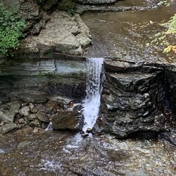
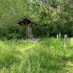
Cataract Falls is a geological wonder worth visiting and only an hour west of Indianapolis. These magnificent Falls were created over millions of years as ice and water carved into the ancient limestone resulting in Mill Creek and two sets of falls. The Upper Falls drops 20 feet and can be viewed near the entrance to the park at several overlooks. We visited this week on a bright summer day. The waters were loud and rapid after recent rains. This is one of Indiana's most beautiful sites. There is a large parking lot near the Upper Falls along with picnic tables, grill, pavilion and small playground. We brought a picnic lunch so we could enjoy the Falls. There are pit bathrooms near the playground in a second parking lot. The Lower Falls are a short drive through the park. A nearby lot provides plenty of parking. The short path to view the falls is not paved, but an easy walk. These falls drop 18 feet with incredible views of the layered limestone exposed west of the falls. I was envious of a lone kayaker below the falls. There are marked trails through dense woods descending near the creek. You'll want to wear good hiking shoes and bug spray if you are up for the adventure. The property was donated by Agnes Stuckey in memory of her mother, Agnes Steiner. The Park is maintained by the Indiana DNR. There was no admission during our midweek visit. read more


2 years ago
Crazy to think this area is just about an hour from Indy and I never knew. The guy working the entrance booth was friendly and incredibly helpful. He anticipated all of my questions in advance and gave me quick easy directions to all the highlights of the park. I loved that the parking lot and Upper Falls observation deck area are paved and fairly easily accessible. There are several areas where you can grill and we saw lots of people walking dogs. The park area is beautiful. I was disappointed to see how much graffiti was on the covered bridge despite lots of signs warning against it, but it was still pretty cool overall. read more


We love visiting this park! Largest waterfall in Indiana. There is a neat path from the upper falls to the lower falls, or easy parking in both sections if you don't want to walk. The Indiana parks do not have trash cans - you are asked to please carry out your own trash, so please bring a trash bag and keep this park beautiful. read more


5 years ago
I've been meaning to get here for years - one bright spot if COVID is getting us all to rediscover our state parks, parks and what's already in our backyard. The Cataract bridge was built in 1876 over what is known as Indiana's largest waterfall (ha, or the Niagara of Indiana). It's no Niagara but we were impressed by the strength and sound of the upper falls. From the upper falls parking lot, we hiked our way down to the lower falls. I believe it was around 40-45 minutes round trip. Note that it can be a bit slick after a rain. You can also choose to drive up to the lower falls. Picnic benches were found in both spots. If you're in need of an activity that makes you feel "elsewhere" this is a great pick! Note that McCormick Creek State Park is only 15 minutes down the road. read more


6 years ago
For a few years now Cataract Falls occasionally gets recommended on 'Only In Indiana' on my FB, and seeing it's not far from our family in Indiana's home we knew we had to go! We arrived on a weekday morning and to my surprise it's a state park and they charge $7. for residents and I believe it was $10. for out of state. It was nice to see we pretty much had the park to ourselves and the littles could move about without people to be respecting distancing (during COVID-19 breakout). I have to say Cataract Falls was pretty disappointing. The pictures I've seen online must have been taken by a professional photographer that either had a telephoto lens on their camera or they got access to restricted area to take the pictures. We were so far away and it was kind of boring. It is a pretty park though. All in all, I'm happy I crossed it off my list and we made memories with the kids on the ride there and back. read more


Cataract Falls had good signage getting off the interstate & was easy to get to. There's more parking at the Upper Falls than the Lower falls. Even though there's a lot of signs to not get close to the water, many people do (and that's what makes it fun!) Bring your good camera (you'll regret it if you don't), a picnic lunch (plenty of picnic tables) & long pants (it's easy but fun to get off the beaten path here). We spent almost our whole time here at Upper Falls & as a couple with no kids, we had a blast hiking up the heights & jumping over rocks. We drove down to Lower Falls just to see what it looks like -- it seems to be more of the family spot. Lots of people with kids, several people fishing, even one guy in a kayak. We didn't use the restroom facilities here, but they were available in a few locations. I love that we have waterfalls in Indiana. Take advantage!!! read more


Cataract Falls is just gorgeous! With everyone eager to bust out of quarantine, it was pretty busy when we visited last week BUT it's easy to maintain social-distancing here! There is a parking lot for both the upper and lower falls. In fact, the falls are very easy to see - there is little hiking involved to get to them so it's easily accessible. The red covered bridge is also very accessible and makes for a great photo background. There were quite a few fishing the day we were there. We sat and watched the bring in fish after fish near the lower falls. There are several trails available and picnic tables as well. I would suggest packing a picnic and enjoying it at one of the tables that overlook the upper falls! Outhouses are also available at both the upper and lower falls. A quick tip: bring your own hand sanitizer and or water/soap to use. read more


6 years ago
Shouldn't have waited so long to come! 1 hr from Lebanon Going to stop at oasis on way back in plainfield. read more

9 years ago
Cataract Falls is a park of rebels, as the signs tell you not to swim or climb the rocks, yet on our visit that is exactly what everyone was doing. Needless to say, we joined in the rebellion. While I agree that the 1/2-mile hiking trail is short, my husband and I made the most of our recent trip by walking through parts of the creek and behind the waterfall at the upper falls. The extra time spent doing these activities with the hiking to both falls rounded our visit to about three hours. It's a picture-esque spot, perfect for a day trip if you're looking for a little bit of adventure outside of Indy. read more


Beautiful scenery but can get crowded. There is only one trail so once you walk that there is not much to do. The trails can get crowded so try and go earlier in the day. Bring water shoes if you want to walk along the creek. read more

8 years ago
Waterfalls in Indiana? Who would've thought?? We ended up going on quite a rainy day and when we got back to the car, it was equivalent to getting out of a pool because we were completely drenched! But I've got to say the rain scared away the other visitors and we ended up being the only ones there for over an hour and had the whole place to ourselves! So I definitely recommend finding a rainy day if you don't mind getting a little wet!! Now for the actual attraction, the waterfalls were incredible!! The pictures really don't do the view justice because you really need all 360 degrees to SOAK it all in. Really, we kind of hiked around and found ourselves at the top of the upper falls, which I really recommend because you need the entire waterfall experience! It was actually pretty simple though, the path next to the falls is pretty straightforward and leads you to the top (unfortunately, there's not much direction on how to navigate the hiking trails). But apparently during winter when the upper falls are frozen, there's a path underneath that you can explore if you dare! All of the falls were accessible by car with no entry or parking fees when unmanned. Can't say I have much advice on how to stay dry, but be sure to pack a snack! read more


6 years ago
Late April 2020, world is on full quarantine; cabin fever is at an all time high! All this being said....there was no entry fee, the weather was beautiful and Spring was finally here. This park offered us more than we were ready for. Now that we have visited we have certain ideas for a better visit next time. YES THERE WILL BE A "NEXT" TIME!!! A covered bridge greets guests immediately; but take note that you aren't admitted past the end of the bridge. Of course you can be "those" people that jump the fence and to each his own on that note. A children's playground is straight across from the entrance just to ensure kiddos WILL NOT want to do anything else but run for it immediately! There weren't places to camp; however people were making use of the picnic tables conveniently placed close enough to the water for easy cleaning of the fish they caught, or simply an afternoon snack with the family. Hiking from the Lower Falls to the Upper Falls is roughly rugged at times depending on whom wants to trek down the rocky shores to skip rocks or fish. Just remember to bring along some water because you might find yourself rather thirsty. Once we got to the Lower Falls there were amazing fishermen catching in the double digits of fish! Not exactly sure even how on earth they really got there with their gear; or if they swam all the way there. All in all we will definitely drive to the Lower Falls first next time, and park. Taking our fishing poles first to fish. For once we made it to the Lower Falls there was no way myself and my kids were hiking all the way back to the car to start fishing. It easy to lose time along these rocky shores along the river as you visualize the way the Indians did years and years ago......... read more


How can you not give five stars to the largest water falls in Indiana. Amazingly and I am not sure how I missed this all these years. I have been to most all state parks and sights of interest since living in Indiana for 46 years. There is plenty to see here and I recommend you start by parking in the big lot when you enter. There are upper and lower falls. The lower falls is a short one mile hike. There is one steep decline down of maybe 25 ft. Then a leisurely stroll along the river. Eventually you'll get to the viewing area. That's when I saw another parking lot right by the falls. So if you don't want to hike there you can drive up. It is pretty and Indiana isn't really known for waterfalls so this is as good as it gets. My daughter and I had a good time. Most likely something to do once to check off your pars of Indiana list. I did pass a nice ice cream place in an old school house nearby so there are a few other things to see there as well. read more


I've heard so many great things about this park / waterfall, so I came in with a bit more expectations of the park. Sadly, this park has SO much potential, but they don't utilize the open space at all. I came in with the mindset of doing some hiking and enjoying the waterfall, but there's only a TINY hiking trail that takes you from the Upper Falls to the Lower Falls. At most a 1/2 mile long. That's it. There is a road that you can take with your vehicle if you didn't want to hike, so we took that road back to our car. We stopped at both of the falls for quite a few minutes, and we walked the entire park and experienced it all in about 50 minutes. It's hard to reason spending the exact same amount of money at this park to enter compared to others with 1000s of acres of green space and miles of hiking trails / camping / other outdoor activities. I'd love to see this place grow as the woods that are by the road going back to the Lower Falls are stunningly beautiful, so there's definitely potential. It's just a matter of creating some hiking trails and creating a map! Hope to see some necessary additions and changes to this park in the future. The falls are beautiful. read more


I'm not sure how good the directions on the website are. (In fact, the non-helpful website is the reason I give it only 4 stars.) But there's another website that might give even better information: http://gowaterfalling.com/waterfalls/cataractindiana.shtml In the meantime, the falls are spectacular! There's easy car-access to all the sites of interest, in case you're older or have kids in tow. But you can also hike it. The woods are beautiful. read more


12 years ago
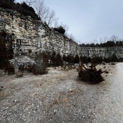
Pretty damn sweet and mostly undiscovered. I know people who live down the road in Bloomington and Spencer who complain about the lack of scenery in Indiana but have never even heard of Cataract Falls, so I refuse to take these people seriously. One of the best parks in Indiana if you ask me. I'm glad it's not swarming with tourists. Best time to visit is after a big thunderstorm or during the spring snow melts. Mill Creek seems like a tiny creek upstream and downstream, but I've seen it as a raging torrent, and the falls so loud you can barely hear. Not much to see if it hasn't rained in a while, but the park is always nice. There are actually three waterfalls here. The one by the parking lot where you come in is where most people stop. The Lower Falls are deeper in the park and have a really great sunset view of an open valley stretching downstream toward Lieber State Park. Little Sister Falls is normally dry, but a great area to hike around in the springtime (the area gets extremely overgrown during the summer.) There's also a covered bridge and the ruins of an old mill that sat right next to the Upper Falls. The view from the observation area up by the parking lot is all right, but your best bet is to jump the fence and walk down to the base of the falls. It's a little dangerous and slippery, but well worth it if you're cautious. And I've never, ever seen any park officials around. (The entrance station was unmanned every time I've been in the park.) I've walked back into the ledge underneath the falls when there wasn't a ton of water coming over the top, and it's a hell of a site. I think there's a few camping sites here, but if you're ever biking through, the place is pretty remote. Easy to gorilla camp out in the woods. Really cool pine forests in the park, too. Not your typical southern Indiana forest. Feels like something farther north. It's not Yosemite Falls, but I've had some truly beautiful evenings here and think Cataract Falls is one of the greatest parks in this underrated state. Don't worry about it being crowded, not even in the peak fall tourist season. No fancy amenities, no concessions, no problem. A couple of basic latrines. Pack a snack. read more


This is the largest waterfall in the state of Indiana! Alas that is about all you get when you come here. About 15 minutes south of Cloverdale, the park is simple. Pull into the entrance drive and a guard shack will take your admittance money and then you can park right there at the falls! Not much walking needed at all. We didn't see any trails, but you could probably walk down to the lower falls. No overnight camping is permitted, so this is just a picnicking and sightseeing location. It seems the State of Indiana could improve this area somehow, not sure why you have to pay an entrance fee at this time because facilities are minimal. read more

10 years ago
Oh my water !!!! I'm an Aquarius, which is the sign of the water bearer. Needless to say water is my thing. Whether it's a lake or an ocean, a puddle or a river, I love water. Sometime in the winter, I stumbled upon an article that had a link to all of the waterfalls in Indiana. I'm not sure how I missed it, having lived here my entire 30plus years, but Indy has some really impressive overflows of water. Cataract Falls, the biggest water (?) is at the top of that list and was the one I put my finger on and said as soon as it warms up outside, I need to be there!!! Well we made it and oh emm gee how incredible it was !!!!!! There are trails all over the place. The park was easy to find and there is decent parking space. We went on a Sunday. It usually costs between 7-9 bucks per car/truck to get in but since the office is closed on Sundays, it was free ! Perfect start! There is a covered bridge that you can cross to get to the right side of the river. I'm not sure what river this is, but there's a lot of it. The waterfall is beautiful ! We immediately climbed down to get as close to it as possible after seeing other people nearby do the same thing. Once we were down by the fall, we took pictures and stared into space but the hiking adventure set sail ! See, this is one of those waterfalls that you can stand behind if you find the right trail to take you there. The water stretches for miles and I believe we could walked forever and seen this beautiful stream as it calmed the further we went, but we had our heart set on sharing a kiss behind this Fall. And so we crossed the covered bridge, which I've never done before, and began our trek through the woods to find a way to the falls. About an hour (or easily 40 mins) later, after climbing up and then all the way down, we found out !!! ! There were people already there, people behind us and people across from us on the other side of the river. It was marvelous ! Like some type of best kept secret in Cataract, Indiana ! The waterfall was loud, beautiful and misted us just enough to give us a cool down (it was HOT). Now, despite getting a tid bit lost on the way back, we were able to find ourselves back to our starting point after conquering the waterfall (we didn't chase it....we hunted it. TLC would be proud). We had a blast. I love how you can sit in many different areas close to the water and even stick your feet in if that's your thing (not me). It's a great area for family, for reading, exercising and exploring. I will absolutely be back. I feel there is more left to conquer. And who wouldn't want to frequent a waterfall they can literally stand behind and share a kiss !!!!?!?!?!?!?! read more


When you can look back at an entire day and think "wow, I needed that ...," you know you've encountered a true gem. Cataract Falls is the gem of Cloverdale, IN, and I am so thankful that I was invited on a little day trip to visit the upper and lower falls. I had no idea what to expect and was surprised at all of the exploring and scenic views that were found upon our arrival. This area oozed out this feeling of calmness and sure, it might have had to do with the constant pouring of water and the birds - and the fact that we were there on a beautifully sunny day. But with all things combined, I was definitely in a happy place that day. Would I visit again? Most definitely. My biggest recommendation would be to wear water shoes. I wore boat shoes (you know, the kind of shoes that don't necessarily scream high fashion) and they worked perfectly. read more


Cataract Falls is the largest volume waterfall in Indiana. Located near Cloverdale, the park was easy to find by taking I-70 west to Exit 41, then turning south for about 7 miles to N Cataract Road and following along to the park entrance. I pulled up to the gate/office, but since it was February, it was unmanned. Fortunately, the website says that as long as it is daylight, park admission is free if the gate is untended. So, I pulled ahead and selected the path to the right (east) for the Upper Falls. There was a large parking lot available. Before approaching the falls, I decided to check out the Cataract Falls Covered Bridge. The bridge is no longer used as the main entrance to the park, but remains in place with the help of some timely restoration. The first covered bridge was destroyed by the flood of 1875. The only county bridge to survive that flood was one that used the Smith Truss instead of the usual Burr Arch. So when bids for a new bridge were solicited in 1876, it was decided to go with the Smith Truss that was manufactured in Toledo, Ohio, then assembled on site. Just north of the covered bridge is the Upper Falls area of Cataract Creek (Just south of Alpine Lake). There is a break wall that spans the entire river front where water drops only a few feet. The water then rushes forward and has a moderate drop along two main sections of the river. The water collects and then drops about 20 feet (the upper falls) to be carried more calmly down the river. The Lower Falls are roughly a half mile to the west of the Upper Falls. I decided to drive the distance, stopping at the picnic area about half the way there. The picnic area is located on a single lane road to the north of the main road. The area is very primitive and overlooks Cataract Creek in a relatively calm area. There is a slight drop of about a foot that provides a nice murmur. Note that wading is not allowed. The Lower Falls are much more accessible without the fences that block the proximity of the Upper Falls. This makes it easier to move around to get a better view. Much like the Upper Falls, there are some smaller drops across the river leading up to the bigger drop at the finish. The height of the Lower Falls is about 18 feet. Overall, the creek drops about 80 feet over the length of the recreation area. Even though there hadn't been much rain in February, there was still plenty of water flowing on the day I went. For those interested, there is some hiking available. By the main gate/entrance, there is also a playground for kids. Once again, Indiana has a well maintained, fun, and scenic park to add to the destinations worth visiting. North Cataract Road, Owen County Open: Sun up to Sun down The Park office during the season is open from 9 am until 5 or 6 pm. Cost: $5 per vehicle, unless the office is unmanned. It is okay to enter for free as long as the park is open when unattended Review #223 read more


5 years ago
A must see in Indiana! The park was open with no entree fee. This trail has a parking lot, bathrooms, playground, picnic tables and an historic covered bridge at the trailhead. You can see the upper falls from the parking lot when you arrive. We took our 13 and 10 year old boys and twin 10 month old girls on this trail. We carried our twins in our front packs. There is a pretty steep incline at the beginning of the trail heading to the lower falls. Aside from that the trail was pretty level. You also have a paved road option. I saw cars drive on the road that leads from the upper falls and covered bridge area to the lower falls. The park has a look-out point at both the upper and lower falls. The lower falls has a restroom and picnic tables available as well. We went on a Wednesday afternoon and it was not busy at all. Our boys enjoyed climbing down the hill to get a closer look at the water. The water was really moving fast so use extreme caution. If you fall in, your not going to make it out alive. Sadly, the trail was pretty littered in areas with cigarettes and water bottles. We packed a picnic and sat at one of the tables near the water and covered bridge. Overall, this was an excellent trail for our skill level and family. It's a must see for Indiana! read more


8 years ago
This is the largest waterfall in Indiana!! It is gorgeous! There are two sections; the upper and lower falls. There is plenty of hiking around the falls as well. It's a little bit in the middle of no where but absolutely worth the drive. It is not something you should swim in so if that's what you're looking for then try somewhere else. But beautiful views! read more


5 years ago
We visited a week after a heavy rainfall so there would be plenty of water over the falls. My kids really enjoyed being able to hike and explore different areas of the upper and lower falls. It was a nice afternoon adventure. I was disappointed to see all of the trash people left behind. Be sure to check out the Cataract Schoolhouse for some ice cream, it's about a mile down the road. read more


7 years ago
Easily accessible parking and picnic area. Foot access down to the falls. Restrooms are not handicapped accessible. Trash must be taken out read more


9 years ago
9 years ago
A must see if you enjoy the great outdoors, there's two separate water falls, a picnic area, a general store and a lodge. We went in the winter so the amenities were closed but still enjoyed the scenic views. read more

6 years ago
8 years ago
6 years ago
6 years ago
9 years ago
This place is gorgeous! Walked to the upper falls first and walked around then went behind the waterfall... there were several people there but it wasnt crowded and it was easy to enjoy time with family! We drive to the lower falls (we thought about walking but thankful we did not, it would have took a long time to walk, but just a couple minutes to drive). We all decided we would go back again, very enjoyable, next time we will go early in the day, bring a cooler lunch & plan to go canoeing! read more


5 years ago
9 years ago
9 years ago
Page 1 of 2
More info about Cataract Falls State Recreation Area
Cataract, IN 47460
Directions
Hours
Indoor Amenities
Outdoor Amenities
Ask the Community - Cataract Falls State Recreation Area
Review Highlights - Cataract Falls State Recreation Area


Why does Yelp recommend reviews?
Cataract Falls State Recreation Area - hiking - Updated July 2026
Best of Cataract
People found Cataract Falls State Recreation Area by searching for…
Things to Do in Cataract, Indiana
Campgrounds in Cataract, Indiana
Places to Take Pictures in Cataract, Indiana
Swimming Holes in Cataract, Indiana
Attractions in Cataract, Indiana
Fishing Spots in Cataract, Indiana
Hiking Trails With Waterfalls in Cataract, Indiana
Dog Parks in Cataract, Indiana
Swimming Lakes in Cataract, Indiana
Sunset View in Cataract, Indiana
Photo Spots in Cataract, Indiana
Scenic Drive in Cataract, Indiana
Watch Sunset in Cataract, Indiana
Fishing Lakes in Cataract, Indiana
Tourist Attractions in Cataract, Indiana
Scenic View in Cataract, Indiana
Things to Do on a Rainy Day in Cataract, Indiana
Hiking With Kids in Cataract, Indiana
Browse Nearby
Browse Brands
Browse Articles
People who viewed Cataract Falls State Recreation Area also viewed
McCormick's Creek State Park
55 reviews
Morgan-Monroe State Forest
21 reviews
DePauw Nature Park
10 reviews
Lieber State Recreation Area
13 reviews
Fred And Dorothy Meyer Nature Preserve
3 reviews
Lake Lemon Conservancy District
6 reviews
Friendship Gardens
7 reviews
Bob Ward Park
2 reviews
Antler Log Cabins Vacation Rentals
15 reviews
Bicentennial Park
3 reviews