Morgan-Monroe State Forest Photos


You might also consider
More like Morgan-Monroe State Forest
Recommended Reviews - Morgan-Monroe State Forest
Start your review...

Reviews With Photos

Morgan Monroe State Forest is a gem that I don't think enough people 1) experience and 2) give enough credit to. Over the last year or so, I've gone down from Indy a couple of times to check out the longer trails. First, the Low Gap Trail and most recently, the Three Lakes Trail. The trails were all very well marked with easy signage on the trees. There were a couple of times in which it was tricky to find the trail cause of random side trails but Google Maps was happy to help us get back on the trail. The Three Lakes Trail was a great trail when I most recently came by myself. The trail winds thru the forest among a variety of terrain - some times near a lake, some times among pine trees, creek beds, etc. I will add that there were a few times that I was absolutely terrified of coming across a snake cause the trail gets so narrow in so many places and there is a lot of brush pushed up against the trail in the summertime. Of course, it's humid summer so bugs were present but it wasn't something my Buff couldn't handle. I was lucky enough to only come across two people the entire trip. The Three Lakes came out to take me around 3 hours and 50 minutes and my Fitbit said it was around 9.77 miles. There were lots and lots of mushrooms along the trails as you can see in my photos. The one thing I would recommend was that due to a recent storm, there were about 20-30 trees down among the trail. Hopefully those get cleaned up soon. Aside from that, I can't wait to get back down and go backpacking and hiking along the trails some time soon!

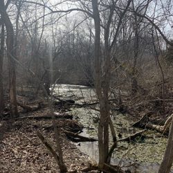
This 24,000 acre park doesn't have the best signs directing you to the park, but using a GPS seems to help. Most of the roads are winding and generally are in good shape, but some are gravel and so you may have to watch for potholes. I managed to find my way to the headquarters which seems to be as good a place as any to get oriented to any trail maps you may be using. I came in from the north end and passed the Lookout Tower and playground that are nearby. The headquarters wasn't open on Sunday morning, but it looks new and in great shape. I will definitely need to check it out on a future visit. Just north of the HQ, I grabbed one of the trail maps from a kiosk and headed to the Tree Identification Trail. The trail is rated as a one mile Easy trail that uses markers to identify numbers that match the printout I had from the website. Some of the markers were easy to find, but I didn't find them all. Also, some markers didn't seem to match the identification. Note that many of the trees are really tall, so seeing the leaves is not as easy as I had hoped. Maybe binoculars would be handy. The trail was wet from rains during the week, so I would suggest that the trail went from Easy to Moderate due to the muddy conditions and risk of slipping. I definitely recommend bringing a change of shoes and socks so that you don't have to worry about getting your car trashed from the mud! There is a lot of wildlife in the area. The trails were obviously used by local deer. The trail got really narrow at times so it was easy to spot the hoof prints for long stretches. Two highlights for me were the small box turtle crossing the Gose Creek Road and the deer that crossed the main road ahead of me. It waited in the tall undergrowth long enough for me to stop and take a photo from my car. Due to the wet conditions, I was uncomfortable hiking the longer trails. I started hiking the Mason Ridge Trail, but thought it best to wait for better conditions to attempt the nearly 3 mile loop. Review #2612

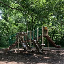
This is an underrated recreation area. There is great hiking, including a five mile paved trail for walking and biking. The primitive campground has nice secluded spots. It's quiet, unlike rowdy campgrounds like Paynetown. There are very clean vault toilets and an outdoor sink available. There is also a playground near the entrance of the campground. It's first come first serve: meaning you set up camp, then go to the camp office to register. If they are closed, there is a drop box to pay for the night. It's $12 a night.

I am sure this is a fine forest as far as forests go, but my visit here was solely for the creepy AF, "supposedly" (no, it really is...) haunted, 200+ year old Stepp Cemetery. I lived in Indiana for 15yrs and spent a solid 10 of those yrs going down to Btown from Indy. I remember so many Halloweens spent listening to stories about legit Indiana haunts and always believing my friends (and the webpages they referenced) were Hoosier whackadoos. The Stepp Cemetery was always mentioned and several of my friends always tried to get to go, but 1) I am a straight-out unashamed scaredy-cat 2) I am super sensitive to spiritual juju 3) I have seen Blair Witch Project...I know better. But, on a recent trip to visit a friend who had been one who had always wanted to go, I finally gave in (with the caveat that we went during the day, unlike at night as she suggested). We compromised on "dusk". Glad we decided to give ourselves a time buffer because Old IN 37 was closed for construction and in the Hoosier spirit of incompetence, the "detour" they provided ended on the other closed side of the construction, so we had no entrance access from there. Google maps to the rescue! Actually, the only real way to find the pull off and trail to Stepp is to follow the GPS as it is not marked and there is not a sign visible from the road. You know you are there because the of the single metal bar gate. The trail to Stepp is not a far one (maybe just over a quarter of a mile), but it sure is ominous. The trees are overgrown above the trail creating a sort of tunnel that in any other atmosphere would be splendid or romantic, but here...ominous. The grounds are marked by a headstone that actually says "Stepp Cemetery" and I did not initially feel weirded out when we first arrived. We were really surprised to see we were completely by ourselves as this seemed to be a pretty active and happening spot for disenfranchised youths, EVP-ers, and other ghost-hunting types. The creep factor of having the place to ourselves was immediately palpable. The Cemetery grounds are actually really pretty and peaceful looking as it is in a roundish clearing with the sunlight almost spotlighting certain parts. There is a weeping willow in one corner (with gravemarkers underneath) and another very large tree almost smack-dabb in the center. Once you start strolling around and get into looking at the various markers (some are so old the writing has literally worn off, others have some how sunken into the ground so you can only see the tops, others are super duper tiny, while others are in weird shapes. There is even one w/what looks like cyrillic on it) it is nice. The weird tingles and neck-hairs standing on end did not start for me until I came in front of this creepy looking burnt out tree. I immediately walked away and started perusing some quasi-hidden headstones under some nearby trees and then my friend called me over to the "haunted stump". The legend has it that the woman who has a baby buried here watches over the grave from that stump (it is kinda chair-like) and that's why nothing grows out of it. Well the stump she called me over to see was pretty huge and had little things growing out of it, so it was definitely not it. As we continued exploring the grounds we came upon what had to be the baby's grave since there were tokens and trinkets scattered everywhere, even hanging from the tree. From what I had been told, you leave a token on the grave so that the spirits don't haunt you when you leave. My friend and I each left the oldest pennies (face-up) we could find! Right after we laid the pennies down both of us got a chill and just looked at each other and then looked to our right and that's when we saw THE stump. This thing was literally like a movie prop. It was black, worn, and just had this aura of foreboding melancholy and tragic condemnation. Needless to say, (after we got an obligatory pic) we steered clear. Behind the baby grave there is this little clearing and my friend found these huge mushrooms, so I came over to take a look and a picture. My friend was doing her "EVP" stuff and I had bent down for closer inspection when all of a sudden both of us froze. There was this weird echoed tap directly to the left of us. My friend yelled "We're not deer, don't shoot!" We both giggled and then we both heard what can only be described as the combination of trickling water and a simultaneous glugging sound. At that point, we were both scared out of our wits (it was definitely getting dusky) and bolted back to the car. I am not a runner or even a light jogger, but I made it back to the car in record time. My breathless friend came up a minute or so later yelling,"How could you leave me behind!?!". I explained that the rules of horror movies applied here: every (wo)man for themselves! We got in the car, shut and locked the doors, started the engine, but just kind of sat there shaking. I went to pull up Gmaps and...no signal!?

This is a great way to get outside. Everything from picnic areas, hiking trails, and campsite. There is a new building going up so I'm interested to see what that will be this summer! The park is pack in pack out...so be sure to pack a trash bag! Signs near the campsite were family friendly and I saw some newer playground equipment! The quite hours were also 11-7 which is great if you want to get some sleep! FYI The roads thru the park are better on the south side than the north end.

Took a "daycation" here over my spring break when the weather was amazing. Not all the trails were open due to them having to rebuild and clear debris. The trail I took was the Tecumseh short trail which is a 3 mile moderate course. Very beautiful scenery although everything was still dead from winter. I did run into a couple if park rangers and workers and they helped with anything I needed and gave me a map of the park in it's entirety. I will definitely be back for summer and fall to see changes in scenery.

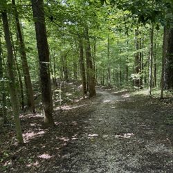
This state forest has two of my favorite longer day hikes within an hour of Indianapolis; The Low Gap Trail and The Three Lakes Trail. The Tecumseh Trail also runs through MMSF. In the last few years, a nice bike trail has been paved in and a new office built. There are also backcountry camping sites for primitive camping-be site to check in and practice leave no trace! The park does not have a lot of state park like amenities so be prepared to use a pit toilet. Bring your own tp and hand sanitizer just in case! The hikes are fairly challenging due to length and have some good hills. Bring plenty of water and keep an eye out for wildlife. Rattlesnakes have been spotted in the area. Hunting is also allowed in the state forest so wear bright colors at all times just in case. If you're looking for a challenging hike that is not overly populated but not totally isolated Morgan Monroe State Forest is an excellent choice. read more


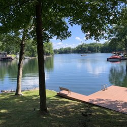
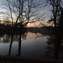
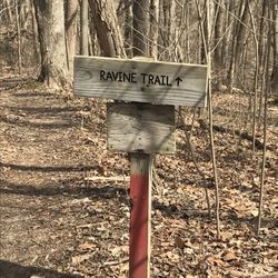
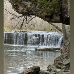
How had I never been here before? I love hiking, but somehow had missed this amazing spot until this past weekend. It's just a little over an hour drive from Indy, and on a beautiful, sunny Saturday in the spring with temps between the 60's and 70's, we did a delightful long hike here. We parked at the Cherry Lake Shelter parking area and did the Three Lakes Trail. The trailhead for the part of the trail that is the shorter path toward Bryant Lake is right off that parking lot, which is located down the hill by the Cherry Lake Shelter. Google maps does a good job getting you there if you just put in Cherry Lake shelter. If you want to do the more challenging part of the trail first, on fresher legs, I'd recommend doing what we did, and hike up the road you just drove down to get to the shelter and pick up the trailhead at the top of the hill which will do the longer and steeper part of the loop toward Bryant Lake first. The trail is rated Difficult/Rugged, but keep in mind this is "Indiana Rugged" not to be confused with mountain state rugged. Basically, the deal here is that there are some steep sections, decent elevation gain and loss (about 1200 feet up and then back down over the 10 or so miles of the trail). Hiking polls are a great help in saving knees on this trail and keeping balance on some of those steeper sections. There are also a bunch of rock hop/splash across water crossings, so waterproof hiking boots are a good idea to avoid soggy feet. Even after heavy rains, none were deep enough to go over our boots. There is nothing technically difficult or "scary" on this trail if you're at all used to hiking; the difficult/rugged rating seems primarily due to the length and the somewhat steep climbs and descents at times. The steep sections are all packed dirt; no loose gravel slopes which makes life much easier. As noted in every description of this trail, there are actually only two lakes; Cherry Lake and Bryant Lake; the third is now dry. Both are fairly large, and beautiful with lots of ducks, turtles and water lilies that were just getting started in very early May. There were a few people fishing and kayaking while we were there. Bryant Lake proved to be a great rest stop where we enjoyed a snack and just soaked up the scenery. There were a ton of butterflies and wildflowers along the trail, and not many people at all...this is definitely a less-visited area than the overcrowded state parks. I am definitely not the only hiker who has missed this spot. There is no charge to get in. Heads up that some forest roads look like they were maybe paved at one point, but are now mostly potholes and gravel. I did fine in a Subaru Forester going slow, but I would not try bringing any type of low clearance or low power vehicle here unless you very carefully plan routes in and out of the forest; the way Google maps routed me in was all paved and in good condition, until the last part down to the shelter parking area, but the way it routed me out was not anywhere near as nice. I definitely want to come back and do this trail again, and also the Low Gap Trail. I don't think I'd do a solo hike here given that it does not attract a lot of other hikers, is not very close to any main roads, etc and cell signal was weak/spotty. That said, these are the things that make it a great place to hike! I'll just always bring a buddy. No crowds, no loud talkers, just the sounds of nature. read more


Morgan Monroe State Forest is a gem that I don't think enough people 1) experience and 2) give enough credit to. Over the last year or so, I've gone down from Indy a couple of times to check out the longer trails. First, the Low Gap Trail and most recently, the Three Lakes Trail. The trails were all very well marked with easy signage on the trees. There were a couple of times in which it was tricky to find the trail cause of random side trails but Google Maps was happy to help us get back on the trail. The Three Lakes Trail was a great trail when I most recently came by myself. The trail winds thru the forest among a variety of terrain - some times near a lake, some times among pine trees, creek beds, etc. I will add that there were a few times that I was absolutely terrified of coming across a snake cause the trail gets so narrow in so many places and there is a lot of brush pushed up against the trail in the summertime. Of course, it's humid summer so bugs were present but it wasn't something my Buff couldn't handle. I was lucky enough to only come across two people the entire trip. The Three Lakes came out to take me around 3 hours and 50 minutes and my Fitbit said it was around 9.77 miles. There were lots and lots of mushrooms along the trails as you can see in my photos. The one thing I would recommend was that due to a recent storm, there were about 20-30 trees down among the trail. Hopefully those get cleaned up soon. Aside from that, I can't wait to get back down and go backpacking and hiking along the trails some time soon! read more


This 24,000 acre park doesn't have the best signs directing you to the park, but using a GPS seems to help. Most of the roads are winding and generally are in good shape, but some are gravel and so you may have to watch for potholes. I managed to find my way to the headquarters which seems to be as good a place as any to get oriented to any trail maps you may be using. I came in from the north end and passed the Lookout Tower and playground that are nearby. The headquarters wasn't open on Sunday morning, but it looks new and in great shape. I will definitely need to check it out on a future visit. Just north of the HQ, I grabbed one of the trail maps from a kiosk and headed to the Tree Identification Trail. The trail is rated as a one mile Easy trail that uses markers to identify numbers that match the printout I had from the website. Some of the markers were easy to find, but I didn't find them all. Also, some markers didn't seem to match the identification. Note that many of the trees are really tall, so seeing the leaves is not as easy as I had hoped. Maybe binoculars would be handy. The trail was wet from rains during the week, so I would suggest that the trail went from Easy to Moderate due to the muddy conditions and risk of slipping. I definitely recommend bringing a change of shoes and socks so that you don't have to worry about getting your car trashed from the mud! There is a lot of wildlife in the area. The trails were obviously used by local deer. The trail got really narrow at times so it was easy to spot the hoof prints for long stretches. Two highlights for me were the small box turtle crossing the Gose Creek Road and the deer that crossed the main road ahead of me. It waited in the tall undergrowth long enough for me to stop and take a photo from my car. Due to the wet conditions, I was uncomfortable hiking the longer trails. I started hiking the Mason Ridge Trail, but thought it best to wait for better conditions to attempt the nearly 3 mile loop. Review #2612 read more

 - Hiking Near Me - Martinsville, Indiana")


This is an underrated recreation area. There is great hiking, including a five mile paved trail for walking and biking. The primitive campground has nice secluded spots. It's quiet, unlike rowdy campgrounds like Paynetown. There are very clean vault toilets and an outdoor sink available. There is also a playground near the entrance of the campground. It's first come first serve: meaning you set up camp, then go to the camp office to register. If they are closed, there is a drop box to pay for the night. It's $12 a night. read more

I am sure this is a fine forest as far as forests go, but my visit here was solely for the creepy AF, "supposedly" (no, it really is...) haunted, 200+ year old Stepp Cemetery. I lived in Indiana for 15yrs and spent a solid 10 of those yrs going down to Btown from Indy. I remember so many Halloweens spent listening to stories about legit Indiana haunts and always believing my friends (and the webpages they referenced) were Hoosier whackadoos. The Stepp Cemetery was always mentioned and several of my friends always tried to get to go, but 1) I am a straight-out unashamed scaredy-cat 2) I am super sensitive to spiritual juju 3) I have seen Blair Witch Project...I know better. But, on a recent trip to visit a friend who had been one who had always wanted to go, I finally gave in (with the caveat that we went during the day, unlike at night as she suggested). We compromised on "dusk". Glad we decided to give ourselves a time buffer because Old IN 37 was closed for construction and in the Hoosier spirit of incompetence, the "detour" they provided ended on the other closed side of the construction, so we had no entrance access from there. Google maps to the rescue! Actually, the only real way to find the pull off and trail to Stepp is to follow the GPS as it is not marked and there is not a sign visible from the road. You know you are there because the of the single metal bar gate. The trail to Stepp is not a far one (maybe just over a quarter of a mile), but it sure is ominous. The trees are overgrown above the trail creating a sort of tunnel that in any other atmosphere would be splendid or romantic, but here...ominous. The grounds are marked by a headstone that actually says "Stepp Cemetery" and I did not initially feel weirded out when we first arrived. We were really surprised to see we were completely by ourselves as this seemed to be a pretty active and happening spot for disenfranchised youths, EVP-ers, and other ghost-hunting types. The creep factor of having the place to ourselves was immediately palpable. The Cemetery grounds are actually really pretty and peaceful looking as it is in a roundish clearing with the sunlight almost spotlighting certain parts. There is a weeping willow in one corner (with gravemarkers underneath) and another very large tree almost smack-dabb in the center. Once you start strolling around and get into looking at the various markers (some are so old the writing has literally worn off, others have some how sunken into the ground so you can only see the tops, others are super duper tiny, while others are in weird shapes. There is even one w/what looks like cyrillic on it) it is nice. The weird tingles and neck-hairs standing on end did not start for me until I came in front of this creepy looking burnt out tree. I immediately walked away and started perusing some quasi-hidden headstones under some nearby trees and then my friend called me over to the "haunted stump". The legend has it that the woman who has a baby buried here watches over the grave from that stump (it is kinda chair-like) and that's why nothing grows out of it. Well the stump she called me over to see was pretty huge and had little things growing out of it, so it was definitely not it. As we continued exploring the grounds we came upon what had to be the baby's grave since there were tokens and trinkets scattered everywhere, even hanging from the tree. From what I had been told, you leave a token on the grave so that the spirits don't haunt you when you leave. My friend and I each left the oldest pennies (face-up) we could find! Right after we laid the pennies down both of us got a chill and just looked at each other and then looked to our right and that's when we saw THE stump. This thing was literally like a movie prop. It was black, worn, and just had this aura of foreboding melancholy and tragic condemnation. Needless to say, (after we got an obligatory pic) we steered clear. Behind the baby grave there is this little clearing and my friend found these huge mushrooms, so I came over to take a look and a picture. My friend was doing her "EVP" stuff and I had bent down for closer inspection when all of a sudden both of us froze. There was this weird echoed tap directly to the left of us. My friend yelled "We're not deer, don't shoot!" We both giggled and then we both heard what can only be described as the combination of trickling water and a simultaneous glugging sound. At that point, we were both scared out of our wits (it was definitely getting dusky) and bolted back to the car. I am not a runner or even a light jogger, but I made it back to the car in record time. My breathless friend came up a minute or so later yelling,"How could you leave me behind!?!". I explained that the rules of horror movies applied here: every (wo)man for themselves! We got in the car, shut and locked the doors, started the engine, but just kind of sat there shaking. I went to pull up Gmaps and...no signal!? read more


This is a great way to get outside. Everything from picnic areas, hiking trails, and campsite. There is a new building going up so I'm interested to see what that will be this summer! The park is pack in pack out...so be sure to pack a trash bag! Signs near the campsite were family friendly and I saw some newer playground equipment! The quite hours were also 11-7 which is great if you want to get some sleep! FYI The roads thru the park are better on the south side than the north end. read more

11 years ago
Took a "daycation" here over my spring break when the weather was amazing. Not all the trails were open due to them having to rebuild and clear debris. The trail I took was the Tecumseh short trail which is a 3 mile moderate course. Very beautiful scenery although everything was still dead from winter. I did run into a couple if park rangers and workers and they helped with anything I needed and gave me a map of the park in it's entirety. I will definitely be back for summer and fall to see changes in scenery. read more

This is a favorite haunt of mine. I love taking a day off and just going on hikes. I usually will walk the Low Gap Trailhead or the Cherry Lake Trailhead. Both are great and worth the hike. This place is the home of the infamous Stepp Cemetery and has had heightened popularity in the past. Other than that, this is a great place to clear your head. Many picnic spots and restrooms as well. read more

9 years ago
9 years ago
9 years ago
11 years ago
12 years ago
More info about Morgan-Monroe State Forest
6220 Forest Rd
Martinsville, IN 46151
Directions
(765) 342-4026
Call Now
Hours
Outdoor Amenities
Other Amenities
Ask the Community - Morgan-Monroe State Forest
Review Highlights - Morgan-Monroe State Forest


Morgan-Monroe State Forest - hiking - Updated May 2026
Best of Martinsville
People found Morgan-Monroe State Forest by searching for…
Sledding in Martinsville, Indiana
Parks in Martinsville, Indiana
Fishing Spots in Martinsville, Indiana
Photo Spots in Martinsville, Indiana
Fishing Lakes in Martinsville, Indiana
Things to Do in Martinsville, Indiana
Hiking Trails in Martinsville, Indiana
Kayaking in Martinsville, Indiana
Scenic View in Martinsville, Indiana
Places to Take Pictures in Martinsville, Indiana
Marinas in Martinsville, Indiana
Secluded Spots in Martinsville, Indiana
Tulip Garden in Martinsville, Indiana
Long Term Rv Parking in Martinsville, Indiana
Baby Shower Locations in Martinsville, Indiana
Beautiful Views in Martinsville, Indiana
Camping Sites in Martinsville, Indiana
Ghost Tour in Martinsville, Indiana
Off Road Trails in Martinsville, Indiana
Night View in Martinsville, Indiana
Casinos in Martinsville, Indiana
Bait and Tackle Shop in Martinsville, Indiana
Trending Searches in Martinsville, IN
Botanical Gardens near Morgan-Monroe State Forest
Bounce House Rentals near Morgan-Monroe State Forest
Campgrounds near Morgan-Monroe State Forest
Cheap Plants near Morgan-Monroe State Forest
Cherry Picking near Morgan-Monroe State Forest
Cliff Jumping near Morgan-Monroe State Forest
Communal Shower near Morgan-Monroe State Forest
Dog Friendly Things To Do near Morgan-Monroe State Forest
Fishing Ponds near Morgan-Monroe State Forest
Flower Fields near Morgan-Monroe State Forest
Flower Shop near Morgan-Monroe State Forest
Garage Sales near Morgan-Monroe State Forest
Garden Center near Morgan-Monroe State Forest
Lakes near Morgan-Monroe State Forest
Lakes & Ponds near Morgan-Monroe State Forest
Long Term Rv Parking near Morgan-Monroe State Forest
Nurseries & Gardening near Morgan-Monroe State Forest
Outdoor Activities near Morgan-Monroe State Forest
Outdoor Furniture Stores near Morgan-Monroe State Forest
Parks near Morgan-Monroe State Forest
Party Boat near Morgan-Monroe State Forest
Party Equipment Rentals near Morgan-Monroe State Forest
Pedicure near Morgan-Monroe State Forest
Photo Spots near Morgan-Monroe State Forest
Picnic Areas near Morgan-Monroe State Forest
Picnic Spots near Morgan-Monroe State Forest
Places To Take Pictures near Morgan-Monroe State Forest
Pontoon Boat Rentals near Morgan-Monroe State Forest
River Tubing near Morgan-Monroe State Forest
Rock Quarry near Morgan-Monroe State Forest
Running Trails near Morgan-Monroe State Forest
Rv Dump Station near Morgan-Monroe State Forest
Rv Rental near Morgan-Monroe State Forest
Secret Spots near Morgan-Monroe State Forest
Spray Tanning near Morgan-Monroe State Forest
Sunrise View near Morgan-Monroe State Forest
Swimming Holes near Morgan-Monroe State Forest
Table And Chair Rentals near Morgan-Monroe State Forest
Browse Brands
Related Cost Guides
Related Searches in Martinsville, IN
Affordable Canoe Rental Options in Martinsville, Indiana
Affordable Fishing Rental Services in Martinsville, Indiana
Best Day Camps for Children in Martinsville, Indiana
Best Fishing Locations and Guides in Martinsville, Indiana
Best Fun Things to Do in Martinsville, Indiana
Best Off Leash Dog Parks in Martinsville, Indiana
Best Parks for Parties and Events in Martinsville, Indiana
Best Places for Horseback Riding in Martinsville, Indiana
Best Sledding Spots and Fun in Martinsville, Indiana
Best Summer Camps for Kids Located in Martinsville, Indiana
Best Water Parks for Kids in Martinsville, Indiana
Book Private Boat Charters for Trips in Martinsville, Indiana
Book Top Fishing Trips in Martinsville, Indiana Today
Browse Top Hotels in Martinsville, Indiana for Your Stay
Browse Vacation Rentals to Book in Martinsville, Indiana
Check Out Off Road Trails in Martinsville, Indiana
Discover Dog Friendly Trails to Explore in Martinsville, Indiana
Discover Exciting Adventure Options in Martinsville, Indiana
Discover Free Campgrounds in Martinsville, Indiana Area
Discover Fun Toddler Parks in Martinsville, Indiana for Your Little One
Discover Lakes & Ponds to Explore in Martinsville, Indiana
Discover Popular Photo Spots in Martinsville, Indiana
Discover Scenic Beach Camping Sites in Martinsville, Indiana
Discover Top State Parks to Visit in Martinsville, Indiana
Discover a Hiking Trail in Martinsville, Indiana
Discover the Best Beaches in Martinsville, Indiana
Discover the Best Fishing Lake in Martinsville, Indiana
Discover the Best Night Hike Trails in Martinsville, Indiana
Discover the Best Running Track in Martinsville, Indiana
Effective Stairs Workout Spots in Martinsville, Indiana
Enjoy Exciting Mountain Biking Adventures in Martinsville, Indiana
Enjoy Fishing With Kids in Martinsville, Indiana Safely
Enjoy Hiking Adventures in Martinsville, Indiana
Enjoy Tent Camping Spots Around Martinsville, Indiana
Enjoy a Relaxing Bed & Breakfast Experience in Martinsville, Indiana
Enjoy a Scenic Boat Ride in Martinsville, Indiana
Enjoy the Best Family Activities in Martinsville, Indiana
Enjoy the Best Tubing Experiences in Martinsville, Indiana
Enjoy the Best Walking Trails in Martinsville, Indiana
Explore Beautiful Parks and Green Spaces in Martinsville, Indiana
Explore Easy Hikes Perfect for All in Martinsville, Indiana
Explore Free Things to Do Around Martinsville, Indiana
Explore Mobile Home Parks in Martinsville, Indiana Now
Explore Popular Boat Charters Near Martinsville, Indiana
Explore Popular Campgrounds Near Martinsville, Indiana
Explore Popular Picnic Areas Around Martinsville, Indiana
Explore Scenic Lakes to Visit in Martinsville, Indiana
Explore Secret Spots Worth Visiting in Martinsville, Indiana