Cancel

Open app

Search

Blackhawk Fly Fishing

3.7 (3 reviews)
Open • 8:00 am - 5:00 pm

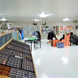
Blackhawk Fly Fishing Photos

Recommended Reviews - Blackhawk Fly Fishing

Your trust is our priority, so businesses can't pay to alter or remove their reviews. Learn more about reviews.
Yelp app icon
Browse more easily on the app
Review Feed Illustration

6 months ago

Helpful 0
Thanks 0
Love this 0
Oh no 0
Photo of Rick B.
45
46
5

10 years ago

Helpful 0
Thanks 0
Love this 0
Oh no 0

7 years ago

Helpful 0
Thanks 0
Love this 0
Oh no 0

Verify this business for free

People searched for Fishing 205 times last month within 15 miles of this business.

Verify this business

Moccasin Creek State Park - Lake view

Moccasin Creek State Park

4.0(2 reviews)
7.7 mi

My son and I went tent camping in Aug before his school started. Didn't realize how busy this…read moreplace was, but did manage to get one of the last two spots one week prior. The place met all our expectations, however one thing I didn't think about was how close the main road is to the campsites. So, being in a tent, you can easily hear all the traffic. The place seems to be more suited to RV campers since it's so close to the main road. But, at least the restrooms were never busy. The location is convenient to Hemlock Falls, but be aware walking there involves a trek just to get to the parking lot at Hemlock Falls. We opted to drive there, even though it's just across the street. We got spotty cell coverage at the campsite and could sometimes get one bar of signal. Though there is wifi at the office, its range is limited and is slow. Park is kept clean and restrooms are acceptable. The office maintains a stock of various supplies and prices are reasonable. Park is relatively small, but there are a number of things to do: playground, volleyball, basketball, horseshoes, kayak, canoe, paddle board, and fishing. Swimming is not really allowed. Highlight of our trip was laying on the dock at midnight and watching the shooting stars in the clear night.

A very nice place to stop This was along the route as we…read moredrove through the mountains looking for the change of leaves and the best place to view them. The road (SR 197) travels across or along several fingers of Lake Burton on its route to the mountains to connect up with I-76 on the north end. This campground is along the east side of the road and across from the Hemlock Falls trailhead entrance. It is situated along the lake with a beautiful view. The office is right up front on the right as you drive into the grounds. The staff were very friendly and helpful. The office is not very big. The park advertises that it sits on 32 Acres and has 53 tent, trailer & RV campsites, a boat Dock and ramp, a wildlife observation tower, a fishing Pier -- ADA accessible, and a playground. The office is a good place to check in for the campgrounds or to get a parking pass for seeing the falls. The grounds were well maintained and there was a large open-air pavilion situated right along the lake. Overall, it is s nice place to stop, seems a nice place to camp, and is convenient for those seeking to hike to Hemlock Falls.

Photos
Moccasin Creek State Park - The office

The office

Moccasin Creek State Park - Informational sign

Informational sign

Moccasin Creek State Park - Map

See all

Map

Turning Stone's Fly Fishing - Rainbow Trout

Turning Stone's Fly Fishing

4.0(7 reviews)
25.9 mi

I booked an afternoon trip for the East Fork of the French Broad River which is 30 minutes from…read morewhere I'm staying in Saphire, NC. My guide sends me instructions the night before to meet him 1:45 minutes away in the Nantahala Gorge. I now have to coordinate a different location because the East Fork is too far for him. So we settle on the Tuckaseegee River in Webster. The morning of the trip, he texts me and says his truck broke down and has to cancel the trip. I called Gordon who tells me he thinks he has another guide who can take me, and he'll call me one way or the other within 30-45 minutes. An hour later, I still don't hear from him but reach the guide who says he can meet a bit later. Gordon finally calls and gives me excuses as to why he didn't call me. But due to all the drama caused between coordinating with his guide the day before and the day of the trip, I was no longer in a happy frame of mind. So Gordon cancelled the trip. Birthday trip ruined. Don't use this company. It's too much hassle coordinating a trip. And Gordon has no idea how to handle a bad situation.

We had a great time with Turning Stone Fly Fishing. We went out with Jordan and he was a great…read moreguide and teacher. The beauty of the scenery he took us to was worth it alone. Add in all the fish we caught even not know how when we got there and you have a wonderful experience. Highly recommend and will be back again.

Photos
Turning Stone's Fly Fishing - Rainbow trout

Rainbow trout

Turning Stone's Fly Fishing

See all

Tallulah Gorge State Park

Tallulah Gorge State Park

4.5(209 reviews)
10.4 mi

Tallulah Gorge State Park is a 2,689-acre Georgia state park adjacent to Tallulah Falls, Georgia,…read morealong the county line between Rabun and Habersham Counties. The park surrounds Tallulah Gorge, a 1,000-foot deep gorge formed by the action of the Tallulah River, which runs along the floor of the gorge. Service options here are picnic tables available, has barbecue grill and it's dogs friendly. One of the most spectacular canyons in the eastern U.S., Tallulah Gorge is two miles long and nearly 1,000 feet deep. Visitors can hike rim trails to several overlooks, or they can obtain a permit to hike to the gorge floor (100 per day, not available during water releases). A suspension bridge sways 80 feet above the rocky bottom, providing spectacular views of the river and waterfalls. $5 parking fee or an Annual ParkPass is required for each vehicle. The park offers a range of trails, from easy rim walks to the more challenging trek down into the gorge floor. Permits are required for gorge floor access, but the effort is well worth it as you can get up close to the waterfalls, including the famous Hurricane Falls. Approximately 2 miles, round-trip Mulched with metal stairs, Rated difficult. This trail has a total of 1,099 stairs (including staircase to gorge floor). Please do not attempt this trail if you have any known health condition. The North and South Rim Trails consist of 3 miles round- trip which will take approximately 2 hours to hike. It is a mulched trail with exposed roots that is a leisurely walk. From the Interpretive Center there is a recycled rubber tire trail that accesses Overlooks 2 and 3. Overall had a great experience.

The visitor center is phenomenal! Movie was down for some reason. The gift shop has loads to choose…read morefrom and the rest rooms were clean and there were many stalls available. There is almost a museum quality to the taxidermy animal scene they have in the middle of the room and along the walls. Truly a special visit! The hike to see the inspirational point and the swinging bridge wasn't too strenuous for my 4 or 5 year old for people's reference when considering it. We are an active family who hikes etc. There were a lot of warnings but we found it wasn't as bad as it seemed.

Photos
Tallulah Gorge State Park
Tallulah Gorge State Park - 10.22 towards the S Rim 568 stairs up

10.22 towards the S Rim 568 stairs up

Tallulah Gorge State Park

See all

Smithgall Woods - Angel of Death Mushroom along the trail - one of the most poisonous in the world

Smithgall Woods

4.8(10 reviews)
11.0 mi

Venue Smithgall Woods State Park ( Smithgall Cottages) 5 out of 5 stars…read more After copious amounts of research and several venue tours, we decided on Smithgall Woods state park, and more specifically the cottages as the venue for our wedding on June 8th. We just have to say we loved the team we worked with at Smithgall, mainly Todd, Patty, and Art. Todd at Guestservices was simply fantastic! As he will be quick to mention "the venue sells itself", however having him as our man on the inside was a pretty huge selling point on its own. He was with us every step of the way to answer our plethora of questions, work with vendors, and generally keep our minds at ease. Honestly, I doubt the wedding weekend would have gone as smoothly and been as much of a success had it not been for Todd's guidance and cooperation. The venue is magical. I know how that sounds, but it's the truth. It's tucked away deep in the beautiful North Georgia mountains, surrounded by a lush forest teaming with wildlife. This majestic property consists of five "cottages", in quotations because they are more like log cabin style mansions. The two largest being; the expansive 4 bedroom 4.5 bathroom cottage called the Smithgall Cottage, and the even larger 5 bedroom 5 bathroom Dover cottage. The Creekside Cottage is 3 bedrooms, and The Laurel and Garden cottages are one bedroom cottages with hot tubs on secluded side porches. All the cottages were clean, modern, and a huge hit with our guests. We were able to house both our families, close friends and wedding party all on the same property. Which saved us a great deal on lodging. Which after factoring in the cost of rooms made this one of the more affordable wedding venues out there. Also you get it for the whole weekend!!! We used the Smithgall Cottage for our wedding location due to the large wrap around porch and decks, and also due to the picturesque, covered foot bridge under which flows a gorgeous champion trout stream. We had some difficulty deciding where on this property to hold our ceremony because it is simply lovely all over. Unfortunately, the record rainfall that weekend made the decision for us. Even though the storms limited our use of the enormous field in front of the Dover cottage, and the gardens next to Smithgall we still were able to comfortably host our 50 or so guests and dozen vendors, at the Smithgall Cottage and our ceremony and reception went along wonderfully. We would highly recommend this venue to anyone wishing to have a once in a lifetime event at a once in a lifetime location.

I came here to see the covered bridge, but discovered they have so much more…read more THE SCENE Smithgall Woods may not be someplace Georgians are familiar with, unless you are an avid hunter or trout fisherman. It was once private property that was gifted to the state by conservationist Charles A. Smithgall Jr. in 1994. A large section still remains private property for the Smithgall family, but what was gifted is a treasure trove of beautiful mountains, streams, meadow fields and wetlands. I began my solo hike around 12:15pm from the Visitors Center. There I was given a map and a few brief highlights of points of interest, like the waterfalls and gold mine. I then set off one what turned out to be a 4.5 hour adventure. Probably not the smartest of ideas since I had surgery just three weeks ago. But I was tired of resting around the house and desperately wanted to get out and do something. Besides, nature brings a calmness to my inner being and allows me to relax my mind in ways I just can't at home. It was a perfect day with perfect temperatures for hiking. In my entire time there, I only ran across one other human. ----- THE HIKE Inside the Visitor's Center is a gift shop and small wildlife museum of the nature plants and animals. I walked down the paved Tsalaki Trail towards the Cathy Ellis Trail (approximately 2.6 mile away). The trail starts off as a fairly steep incline. Along the way I saw a sign saying "caution - bees". I thought that was a curious warning until I noticed the white honey bee houses in the woods nearby. Next came the wetlands with a one mile looping trail and a boardwalk into the marshes. Here you have a strong possibility of seeing a beaver at work on a dam. I decided to save this area for my return hike and I'm glad I did. My energy on the return leg was running very low and I needed the benches here for a nice long rest. I reached the covered bridge about 37 minutes after leaving the visitors center. It was a real beauty made in the simple Town Lattice style. The memorial plaque at the entrance was titled "Bay's Bridge In loving memory of 'Bay' Elizabeth Smithgall Watts", whom died the year the land for the state park was gifted. It crosses the amazing mountain stream known as Duke's Creek. The creek from here will be a large part of your journey. The trail turns to gravel just past the bridge. MARTIN'S MINE was one of the first Gold mines in Georgia. Most of the mining occurred from 1829 to 1935. By the 1840's most of the easy gold was gone and hard mining began. Miners dug tunnels and shafts to remove ore from deep underground. You can still see some of the entrances and shafts. The trail is well marked with numbers, so be sure to pick up the Mining Trail brochure at the Visitor's Center to help you decode the locations. There is a spur trail off the Martin's Mine loop that takes you to a waterfall used for hydraulic mining, which began in the 1850's. It is an uphill hike, but the waterfall is very nice. Back on the main trail I traveled another 1/2 mile to Cathy Ellis Trail. This 1/2 mile trail starts off uphill, but once you reach the shelter it's all downhill from there. The trail ends at the beautiful Chunannee waterfall (which means friendship). Lots of vegetation on this portion of the hike. This land was once the home of Lucy Bryant, a Cherokee Indian widow whom was granted this 640 acre parcel in the Treaty of 1817. But by 1839 the Trail of Tear forced all Cherokee Indians off their land to relocate in Oklahoma. They curiously chose to name the trail after a 19 year old girl who fell over a waterfall in a different county altogether instead of the Indian widow Lucy. I don't get that, but whatever. The waterfall here is beautiful. I sat here about 25 minutes resting and admiring its beauty and feeling sad for the ancient Cherokee Indian nation. I arrived here approx. 2.5 hours after I began my journey from the visitors center. NOTE: Prior to arriving at the Cathy Ellis trail there is another steep incline, similar to the one near the Visitor's Center. ----- FINAL THOUGHTS In total I hiked approximately 7.5 miles today. I would normally have done this in probably 3 hours, but I tried to go at an easier pace since I'm still recovering from surgery. I allowed myself plenty of places to sit and rest, the most enjoyable of them being the waterfall on the Cathy Ellis Trail. Smithgall Woods State Park is indeed a wonderful place for those who love nature and peaceful hiking venues. I HIGHLY RECOMMEND giving them a visit.

Photos
Smithgall Woods - Beautiful state park

Beautiful state park

Smithgall Woods - Visitor's Center

Visitor's Center

Smithgall Woods - Bay's Covered Bridge

See all

Bay's Covered Bridge

Blackhawk Fly Fishing - fishing - Updated May 2026

Loading...
Loading...
Loading...