Black Mountain Trail Photos


You might also consider
More like Black Mountain Trail
Recommended Reviews - Black Mountain Trail
Start your review...

Reviews With Photos

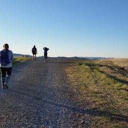
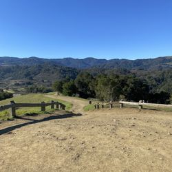
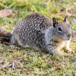
Very challenging hike in Rancho San Antonio County Park. There are two ways to access Black Mountain. The shorter of the two is to start in the Rhus Ridge parking lot off of Rhus Ridge Road. This parking is very small, so its best to come early in the morning or later in the day. The other way to access this trail is from the PG&E trail from the main parking lot. This route is a lot longer and more strenuous than accessing the trail from Rhus Ridge Road. From the Rhus Ridge trailhead, the summit is around 4.5- 5 miles each way. The first mile and the last mile of this trail is very steep and strenuous. The middle portions of the trail was either flat or very gradual incline. The hike up to the summit is gorgeous. At several points during the trail, you are able to have a beautiful view of the Bay Area below. I saw several deer crossing the trail at times. Once at the summit, the view is gorgeous, even though most of it is blocked by several trees. I would defiantly recommend this hike if you want a great workout.


Arrived on a foggy, misty morning a little after 9:30. There were still a couple spots in the small lot, likely thanks to the weather. I'd been hiking in the area before, but not this trail. The trail gets steep quickly, and though I haven't been on a long hike in some time I decided to dig in and get up that hill! Along the way you cross several other paths, got me thinking about stringing together a few trials to get 15-20 miles in next time. Anyway, the trial evens out a few times allowing you to catch your breath. There are several good spots for a nice few, and if you embrace the stillness of nature and keep your senses open you'll find lots of natural treasures along the way. Not gonna lie, the electrical tower at the top was not the vista I wanted, but the rest of the trial made up for it. The most exciting part was a bobcat sighting, she crossed the trial about 12-feet in front of me and we each got a good look at one another. I wanted to keep eye contact so I didn't grab my phone to take a pic, but I got several others. Just over 10-miles out & back in just under 3.5 hrs


Great hiking area with a decent amount of shade at peak hours. Several trails to choose from, some more strenuous than others. Even on a Wednesday at 11am the small lot at Rhus Ridge Trailhead was full so I parked at Foothill College. I got a good workout in under 2 hours, but could have gone longer if I had brought more water. The incline during most of the trail is good enough to make it a decent workout for the day. Scenery is great, even when cutting through residential areas past multimillion dollar homes (gave an extra kick to work harder when I return to the day job). This is my new workout/hiking area

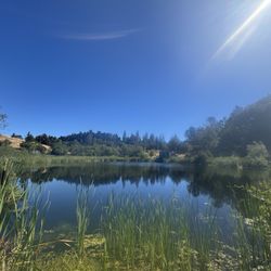
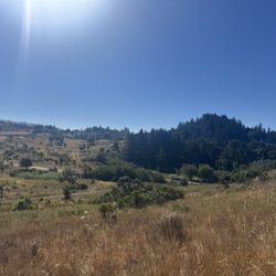
Activity Type: Hiking Nearby City: Los Altos Length: 10 total miles Elevation Gain: 2,412 feet Trail Type: Out-and-back Skill Level: Moderately strenuous Duration: 3 hours Season: Best mid-September through mid-May Trailhead Elevation: 400 Top elevation: 2,812 Having done the entire Rancho San Antonio and Black Mountain was a six hour ordeal. Total 17 miles plus or minus. One difference is we took the Quarry Trail on the way up and to me it's the prettiest trail on the way to the top of Black Mountain from Rancho San Antonio. The trail is lined by gorgeous chaparral trees. Best view of 101. This is the most difficult undertaking among the three because of the length and of course the elevation gain. Very strenuous. I went back two days after and this time started from Rhus Ridge Trail. It's a total of 10 miles and a more direct approach and will skip the Quarry Trail. One note to remember this is mildly strenuous because it is shorter but you will gain 2,412 feet! The third and easiest trail is from Montebello parking area from Page Mill Rd. You will start at 2200 feet with a total hike of 2.5 miles. You will only gain about 612 feet. Pretty easy! Once you get to the top past the gate and after you reach the intersection make a right and then a left. You will find a rock outcropping and the USGS marker is there. That's the top officially! Golden grass hugs the land at the summit. It is amazing. The fog the day we went enveloped the land and kisses you gently as you climb continuously. On the summit there are two broadcasting stations. One is a private radio station owned by Stanford University, and the other is owned by the Federal Aviation Administration. There are several wineries along Montebello Road, including Ridge Vineyards, Fellom Ranch Vineyards and Picchetti Brothers Winery. The trails on the first two trail heads are both uphill. After you pass the Quarry Trail intersection it gets even worst. It's worth the pain you will feel after. After all it is local and I love how close it is to home!

I love this hike because it's local enough for me (not having to drive far), for the beautiful scenery, for the moderate level of difficulty and a nice view up top, especially if the day is clear and you can oversee the bay and familiar clusters of downtowns far away. I compete with myself to make the shortest time. I wouldn't call it a walk in the park, you need to be aware of the nature around you, and especially on a hot day. Almost stepped on a large rattle snake today (not really-:), I haven't seen one this size in all my years hiking here, took some pics of it, it was an impressive creature. Though I've seen some people with strollers, I would honestly advice against hiking with infants or toddlers in tow.

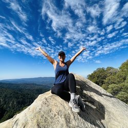
Of all the hikes I have checked out in the South Bay (though limited sample size), Black Mountain Trail is probably one of the best ones for many reasons. This trail is one of the many paths in the greater Rancho San Antonio Open Space Preserve and it's the path you would take to get to the Black Mountain Summit. First off, I would not suggest this hike for people who are just in it for the destination. The views are definitely gorgeous at the top of Black Mountain, but you aren't going to be at an extremely high altitude to see clouds or anything like that. This trail is mainly for people who have a thirst for challenge and want to enjoy the beautiful scenery on the way up. That said, definitely come here VERY early in the morning. The trailhead that I used was at Rhus Ridge road and can be accessible off Moody road from the 280 on either direction. It's very close by Foothill College so if you're around there, you are in the right place. If you are going to use that trailhead, it will probably be packed by 8. I am not sure about the Cristo Rey parking area; it might be better and I'd recommend it if it is. From the Rhus Ridge parking lot, you take Rhus Ridge path up about a mile before turning right and eventually hitting Black Mountain Trail. For those who do not hike often, this can be a challenge as the Black Mountain Trail is primarily uphill for about 4.5 miles until you hit the very top. If you stick with it, it's well worth it because there's a nice blend of both shade and scenery. Almost at every hilltop you can get a glimpse of the beautiful hills along the Peninsula. Without taking a break, it took me and my housemate about 1.5-2 hours to get to the top. On average, i'd say expect to take around 2 .5hours to make it to the peak and 1-1.5 hours to get back down. There's really not much of a "peak" as there is a clearing, but definitely take your time and enjoy the view. tl;dr overall, I think Black Mountain Trail is a really nice one for people living in South Bay. It's easily accessible and it's quite a challenge for both seasoned hikers and newbies a like. The only knock about this hike is that some of the parking lots can be horrendously small. Have fun and prosper,

Black mountain trail was a nice shaded hike. Me and my brother went exploring while I was on spring break (one of the perks of working in a school). I thought that it would be really crowded and we wouldn't find any parking but there was plenty. I can see how it would be busy over the weekend. We rolled in at about 3:30 PM and it was really nice outside not too hot and perfect amount of shade. It Starts out with a moderately steep incline But there are many places to stop and look out and appreciate the view. I will be coming back here again!

Minus one star because the view is boring, even when you get up to the rocks. Minus another star because it doesn't loop around. Once you go up, you just go back down. It's a good workout though. Not many people either. Small parking area. Free parking. If you like privacy come here but it seems dead. Probably won't be coming back. Just a bucket list type of hike Rancho San Antonio is probably still nicer but the PG&E Trail gets boring too...these places are only good if you want a close local nearby South Bay hike but are too lazy to drive out further. I went on a Fri around noon so it was pretty chill. Try it out if you just wanna make it up to the top, there are also other paths that branch out to PG&E, Hidden Villa, etc Oh yeah the address to get here is: Rhus Ridge Rd Los Altos, CA 94022 https://goo.gl/maps/Xy2X8DaSfvB2 Just keep going and you'll see a lil parking area on your right
This is a nice hiking trail that I didn't know about until now. I went hiking on this trail on Black Friday instead of shopping. There's online shopping available so there's no need to go to the stores. We hiked early in the morning at 5:00am so it was very cold. Actually, it was freezing cold. Thank god, I came prepared. I had my hydration pack, 2 layers of jackets, thick leggings, and shoes with traction. If you plan to hike this trail, wear shoes with traction because slipping and falling will not be fun at all... On the hike up, it was quite dark so I didn't really get to enjoy the scenery but I did see stars and that was nice because I don't get to see it as often as I want to. The hike was pretty steep. Mission Peak got nothing on this hike! I could feel my butt and hamstrings working. lol. It was a total of 10.6 miles... I was told it was just 10 round trip but it was almost 11 miles! It's okay because I got a good workout out of it. Once, I got to the top, the view was beautiful. It kinda felt like I was in a movie and in a middle of a field with the sunlight shining on me. If it had flowers or daisies...I would have to run through it like in the movies. lol. The hike up was a little more challenging but the hike down wasn't too bad. I definitely wanna come back to Black Mountain but with a buddy so I don't get lost on my own.

12 days ago


3 months ago
This trail is challenging. Proceed only if you can handle elevation of uphill all the way for the first appro. 1 mile. We started off at rhus ridge trailhead. Trail was steep and mostly in shade. Nice valley view along the way to look at and you can see the bay afar. Very quiet and unpopular trail. At many points, you'd feel there's only you and your companion in the whole mountain. There's a warning sign of mountain lion but we didn't see any, not that I wanted to. :) Recommend to use hiking stick. It'd take about 4 hours to complete the whole trail. If you walk slower it'd be longer. read more


1 year ago
Very challenging hike in Rancho San Antonio County Park. There are two ways to access Black Mountain. The shorter of the two is to start in the Rhus Ridge parking lot off of Rhus Ridge Road. This parking is very small, so its best to come early in the morning or later in the day. The other way to access this trail is from the PG&E trail from the main parking lot. This route is a lot longer and more strenuous than accessing the trail from Rhus Ridge Road. From the Rhus Ridge trailhead, the summit is around 4.5- 5 miles each way. The first mile and the last mile of this trail is very steep and strenuous. The middle portions of the trail was either flat or very gradual incline. The hike up to the summit is gorgeous. At several points during the trail, you are able to have a beautiful view of the Bay Area below. I saw several deer crossing the trail at times. Once at the summit, the view is gorgeous, even though most of it is blocked by several trees. I would defiantly recommend this hike if you want a great workout. read more


We had a great hike here early on a weekend. I did not where to park, so that was a challenge but we finally made it to the trail. Did not make it all the way to the top but got some great photos of the valley and the hills along with a decent workout. read more


8 years ago
Arrived on a foggy, misty morning a little after 9:30. There were still a couple spots in the small lot, likely thanks to the weather. I'd been hiking in the area before, but not this trail. The trail gets steep quickly, and though I haven't been on a long hike in some time I decided to dig in and get up that hill! Along the way you cross several other paths, got me thinking about stringing together a few trials to get 15-20 miles in next time. Anyway, the trial evens out a few times allowing you to catch your breath. There are several good spots for a nice few, and if you embrace the stillness of nature and keep your senses open you'll find lots of natural treasures along the way. Not gonna lie, the electrical tower at the top was not the vista I wanted, but the rest of the trial made up for it. The most exciting part was a bobcat sighting, she crossed the trial about 12-feet in front of me and we each got a good look at one another. I wanted to keep eye contact so I didn't grab my phone to take a pic, but I got several others. Just over 10-miles out & back in just under 3.5 hrs read more


4 years ago
Gorgeous trail with scenic views and you can catch sunset over the pacific. The trail ascends gradually and takes about 3-3.5 hours. We also saw deers prancing around which was fun! read more


Great hiking area with a decent amount of shade at peak hours. Several trails to choose from, some more strenuous than others. Even on a Wednesday at 11am the small lot at Rhus Ridge Trailhead was full so I parked at Foothill College. I got a good workout in under 2 hours, but could have gone longer if I had brought more water. The incline during most of the trail is good enough to make it a decent workout for the day. Scenery is great, even when cutting through residential areas past multimillion dollar homes (gave an extra kick to work harder when I return to the day job). This is my new workout/hiking area read more


Activity Type: Hiking Nearby City: Los Altos Length: 10 total miles Elevation Gain: 2,412 feet Trail Type: Out-and-back Skill Level: Moderately strenuous Duration: 3 hours Season: Best mid-September through mid-May Trailhead Elevation: 400 Top elevation: 2,812 Having done the entire Rancho San Antonio and Black Mountain was a six hour ordeal. Total 17 miles plus or minus. One difference is we took the Quarry Trail on the way up and to me it's the prettiest trail on the way to the top of Black Mountain from Rancho San Antonio. The trail is lined by gorgeous chaparral trees. Best view of 101. This is the most difficult undertaking among the three because of the length and of course the elevation gain. Very strenuous. I went back two days after and this time started from Rhus Ridge Trail. It's a total of 10 miles and a more direct approach and will skip the Quarry Trail. One note to remember this is mildly strenuous because it is shorter but you will gain 2,412 feet! The third and easiest trail is from Montebello parking area from Page Mill Rd. You will start at 2200 feet with a total hike of 2.5 miles. You will only gain about 612 feet. Pretty easy! Once you get to the top past the gate and after you reach the intersection make a right and then a left. You will find a rock outcropping and the USGS marker is there. That's the top officially! Golden grass hugs the land at the summit. It is amazing. The fog the day we went enveloped the land and kisses you gently as you climb continuously. On the summit there are two broadcasting stations. One is a private radio station owned by Stanford University, and the other is owned by the Federal Aviation Administration. There are several wineries along Montebello Road, including Ridge Vineyards, Fellom Ranch Vineyards and Picchetti Brothers Winery. The trails on the first two trail heads are both uphill. After you pass the Quarry Trail intersection it gets even worst. It's worth the pain you will feel after. After all it is local and I love how close it is to home! read more


I love this hike because it's local enough for me (not having to drive far), for the beautiful scenery, for the moderate level of difficulty and a nice view up top, especially if the day is clear and you can oversee the bay and familiar clusters of downtowns far away. I compete with myself to make the shortest time. I wouldn't call it a walk in the park, you need to be aware of the nature around you, and especially on a hot day. Almost stepped on a large rattle snake today (not really-:), I haven't seen one this size in all my years hiking here, took some pics of it, it was an impressive creature. Though I've seen some people with strollers, I would honestly advice against hiking with infants or toddlers in tow. read more


Of all the hikes I have checked out in the South Bay (though limited sample size), Black Mountain Trail is probably one of the best ones for many reasons. This trail is one of the many paths in the greater Rancho San Antonio Open Space Preserve and it's the path you would take to get to the Black Mountain Summit. First off, I would not suggest this hike for people who are just in it for the destination. The views are definitely gorgeous at the top of Black Mountain, but you aren't going to be at an extremely high altitude to see clouds or anything like that. This trail is mainly for people who have a thirst for challenge and want to enjoy the beautiful scenery on the way up. That said, definitely come here VERY early in the morning. The trailhead that I used was at Rhus Ridge road and can be accessible off Moody road from the 280 on either direction. It's very close by Foothill College so if you're around there, you are in the right place. If you are going to use that trailhead, it will probably be packed by 8. I am not sure about the Cristo Rey parking area; it might be better and I'd recommend it if it is. From the Rhus Ridge parking lot, you take Rhus Ridge path up about a mile before turning right and eventually hitting Black Mountain Trail. For those who do not hike often, this can be a challenge as the Black Mountain Trail is primarily uphill for about 4.5 miles until you hit the very top. If you stick with it, it's well worth it because there's a nice blend of both shade and scenery. Almost at every hilltop you can get a glimpse of the beautiful hills along the Peninsula. Without taking a break, it took me and my housemate about 1.5-2 hours to get to the top. On average, i'd say expect to take around 2 .5hours to make it to the peak and 1-1.5 hours to get back down. There's really not much of a "peak" as there is a clearing, but definitely take your time and enjoy the view. tl;dr overall, I think Black Mountain Trail is a really nice one for people living in South Bay. It's easily accessible and it's quite a challenge for both seasoned hikers and newbies a like. The only knock about this hike is that some of the parking lots can be horrendously small. Have fun and prosper, read more


3 years ago
7 years ago
Black mountain trail was a nice shaded hike. Me and my brother went exploring while I was on spring break (one of the perks of working in a school). I thought that it would be really crowded and we wouldn't find any parking but there was plenty. I can see how it would be busy over the weekend. We rolled in at about 3:30 PM and it was really nice outside not too hot and perfect amount of shade. It Starts out with a moderately steep incline But there are many places to stop and look out and appreciate the view. I will be coming back here again! read more


11 years ago
Minus one star because the view is boring, even when you get up to the rocks. Minus another star because it doesn't loop around. Once you go up, you just go back down. It's a good workout though. Not many people either. Small parking area. Free parking. If you like privacy come here but it seems dead. Probably won't be coming back. Just a bucket list type of hike Rancho San Antonio is probably still nicer but the PG&E Trail gets boring too...these places are only good if you want a close local nearby South Bay hike but are too lazy to drive out further. I went on a Fri around noon so it was pretty chill. Try it out if you just wanna make it up to the top, there are also other paths that branch out to PG&E, Hidden Villa, etc Oh yeah the address to get here is: Rhus Ridge Rd Los Altos, CA 94022 https://goo.gl/maps/Xy2X8DaSfvB2 Just keep going and you'll see a lil parking area on your right read more


This is a nice hiking trail that I didn't know about until now. I went hiking on this trail on Black Friday instead of shopping. There's online shopping available so there's no need to go to the stores. We hiked early in the morning at 5:00am so it was very cold. Actually, it was freezing cold. Thank god, I came prepared. I had my hydration pack, 2 layers of jackets, thick leggings, and shoes with traction. If you plan to hike this trail, wear shoes with traction because slipping and falling will not be fun at all... On the hike up, it was quite dark so I didn't really get to enjoy the scenery but I did see stars and that was nice because I don't get to see it as often as I want to. The hike was pretty steep. Mission Peak got nothing on this hike! I could feel my butt and hamstrings working. lol. It was a total of 10.6 miles... I was told it was just 10 round trip but it was almost 11 miles! It's okay because I got a good workout out of it. Once, I got to the top, the view was beautiful. It kinda felt like I was in a movie and in a middle of a field with the sunlight shining on me. If it had flowers or daisies...I would have to run through it like in the movies. lol. The hike up was a little more challenging but the hike down wasn't too bad. I definitely wanna come back to Black Mountain but with a buddy so I don't get lost on my own. read more


10 years ago
Nice, medium hike with clear path! View - the view varies from the part of the other you're on and can go from totally scenic to a nice view of the Bay and San Jose. On a sunny day you can see pretty far and up into the Los Altos hills. Some parts are pretty shady and tree-lined which keep you from getting too burnt. Difficulty - some of the hills from the Rhus road entrance are pretty tough and can be slippery on the way down but I would say medium for the most part. I saw strollers and some slower folks on the trail with no issues. Parking - parking is tricky. Make sure you park in an actual lot and not on the street. I saw one street parked car get a ticket. However, since the hike isn't super popular you're bound to find a spot in the lot. read more


16 years ago
18 years ago
14 years ago
14 years ago
13 years ago
Completed 11 miles today in about 3:20 with 3,500 ft elevation gain. Moderate/strenuous trail worth the ass jiggle burn but the view at the summit was somewhat disappointing. Sadly, I was expecting more. Still a great local hike for a workout to burn some C's. read more

11 years ago
10 years ago
12 years ago
14 years ago
11 years ago
11 years ago
11 years ago
Page 1 of 2
More info about Black Mountain Trail
Ask the Community - Black Mountain Trail
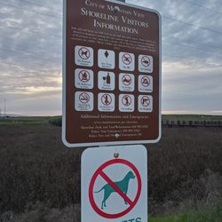
Where is the closest parking from El Monte access?
Google Street View shows that there's a small parking lot at the Rhus Ridge Trailhead off Rhus Ridge Road.
Would you recommend hiking this alone? I am from East Bay Area and do a 4 mile hike once twice a week with 2 miles being uphill. I am just not familiar with this area so not…
It's a safe hike to do alone, for girl or guy. Just be sure to take enough water. Lots of sun towards the top!
Review Highlights - Black Mountain Trail
You might also consider


Why does Yelp recommend reviews?
4 reviews that are not currently recommended
The reviews below are not factored into the business's overall star rating.
2 years ago
11 months ago
6 years ago
1 year ago
Black Mountain Trail - hiking - Updated July 2026
Best of Los Altos
People found Black Mountain Trail by searching for…
Hiking Trails in Los Altos, California
Dog Friendly Hiking Trails in Los Altos, California
Parks in Los Altos, California
Stargazing in Los Altos, California
Scenic Drive in Los Altos, California
Walking Trails in Los Altos, California
Shaded Hike in Los Altos, California
Scenic View in Los Altos, California
Running Trails in Los Altos, California
Watch Sunset in Los Altos, California
Easy Hikes in Los Altos, California
Scenic Places to Walk in Los Altos, California
Beautiful Views in Los Altos, California
Tourist Attractions in Los Altos, California
Secret Spots in Los Altos, California
Night View in Los Altos, California
View Points in Los Altos, California
Photo Spots in Los Altos, California
Things to Do in Los Altos, California
Trail in Los Altos, California
Stroller Friendly Hikes in Los Altos, California
Off Road Trails in Los Altos, California
Trending Searches in Los Altos, CA
Black Owned Nail Salons in Los Altos, CA
Cliff Jumping in Los Altos, CA
Dog Friendly Trails in Los Altos, CA
Jet Ski Rental in Los Altos, CA
Lakes & Ponds in Los Altos, CA
Off Road Trails in Los Altos, CA
Outdoor Activities in Los Altos, CA
Places To Walk Around in Los Altos, CA
Pool Day Pass in Los Altos, CA
Public Shower in Los Altos, CA
River Swimming in Los Altos, CA
Scenic Night View in Los Altos, CA
Scenic Overlook in Los Altos, CA
Secluded Spots in Los Altos, CA
Strawberry Picking in Los Altos, CA
Swimming Holes in Los Altos, CA
Browse Articles
Browse Nearby
BEST of Los Altos, California Restaurants near Black Mountain Trail
BEST of Los Altos, California Coffee near Black Mountain Trail
BEST of Los Altos, California Things to Do near Black Mountain Trail
BEST of Los Altos, California Walking Trails near Black Mountain Trail
BEST of Los Altos, California Parks near Black Mountain Trail
BEST of Los Altos, California Breakfast near Black Mountain Trail
BEST of Los Altos, California Hot Springs near Black Mountain Trail
BEST of Los Altos, California Campgrounds near Black Mountain Trail
BEST of Los Altos, California Sightseeing near Black Mountain Trail
Browse Brands
Related Searches in Los Altos, CA
Affordable Kayak Rental Services in Los Altos, California
Best Fishing Locations and Guides in Los Altos, California
Best Nature Trails for Hiking in Los Altos, California
Best Places for Horseback Riding in Los Altos, California
Best Waterfalls and Swimming Holes in Los Altos, California
Check Out Off Road Trails in Los Altos, California
Discover Dog Friendly Trails to Explore in Los Altos, California
Discover Kid Friendly Hiking Trails in Los Altos, California
Discover Scenic Hiking Trails in Los Altos, California
Discover Scenic Mountain Bike Trails Near Los Altos, California
Discover Scenic Waterfall Spots in Los Altos, California
Discover Walking Parks in Los Altos, California Near You
Discover a Hiking Trail in Los Altos, California
Discover the Best Night Hike Trails in Los Altos, California
Dog-Friendly Hikes With Dogs in Los Altos, California
Enjoy Camping Adventures Around Los Altos, California
Enjoy Exciting Mountain Biking Adventures in Los Altos, California
Enjoy Kayaking Adventures in Los Altos, California
Enjoy Tent Camping Spots Around Los Altos, California
Enjoy a Beautiful Waterfall Hike in Los Altos, California
Enjoy a Peaceful Nature Walk in Los Altos, California
Enjoy the Best Walking Path in Los Altos, California
Enjoy the Best Walking Trails in Los Altos, California
Exciting Cliff Jumping Spots in Los Altos, California
Experience Thrilling White Water Rafting in Los Altos, California
Explore Beautiful Parks and Green Spaces in Los Altos, California
Explore Easy Hikes Perfect for All in Los Altos, California
Explore Fun Activities to Do in Los Altos, California
Explore Popular Campgrounds Near Los Altos, California
Explore the Best Beach Spots in Los Altos, California
Explore the Best Trail Options in Los Altos, California
Family Friendly Hiking With Kids in Los Altos, California
Find Popular Ziplining Spots Around Los Altos, California
Find the Best Parks for Picnics in Los Altos, California
Find the Best Scenic View Locations in Los Altos, California
Great Places to Walk in Los Altos, California
Hike the Popular Waterfall Trail in Los Altos, California
Hiking Trails With Waterfalls in Los Altos, California
Off Leash Dog Hiking Trails in Los Altos, California
Plan a Scenic Drive Route Near Los Altos, California
Popular Outdoor Activities to Try in Los Altos, California
Popular Picnic Spots to Visit in Los Altos, California
Safe River Swimming Areas in Los Altos, California
Safe and Fun Parks for Kids in Los Altos, California
Top Climbing Spots and Gyms in Los Altos, California
Top Paddleboarding Activities in Los Altos, California
Top Running Trails to Explore in Los Altos, California
Top Swimming Spots and Pools in Los Altos, California
People who viewed Black Mountain Trail also viewed
Zinfandel Trail
9 reviews
Tony Look Trail
18 reviews
Maisie's Peak
10 reviews
PG&E Trail
21 reviews
Rancho San Antonio Preserve
778 reviews
Sunnyvale Bay Trail
27 reviews
San Tomas Aquino Creek Trail/Saratoga Creek Trail Reach 5
13 reviews
Skyline Trail
6 reviews
Byrne Preserve
7 reviews
Saratoga Gap Open Space Preserve
18 reviews