Stevens Creek Trail Photos


You might also consider
More like Stevens Creek Trail
Recommended Reviews - Stevens Creek Trail
Start your review...

Reviews With Photos

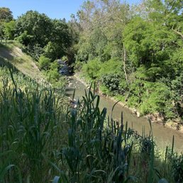
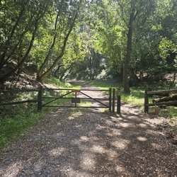
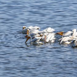
Be aware: The most commonly reviewed part of Stevens Creek Trail is the stretch from Landels Park and School on the south to Shoreline Park. A lesser known fragment of the trail exists between Stevens Creek Blvd to Linda Vista Park. I review these two pieces, and not the third stretch, which is a strenuous hiking trail that goes from the Stevens Creek Chestnut Parking Lot off Stevens Canyon Road up the Stevens Creek Trail through Stevens Creek Park past the Stevens Creek Spillway to the Stevens Creek Reservoir and the Stevens Creek Quarry to the Steven Creek Bathrooms where you can take a Stevens Creek Leak. Landels Elementary was a safe place to park and start the 3.2 miles toward Stevens Creek Shoreline Nature Study Area Preserve. Following the shallow creek, the path is relatively flat, straight, and shady, with no detectable change in elevation. Because it parallels the 85, passes by numerous transponders, crosses the 101 with a long bridge, and then splits Microsoft/Google and NASA, it is not as bucolic as Coyote Creek (separate review). That said, the smell of the landscape as you pass a tree nursery is surprising and refreshing. I am guessing it is eucalyptus and lemongrass, or a koala bear dusting furniture) What makes this trail better than the Los Gatos Creek trail (separate review) is that you have the option to ride a portion of the Bay Trail past the shoreline, with the wind-rippled bay on one side and mossy water on the other, both filled with waterfowl, like black-necked stilts, mallards, snowy and great egrets, great blue herons, cormorants, pintails, and maple-necked strats. OK, that last one is a guitar. Are they ponds? The ocean? I don't know, the sign said SLOUGH, so I decreased my speed. The view is a little surreal: half natural and half industrial but with barbed wire fences protecting Google and NASA's irregularly shaped buildings, with a few fighter jets taking off. Be warned: that trail has loose sand and constant cold winds- even in late June it was chilly. PART 2. The trail from Linda Vista Park to Stevens Creek Blvd is what Google Maps recognizes as the trail. It makes for a nice walk, but the trail was too short for a workout or leisurely ride worth packing the bikes, but also too dodgy for kids, unless you know what to expect. Parking at Linda Vista Park, we rode down an unpaved and slightly pebbly yet "flat" trail about 1/3 a mile between backyards and lawns/golf course to McClellan Road. The incline might be too much for kids- even with an electric bike you must brake going down and pump going up. Right before reaching the cross traffic of the desolate McClellan Road, the lane abruptly turns into a narrow S-curve through two gates so be prepared to stop unless you were good at Nintendo Paperboy. Crossing McClellan Road into McClellan Ranch (separate review), we accidentally went toward the garden, riding past people to a No Bikes Sign. So keep right. You will see a few goats at the ranch. Another 1/4 mile brings you to the sand volleyball courts and bocce ball court of Blackberry Farms (separate review), which was a nice surprise worth a stop (public pool and golf course). From there, you can drive by "You can't sue us if a golfball hits you" signs another 2/5 of a mile to the uneventful end at Stevens Creek Blvd. Total one way estimate: 1/3 + 1/4 + 2/5 = about a mile.

As I noted in a prior update the trail has been closed just North of El Camino Real and thus necessitated a bypass that was sketchy at best. However, during yesterdays ride I was pleased to discover that the 2 year old landslide that had damaged the path had been repaired. The repair now reopens both lanes of pedestrian and bike traffic so you ran run unimpeded along its length. There are persistent rumors this trail will be extended West, and I hope it comes to fruition

I wanted to go for a long walk so my friend suggested Stevens Creek Trail. We parked our car at Landels Elementary School at 115 West Dana Street in Mountain View and walked to Michael's Cafe at Shoreline Lake. I crossed a bridge, a tunnel, saw a giant tree nursery, birds taking a bath, field of squirrels eating grass, geese by the lake. The trail was all flat, easy walk. You can walk skate, scoot, or bike there. I went there on a cloudy day so it was a perfect day for long walk. weather for a long. We had some snacks and drinks at Michael's Cafe and rested for an hour while enjoying the fountain view. Next time, I will pack my own snacks and bring a backpack. I suggest wear a hat and sunglasses and SPF 50 to protect your face. DISTANCE One way is about 4.4 miles so round trip was 7.8 miles. TIME We started about 11:30am (we made two pit stops) and reached Michael's cafe about 1:45pm and started walking at 3pm and reached to the car at 4:30pm. BATHROOM There is a bathroom at Shoreline Golf course The only thing I don't like about this trail is the infestation of pigeons living in the tunnel so bird feces smell bad. Wear your mask.


The simple act of sharing a trail with people is a bit magical. There's something to be said about being out in nature, exercising the body and the mind, and being amongst other people doing the exact same thing. Call it, perhaps, the human experience. The Stevens Creek Trail is a paved multi-use trail spanning 5 miles between Shoreline Lake to the north and Heatherstone Way to the south. The trail runs parallel to Highway 85, and crosses roads and highways via a system of bridges, tunnels and underpasses. The trail also connects to parks, office complexes and neighborhoods. With so many connections, it's no wonder this trail is so popular. Heck, it even has its own website! North of Highway 101, shade on the trail is lacking. South of the highway, trees line the edges of the trail and can provide cover when the sun isn't directly overhead. Water is available only at a couple locations, like this resting area at La Avenida Street: http://www.yelp.com/biz_photos/stevens-creek-trail-mountain-view?select=IyA0vz2HCrc_HSGaPoxttg#IyA0vz2HCrc_HSGaPoxttg And not to mention, the cities of Mountain View, Sunnyvale, Cupertino and Los Altos are cooperating to come up with plans to extend the trail south, with the ultimate goal being to reach the Santa Cruz Mountains! Now that would be awesome! Are they making progress? Well over the last few years, I've seen two new bridges constructed (like this one to Heatherstone Way: http://www.yelp.com/biz_photos/stevens-creek-trail-mountain-view?select=vTIXP4zl7vqW1ZfH-WVrZw#vTIXP4zl7vqW1ZfH-WVrZw) and the trail extended half a mile to the south, so I have faith!
So enjoyed this trail during my 4 day stay in the area. My pup and I walked it everyday. The attention to detail is evident. Clean trails, well placed benches, parks, doggie stations and trash cans. The informational signs, all along the trail, were excellent. Such a wonderful preserve area for plant and wildlife. People whether walking, running or biking were all quite considerate. Don't miss this trail!

This is my favorite trail to go running on. It's a multi-use trail that has a lot of flexibility in terms of how far you want to run. I love that there are no cars so it provides a great alternative to getting around as well. It is connected to where I work, so it is such an easy option for me. It's a very safe trail to run on as well. Dogs are allowed on the trail too for certain parts of it. :)

I live very close by to the trail, so at least once a week, I'd run a 5K or go on a bike ride using the trail to get to Shoreline Park, Shoreline Amphitheater and the Duck Pond. In the Summer time, there are a lot of gnats flying in the sun. Sometimes near the gough when the Steven Creek trail meets the Bay trail, the water there sinks like the steward system. When the sun is about to set, sometimes all these wild birds come out like falcons and owls, I even once saw a raccoon as I was walking home from Beyond Wonderland and there are a cute duck family, but be careful, even though they're cute, they'll chase after you if you get too close to them. I'd recommend this trail to friends and family, the sight of when you're doing activities such as jogging and running is worth the experience. Oh yeah, please don't go jogging or walking on the trail by yourself along at night because I've done it and I can say it's scary, when I hear something fiddling near a bush or when I come across a bush, I'm afraid someone may jump out!


I've always been curious about this trail and I'm glad Yelp led me here today! I was able to find lot of street parking at the Heatherstone & Dale Trail entrance . Once you cross over the 85 freeway overpass, the trail is very nice and scenic. The garden on the left ( as you are going Northbound) was very cool. I was running today with my son in his stroller. The slight elevation changes with the overpasses made for challenging conditions. There is a good amount of variety on this trail which is great for training for racing. Overall, I had a great experience on the Stevens Creek Trail and look forward to going back soon!
")
This ~5 mile trail in Mountain View is absolutely beautiful. I honestly wish more cities would have a trail like this in their neighborhood to boost a healthy lifestyle in it's community as well as having an easy way for residents to get to work and enjoy the scenery. There is a creek and many trees+bridges along the trail. You will see many bikers or people running on this trail so be aware of people passing behind you on your left side! Make sure that if you're walking or running to stay in the far right so bikers can easily pass you and not hit another biker that's coming towards you. What I love about this trail is that the city maintains it so well. There is often someone working to blow the leaves away from the trail, cleaning up the creek and or removing of trees. One great example was that I was running along the trail at 7am and a tree was on the trail blocking both ways. Workers came right away to remove is and within an hour, it was almost all gone. I highly recommend this trail for anyone who lives or works around this area.

My favorite trail for good conversations and singing lessons. This 5-mile path spanning roads and freeways is well-paved and relatively flat, so it's perfect for holding a conversation with someone whose company you enjoy, while also getting some calorie burn! Although the path is usually traversed by many bikers, runners, and walkers, one is still able to maintain a mood of serenity and privacy. Passersby are typically friendly if you are feeling social, and there is high potential for seeing cute puppies! It runs alongside the Stevens Creek, which can be flowing or extremely shallow, depending on the rainfall. The creek houses various birds, and during your journey you'll probably see at least five pairs of ducks. They are usually in male-female pairs, but on a few occasions I've seen some "boys' outdoor time" or "ladies' night" gatherings. You may even see some beautiful egrets. If you walk from the trailhead at Central Ave to the very end, you will witness the following: * A few short pathways through tunnels or under overpasses that tend to be loud * Bridge connecting the trail over streets * Wildlife Corridor which has some gorgeous trees * Rest stop and water fountain at La Avenida Trailhead * Foxtail Lane - My nickname for the area after La Avenida Trailhead. Multitudes of foxtails dot the landscape on either side of the trail. In spring the grasses are lush and green. In summer, Foxtail Lane is reminiscent of a glowing golden field. Breathtakingly beautiful! * A beautiful nursery with tons of trees * Trailer park * Google I've walked the entire trail at various times of day, even in the evening to view fireworks on the hills overlooking Shoreline Ampitheatre. It gets rather dark at night, so bring a flashlight... unless you are going for the ultimate nature experience, in which case it can be exciting. Maybe I'll see you here. Or maybe you'll hear me (and one of my voice students) approaching from miles away. DATE TIP: This is a great venue for getting to know someone. But you may want to make sure beforehand that your date enjoys an active outdoorsy setting.

Pros: -A lovely way to traverse Mountain View via bike or foot (it's about 5 miles long in Mountain View). -Not usually crowded; a great way to escape car traffic. -Lovely trees and creeks along with several pedestrian bridges; you can even go off the trail to learn about native plant species (this is by the newer mountain view portion of Dale/Heatherstone road). -Near one of my fav Starbucks; I like to study there then pop out on this trail for a walk. Cons: -It runs parallel to freeways and Central Expressway which leads to breathing in car exhaust. -Poorly lit at night; ladies beware. Use lights and reflective clothing. -There are some shady characters near the 101 and 85 area and when you cross the bridge by the power station.

Was looking for a simple trail to walk with my parents when I found Stevens Creek on All Trails. Went on a Saturday around 10am and it was pretty busy. It's an out and back trail - we started near Cooper Park, walked about 2 miles and then turned back. Trail is well maintained, but it felt a bit crowded at times as with all the pedestrians and cyclists. It was somewhat shaded, but the portion we walked did not have much of a view. The bridges also pass over highways and busy roads so it didn't really feel like we were in nature. Overall, Stevens Creek is an easy and conveniently located trail, but fairly average in terms of scenery. I would consider coming back on a weekday if I am looking for a relaxed stroll read more


Easy trail with flat paved path. It leads to bridges that go over Central Expressway and 85. It's a nice trail to hike even in the Summer as there are a lot of sections with trees that shade the path. Lots of bike and ebike riders. read more


1 year ago
This pathway stretches to Cupertino, but I went running on the Mountain View side of the trail (parked my car in a neighborhood near Moffett), and got a good 5 miles in. There were plenty of egrets and ducks in and around the flowing creek. It was quite peaceful, with numerous joggers and just a few cyclists on a Sunday afternoon. I didn't see any kids or families, which is actually a perk for me. Not as scenic as other trails and nothing noteworthy that makes it stand out, but it crosses several parks and connects to other trails, so it's more than sufficient for getting your steps in. read more


Be aware: The most commonly reviewed part of Stevens Creek Trail is the stretch from Landels Park and School on the south to Shoreline Park. A lesser known fragment of the trail exists between Stevens Creek Blvd to Linda Vista Park. I review these two pieces, and not the third stretch, which is a strenuous hiking trail that goes from the Stevens Creek Chestnut Parking Lot off Stevens Canyon Road up the Stevens Creek Trail through Stevens Creek Park past the Stevens Creek Spillway to the Stevens Creek Reservoir and the Stevens Creek Quarry to the Steven Creek Bathrooms where you can take a Stevens Creek Leak. Landels Elementary was a safe place to park and start the 3.2 miles toward Stevens Creek Shoreline Nature Study Area Preserve. Following the shallow creek, the path is relatively flat, straight, and shady, with no detectable change in elevation. Because it parallels the 85, passes by numerous transponders, crosses the 101 with a long bridge, and then splits Microsoft/Google and NASA, it is not as bucolic as Coyote Creek (separate review). That said, the smell of the landscape as you pass a tree nursery is surprising and refreshing. I am guessing it is eucalyptus and lemongrass, or a koala bear dusting furniture) What makes this trail better than the Los Gatos Creek trail (separate review) is that you have the option to ride a portion of the Bay Trail past the shoreline, with the wind-rippled bay on one side and mossy water on the other, both filled with waterfowl, like black-necked stilts, mallards, snowy and great egrets, great blue herons, cormorants, pintails, and maple-necked strats. OK, that last one is a guitar. Are they ponds? The ocean? I don't know, the sign said SLOUGH, so I decreased my speed. The view is a little surreal: half natural and half industrial but with barbed wire fences protecting Google and NASA's irregularly shaped buildings, with a few fighter jets taking off. Be warned: that trail has loose sand and constant cold winds- even in late June it was chilly. PART 2. The trail from Linda Vista Park to Stevens Creek Blvd is what Google Maps recognizes as the trail. It makes for a nice walk, but the trail was too short for a workout or leisurely ride worth packing the bikes, but also too dodgy for kids, unless you know what to expect. Parking at Linda Vista Park, we rode down an unpaved and slightly pebbly yet "flat" trail about 1/3 a mile between backyards and lawns/golf course to McClellan Road. The incline might be too much for kids- even with an electric bike you must brake going down and pump going up. Right before reaching the cross traffic of the desolate McClellan Road, the lane abruptly turns into a narrow S-curve through two gates so be prepared to stop unless you were good at Nintendo Paperboy. Crossing McClellan Road into McClellan Ranch (separate review), we accidentally went toward the garden, riding past people to a No Bikes Sign. So keep right. You will see a few goats at the ranch. Another 1/4 mile brings you to the sand volleyball courts and bocce ball court of Blackberry Farms (separate review), which was a nice surprise worth a stop (public pool and golf course). From there, you can drive by "You can't sue us if a golfball hits you" signs another 2/5 of a mile to the uneventful end at Stevens Creek Blvd. Total one way estimate: 1/3 + 1/4 + 2/5 = about a mile. read more


1 year ago
As I noted in a prior update the trail has been closed just North of El Camino Real and thus necessitated a bypass that was sketchy at best. However, during yesterdays ride I was pleased to discover that the 2 year old landslide that had damaged the path had been repaired. The repair now reopens both lanes of pedestrian and bike traffic so you ran run unimpeded along its length. There are persistent rumors this trail will be extended West, and I hope it comes to fruition read more

 and cut it apart leaving only the fenders it seems - Hiking Near Me")


I wanted to go for a long walk so my friend suggested Stevens Creek Trail. We parked our car at Landels Elementary School at 115 West Dana Street in Mountain View and walked to Michael's Cafe at Shoreline Lake. I crossed a bridge, a tunnel, saw a giant tree nursery, birds taking a bath, field of squirrels eating grass, geese by the lake. The trail was all flat, easy walk. You can walk skate, scoot, or bike there. I went there on a cloudy day so it was a perfect day for long walk. weather for a long. We had some snacks and drinks at Michael's Cafe and rested for an hour while enjoying the fountain view. Next time, I will pack my own snacks and bring a backpack. I suggest wear a hat and sunglasses and SPF 50 to protect your face. DISTANCE One way is about 4.4 miles so round trip was 7.8 miles. TIME We started about 11:30am (we made two pit stops) and reached Michael's cafe about 1:45pm and started walking at 3pm and reached to the car at 4:30pm. BATHROOM There is a bathroom at Shoreline Golf course The only thing I don't like about this trail is the infestation of pigeons living in the tunnel so bird feces smell bad. Wear your mask. read more


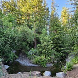
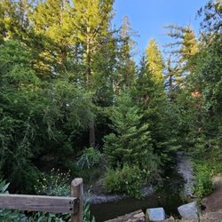
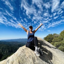
Beautiful trail down through a forest. Lots of running water. Self guided tour. Very cold and I never get cold! I saw lots of families with little kids. Parking is easy at Monte Bellon and there is a restroom. Such a nice trail! read more


The simple act of sharing a trail with people is a bit magical. There's something to be said about being out in nature, exercising the body and the mind, and being amongst other people doing the exact same thing. Call it, perhaps, the human experience. The Stevens Creek Trail is a paved multi-use trail spanning 5 miles between Shoreline Lake to the north and Heatherstone Way to the south. The trail runs parallel to Highway 85, and crosses roads and highways via a system of bridges, tunnels and underpasses. The trail also connects to parks, office complexes and neighborhoods. With so many connections, it's no wonder this trail is so popular. Heck, it even has its own website! North of Highway 101, shade on the trail is lacking. South of the highway, trees line the edges of the trail and can provide cover when the sun isn't directly overhead. Water is available only at a couple locations, like this resting area at La Avenida Street: http://www.yelp.com/biz_photos/stevens-creek-trail-mountain-view?select=IyA0vz2HCrc_HSGaPoxttg#IyA0vz2HCrc_HSGaPoxttg And not to mention, the cities of Mountain View, Sunnyvale, Cupertino and Los Altos are cooperating to come up with plans to extend the trail south, with the ultimate goal being to reach the Santa Cruz Mountains! Now that would be awesome! Are they making progress? Well over the last few years, I've seen two new bridges constructed (like this one to Heatherstone Way: http://www.yelp.com/biz_photos/stevens-creek-trail-mountain-view?select=vTIXP4zl7vqW1ZfH-WVrZw#vTIXP4zl7vqW1ZfH-WVrZw) and the trail extended half a mile to the south, so I have faith! read more


 at Heatherstone Way - Hiking Near Me")
So enjoyed this trail during my 4 day stay in the area. My pup and I walked it everyday. The attention to detail is evident. Clean trails, well placed benches, parks, doggie stations and trash cans. The informational signs, all along the trail, were excellent. Such a wonderful preserve area for plant and wildlife. People whether walking, running or biking were all quite considerate. Don't miss this trail! read more


This is my favorite trail to go running on. It's a multi-use trail that has a lot of flexibility in terms of how far you want to run. I love that there are no cars so it provides a great alternative to getting around as well. It is connected to where I work, so it is such an easy option for me. It's a very safe trail to run on as well. Dogs are allowed on the trail too for certain parts of it. :) read more

I live very close by to the trail, so at least once a week, I'd run a 5K or go on a bike ride using the trail to get to Shoreline Park, Shoreline Amphitheater and the Duck Pond. In the Summer time, there are a lot of gnats flying in the sun. Sometimes near the gough when the Steven Creek trail meets the Bay trail, the water there sinks like the steward system. When the sun is about to set, sometimes all these wild birds come out like falcons and owls, I even once saw a raccoon as I was walking home from Beyond Wonderland and there are a cute duck family, but be careful, even though they're cute, they'll chase after you if you get too close to them. I'd recommend this trail to friends and family, the sight of when you're doing activities such as jogging and running is worth the experience. Oh yeah, please don't go jogging or walking on the trail by yourself along at night because I've done it and I can say it's scary, when I hear something fiddling near a bush or when I come across a bush, I'm afraid someone may jump out! read more

5 years ago
Straight trail that's perfect for running on flat surfaces. It's decently cool and there's usually a few other joggers to keep you moving and motivated. Also close to a shopping center with a coffee shop to meet your friends at beforehand. read more


6 years ago
8 years ago
I've always been curious about this trail and I'm glad Yelp led me here today! I was able to find lot of street parking at the Heatherstone & Dale Trail entrance . Once you cross over the 85 freeway overpass, the trail is very nice and scenic. The garden on the left ( as you are going Northbound) was very cool. I was running today with my son in his stroller. The slight elevation changes with the overpasses made for challenging conditions. There is a good amount of variety on this trail which is great for training for racing. Overall, I had a great experience on the Stevens Creek Trail and look forward to going back soon! read more


9 years ago
This ~5 mile trail in Mountain View is absolutely beautiful. I honestly wish more cities would have a trail like this in their neighborhood to boost a healthy lifestyle in it's community as well as having an easy way for residents to get to work and enjoy the scenery. There is a creek and many trees+bridges along the trail. You will see many bikers or people running on this trail so be aware of people passing behind you on your left side! Make sure that if you're walking or running to stay in the far right so bikers can easily pass you and not hit another biker that's coming towards you. What I love about this trail is that the city maintains it so well. There is often someone working to blow the leaves away from the trail, cleaning up the creek and or removing of trees. One great example was that I was running along the trail at 7am and a tree was on the trail blocking both ways. Workers came right away to remove is and within an hour, it was almost all gone. I highly recommend this trail for anyone who lives or works around this area. read more
 - Hiking Near Me")


My favorite trail for good conversations and singing lessons. This 5-mile path spanning roads and freeways is well-paved and relatively flat, so it's perfect for holding a conversation with someone whose company you enjoy, while also getting some calorie burn! Although the path is usually traversed by many bikers, runners, and walkers, one is still able to maintain a mood of serenity and privacy. Passersby are typically friendly if you are feeling social, and there is high potential for seeing cute puppies! It runs alongside the Stevens Creek, which can be flowing or extremely shallow, depending on the rainfall. The creek houses various birds, and during your journey you'll probably see at least five pairs of ducks. They are usually in male-female pairs, but on a few occasions I've seen some "boys' outdoor time" or "ladies' night" gatherings. You may even see some beautiful egrets. If you walk from the trailhead at Central Ave to the very end, you will witness the following: * A few short pathways through tunnels or under overpasses that tend to be loud * Bridge connecting the trail over streets * Wildlife Corridor which has some gorgeous trees * Rest stop and water fountain at La Avenida Trailhead * Foxtail Lane - My nickname for the area after La Avenida Trailhead. Multitudes of foxtails dot the landscape on either side of the trail. In spring the grasses are lush and green. In summer, Foxtail Lane is reminiscent of a glowing golden field. Breathtakingly beautiful! * A beautiful nursery with tons of trees * Trailer park * Google I've walked the entire trail at various times of day, even in the evening to view fireworks on the hills overlooking Shoreline Ampitheatre. It gets rather dark at night, so bring a flashlight... unless you are going for the ultimate nature experience, in which case it can be exciting. Maybe I'll see you here. Or maybe you'll hear me (and one of my voice students) approaching from miles away. DATE TIP: This is a great venue for getting to know someone. But you may want to make sure beforehand that your date enjoys an active outdoorsy setting. read more


Pros: -A lovely way to traverse Mountain View via bike or foot (it's about 5 miles long in Mountain View). -Not usually crowded; a great way to escape car traffic. -Lovely trees and creeks along with several pedestrian bridges; you can even go off the trail to learn about native plant species (this is by the newer mountain view portion of Dale/Heatherstone road). -Near one of my fav Starbucks; I like to study there then pop out on this trail for a walk. Cons: -It runs parallel to freeways and Central Expressway which leads to breathing in car exhaust. -Poorly lit at night; ladies beware. Use lights and reflective clothing. -There are some shady characters near the 101 and 85 area and when you cross the bridge by the power station. read more


SUMMARY: Easy to get to, but not super awesome as far as trails go. THE GOOD: - Paved so easy to bike through. - Very clean and well-maintained (props to Friends of Stevens Creek Trail - http://www.stevenscreektrail.org/). - The bridge over Caltrain is fun. It shakes if you jump (not to say I jumped, nope). - Not super crowded, but crowded enough that if you're walking alone, an axe-murderer would think twice before jumping you. - Long with many entrances, and Shoreline Park is a fun destination at the end. - It's so close to many parts of Mountain View, including Downtown. You have no excuse not to visit for a quick outside excursion. THE BAD: - Because much of it's paved, if you're walking, it doesn't really feel like a "trail". It's probably not good for your knees either if you're going for a run. If I'm going to walk on concrete, I'd have more fun wandering the streets of Downtown Mountain View or Palo Alto (or even the mall, heh). - Since it's parallel to Highway 85, the super loud freeway noise reminds you you're nowhere near real nature. Ditto when you see a suburban street every half mile or so. - Hearing the name, you're expecting to see a creek and hear the sound of water, but there's no water and the "creek" is more like a big ditch. - No especially neat plants or wildlife. I was pleasantly surprised to find a trail nearby and I'll undoubtedly visit again because of the proximity, but I wouldn't make a special trip. read more

6 years ago
12 years ago
7 years ago
5 years ago
14 years ago
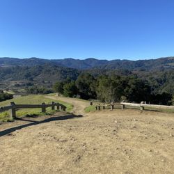
Serene and quiet, go and walk or job and breath calmness! But just don't got when they are working (construction ongoing near the NASA research center) because it kills the purpose of relaxation. I just like to observe and meditate and since it is pretty flat you can go miles and miles without noticing time flies. Apt for everybody and I like that there are so many entrance points, this way you can never get bored. read more


9 years ago
6 years ago
11 years ago
15 years ago
18 years ago
17 years ago
15 years ago
17 years ago
16 years ago
Page 1 of 3
More info about Stevens Creek Trail
Mountain View, CA 94043
Directions
Visit Website
http://www.stevenscreektrail.org/
Hours
Indoor Amenities
Outdoor Amenities
Ask the Community - Stevens Creek Trail
Review Highlights - Stevens Creek Trail
You might also consider


Why does Yelp recommend reviews?
Stevens Creek Trail - hiking - Updated July 2026
Best of Mountain View
People found Stevens Creek Trail by searching for…
Beaches in Mountain View, California
Hiking Trails in Mountain View, California
Running Trails in Mountain View, California
View Fireworks in Mountain View, California
Scenic Places to Walk in Mountain View, California
Dog Friendly Hiking Trails in Mountain View, California
Walking Trails in Mountain View, California
Sunrise View in Mountain View, California
Fall Foliage in Mountain View, California
Photo Spots in Mountain View, California
Scenic Drive in Mountain View, California
Night View in Mountain View, California
Redwood Forest in Mountain View, California
Scenic Views in Mountain View, California
Free Things to Do in Mountain View, California
Watch Sunset in Mountain View, California
Star Gazing in Mountain View, California
Stroller Friendly Hikes in Mountain View, California
Easy Hikes in Mountain View, California
Night Hike in Mountain View, California
Shaded Hike in Mountain View, California
Stargazing in Mountain View, California
Trending Searches in Mountain View, CA
Black Owned Nail Salons in Mountain View, CA
Boat Rental in Mountain View, CA
Cliff Jumping in Mountain View, CA
Day Trips in Mountain View, CA
Dog Friendly Trails in Mountain View, CA
Dog Swimming in Mountain View, CA
Jet Ski Rental in Mountain View, CA
Kayak Rental in Mountain View, CA
Lakes & Ponds in Mountain View, CA
Off Road Trails in Mountain View, CA
Outdoor Activities in Mountain View, CA
Places To Walk Around in Mountain View, CA
Pool Day Pass in Mountain View, CA
Public Pools in Mountain View, CA
Public Shower in Mountain View, CA
River Swimming in Mountain View, CA
Rock Quarry in Mountain View, CA
Scenic Night View in Mountain View, CA
Scenic Overlook in Mountain View, CA
Secluded Spots in Mountain View, CA
Soccer Store in Mountain View, CA
Splash Pad in Mountain View, CA
Strawberry Picking in Mountain View, CA
Sunrise View in Mountain View, CA
Swimming Holes in Mountain View, CA
Swimming Lakes in Mountain View, CA
Watch Sunset in Mountain View, CA
Browse Articles
Browse Nearby
BEST of Mountain View, California Coffee near Stevens Creek Trail
BEST of Mountain View, California Restaurants near Stevens Creek Trail
BEST of Mountain View, California Things to Do near Stevens Creek Trail
BEST of Mountain View, California Walking Trails near Stevens Creek Trail
BEST of Mountain View, California Parks near Stevens Creek Trail
BEST of Mountain View, California Breakfast near Stevens Creek Trail
BEST of Mountain View, California Hot Springs near Stevens Creek Trail
BEST of Mountain View, California Campgrounds near Stevens Creek Trail
BEST of Mountain View, California Sightseeing near Stevens Creek Trail
Browse Brands
Related Searches in Mountain View, CA
Affordable Kayak Rental Services in Mountain View, California
Best Fishing Locations and Guides in Mountain View, California
Best Nature Trails for Hiking in Mountain View, California
Best Places for Horseback Riding in Mountain View, California
Check Out Off Road Trails in Mountain View, California
Discover Dog Friendly Trails to Explore in Mountain View, California
Discover Kid Friendly Hiking Trails in Mountain View, California
Discover Scenic Hiking Trails in Mountain View, California
Discover Scenic Mountain Bike Trails Near Mountain View, California
Discover Scenic Waterfall Spots in Mountain View, California
Discover Walking Parks in Mountain View, California Near You
Discover a Hiking Trail in Mountain View, California
Discover the Best Night Hike Trails in Mountain View, California
Dog-Friendly Hikes With Dogs in Mountain View, California
Enjoy Camping Adventures Around Mountain View, California
Enjoy Exciting Mountain Biking Adventures in Mountain View, California
Enjoy Kayaking Adventures in Mountain View, California
Enjoy Tent Camping Spots Around Mountain View, California
Enjoy a Beautiful Waterfall Hike in Mountain View, California
Enjoy a Peaceful Nature Walk in Mountain View, California
Enjoy the Best Walking Path in Mountain View, California
Enjoy the Best Walking Trails in Mountain View, California
Exciting Cliff Jumping Spots in Mountain View, California
Experience Thrilling White Water Rafting in Mountain View, California
Explore Beautiful Parks and Green Spaces in Mountain View, California
Explore Easy Hikes Perfect for All in Mountain View, California
Explore Fun Activities to Do in Mountain View, California
Explore Popular Campgrounds Near Mountain View, California
Explore the Best Beach Spots in Mountain View, California
Explore the Best Trail Options in Mountain View, California
Family Friendly Hiking With Kids in Mountain View, California
Find Popular Ziplining Spots Around Mountain View, California
Find the Best Parks for Picnics in Mountain View, California
Find the Best Scenic View Locations in Mountain View, California
Great Places to Walk in Mountain View, California
Hike the Popular Waterfall Trail in Mountain View, California
Hiking Trails With Waterfalls in Mountain View, California
Off Leash Dog Hiking Trails in Mountain View, California
Plan a Scenic Drive Route Near Mountain View, California
Popular Outdoor Activities to Try in Mountain View, California
Popular Picnic Spots to Visit in Mountain View, California
Safe River Swimming Areas in Mountain View, California
Safe and Fun Parks for Kids in Mountain View, California
Top Climbing Spots and Gyms in Mountain View, California
Top Paddleboarding Activities in Mountain View, California
Top Running Trails to Explore in Mountain View, California
Top Swimming Lakes to Enjoy in Mountain View, California
Top Swimming Spots and Pools in Mountain View, California
Walk Dog Friendly Hiking Trails in Mountain View, California
Walk the Best Paved Walking Trails in Mountain View, California
People who viewed Stevens Creek Trail also viewed
PG&E Trail
21 reviews
Adobe Creek Loop Trail
11 reviews
Permanente Creek Trail
8 reviews
Midpeninsula Regional Open Space District
23 reviews
Coal Mine Ridge Nature Preserve
15 reviews
Saratoga Gap Open Space Preserve
18 reviews
Rancho San Antonio Preserve
778 reviews
El Corte de Madera Creek Preserve
78 reviews
San Tomas Aquino Creek Trail/Saratoga Creek Trail Reach 5
13 reviews
San Francisquito Creek
6 reviews