Adobe Creek Loop Trail Photos
 - Hiking Near Me - Palo Alto, California")


You might also consider
More like Adobe Creek Loop Trail
Recommended Reviews - Adobe Creek Loop Trail
Start your review...

Reviews With Photos - Adobe Creek Loop Trail

Been looking for local trails to go biking on and found this one which is pretty nice! It's pretty flat the whole way. When riding toward Lakeshore lake(?) it is fine but on the way back, you are riding against the wind, so it's a little more of a workout. This trail turns into the Bay View Trail I believe and offers so many more miles of biking trail along the bay. It is a gravel road mostly on the Adobe Trail. Lots of birds along the way. Weather was great! We went late March 2021. There are 2 parking lots and we got lucky and found a spot right away but I could see it getting full quick. If you are biking, it's easy to park a little further out and ride in.

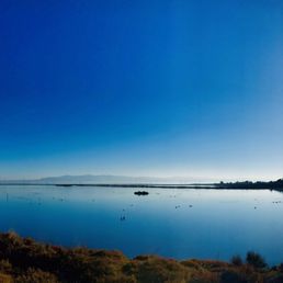
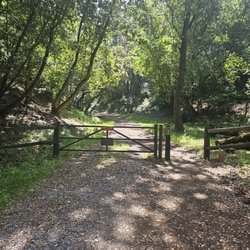
Starting at Byxbee Park in Palo Alto and ending at the Benjamin Lefkowitz underpass on US101 the trail offers decent views of the Bay and the Santa Cruz Mountains. The vast majority of the trail is packed gravel, however off on the Western Side is a unpaved trail close to the water that is fun to run in a Mountain Bike. It seems to very popular with the bird watching set and its not uncommon to see people lugging those giant National Geographic lenses that look like they could be used to image the Space Station. If biking do use some care. It is popular with families and you will see kids who can do the darnedest things when you approach them on a bike. Also, there will be a fair amount of snow geese depending on the season. Right now they just arrived and are simply feeding, but soon they will nest. Before the babies they are generally docile and get out of you way, but once the young ones come they can get aggressive. So do yourself a favor, if they are hissing at you give them wide berth. Also as with most of these trails there is really nothing other than the restrooms at either trailhead. Other than that you are on your own. Cell phone coverage is pretty good on this trail section as well. Trail: Paved and gravel Suitable For: Hiking, Mountain Bikes, and Road Bikes (in some sections only) Services: None Length: 5.5 miles
Following my friend's recommendation, I visited here for my morning run. The weather was gorgeous w/warm November sun and less wind, and the view from every spot and corner of the trail was magnificent. The trail was lightly trafficked; I was totally alone on some portions of the trail (8:30am-9:30am, Sunday morning). I recommend this place for easy jogging w/occasional breaks to admire the view and birdwatching, especially when the sun is high and warm. Enjoy!

Very flat trail, very pleasant to hike or bike, like i did. The landscape is gorgeous, so flat and you have the bay on one side, so it get breezy and has some calming effect. Watch out with rattlesnakes, I also kill one of two on my 6.5 miles of amazingness. It is also an excellent place to watch birds of different varieties as well as to observe the nice public art with metal sculptures that blend with the landscape.

1 year ago
Running along the wide gravel pathways on a Wednesday afternoon was invigorating, and the endless views of nature therapeutic. A great opportunity for birdwatching too. I encountered many species, including geese grazing in the grassy fields and adorable ducks floating in the water. To add to the beautiful and serene setting, visitors can find art in the park as well (wind wave, pole fields, and chevrons), nothing too fancy but interesting enough, especially walking among the artworks and reading about them on the information boards posted along the trail. The small parking lot near Byxbee Park was full, but I had no problem finding street parking down the road on Embarcadero. There was also a public restroom available for convenience. Certainly a great place to get your steps in while appreciating the lovely scenery. read more
 - Hiking Near Me - Palo Alto, California")

 - Hiking Near Me - Palo Alto, California")
 - Hiking Near Me - Palo Alto, California")


Beautiful spot to come on a warm day. My husband rides his bike near here and wanted to show me the area. I love all the birds here! It is a surprisingly long loop and we didn't finish the whole thing today, but we intend to return and do the rest of the loop soon...you should too! read more


1 year ago
Been looking for local trails to go biking on and found this one which is pretty nice! It's pretty flat the whole way. When riding toward Lakeshore lake(?) it is fine but on the way back, you are riding against the wind, so it's a little more of a workout. This trail turns into the Bay View Trail I believe and offers so many more miles of biking trail along the bay. It is a gravel road mostly on the Adobe Trail. Lots of birds along the way. Weather was great! We went late March 2021. There are 2 parking lots and we got lucky and found a spot right away but I could see it getting full quick. If you are biking, it's easy to park a little further out and ride in. read more


Starting at Byxbee Park in Palo Alto and ending at the Benjamin Lefkowitz underpass on US101 the trail offers decent views of the Bay and the Santa Cruz Mountains. The vast majority of the trail is packed gravel, however off on the Western Side is a unpaved trail close to the water that is fun to run in a Mountain Bike. It seems to very popular with the bird watching set and its not uncommon to see people lugging those giant National Geographic lenses that look like they could be used to image the Space Station. If biking do use some care. It is popular with families and you will see kids who can do the darnedest things when you approach them on a bike. Also, there will be a fair amount of snow geese depending on the season. Right now they just arrived and are simply feeding, but soon they will nest. Before the babies they are generally docile and get out of you way, but once the young ones come they can get aggressive. So do yourself a favor, if they are hissing at you give them wide berth. Also as with most of these trails there is really nothing other than the restrooms at either trailhead. Other than that you are on your own. Cell phone coverage is pretty good on this trail section as well. Trail: Paved and gravel Suitable For: Hiking, Mountain Bikes, and Road Bikes (in some sections only) Services: None Length: 5.5 miles read more


5 years ago
Following my friend's recommendation, I visited here for my morning run. The weather was gorgeous w/warm November sun and less wind, and the view from every spot and corner of the trail was magnificent. The trail was lightly trafficked; I was totally alone on some portions of the trail (8:30am-9:30am, Sunday morning). I recommend this place for easy jogging w/occasional breaks to admire the view and birdwatching, especially when the sun is high and warm. Enjoy! read more


 - Hiking Near Me - Palo Alto, California")
 - Hiking Near Me - Palo Alto, California")
3 years ago
Very flat trail, very pleasant to hike or bike, like i did. The landscape is gorgeous, so flat and you have the bay on one side, so it get breezy and has some calming effect. Watch out with rattlesnakes, I also kill one of two on my 6.5 miles of amazingness. It is also an excellent place to watch birds of different varieties as well as to observe the nice public art with metal sculptures that blend with the landscape. read more


For a great nature walk, try the Palo Alto Baylands Adobe Creek Trail. The trail is a nice solid ~6.5 mile walk, relatively flat trail. After it had rained, wasn't too muddy. Took me 90 min to walk. Restrooms at start of trail near Terminal street where you park your car. A trail for birdwatching and meditation. Also, like the benches along the way to soak in views. The only part I didn't like is the par of the trail that runs along the street/101 freeway. Otherwise, very enjoyable for exercise. People walk, birdwatching, run, or even bike. read more

More info about Adobe Creek Loop Trail
Embarcadero Wy
Palo Alto, CA 94303
Directions
(650) 617-3156
Call Now
Hours
Outdoor Amenities
From the Business
Ask the Community - Adobe Creek Loop Trail
Review Highlights - Adobe Creek Loop Trail
You might also consider


Adobe Creek Loop Trail - hiking - Updated July 2026
Best of Palo Alto
People found Adobe Creek Loop Trail by searching for…
Parks in Palo Alto, California
Hiking Trails in Palo Alto, California
Walking Trails in Palo Alto, California
Scenic Places to Walk in Palo Alto, California
Scenic Views in Palo Alto, California
Easy Hikes in Palo Alto, California
Shaded Hike in Palo Alto, California
Beautiful Views in Palo Alto, California
National Parks in Palo Alto, California
Hiking With Kids in Palo Alto, California
Free Parking in Palo Alto, California
Lakes & Ponds in Palo Alto, California
Trail in Palo Alto, California
Running Trails in Palo Alto, California
Photo Spots in Palo Alto, California
Off Road Trails in Palo Alto, California
Wildflowers in Palo Alto, California
Hiking Trails Kid Friendly in Palo Alto, California
Sunset Views in Palo Alto, California
Scenic Overlook in Palo Alto, California
View Points in Palo Alto, California
Nature Walks in Palo Alto, California
Trending Searches in Palo Alto, CA
Black Owned Nail Salons in Palo Alto, CA
Cliff Jumping in Palo Alto, CA
Dog Friendly Trails in Palo Alto, CA
Jet Ski Rental in Palo Alto, CA
Lakes & Ponds in Palo Alto, CA
Off Road Trails in Palo Alto, CA
Outdoor Activities in Palo Alto, CA
Places To Walk Around in Palo Alto, CA
Pool Day Pass in Palo Alto, CA
Public Shower in Palo Alto, CA
River Swimming in Palo Alto, CA
Scenic Night View in Palo Alto, CA
Scenic Overlook in Palo Alto, CA
Secluded Spots in Palo Alto, CA
Strawberry Picking in Palo Alto, CA
Swimming Holes in Palo Alto, CA
Browse Articles
Browse Nearby
BEST of Palo Alto, California Coffee near Adobe Creek Loop Trail
BEST of Palo Alto, California Things to Do near Adobe Creek Loop Trail
BEST of Palo Alto, California Restaurants near Adobe Creek Loop Trail
BEST of Palo Alto, California Walking Trails near Adobe Creek Loop Trail
BEST of Palo Alto, California Parks near Adobe Creek Loop Trail
BEST of Palo Alto, California Breakfast near Adobe Creek Loop Trail
BEST of Palo Alto, California Campgrounds near Adobe Creek Loop Trail
Browse Brands
Related Searches in Palo Alto, CA
Affordable Kayak Rental Services in Palo Alto, California
Best Fishing Locations and Guides in Palo Alto, California
Best Nature Trails for Hiking in Palo Alto, California
Best Places for Horseback Riding in Palo Alto, California
Best Waterfalls and Swimming Holes in Palo Alto, California
Check Out Off Road Trails in Palo Alto, California
Discover Dog Friendly Trails to Explore in Palo Alto, California
Discover Kid Friendly Hiking Trails in Palo Alto, California
Discover Scenic Hiking Trails in Palo Alto, California
Discover Scenic Mountain Bike Trails Near Palo Alto, California
Discover Scenic Waterfall Spots in Palo Alto, California
Discover Walking Parks in Palo Alto, California Near You
Discover a Hiking Trail in Palo Alto, California
Discover the Best Night Hike Trails in Palo Alto, California
Discover the Best Running Track in Palo Alto, California
Dog-Friendly Hikes With Dogs in Palo Alto, California
Enjoy Camping Adventures Around Palo Alto, California
Enjoy Kayaking Adventures in Palo Alto, California
Enjoy Tent Camping Spots Around Palo Alto, California
Enjoy a Beautiful Waterfall Hike in Palo Alto, California
Enjoy a Peaceful Nature Walk in Palo Alto, California
Enjoy the Best Walking Path in Palo Alto, California
Enjoy the Best Walking Trails in Palo Alto, California
Experience Thrilling White Water Rafting in Palo Alto, California
Explore Beautiful Parks and Green Spaces in Palo Alto, California
Explore Easy Hikes Perfect for All in Palo Alto, California
Explore Fun Activities to Do in Palo Alto, California
Explore Popular Campgrounds Near Palo Alto, California
Explore the Best Beach Spots in Palo Alto, California
Explore the Best Trail Options in Palo Alto, California
Family Friendly Hiking With Kids in Palo Alto, California
Find Beautiful Views in Palo Alto, California
Find the Best Parks for Picnics in Palo Alto, California
Find the Best Scenic View Locations in Palo Alto, California
Great Places to Walk in Palo Alto, California
Hike the Popular Waterfall Trail in Palo Alto, California
Hiking Trails With Waterfalls in Palo Alto, California
Off Leash Dog Hiking Trails in Palo Alto, California
Plan a Scenic Drive Route Near Palo Alto, California
Popular Outdoor Activities to Try in Palo Alto, California
Popular Picnic Spots to Visit in Palo Alto, California
Safe River Swimming Areas in Palo Alto, California
Safe and Fun Parks for Kids in Palo Alto, California
Top Climbing Spots and Gyms in Palo Alto, California
Top Paddleboarding Activities in Palo Alto, California
Top Running Trails to Explore in Palo Alto, California
Top Swimming Lakes to Enjoy in Palo Alto, California
Top Swimming Spots and Pools in Palo Alto, California
People who viewed Adobe Creek Loop Trail also viewed
Stevens Creek Trail
94 reviews
Byxbee Park
35 reviews
The Dish - Stanford Foothills
522 reviews
Woodside Trails
4 reviews
Moffett Bay Trail
5 reviews
Bair Island Wildlife Refuge & Trail
2 reviews
Foothill Fitness Trail
2 reviews
Mora Trail
7 reviews
Monte Bello Open Space Preserve
56 reviews
Crystal Springs Regional Trail
54 reviews