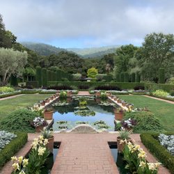
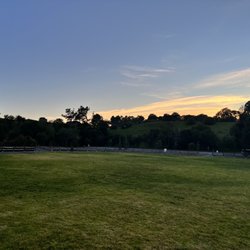
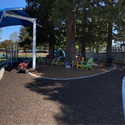
Wunderlich Park Photos


You might also consider
More like Wunderlich Park
Recommended Reviews - Wunderlich Park
Start your review...

Reviews With Photos
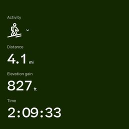
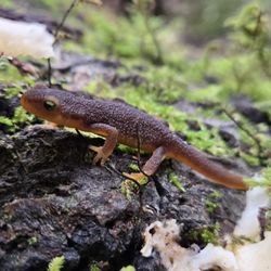
Came here on a Sunday morning around 10:45AM. There is a lot where you can park, but it was mostly full so consider going earlier if you're worried. There is a horse stable right by the lot, so you can see the beautiful horses and even take lessons! However, this also means you will be running into horse poop a lot on the trails. We were very confused at first on where to start the trail -- we walked up the large hill that was a large inclination. Don't do this!! Follow the wooden signs with arrows. Once we found the correct starting point, we were on our way on the Bear-Gulch and Alambique Trail (the highest rated one on AllTrails). The trail was very muddy and shaded with trees, and we passed by several families hiking. We came across a bench for resting and some beautiful redwood trees. The trail was supposed to be 4.6 miles and an estimated 2hrs and 20 minutes. However, the signs along the trail were pretty confusing, so we ended up walking off trail. Not to complain though, as we walked past this green pond which supposedly had keels (red belly lizards) in it. We ended up doing 4.1 miles for 2hrs and 7 minutes, although we were confused at first where the parking lot was. Overall, this hike is good if you want to get some steps in and look at trees, but maybe not the best hike for uphill climbing with a view at the end. I'd recommend heading to Alice's Restaurant nearby for food before or after!


Yay! We wanted to go on a hike and found out the park was open today! There were some trails that were closed due to the storms, but we were able to get a 3 mile hike done. The parking lot is small, FYI. They have picnic tables and restrooms right by the parking lot. There is also a stable and museum at the park as well!

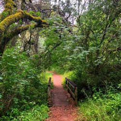
What a wonderful trail to get lost among California redwoods! Highly recommend for those who want to soak up some nature and get a good workout at the same time. The Hike: Once you are parked, you can start your trek up the hill. The trail I took was the Alambique trail up to skyline. 4.5 miles up, mostly uphill, this was a calorie burner! Definitely recommend bringing water and taking breaks when needed. You'll be treated to some views of the peninsula, but it's mostly getting lost within the redwoods. Be careful when coming back down, and follow trailhead signs. I missed a turn and ended up adding an additional 2 miles to my hike, bringing it to a total of 11. Round trip took around 2+ hours, depending on your pace. There's also horses on the trail, so watch out for their droppings! The higher you go on the trail, the less there is. The parking situation: The parking lot here is really small, maybe 20-25 cars max? The earlier you get here the better your chances of grabbing a parking spot. The parking lot is tight, and ppl are itching to find the next open spot. If you are coming with a group, carpool if possible because there's no other parking options nearby. Mid mornings are super busy, parking becomes easier later in the afternoon. Restrooms: the only restrooms are at the trail parking lot. Highly recommend checking out for its accessibility and proximity to 280, great exercise potential, and the perfect workout for me to earn my weekly cheat meal!

Minus one star for minefield of horse poop everywhere. Yes I understand there are horses that walk the trails and yes I understand horses poop A LOT! But when every 20 steps you take involves trying to avoid getting shit on your shoes... well, that kinda takes away from being able to enjoy your hike... I do love some of the trails here -- covered in lush trees and shading with a good elevation climb but not so tough that you can't walk down stairs the next day. Parking can definitely be tough on the weekends with the limited spaces and there is no nearby parking outside of the park. That would be one reason to deter me from coming back. Bathrooms are also pretty gross -- non flushable step above porta-potty type.

Wunderlich Park is one of my favorite places in Woodside. It has 7 trails: Redwood trail, Madrone trail, Loop trail, Meadow trail, Bear Gulch trail, Alambique trail, and Skyline trail. My favorite trail is Alambique trail. It's 4.5 miles one way so it makes an amazing 9 mile trail if you go up and back. It goes from the parking lot all the way to Skyline Road. it's almost completely covered so it's a strenuous but cool temperature hike. There is also covered hike that takes you to a place called Salamander Flats but honestly, Salamander Flats is really kinda gross. It's basically a giant pool of algae water. Meadow Trail is a great trail to take if you want to hike to a look out area. Sadly no pets are allowed in this park except horses. There are horse stables at Wunderlich. Overall it's a really nice park that offers covered hikes and cool temperatures all year.

great for horse riders...parking can be difficult, but free...definitely more for equestrian enthusiasts...the park is shady with hiking trails, but littered with horse manure...mostly hay that have passed through the digestive track, so not as bad...helmets and horse rides available at the stable...$15 for pony ride..$45 for 30 minute horse ride and $70 for 60 minutes...

Hiking through the forest. Gonna have lots of fun! Wunderlich is a quiet shaded park in Woodside. There is always plenty of free parking, either in their lot or along the street. The trails are studded with gorgeous redwoods and fragrant eucalyptus trees. I suggest always wearing a wide brim hat outdoors, but this is one park where you might feel ok going without a hat. The trials are all well marked and there are trail maps located near the carriage house. This park is also a horse riding trail so watch out for the horse manure. Learning horse/human interaction might be useful here. Someone once left a funny sign saying "Beware of trophy wives on their high horses". Cute. However, the women they speak of might simply have been asking people to stand still by the side of the trail as the horses passed. This reduces the chances of frightening a horse. Why not be courteous and potentially kind to an animal? Also, it's presumptuous to assume these women are simply "trophies". While there are people who get by simply on their looks, there are also highly accomplished women who are also beautiful. Maybe the real trophies they referred to were beautiful, smart, accomplished and also animal lovers. Wunderlich closes at sunset but is a real treat to run at dusk. There's nothing more exhilarating than being on an empty trail just as the sun has set.

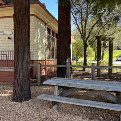
Oh the wonders of Wunderlich Park. It is a bit hidden in the wilds of Woodside and its showpiece is the Folger Stable, which is on the National Register of Historic Places. But for us, it is all about family. It was my father-in-law's favorite place to run, so it is an opportunity for us to go on a hike, remember him fondly and it allows my boys to ask questions about their grandfather who passed away before they were born. The park is 942 acres and filled with hiking and equestrian trails. Our destination is always Redwood Flat which we reach by taking the Bear Gulch Trail up, up, up to see the mighty redwood trees. I have such a fondness for California, but forget that many of the state's parks are filled with poison oak and ticks. Such a buzzkill to tell your kids, "Don't touch anything!" The trails were a bit overgrown although otherwise well maintained for a pleasant hike. The wildflowers were beautiful this time a year and we didn't see too many other hikers so it certainly didn't feel crowded although parking is a challenge since the lot is very small. Also, the only facilities are located at the trailhead and you really don't want to wander off trail here.

EXPERIENCE I recently visited Wunderlich Park to visit their museum and carriage house. I didn't go for an extensive hike but want to return someday to do so! STARS (stand out qualities) -Beautiful and well maintained park -Well preserved historical site STAIRS (areas of growth) -More signage clarifying which of two entrances to enter at TIPS -Parking is limited so good to carpool or come during weekday if you can -Try signing up for tour. I learned interesting history of Chinese laborers! read more


Small Wunder A 940-acre park nestled in the eastern Redwoods and madrone-laden slopes of King Mountain. The name of the park is derived from contractor Martin Wunderlich, who donated the land to San Mateo County. The Good: * Free to visit * Parking lot * Picnic tables available * Restroom in parking lot * Seventeen miles of trails, including several loops. * If you like horses, then this is the place for you! There's a really cool old historic stable and lots of equine action to be found. * Camping available (https://www.smcgov.org/parks/make-reservation) The Meh: * Currently, no recreational horse activities like trail rides and lessons are available. * Crazy elevation gains, as trail elevations run from ±350' to over 4,300'. Be sure to check the trail guides to make sure you don't get in over your head. * No dogs allowed The Ugly: * The restroom has no running water, just hand sanitizer. * I'll admit, I'm not a fan of horses, and having to share trails with horses isn't my idea of a good time. Conclusion: Not the biggest park in this area that's full of fantastic OSPs, but it's certainly worth a visit--especially if you're a hippophile. read more


Hiked at Wunderlich Park on a sunny Saturday in March! We used AllTrails for directions and we reached around 9am - to our surprise, the parking lot was full by then so definitely recommend coming earlier. There were multiple cars circling around looking for a spot as well. We ended up waiting about 30 minutes before parking. We did the Bear Gulch and Alambique trail clockwise. There are some brief steep sections, but for the most part, the trail was moderate in terms of difficulty. We didn't encounter too many people despite all the cars in the lot. We spotted a small snake on the trail and there was a lot of horse manure on the Alambique portions, so we had to watch our step closely. The trail was mostly shaded which was nice, but there wasn't much of a view. Overall, the trail was well marked and maintained (minus the manure on Alambique). Good hike for a sunny day, but the parking lot situation could be improved. read more


Came here on a Sunday morning around 10:45AM. There is a lot where you can park, but it was mostly full so consider going earlier if you're worried. There is a horse stable right by the lot, so you can see the beautiful horses and even take lessons! However, this also means you will be running into horse poop a lot on the trails. We were very confused at first on where to start the trail -- we walked up the large hill that was a large inclination. Don't do this!! Follow the wooden signs with arrows. Once we found the correct starting point, we were on our way on the Bear-Gulch and Alambique Trail (the highest rated one on AllTrails). The trail was very muddy and shaded with trees, and we passed by several families hiking. We came across a bench for resting and some beautiful redwood trees. The trail was supposed to be 4.6 miles and an estimated 2hrs and 20 minutes. However, the signs along the trail were pretty confusing, so we ended up walking off trail. Not to complain though, as we walked past this green pond which supposedly had keels (red belly lizards) in it. We ended up doing 4.1 miles for 2hrs and 7 minutes, although we were confused at first where the parking lot was. Overall, this hike is good if you want to get some steps in and look at trees, but maybe not the best hike for uphill climbing with a view at the end. I'd recommend heading to Alice's Restaurant nearby for food before or after! read more


3 years ago
Yay! We wanted to go on a hike and found out the park was open today! There were some trails that were closed due to the storms, but we were able to get a 3 mile hike done. The parking lot is small, FYI. They have picnic tables and restrooms right by the parking lot. There is also a stable and museum at the park as well! read more


What a wonderful trail to get lost among California redwoods! Highly recommend for those who want to soak up some nature and get a good workout at the same time. The Hike: Once you are parked, you can start your trek up the hill. The trail I took was the Alambique trail up to skyline. 4.5 miles up, mostly uphill, this was a calorie burner! Definitely recommend bringing water and taking breaks when needed. You'll be treated to some views of the peninsula, but it's mostly getting lost within the redwoods. Be careful when coming back down, and follow trailhead signs. I missed a turn and ended up adding an additional 2 miles to my hike, bringing it to a total of 11. Round trip took around 2+ hours, depending on your pace. There's also horses on the trail, so watch out for their droppings! The higher you go on the trail, the less there is. The parking situation: The parking lot here is really small, maybe 20-25 cars max? The earlier you get here the better your chances of grabbing a parking spot. The parking lot is tight, and ppl are itching to find the next open spot. If you are coming with a group, carpool if possible because there's no other parking options nearby. Mid mornings are super busy, parking becomes easier later in the afternoon. Restrooms: the only restrooms are at the trail parking lot. Highly recommend checking out for its accessibility and proximity to 280, great exercise potential, and the perfect workout for me to earn my weekly cheat meal! read more


6 years ago
Minus one star for minefield of horse poop everywhere. Yes I understand there are horses that walk the trails and yes I understand horses poop A LOT! But when every 20 steps you take involves trying to avoid getting shit on your shoes... well, that kinda takes away from being able to enjoy your hike... I do love some of the trails here -- covered in lush trees and shading with a good elevation climb but not so tough that you can't walk down stairs the next day. Parking can definitely be tough on the weekends with the limited spaces and there is no nearby parking outside of the park. That would be one reason to deter me from coming back. Bathrooms are also pretty gross -- non flushable step above porta-potty type. read more


4 years ago
Wunderlich Park is one of my favorite places in Woodside. It has 7 trails: Redwood trail, Madrone trail, Loop trail, Meadow trail, Bear Gulch trail, Alambique trail, and Skyline trail. My favorite trail is Alambique trail. It's 4.5 miles one way so it makes an amazing 9 mile trail if you go up and back. It goes from the parking lot all the way to Skyline Road. it's almost completely covered so it's a strenuous but cool temperature hike. There is also covered hike that takes you to a place called Salamander Flats but honestly, Salamander Flats is really kinda gross. It's basically a giant pool of algae water. Meadow Trail is a great trail to take if you want to hike to a look out area. Sadly no pets are allowed in this park except horses. There are horse stables at Wunderlich. Overall it's a really nice park that offers covered hikes and cool temperatures all year. read more

2 years ago
2 years ago
2 years ago
2 years ago
3 years ago
great for horse riders...parking can be difficult, but free...definitely more for equestrian enthusiasts...the park is shady with hiking trails, but littered with horse manure...mostly hay that have passed through the digestive track, so not as bad...helmets and horse rides available at the stable...$15 for pony ride..$45 for 30 minute horse ride and $70 for 60 minutes... read more

Hiking through the forest. Gonna have lots of fun! Wunderlich is a quiet shaded park in Woodside. There is always plenty of free parking, either in their lot or along the street. The trails are studded with gorgeous redwoods and fragrant eucalyptus trees. I suggest always wearing a wide brim hat outdoors, but this is one park where you might feel ok going without a hat. The trials are all well marked and there are trail maps located near the carriage house. This park is also a horse riding trail so watch out for the horse manure. Learning horse/human interaction might be useful here. Someone once left a funny sign saying "Beware of trophy wives on their high horses". Cute. However, the women they speak of might simply have been asking people to stand still by the side of the trail as the horses passed. This reduces the chances of frightening a horse. Why not be courteous and potentially kind to an animal? Also, it's presumptuous to assume these women are simply "trophies". While there are people who get by simply on their looks, there are also highly accomplished women who are also beautiful. Maybe the real trophies they referred to were beautiful, smart, accomplished and also animal lovers. Wunderlich closes at sunset but is a real treat to run at dusk. There's nothing more exhilarating than being on an empty trail just as the sun has set. read more

Oh the wonders of Wunderlich Park. It is a bit hidden in the wilds of Woodside and its showpiece is the Folger Stable, which is on the National Register of Historic Places. But for us, it is all about family. It was my father-in-law's favorite place to run, so it is an opportunity for us to go on a hike, remember him fondly and it allows my boys to ask questions about their grandfather who passed away before they were born. The park is 942 acres and filled with hiking and equestrian trails. Our destination is always Redwood Flat which we reach by taking the Bear Gulch Trail up, up, up to see the mighty redwood trees. I have such a fondness for California, but forget that many of the state's parks are filled with poison oak and ticks. Such a buzzkill to tell your kids, "Don't touch anything!" The trails were a bit overgrown although otherwise well maintained for a pleasant hike. The wildflowers were beautiful this time a year and we didn't see too many other hikers so it certainly didn't feel crowded although parking is a challenge since the lot is very small. Also, the only facilities are located at the trailhead and you really don't want to wander off trail here. read more


A great location, not far from Menlo Park & Palo Alto. Easy to navigate to & find with GPS. Open bathrooms available, even during COVID-19. Small parking lot, unfortunately--prepare to wait a while unless arriving early. Many beautiful horses scattered about to observe, even if you don't sign up to ride. The trail is uphill--pretty challenging to hike as a pregnant lady But there are many places to stop and rest (a bench, large boulders, flat tree stumps, etc.). The trail was also pretty muddy today, despite laying hay as an attempt to dry it up. read more


8 years ago
This place is gorgeous. I found it on yelp while in town looking for redwoods. We got there around 9 per the recommendations on here and I'm glad I did so we could get parking. There are multiple trails here and I asked a family hiking which trail and they pointed me in the right direction. It was gorgeous. There were quite a few people hiking and running. There is info at the parking lot. You can get maps of the area but they were a little confusing. At least the trails were marked pretty well as far as I went. If I am back in the are I will definitely be back. read more


I did two hikes here: Alambique trail to The Meadows then the Bear Gulch trail to the Redwood trail to Salamander Flat, then to the bottom on the Madrone trail; the second time was from Skyline Road on the Skyline trail down to the Crossroads then back up on the Alambique trail to the top. The first hike was my usual route. I love the bottom section through the redwoods. The top area is mostly eucalyptus and manzanita along with some laurel trees (kinda blah). I love The Meadows on a sunny day (which I had) as a nice place to stop, snack, and just enjoy the views down onto the bay. Heading back down you'll run into redwoods again just before Redwood Flat and down to Salamander Flat. I didn't see any salamanders in the algae-covered pond . The rest of the trail is bland switchbacks to the parking lot. The second hike was my first time starting at the top and going down first. I liked the trails although they seemed a bit steeper than my other route (I think both had about 800 feet elevation change). My start at the top of Skyline was foggy and misty. As I hit the trail it was as though it were raining with all the dew dropping from the trees! That cleared about ¼ mile into the hike and the sun came out. Of course I saw many banana slugs. I would definitely do this hike again. read more


If you're a fan of the outdoors, the San Francisco Bay Area Peninsula is truly where everything's at. From down near Los Gatos to the top of Pacifica, there's hundreds of miles of trails for all types of wilderness explorers. I can list off at least 6-7 major county parks along the Peninsula, all of which are GOLDEN GEMS. The most recent one I visited was Wunderlich Park in Woodside. Wunderlich Park is located on Woodside Road, about 10-15 minutes west from Highway 280. The really nice perks about this spot besides the fact that it's SO CLOSE TO THE FREEWAY (unlike many other parks) are that 1. It's nearby many major streets that can lead to the freeway (e.g. Skyline Blvd, Woodside Road of course, and Sandhill Road), and so transportation here is very accessible; and 2. Wunderlich is wedged between several other big parks such as Huddart and Windy Hill Open Space Preserve, making this place double as an awesome opportunity to go park hopping! Luckily, parking is free here but I recommend coming EARLY (like before noon) because the lot is small and this place gets HELLA traffic. When my girlfriend and I recently came around 9am on a Saturday, we literally took the last spot. For adventure enthusiasts who just want a more laid-back escape, Wunderlich Park is for you! Compared to other county parks in the Peninsula, this one is quite small. Virtually all the trails are 5 miles or fewer (http://parks.smcgov.org/wunderlich-park-trails). They're also mostly flat, which is perfect if you just want a more relaxing hike. So technically, you can cover the entire park in a day. If you're worried about needing to douse yourself in sunscreen, have no fear because I believe at least 90% of all the trails are underneath shade. My girlfriend and I ended up having a blast at Wunderlich. Here's some highlights: -ALAMBIQUE TRAIL: As the longest trail (5 miles to the end), Alambique offers such an exquisite experience for travelers. A majority of the trail takes you through dense forests filled with MASSIVE REDWOODS. According to the park's website, the tallest redwood in the park can be found on this trail! I just love how, even though you are walking through trees and brush, the scenery changes so dramatically as you make your way around. Really take the time to enjoy the dynamic surroundings. And don't forget to check out some of the vista points! -MEADOWS: If you get bored of the Alambique trail, I HIGHLY recommend making a right onto the Meadow Trail about 2 miles in. Essentially, this route takes you through GORGEOUS grasslands. It's totally awesome to find yourself in such an open field after spending an hour or so inside a forest. Now that's the Meadows for you! The scenery up here seems like it's straight out of a fairytale; you can literally get a bird's eye view of the entire Bay. Plus, there's a bench to sit at. -HORSIES: I'VE NEVER SEEN SO MANY HORSES IN MY LIFE. Whenever I go hiking, I never see more than 2-3 hours; I'm always bewildered at how there can be so much poop, but so few horses. However, it's an entirely different story at Wunderlich. During the 3 hours we were here, we saw 9-10 horses AT LEAST. If you are a huge fan of horses, this is the place for you. I think the reason why there's so many is that Bay Area Equestrian Connection's located here. Basically, there's stables at Wunderlich from which you can pay to go horseback riding. That's so cool! Instead of hiking through the park's many trails, you can go full-on relaxed mode and ride a horse around. OMG. Wunderlich Park is one of those public spaces where you don't have to exert too much effort to have an awesome adventure. There's plenty of trails to keep you busy, but none of which are difficult or boring. Next time, I will definitely see if I can go horseback riding or if I can tackle the entire park. Because of how relaxing and chill this place is, I give Wunderlich an "Omg, I'd travel 2 hours for this" rating. Have fun and prosper, read more


4 years ago
5 years ago
7 years ago
9 years ago
Wunderlich offers a rare combination for a peninsula hiking spot: It is very easy to get to, and it offers some long loop hike options, up to 12 miles if you have the inclination. The main entrance is only a few miles west of downtown Woodside, on La Honda Rd., (about 10 minutes from Hwy 280). Facilities are minimal: one drinking fountain plus a unisex bathroom. Parking is ample. Unlike other parks, there is also a large, private horse stable at the entrance. Not surprisingly, there is plenty of evidence of horse passage along the trails...so watch your step. Wunderlich is also one of the darkest and shadiest hiking spots I know of, making it a pretty good choice for summer months, but not so ideal for dark, rainy winter days. Views of the valley below are minimal. The canyons within the park tend to be deep and heavily-forested with Redwoods. If you go late in the day, be careful of the fast-fading light. My biggest complaint about Wunderlich is the giant grove of Eucalyptus trees in the center of the park; I can't stand the damn things (and I'm a tree-lover). In California they are no better than weeds - not only are they ugly IMHO, but they make a mess with their heavy branch and bark litter. They also out-complete and choke out all the native species. I'm not sure why the county park department lets these trees grow unabated, since they will eventually take over the entire lower half of the park, given time. All hikes I do at Wunderlich attempt to skirt this grove as much as possible. Loop 1: (~5.5 mi) from the lower parking lot at the main entrance, take Bear Gulch trail uphill along the northern edge of the park to the wide-open "Meadows" area and continue until it connects with the Oak trail; Return via the Oak Trail, where it then connects with the Meadow Trail and a short feeder back to the Bear Gulch Trail; Return the last mile the way you came. Loop 2: (5.4 mi) On Skyline Road, park off the wider margin just north of the intersection of Bear Gulch Rd (east leg). Walk to the trailhead, and take either the Alambique Trail or the Skyline Trail down to "the crossroads" and return by the other trail. Ten minutes after you reach your car, you can be at Alice's restaurant for a burger and a beer. (If only all my hikes could end that way!) Hiking Spot Checklist: (updated April 2017) -- Parking: Large lot at main entrance; otherwise roadside parking -- Bathrooms: Two unisex pit toilets next to parking -- Potable water: Yes -- Maps provided: Yes -- Highlights: Easy to get to; afternoon shady hiking in redwoods My Peninsula Hike Collection is here: (https://www.yelp.com/collection/qBI6U6Lz9LJQjnGjFW6ubg) read more

8 years ago
Not dog friendly - no dogs allowed! (See picture.) Note that i found this place by searching for "dog friendly hike". read more

5 years ago
Wunderlich Park is a great spot for a summer hike since the trails are mostly cool and shaded. There are a number of trails for you to pick and choose, ranging from moderate to strenuous. Arrive early! We arrived on a Saturday at 9am & luckily secured the last parking spot in the small lot. Before you leave the parking lot, make use of the port-a-potty (no other ones on the trail) & grab a map. We mixed and matched a number of trails for a moderate hike (4.6 miles roundtrip; ~2hrs) 1) Alambique Trail continue to Alambique Flat (2.1 miles) 2) Bear Trail (0.3 miles) 3) Meadow Trail (1.5 miles) 4) Alambique trail (0.7 miles) Surprisingly even with the parking lot full, we rarely ran into other hikers in the 2hrs we were hiking. It almost feels like you have the whole park to yourself! Post-hike, reward yourself with a tasty burger & root beer (or beer) at Alice's Restaurant just 10 minutes away! read more


Went there last weekend to hike. It was a busy day with our group of 20+ hikers and a lot more other hikers due to a gorgeous sunny day. Also there were pony rides activities going on at the stable at the trail head with lots of families with their little kids riding the ponies. I got a parking ticket for $38 for parking at the unmarked area inside the parking lot right next to the stable, even though my fellow hikers assured me it would be o.k. as it was a busy day!!! Oh well next time trust your instinct rather than what others tell you... read more

Wunderlich Park was a pleasant surprise. I did a hike on the opposite side of Skyline (Purisima Creek Trail), and it was actually incredibly strenuous because we started going downhill and ended the three hour hike with an hour-long - and very steep - uphill climb, haha. Wunderlich has a variety of trails you can do, and they're all fairly easy to follow. We did what was probably the shortest loop -- roughly 3mi. -- and were successful until the end; we ended up having to walk along Woodside Road for the last quarter mile or so. Woops! I'm not sure where we veered off, but we definitely went down a trail path. It just happened to lead down through a neighborhood and onto the main road. If you start going through houses, turn around and try to connect onto the trail again. There are longer trails as well, around 7mi, and they all have very pretty scenery. We were constantly stopping to admire the nature. There is a lot of cool stuff to see here! Pay attention to the little things and, of course, the really big ones like the massive burnt-out tree. Amazing. Parking is pretty easy (I'd recommend just parking on Woodside), and the toilet was horrific. There were seat covers and toilet paper coming up out of it, rendering it impossible to use (for the ladies). I never wish I was a dude, but this almost made me consider. Almost... read more


Page 1 of 4
More info about Wunderlich Park
4040 Woodside Rd
Woodside, CA 94062
Directions
(650) 851-1210
Call Now
Visit Website
https://parks.smcgov.org/wunderlich-park
Hours
Indoor Amenities
Outdoor Amenities
Ask the Community - Wunderlich Park
Why have new parking rules (no street parking) not been updated on the website?
Has it been open or still closed?
Review Highlights - Wunderlich Park
You might also consider


Why does Yelp recommend reviews?
8 reviews that are not currently recommended
The reviews below are not factored into the business's overall star rating.
4 years ago
8 years ago
2 years ago
16 years ago
16 years ago
18 years ago
Wunderlich Park - parks - Updated July 2026
Best of Woodside
People found Wunderlich Park by searching for…
Attractions in Woodside, California
4th of July Fireworks in Woodside, California
Hiking Trails in Woodside, California
Waterfall Hike in Woodside, California
Photo Spots in Woodside, California
Dog Friendly Hiking Trails in Woodside, California
Things to Do in Woodside, California
Fireworks in Woodside, California
Campgrounds in Woodside, California
Picnic Areas in Woodside, California
Walking Trails in Woodside, California
Playgrounds in Woodside, California
Redwood Forest in Woodside, California
Scenic Drive in Woodside, California
Redwood Trees in Woodside, California
National Parks in Woodside, California
Places to Take Pictures in Woodside, California
Shaded Hike in Woodside, California
Beautiful Views in Woodside, California
Public Running Track in Woodside, California
Picnic Spots in Woodside, California
Water Fountains in Woodside, California
Trending Searches in Woodside, CA
Black Owned Nail Salons in Woodside, CA
Dog Friendly Beaches in Woodside, CA
Dog Friendly Trails in Woodside, CA
Jet Ski Rental in Woodside, CA
Off Road Trails in Woodside, CA
Outdoor Activities in Woodside, CA
Outdoor Basketball Courts in Woodside, CA
Places To Walk Around in Woodside, CA
Public Beaches in Woodside, CA
River Swimming in Woodside, CA
Scenic Night View in Woodside, CA
Scenic Overlook in Woodside, CA
Secluded Spots in Woodside, CA
Strawberry Picking in Woodside, CA
Swimming Holes in Woodside, CA
Swimming Lakes in Woodside, CA
Browse Nearby
BEST of Woodside, California Restaurants near Wunderlich Park
BEST of Woodside, California Coffee near Wunderlich Park
BEST of Woodside, California Things to Do near Wunderlich Park
BEST of Woodside, California Playgrounds near Wunderlich Park
BEST of Woodside, California Picnic Areas near Wunderlich Park
BEST of Woodside, California Breakfast near Wunderlich Park
BEST of Woodside, California Star Gazing near Wunderlich Park
BEST of Woodside, California Campgrounds near Wunderlich Park
BEST of Woodside, California Sightseeing near Wunderlich Park
Browse Brands
Related Searches in Woodside, CA
Best Dog Hiking Trails Around Woodside, California
Best Fishing Locations and Guides in Woodside, California
Best Nature Trails for Hiking in Woodside, California
Best Off Leash Dog Parks in Woodside, California
Best Parks for Parties and Events in Woodside, California
Best Places for Horseback Riding in Woodside, California
Best Sightseeing Experiences Available in Woodside, California
Best Water Parks for Kids in Woodside, California
Check Out Great Playgrounds in Woodside, California
Check Out Off Road Trails in Woodside, California
Discover Baseball Fields Around Woodside, California
Discover Dog Friendly Trails to Explore in Woodside, California
Discover Easy Hiking Trails Near Woodside, California
Discover Fun Toddler Parks in Woodside, California for Your Little One
Discover Kid Friendly Hiking Trails in Woodside, California
Discover Lakes & Ponds to Explore in Woodside, California
Discover Popular Bike Trails in Woodside, California
Discover Popular Photo Spots in Woodside, California
Discover Soccer Fields in Woodside, California Near You
Discover Top Nature Parks to Visit in Woodside, California
Discover Top State Parks to Visit in Woodside, California
Discover Walking Parks in Woodside, California Near You
Discover a Hiking Trail in Woodside, California
Discover the Best Beaches in Woodside, California
Discover the Best Kids Park Spots in Woodside, California
Discover the Best Night Hike Trails in Woodside, California
Dog-Friendly Hikes With Dogs in Woodside, California
Enjoy Camping Adventures Around Woodside, California
Enjoy Kayaking Adventures in Woodside, California
Enjoy Off Leash Dog Hikes in Woodside, California
Enjoy Scenic Places to Walk in Woodside, California
Enjoy a Beautiful Waterfall Hike in Woodside, California
Enjoy the Best Picnic Spots and Ideas in Woodside, California
Enjoy the Best Walking Path in Woodside, California
Enjoy the Best Walking Trails in Woodside, California
Explore Beautiful Parks and Green Spaces in Woodside, California
Explore Easy Hikes Perfect for All in Woodside, California
Explore Free Picnic Areas Around Woodside, California
Explore Fun Activities to Do in Woodside, California
Explore Parks With Pull Up Bars in Woodside, California
Explore Picnic Parks Near Woodside, California
Explore Popular Campgrounds Near Woodside, California
Explore Popular Dog Walking Trails in Woodside, California
Explore Popular Kids Parks Throughout Woodside, California
Explore Popular Picnic Areas Around Woodside, California
Explore Popular RV Parks Around Woodside, California
Explore Scenic Lakes to Visit in Woodside, California
Explore Top Dog Parks in Woodside, California Near You