Cancel

    Open app

    Search

    Skeggs Point

    4.7 (24 reviews)

    Skeggs Point Photos

    You might also consider

    Recommended Reviews - Skeggs Point

    Your trust is our priority, so businesses can't pay to alter or remove their reviews. Learn more about reviews.
    Yelp app icon
    Browse more easily on the app
    Review Feed Illustration

    Reviews With Photos

    Don't forget to pick up a map!
    Earlene C.

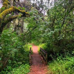
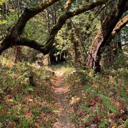
    There are several trails to explore here at Skeggs Point. Even the shortest hike will be 6 miles. Its all pretty steady and easy with beautiful Redwood Trees and just calming nature. The paths are mostly shaded which is a super plus for me. Who wants to hike in heat?! The Sandstone Formation is a must! Its a unique site to see. Quicktip: Don't forget to grab a map offered at the entrance!

    Fir Trail
    Lee A.

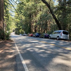
    Skeggs Point parking lot is clean, free, and has picnic tables in case you want to sit for a snack before you get your butt to hikin'. El Corte de Madera Creek Preserve is one of the most beautiful places on the Peninsula to hike. I went here a week ago in search of the infamous plane wreckage (which I believe has been swept away by the rain :(). I love the Sandstone features off the Tafoni trail! Incredible. I had a great workout and my joy was not at all dampened by the rain.

    Vinay M.

    Nice Tafoni trail with shades for summer trail. Do complete the tafoni trail and for trail loop for a 6.5 mile moderate hike. Not much vista views but definitely cold breeze and mountain bikers awaits your hiking trip.

    See all

    Photo of Lil B.
    198
    428
    1920

    4 months ago

    Helpful 2
    Thanks 2
    Love this 2
    Oh no 0

    2 years ago

    Helpful 1
    Thanks 0
    Love this 0
    Oh no 0
    Photo of Doctor G.
    1
    2405
    2

    2 years ago

    Helpful 1
    Thanks 0
    Love this 0
    Oh no 0
    Photo of Liv K.
    666
    550
    2595

    7 years ago

    Helpful 5
    Thanks 0
    Love this 4
    Oh no 0

    15 years ago

    Helpful 2
    Thanks 1
    Love this 0
    Oh no 0

    10 years ago

    Helpful 16
    Thanks 1
    Love this 13
    Oh no 0

    8 years ago

    Helpful 2
    Thanks 2
    Love this 0
    Oh no 0

    9 years ago

    Helpful 4
    Thanks 0
    Love this 1
    Oh no 0

    16 years ago

    Helpful 13
    Thanks 0
    Love this 13
    Oh no 0

    13 years ago

    Helpful 8
    Thanks 0
    Love this 4
    Oh no 0
    Photo of Sam M.
    191
    829
    1069

    13 years ago

    Helpful 3
    Thanks 1
    Love this 2
    Oh no 0
    Photo of Tae K.
    57
    38
    0

    17 years ago

    Helpful 2
    Thanks 0
    Love this 0
    Oh no 0
    Photo of John N.
    62
    29
    0

    16 years ago

    Helpful 2
    Thanks 0
    Love this 0
    Oh no 0

    13 years ago

    Definitely my favorite place to hit the trails with solid descents and challenging climbs. A must-go!

    Helpful 1
    Thanks 0
    Love this 1
    Oh no 0

    12 years ago

    Helpful 1
    Thanks 0
    Love this 0
    Oh no 0
    Photo of David H.
    205
    66
    169

    13 years ago

    Helpful 0
    Thanks 0
    Love this 0
    Oh no 0
    Photo of John S.
    34
    71
    20

    19 years ago

    Helpful 5
    Thanks 0
    Love this 2
    Oh no 0

    15 years ago

    Helpful 1
    Thanks 0
    Love this 0
    Oh no 0

    10 years ago

    Helpful 1
    Thanks 1
    Love this 0
    Oh no 0
    Photo of Joey F.
    40
    81
    0

    18 years ago

    Helpful 1
    Thanks 0
    Love this 0
    Oh no 0

    9 years ago

    Helpful 0
    Thanks 1
    Love this 0
    Oh no 0
    Photo of Jason R.
    34
    61
    24

    18 years ago

    Helpful 0
    Thanks 0
    Love this 0
    Oh no 0
    Photo of H K.
    54
    1298
    186

    14 years ago

    Helpful 0
    Thanks 0
    Love this 0
    Oh no 0
    Photo of B P.
    8
    22
    5

    12 years ago

    Helpful 0
    Thanks 0
    Love this 0
    Oh no 0

    Ask the Community - Skeggs Point

    Review Highlights - Skeggs Point

    Pit toilets available at the new lot (the one with the El Corte de Madera Open Space Preserve sign).

    Mentioned in 5 reviews

    Read more highlights

    You might also consider

    Verify this business for free

    People searched for Hiking 4,257 times last month within 15 miles of this business.

    Verify this business

    Wunderlich Park - Museum

    Wunderlich Park

    4.2(130 reviews)
    1.7 mi

    EXPERIENCE I recently visited Wunderlich Park to visit…read moretheir museum and carriage house. I didn't go for an extensive hike but want to return someday to do so! STARS (stand out qualities) -Beautiful and well maintained park -Well preserved historical site STAIRS (areas of growth) -More signage clarifying which of two entrances to enter at TIPS -Parking is limited so good to carpool or come during weekday if you can -Try signing up for tour. I learned interesting history of Chinese laborers!

    Hiked at Wunderlich Park on a sunny Saturday in March! We used AllTrails for directions and we…read morereached around 9am - to our surprise, the parking lot was full by then so definitely recommend coming earlier. There were multiple cars circling around looking for a spot as well. We ended up waiting about 30 minutes before parking. We did the Bear Gulch and Alambique trail clockwise. There are some brief steep sections, but for the most part, the trail was moderate in terms of difficulty. We didn't encounter too many people despite all the cars in the lot. We spotted a small snake on the trail and there was a lot of horse manure on the Alambique portions, so we had to watch our step closely. The trail was mostly shaded which was nice, but there wasn't much of a view. Overall, the trail was well marked and maintained (minus the manure on Alambique). Good hike for a sunny day, but the parking lot situation could be improved.

    Photos
    Wunderlich Park - Horse stables

    Horse stables

    Wunderlich Park
    Wunderlich Park

    See all

    Huddart County Park

    Huddart County Park

    4.2(140 reviews)
    3.6 mi

    I've visited the three parks in the area, Huddart, Wunderlich, and Edgewood, and Huddart is my…read morefavorite of the three. That said, all three are great and you will not go wrong with going with one over the other. Huddart is nice because it has beautifully maintained trails that are surrounded by heavily wooded redwood trees. I came across numerous deer at the upper elevations and there were a bunch of huge banana slugs. The trails are mostly easily-walkable trails. I run on a regular basis on city streets, so even for me who does occasional hikes, it can get your heart pumping on the ascents. So if you want to spend a couple of hours here, you may want to make sure you have reasonable cardiovascular stamina before going deeper into the trails. Wunderlich has some pretty long, steep ascents, whereas Edgewood is probably the easiest to hike of the three. Huddart is in the middle. The place also a lot of picnic grounds and looks like it can be reserved for parties/get togethers. There is a six dollar cash entry fee (per car), but if you are a senior you don't have to pay. Definitely will be going back to Huddart.

    I have lived in the Bay Area for over 20 years but never had the opportunity of visiting Huddart…read morePark until we were invited to a friend's kid's birthday party there. Huddart Park is such a great place if you're craving redwoods, fresh air, and well-maintained trails. The hiking options are great for all levels, with shaded paths, peaceful scenery, and plenty of spots to stop and take it all in. The picnic areas are spacious and well-kept, making this an easy choice for a relaxed day out with friends or family for a visit or a celebration. It never feels overly crowded, and the overall vibe is calm and refreshing--perfect for unplugging for a few hours. Whether you're hiking, picnicking, or just looking for a quiet place to reset, Huddart Park is a reliable favorite and absolutely worth the visit.

    Photos
    Huddart County Park
    Huddart County Park - Stinky horse!

    Stinky horse!

    Huddart County Park

    See all

    Purisima Creek Redwoods Preserve

    Purisima Creek Redwoods Preserve

    4.6(245 reviews)
    5.4 mi

    A beautiful, family-friendly place to come for a hike. There is a dedicated parking lot at the…read moretrail entrance but you can also park off the highway if the lot is full. There is a public bathroom/elevated porta potty available to use at the entrance. There are multiple trails to choose from, some being steeper or longer than others. Most of the time, you are shielded from the hot sun by the tall redwood trees that give you cool shade and that give you beautiful scenery to look at as you're walking. Because there is lots of shade, you will see moss and lichen. This environment is great for banana slug spotting - we saw two on our walk and our kids got a blast out of it. We very much enjoyed our familiy excursion here to Purisima.

    Pure Thing…read more 5,412-acre Preserve that's situated on the west side of the Santa Cruz Mountains, and features over twenty-one miles of trails. The Good: *Free! *Great place to see the venerable Coast Redwoods, which are unfortunately second-growth (±100 years old), and not old growth. *North side of the park has views of HMB coastline *Mountain biking on certain trails (check map & trail signs) *Equestrian OK on certain trails (check map and trail signage) *Banana slugs! If you love them like we do, then this place is just full of 'em! *Several different parking lots (for total) but they are limited. You'll probably have better luck at the North Ridge parking lot, as it is bigger. *Restrooms at three out of the four lots. *Redwood Trail is ADA friendly The Meh: *No dogs The Ugly: *The last part of the drive over (from the South Bay, at least) is no picnic and full of windy roads--which is great if you're the driver. Not so much if you're a passenger and you are prone to getting car sick. Conclusion: Fantastic park with lots of Redwoods and nature.

    Photos
    Purisima Creek Redwoods Preserve - Banana slug

    Banana slug

    Purisima Creek Redwoods Preserve
    Purisima Creek Redwoods Preserve - Purisima Creek Redwoods

    See all

    Purisima Creek Redwoods

    Phleger Estate

    Phleger Estate

    4.4(5 reviews)
    3.5 mi

    Beautiful and quiet park that is currently run by the Golden Gate National Recreation Area, Phleger…read moreEstate can be accessed via Huddart County park or by a roadside lot off Skyline Blvd. The benefit of parking at Huddart (albeit with a $6 parking fee) are clean restrooms and the fact you are doing most of the uphill at the start of your hike. Hiking in from Huddart, the crowds thinned and I only saw 3 other hiking groups the whole time-unusual for a beautiful Saturday in August. The park is well signed and I took the Miramontes trail which meanders along what is now a dry creek, gently uphill to a fork (again well signed) that points you to the Raymundo or Mt Redundo trails. I veered right to the Raymundo trail which is a steady but not too steep climb through mixed redwood forest and what is now a dry creek. Would love to do this trail again in rainier years to see the creek flowing and find newts and banana slugs. Still, despite a dry year, the trails were pretty green and lush. The Raymundo trail ends and another fork to the right can take you up to Skyline via the Lonely Trail or stay straight on the Mt Redundo trail which takes you back to the start of the loop and the Miramontes trail (which is out and back to Huddart County park). I headed back on Mt Redundo and it was a bit steep downhill with some roots and rocks making for uneven footing. It also has some steep ravines so mind your step. This part of the trail was eerily quiet and not as bright, so I was happy to get back to the Miramontes trail that led me back to the more well traveled Huddart County park. Really lovely park with some of the nicest redwood trails on the peninsula. Review #49 of 100 review goal in 2021

    Fantastic hike next to the more well-known Purisma Creek. We took Lonely Trail, then Raymundo…read moreTrail, then Mt. Redondo trail and back up the Lonely Trail. It was about 6 miles. There's parking on Skyline Boulevard past Kings Mountain Fire Brigade -- just a handful of spots by the side of the road. It's downhill until you get to the juncture of Raymundo and Mt. Redondo, then straight back up again. My thighs were burning up and I had to stop and rest a bunch of times. Overall, the hike too about 3 hours and 15 minutes. My favorite part was the Raymundo Trail because you hike right next to a stream. There was plenty of water in the stream, probably because it has rained recently. Actually, most of the hike was next to a stream of some sort. You could hear water the whole time which was cool. Another great thing about this hike is that it's shady the whole way. Lots of pretty redwoods to look at. There were lots of very muddy parts on this trail. Also, the Miramontes trail, which connects Mt Redondo trail to Huddart County Park, was closed, due to the rain. We ran into three other couples on the trail during our hike. Very quiet trail! Really quite a hidden gem.

    Photos
    Phleger Estate - My black truffle (13g) found near Phleger Estate, Woodside, CA

    My black truffle (13g) found near Phleger Estate, Woodside, CA

    Phleger Estate
    Phleger Estate - Once you reach the top of the Raymundo trail it gets flat for a bit

    See all

    Once you reach the top of the Raymundo trail it gets flat for a bit

    El Corte de Madera Creek Preserve - Manzanita and Gordon Mills loop hike

    El Corte de Madera Creek Preserve

    4.5(77 reviews)
    2.2 mi

    This place is stunning ! There are so many trails to choose from, and a number of parking spots so…read moreeven during late morning my husband and I were able to find parking in one of the lots. We decided to just go see the giant sandstone, which did not disappoint ! I really appreciated how well the trails were marked so that you knew clearly where you were going. On the way to the sandstone, it was also coo lto see some ocean views as well as random open fields in the dense woods here and there. Definitely a worthy hike to try ! This place is stunning ! There are so many trails to choose from, and a number of parking spots so even during late morning my husband and I were able to find parking in one of the lots. We decided to just go see the giant sandstone, which did not disappoint ! I really appreciated how well the trails were marked so that you knew clearly where you were going. On the way to the sandstone, it was also coo lto see some ocean views as well as random open fields in the dense woods here and there. Definitely a worthy hike to try !

    I have been here to hike much shorter loops several times before but I haven't hiked the most…read morebeautiful scenic 10 -mile Manzanita and Gordon Mill loop in El Corte De Madera Creek Open Space Preserve. Its a rewarding but challenging hike through towering redwoods, lush ferns, and a peaceful creek. After the last few rain storm, this trail is super wet and slippery. I highly recommend good pairs of boots and hiking poles. The Manzanita and Gordon Mills trail has a moderate elevation gain of more than 1600 feet and some serious rocky terrain. For me, it offers a great hiking challenge while I still enjoyed a mix of adventure, nature beauty, and tranquility. You can also choose a different and shorter trails to explore and experience while hiking. This preserve is very popular for hiking, bird watching, and mountain biking. So bring your binoculars to see! From All Trails: Manzanita and Gordon Mills Loop https://www.alltrails.com/trail/us/california/manzanita-and-gordon-mills-loop This is such a perfect hiking trail to explore natural beauty where we are living near by. Peace! Enjoy!!

    Photos
    El Corte de Madera Creek Preserve
    El Corte de Madera Creek Preserve
    El Corte de Madera Creek Preserve - El Corte De Madera Creek Open Space Reserve Signage

    See all

    El Corte De Madera Creek Open Space Reserve Signage

    Pulgas Ridge Open Space Preserve

    Pulgas Ridge Open Space Preserve

    4.2(146 reviews)
    6.2 mi

    Pulgas Ridge Open Space is one of the few places on the peninsula where you can hike with your dog…read more There is a small parking lot and many spaces out along the road where you can park. If you don't come early on the weekends, parking might be an issue, but there are so many people coming and going, you'll probably get a spot eventually. Our pup is can't handle seeing other dogs, so taking the narrow entrance from the parking lot is a bit crazy for us. We typically enter from the side where you and your pup can walk on cement trails for about a half a mile before there is an off-leash zone. We usually take the main trail ALL the way up until the trail stops (and you can see the back side of a vista point) and we return back down. Its a lot of uphill walking, so be prepared to bring water if it gets hot. I enjoy this spot, but last time we found a tick on my dogs ear! Be careful when going on this trail.

    Dog friendly park! Super sad because the Cordilleras Trail was closed for construction and will be…read morethrough the end of July :( I came with two friends to have a cute mommy date with their babies in strollers and had to drive to a new park. We will definitely come back again once it's open! 4/5 stars for the closure and only one restroom made available at the parking lot (I also did not see a water bottle/fountain filling station) Parking: There's a free parking lot (fits ~20 cars) and ample street parking if it's filled. I recommend coming on a week day to secure a parking spot Easy Trail: the cordilleras trail is wheelchair and stroller friendly! It's a 0.3 mile flat trail that breaks off into other trails leading to the dog park or towards the creek. This trail is paved, so no worries about bumpy roads or muddy patches Moderate Trail: the blue oak trail has a steep incline immediately at the start of the hike. It zig zags and is a ~200 ft elevation increase for 0.4 miles. It gets dusty but is doable due to the many trees for shade. It leads directly to the off leash dog area

    Photos
    Pulgas Ridge Open Space Preserve - Pulgas Ridge Preserve trail map https://www.openspace.org/preserves/pulgas-ridge

    Pulgas Ridge Preserve trail map https://www.openspace.org/preserves/pulgas-ridge

    Pulgas Ridge Open Space Preserve
    Pulgas Ridge Open Space Preserve - View near the start of the Hassler tail's loop

    See all

    View near the start of the Hassler tail's loop

    Skeggs Point - hiking - Updated May 2026

    Loading...
    Loading...
    Loading...