Huddart County Park Photos


You might also consider
More like Huddart County Park
Recommended Reviews - Huddart County Park
Start your review...

Reviews With Photos

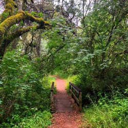
I did my first 50k/33 miles + hike here, about 4,500 elevation gain. It was "+" because we got lost several times and did some extra credit. Amazing connecting trails and only some parts are overgrown. There are large redwood trees and a good size creek running through the park. There were a lot of hikers and bicyclists on the trail. There is poison ivy and oak on the trail in June. I saw deers, quails, rabbits, snakes, and possibly a mountain lion. We came at 8:00am and the park closed at 8:00pm. We exited at 8:04pm because of the lost situation. Parking is $6.00. Great experience overall. Good views. Please come and create your own adventure.

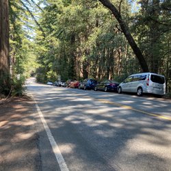
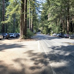
Beautiful tree packed park with loads of trails. We ended up hiking a few different trails due to intersections and trail closures. All areas we hiked were beautiful and had similar landscape. All trails seemed to have decent amount of elevation gain to start or finish, but it wasn't anything too difficult if you're in moderate shape. The signage on the trails was pretty clear, and even better with one of the maps from the front. The trail markers all had numbers that corresponded to the map, so figuring out where you were was easy. We came on a beautiful Saturday afternoon in the fall and had plenty of parking still available. It is a slightly windy trek to get up here, but it doesn't take too long and is well worth it for the beauty once you're in. Parking is $6 since it is a county park.

We go hiking at Huddart Park all the time with our little ones, and it's truly one of our favorite spots! The trails are easy to navigate, not confusing at all, and our kids are able to walk all the way up and down without any issues--which says a lot! There are plenty of picnic stops along the way, and we love that there's a small playground for the kids to enjoy afterward. We usually pack a lunch and make a day of it--hike first, then relax and eat together. It's peaceful, clean, and the perfect spot for families to get outdoors. Highly recommend if you're looking for a fun and easy nature escape close to the city!


Location : at the end of Kings Mountain Road, Woodside CA (24 minutes from Cupertino CA) Narrow winding road to get there. Not my favorite:/ Great for picnics as there are tons of picnic tables and bbq grills throughout the park amongst the tall redwood trees. However we had hard time finding good trails to hike on. It's just my opinion but this park is great for picnics and bbq but not sure it's great for long distance hiking. We wanted to hike to the campground but the trail was closed as of June 24,2023 so I'm not sure if the whole campground is closed also or not. I personally prefer El Corte de Madera, Rancho San Antonio and Rancho Canada del Oro in this area for hiking. Ps I just hate the narrow winding road to get there. People drive so fast on those roads.

Stunning park! I am surprised that I have not been here before. I was here volunteering on MLK day yesterday and spent a few hours raking and cleaning up. I got to spend some time with the Park Rangers who are awesome. Angel is particular was super friendly and helpful. They are doing great work and they have a cool job. I will be back for sure for more leisurely hiking and to hang out. Note that the path to get here is windy, so please drive carefully.

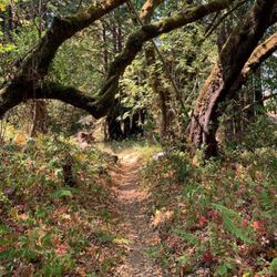
Huddart County Park is a really, truly beautiful park with beautiful views and tons upon tons of redwood trees! The whole vibe when you enter the forest is mystical almost. I went on a specific trail that said would be a 5 mile loop. It ended up being a 6.35 mile loop with ~1000 ft in elevation! It was not too difficult at all, but I am definitely feeling it in my legs today. The views are beautiful and I constantly found myself stopping to look in awe at the beauty of the forest. I even found myself stopping talking and just simply taking in the sounds and stillness of the forest. It was such a beautiful time. I highly recommend coming here and checking it out!

Huddart park is an example of one of my favorite things about SF. A short drive from the city, and you are already surrounded by so much nature. If you like john muir woods but hate crowds and paying bridge toll, look no further! Come by to Huddart and make sure you bring cash. Parking is $6. I recommend going on the eastern trails, they're very scenic. My favorite was the south eastern section. Bay view trails turn into something road trail.

**COVID Review** We came on a Saturday afternoon around 1pm and there were a bunch of empty parking spots. It cost $6 for parking and you have to go by the front entrance to put the money in the envelope. Make sure to bring exact change! We hiked the crystal springs trail and because some of the way through the trail was closed, we used Richards road trail to go back to the crystal springs trail. We then used the fire road to get back to our car. The trails were mostly covered and in shade which was super nice! Definitely would love to come back and hike other trails.

Came on early Saturday morning for a hike around the Crystal Spring trail which is lined with redwood trees. The trail has a nice mix of uphill and downhill although there are parts of the road that are pretty uneven to walk on. Bathrooms are very clean. A lot of the picnic benches are closed due to COVID-19 but there are still many other places for a small break. There's also a $6 vehicle entry fee. Some Tips: - Come EARLY. The park starts to fill up at 9am and parking could be a problem. - Pull up Google Maps on your phone before going in because there is no data inside the park and the trail signs are not very clear. - Bring $6 in cash, there's nobody really to get change. - Bring a hat, even though most parts of the walk is shaded, there is still a lot of places where there's a lot of sun.

Well kept park in San Mateo, Huddart County Park features miles of hiking trails that link to other county parks and can be quite busy. At the main park staging areas, you will find several picnic areas, volleyball courts and lots of weekend crowds. Trails are well kept and well signed and once you get further in the park, the crowds thin out. I came here as a jumping off point for a hike in to Phleger Estate (which is separately run by Golden Gate National Recreation Area-separate review to follow.) Having spent only a mile or so on the trails of Huddart Park, I can't give a full review of the hikes available but can say I spent time in the Crystal springs Trail which was wonderfully shaded and featured some redwoods. From there I left the park to hike the Phleger trail. $6 cash only to park, clean restrooms and easy access from Highway 280 make this a popular park. Review #48 of 100 review goal in 2021

Huddart is such a wonderful and pretty park. It's got 14 trails: Archery Fire Road, Bay Tree trail, Campground trail, Canyon trail, Chaparral trail, Chickadee Nature trail, Chinquapin trail, Crystal Springs trail, Dean trail, Kings Mountain trail, Redwood Nature trail, Richard's Road trail, Skyline Trail, Summit Springs Fire Road. There are also 11 reservable facilities in five group picnic areas that you can reserve for your family. There are picnic tables, serving tables, volleyball poles, horseshoe pits, BBQs, and covered structures. One of my favorite hikes is Crystal Springs. It's covered, has beautiful trees, well marked and makes for a great up and back trail that covers 8 miles round trip. Remember to bring some cash. This park has an entrance fee.

Where has this park been this whole time I have been in the Bay Area?! This is a great park to have a picnic or go on a hike. It's a very secluded park but I believe only locals or close residences knows about it. It's very close to HWY 280 by Woodside or Redwood City. For a Saturday, the park was not too busy? It's very green with many trees for shade. There is plenty of parking, activities and picnic tables to have a party?! There is plenty of bathrooms to use as well. We actually came here to hike the Crystal Springs Trail to Dean's Trail. We were surprised it was actually a County Park that you have to pay $6 cash car entrance but still worth it. The park was well maintained. There are other trails to take here as well. The hike trail we took was good where it was not strenuous or climbing over rocks or rivers. Even our parents could take the trail for senior citizens. There was plenty of shade I didn't need to wear a hat. The hike was a little over two hours to two and a half depending on if you get lost like us?! My leads took the wrong way while I was using AllTrails app. While I am on a mission to try all the hike trails I can do in the Bay Area. I would come back to these trails or just have a big family picnic! Definitely recommend this place as it's a beautiful park. [33/100]

6 months ago
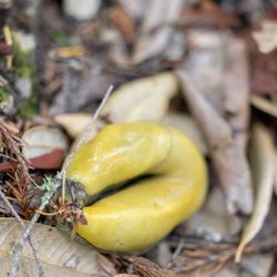
I've visited the three parks in the area, Huddart, Wunderlich, and Edgewood, and Huddart is my favorite of the three. That said, all three are great and you will not go wrong with going with one over the other. Huddart is nice because it has beautifully maintained trails that are surrounded by heavily wooded redwood trees. I came across numerous deer at the upper elevations and there were a bunch of huge banana slugs. The trails are mostly easily-walkable trails. I run on a regular basis on city streets, so even for me who does occasional hikes, it can get your heart pumping on the ascents. So if you want to spend a couple of hours here, you may want to make sure you have reasonable cardiovascular stamina before going deeper into the trails. Wunderlich has some pretty long, steep ascents, whereas Edgewood is probably the easiest to hike of the three. Huddart is in the middle. The place also a lot of picnic grounds and looks like it can be reserved for parties/get togethers. There is a six dollar cash entry fee (per car), but if you are a senior you don't have to pay. Definitely will be going back to Huddart. read more


I did my first 50k/33 miles + hike here, about 4,500 elevation gain. It was "+" because we got lost several times and did some extra credit. Amazing connecting trails and only some parts are overgrown. There are large redwood trees and a good size creek running through the park. There were a lot of hikers and bicyclists on the trail. There is poison ivy and oak on the trail in June. I saw deers, quails, rabbits, snakes, and possibly a mountain lion. We came at 8:00am and the park closed at 8:00pm. We exited at 8:04pm because of the lost situation. Parking is $6.00. Great experience overall. Good views. Please come and create your own adventure. read more


Beautiful tree packed park with loads of trails. We ended up hiking a few different trails due to intersections and trail closures. All areas we hiked were beautiful and had similar landscape. All trails seemed to have decent amount of elevation gain to start or finish, but it wasn't anything too difficult if you're in moderate shape. The signage on the trails was pretty clear, and even better with one of the maps from the front. The trail markers all had numbers that corresponded to the map, so figuring out where you were was easy. We came on a beautiful Saturday afternoon in the fall and had plenty of parking still available. It is a slightly windy trek to get up here, but it doesn't take too long and is well worth it for the beauty once you're in. Parking is $6 since it is a county park. read more


1 year ago
We go hiking at Huddart Park all the time with our little ones, and it's truly one of our favorite spots! The trails are easy to navigate, not confusing at all, and our kids are able to walk all the way up and down without any issues--which says a lot! There are plenty of picnic stops along the way, and we love that there's a small playground for the kids to enjoy afterward. We usually pack a lunch and make a day of it--hike first, then relax and eat together. It's peaceful, clean, and the perfect spot for families to get outdoors. Highly recommend if you're looking for a fun and easy nature escape close to the city! read more


1 year ago


Location : at the end of Kings Mountain Road, Woodside CA (24 minutes from Cupertino CA) Narrow winding road to get there. Not my favorite:/ Great for picnics as there are tons of picnic tables and bbq grills throughout the park amongst the tall redwood trees. However we had hard time finding good trails to hike on. It's just my opinion but this park is great for picnics and bbq but not sure it's great for long distance hiking. We wanted to hike to the campground but the trail was closed as of June 24,2023 so I'm not sure if the whole campground is closed also or not. I personally prefer El Corte de Madera, Rancho San Antonio and Rancho Canada del Oro in this area for hiking. Ps I just hate the narrow winding road to get there. People drive so fast on those roads. read more


Stunning park! I am surprised that I have not been here before. I was here volunteering on MLK day yesterday and spent a few hours raking and cleaning up. I got to spend some time with the Park Rangers who are awesome. Angel is particular was super friendly and helpful. They are doing great work and they have a cool job. I will be back for sure for more leisurely hiking and to hang out. Note that the path to get here is windy, so please drive carefully. read more


Huddart County Park is a really, truly beautiful park with beautiful views and tons upon tons of redwood trees! The whole vibe when you enter the forest is mystical almost. I went on a specific trail that said would be a 5 mile loop. It ended up being a 6.35 mile loop with ~1000 ft in elevation! It was not too difficult at all, but I am definitely feeling it in my legs today. The views are beautiful and I constantly found myself stopping to look in awe at the beauty of the forest. I even found myself stopping talking and just simply taking in the sounds and stillness of the forest. It was such a beautiful time. I highly recommend coming here and checking it out! read more

3 years ago
Huddart park is an example of one of my favorite things about SF. A short drive from the city, and you are already surrounded by so much nature. If you like john muir woods but hate crowds and paying bridge toll, look no further! Come by to Huddart and make sure you bring cash. Parking is $6. I recommend going on the eastern trails, they're very scenic. My favorite was the south eastern section. Bay view trails turn into something road trail. read more


**COVID Review** We came on a Saturday afternoon around 1pm and there were a bunch of empty parking spots. It cost $6 for parking and you have to go by the front entrance to put the money in the envelope. Make sure to bring exact change! We hiked the crystal springs trail and because some of the way through the trail was closed, we used Richards road trail to go back to the crystal springs trail. We then used the fire road to get back to our car. The trails were mostly covered and in shade which was super nice! Definitely would love to come back and hike other trails. read more


6 years ago
Came on early Saturday morning for a hike around the Crystal Spring trail which is lined with redwood trees. The trail has a nice mix of uphill and downhill although there are parts of the road that are pretty uneven to walk on. Bathrooms are very clean. A lot of the picnic benches are closed due to COVID-19 but there are still many other places for a small break. There's also a $6 vehicle entry fee. Some Tips: - Come EARLY. The park starts to fill up at 9am and parking could be a problem. - Pull up Google Maps on your phone before going in because there is no data inside the park and the trail signs are not very clear. - Bring $6 in cash, there's nobody really to get change. - Bring a hat, even though most parts of the walk is shaded, there is still a lot of places where there's a lot of sun. read more

5 years ago
Well kept park in San Mateo, Huddart County Park features miles of hiking trails that link to other county parks and can be quite busy. At the main park staging areas, you will find several picnic areas, volleyball courts and lots of weekend crowds. Trails are well kept and well signed and once you get further in the park, the crowds thin out. I came here as a jumping off point for a hike in to Phleger Estate (which is separately run by Golden Gate National Recreation Area-separate review to follow.) Having spent only a mile or so on the trails of Huddart Park, I can't give a full review of the hikes available but can say I spent time in the Crystal springs Trail which was wonderfully shaded and featured some redwoods. From there I left the park to hike the Phleger trail. $6 cash only to park, clean restrooms and easy access from Highway 280 make this a popular park. Review #48 of 100 review goal in 2021 read more


Huddart is such a wonderful and pretty park. It's got 14 trails: Archery Fire Road, Bay Tree trail, Campground trail, Canyon trail, Chaparral trail, Chickadee Nature trail, Chinquapin trail, Crystal Springs trail, Dean trail, Kings Mountain trail, Redwood Nature trail, Richard's Road trail, Skyline Trail, Summit Springs Fire Road. There are also 11 reservable facilities in five group picnic areas that you can reserve for your family. There are picnic tables, serving tables, volleyball poles, horseshoe pits, BBQs, and covered structures. One of my favorite hikes is Crystal Springs. It's covered, has beautiful trees, well marked and makes for a great up and back trail that covers 8 miles round trip. Remember to bring some cash. This park has an entrance fee. read more

Where has this park been this whole time I have been in the Bay Area?! This is a great park to have a picnic or go on a hike. It's a very secluded park but I believe only locals or close residences knows about it. It's very close to HWY 280 by Woodside or Redwood City. For a Saturday, the park was not too busy? It's very green with many trees for shade. There is plenty of parking, activities and picnic tables to have a party?! There is plenty of bathrooms to use as well. We actually came here to hike the Crystal Springs Trail to Dean's Trail. We were surprised it was actually a County Park that you have to pay $6 cash car entrance but still worth it. The park was well maintained. There are other trails to take here as well. The hike trail we took was good where it was not strenuous or climbing over rocks or rivers. Even our parents could take the trail for senior citizens. There was plenty of shade I didn't need to wear a hat. The hike was a little over two hours to two and a half depending on if you get lost like us?! My leads took the wrong way while I was using AllTrails app. While I am on a mission to try all the hike trails I can do in the Bay Area. I would come back to these trails or just have a big family picnic! Definitely recommend this place as it's a beautiful park. [33/100] read more


6 years ago
Huddart Park is a beautiful refuge from the forever-busy Bay Area that's well maintained and accessible for all. I grew up attending summer camp here throughout my k-12 years and have so many happy memories at Huddart in the Oak, Meadow, Sequoia, and Redwood areas as well as hiking throughout the park. The facilities are very well taken care of (roads, bathrooms, etc) with plenty of signage around for trails. There are multiple parking lots (though some are currently closed for COVID) and a $6 fee to park. A lovely way to spend a few hours outdoors! read more


3 years ago
I was with my family and had a good time. everything is convenient, entrance fee for one car is $6. there are places for walking and barbecue. I recommend it for Bay Area residents and guests as well! read more

3 years ago
This place is huge with lots of trails that are shaded by tall redwoods. There are also lots of picnic areas, although most are roped off due to covid. We took the Crystal Springs trail, but it was cut short due to bridge renovations. The trails are well marked, so we easily found another trail. The trails are mostly shady, but watch out for horse poop. Other pluses include decent bathrooms and lots of parking ($6 per day though). I'd definitely come back in the spring and hopefully see some water in the creeks. read more


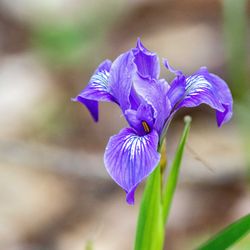
Looks like a great place to picnic, BBQ, play a game of sandcourt volleyball, hike any of several trails, even camp. You do have to pay $6 parking. There are decent restrooms near the picnic areas that have TP, water and hand airdryer. Best to bring your own hydration. The trails are well have signs so be sure to pick up a map at the front entrance where you paid for parking. I was disappointed not to see much of the Bay Area views from the Crystal Springs trail near Toyon campground that I took. May be if I hiked up to Skyline there may be a view. Much of the trail is in the woods/forest. Some wildflowers this spring time hike read more


My friend and I decided to go hiking last minute, so we picked Huddart Park because it was nearby. No regrets! The park is really huge, with quite a number of trails, as well as other facilities such as camp sites, barbecue/picnic areas, and a small playground. The park is equestrian friendly, too! Some of the trails were crowded/busy, but we managed to mostly avoid the crowds. Most of the trails we were on were shady and not too hot. The trails were easy/moderate difficulty (no crazy inclines -- think more of a casual stroll through the woods); definitely good park for jogging. I'd definitely go again and spend more time exploring parts of the park I didn't get to see this time around. As a heads up, there is a $6 fee at the main entrance, but there's ample parking inside. Some of the facilities are reservation-only, so I'd recommend checking it out in advance before organizing big events. read more

Very nice escape from the surrounding downtown/suburban area with a shaded patch of woods and a set of interesting wooden bridges and treehouses! Saw plenty of high school-aged children here hanging out after school and came across a few biking home from school, so I'd recommend keeping your music down to make sure you don't get run over by a speeding bike! The area of restaurants right next door includes a unique Japanese spot that serves the most interesting, sweet eggplant ever- can't recall the name of the restaurant myself so please let me know if you know the spot I'm talking about! read more


4 Stars for a gorgeous park with trails that make you want to push yourself just to delve deeper into the natural setting! I'm a fan of hiking (of the fairly light variety) and found myself on an impromptu hike with some coworkers at a work retreat at Huddart Park. Right away as you enter on a trip you realize you're in for something special. The trees are incredibly tall and shade the majority of the trails, which is great since you'll be hot from exertion! I'd say it is a pretty moderate hike but I would still say you need to have a healthy respect for the terrain. Overall we must have hiked for an hour and we got back feeling invigorated by the incredible scenery and clean air. One note I'd make is that the signs aren't the most clear, so be sure to take a map. It would be great if they updated the signage because there were a few times, even with a map, that we had a hard time figuring out where we were. Overall, Huddart Park is a great spot for hiking and apparently for horses as well (that's my not to subtle reference to the "land mines" on the trails)! read more

Updated 6/23/07: Some friends & I went here on a short loop hike. Parking is $5 as of 6/23/07. They have a Entrance station where someone collects the money & gives you a receipt to put on your dashboard. We parked at Miwok area where there is are flushed men/women toilets. Then we did about 5 miles starting on the Dean Trail to Crystal Springs Trail, back to Dean Trail. We missed one turnoff because there wasn't a sign there. Hate that. Lots of runners at this park today. ----------------------- i like Huddart County Park. I don't have too many pics here I wonder why, but it's a nice park. Lots of tree and you can see horses sometimes. read more


3 years ago
I grew up exploring this area and learning to drive on its winding roads. I pibe this park it is beauty at its finest and close to the city. I didn't have much time today but needed to be in nature and this was the perfect park for that. 5 stars!! read more


$6 vehicle entry fee. Went on the Crystal Springs/Dean Trail, which was about 4.6 miles round trip. Loved that this particular hike did not allow bikers. A good balance of uphill and downhill. All of the bathrooms we could find were closed due to COVID-19. There were a lot of people in the parking lot, but the trail wasn't too bad. A challenging, but worthwhile hike. read more


6 years ago
This was a beautiful park, we did 7 miles trail loop. They charge $6 (cash only) for parking which is not bad at all and the bathroom were so clean. read more


Have you ever passed by a park and thought to yourself, "Gee, why haven't I seen this before???" That's exactly how I felt about Huddart County Park. Recently, my company held a picnic at Woodside's Huddart County Park. This open-space area is one of MANY that are lined all along the San Francisco Bay Area's Peninsula region.The nice thing about this park is that it's EASILY accessible from the freeway. Usually for many parks in the area, you have to drive at least 15-20 minutes down windy paths before reaching the parking area. But luckily for Huddart, it's only like 10 minutes AT MOST from the 280 Freeway's Woodside exit. And it was no more than 15 from Menlo Park where we worked. There's PLENTY of parking (especially on a weekday) inside this park, and it's about $5 or so for entrance. If you are looking for an outdoor adventure in the Peninsula to take your kids to on the weekend, look no further than Huddart County Park. For those few hours there, I felt sheer bliss. Huddart is BEAUTIFUL. Especially in the summer time, the weather is perfect, birds are chirping, and the scenery is gorgeous. Don't worry about the heat because there's PLENTY of shade everywhere. For our picnic, we set up shop at Zwierlein, and it was AWESOME. There were a bunch of tables + GAME areas too! There's a volleyball court, a station for corn hole toss, AND there's even a horseshoe toss court (you can borrow at the gate). The only real downside is that they don't allow dogs (sorry puppers). All in all, I know that I will be coming back to Huddart County Park. I give this place an "omg, I'd drive 2 hours for this" rating. Huddart is the PERFECT place in the area for a nice and quiet picnic. There's so much to do and so much to see here. I'll definitely have to check out the trails next time! read more


6 years ago
Once the site of extensive logging operations circa the 1850s, the Huddart County Park is like the Disneyworld of redwood tree parks. You'll see what I mean when you find this gem of a park and drive around the windy, looping, roads between picnic areas and entry points for hiking. There is a seemingly endless array of places to park and areas for picnics (e.g. large spaces with tons of picnic tables and BBQ pits). In addition, they have a playground. As far as the trails and hiking, this area is canyon-like with several ridges. When you see the map of the trails you'll likely be overwhelmed because it's a mazelike offering of hikes. I believe there's almost 1000 acres to explore. The park is amazing due to the second-growth canopy of redwoods looming above you; they provide lots of shade and keep it nice and cool during warmer months. As noted, this was once an area heavily logged during the Gold Rush era so these trees are around a 100 or so years old and considered second-growth. However, they're still amazing. The key to enjoying hikes here is just being open to exploring and reading the map to coordinate with the matrix of numbered sign posts. Yes, you could get lost if you just meander without reading maps and paying attention. I was also impressed with the other amenities (e.g. clean and plentiful bathrooms) and space for mountain biking and horseback riding. The entrance fee is 6$. read more


7 years ago
A well-maintained park on the eastern slope of the Santa Cruz Mountains, 10 minutes west of downtown Woodside. (Entrance fee is $6 per car). Since it primarily encompasses an upland plateau and several forested canyons, it doesn't have the greatest views, but it is quiet and shady. the lower side offers short loop hikes that can be easily traversed by kids. In years past, we've also enjoyed the very large, lower meadow area (http://www.yelp.com/biz_photos/I7RbGBA2L6CLLznr5d6ToQ?select=bnDL-GfbsQ37WFSddYwXVg) (http://www.yelp.com/biz_photos/I7RbGBA2L6CLLznr5d6ToQ?select=xGP7OdZQy9RTKLRUvCtM1g) where we could setup a picnic, and the kids could run around, explore, climb a tree, play ball, or look for deer in the adjacent woods. It is just a short walk in from parking. Likes: - Not too crowded (most of the time) - LOTS of trees (primarily redwood, bay, bigleaf maple and tanoak) - Perfect trail running spot - Upper and lower meadow areas for running and play - Frequent horses (because the kids enjoy seeing them) Don't likes: - The drive-up picnic areas and upper meadow can get overrun on summer weekends - Frequent horses (because they create trail-landmines) On our last visit we went on a somewhat cloudy, winter day, and I geeked-out on all the trailside fungus from recent rains: (http://www.yelp.com/biz_photos/I7RbGBA2L6CLLznr5d6ToQ?select=vF4M4Dm8g6ZvAzq2Epgf_g) (http://www.yelp.com/biz_photos/I7RbGBA2L6CLLznr5d6ToQ?select=fLHKdBS-AZcZ7eSYtPNuzg). It just proves to me it's a park for all seasons. Hike Spot 'Other Info' Checklist:: -- Parking: Yes - several inside the main entrance -- Bathrooms: Yes; multiple locations; pretty nice -- Potable water: Yes -- Maps provided: Yes -- Highlights: Two large grass meadows; lots of picnic spots; shady hiking in the Redwoods My Peninsula Hike Collection is here: (https://www.yelp.com/collection/qBI6U6Lz9LJQjnGjFW6ubg) read more

 - Parks Near Me - Woodside, California")


Page 1 of 4
More info about Huddart County Park
1100 Kings Mountain Rd
Woodside, CA 94062
Directions
(650) 851-1210
Call Now
Visit Website
http://parks.smcgov.org/huddart-park
Hours
Indoor Amenities
Outdoor Amenities
Huddart County Park Reviews in Other Languages
Ask the Community - Huddart County Park
Review Highlights - Huddart County Park
You might also consider


Why does Yelp recommend reviews?
8 reviews that are not currently recommended
The reviews below are not factored into the business's overall star rating.
1 year ago
4 years ago
15 years ago
13 years ago
13 years ago
1 year ago
15 years ago
Huddart County Park - parks - Updated August 2026
Best of Woodside
People found Huddart County Park by searching for…
Trending Searches in Woodside, CA
Blueberry Picking near Huddart County Park
Boardwalk near Huddart County Park
Boating near Huddart County Park
Cinema near Huddart County Park
Cliff Jumping near Huddart County Park
Cruising Spots near Huddart County Park
Day Trips near Huddart County Park
Dog Friendly Beaches near Huddart County Park
Dog Friendly Things To Do near Huddart County Park
Flower Fields near Huddart County Park
Free Picnic Areas near Huddart County Park
Indoor Mini Golf near Huddart County Park
Jet Ski Rental near Huddart County Park
Kayak Rental near Huddart County Park
Kids Activities Indoor near Huddart County Park
Lakes near Huddart County Park
Lookout Points near Huddart County Park
Outdoor Activities near Huddart County Park
Parks near Huddart County Park
Peach Picking near Huddart County Park
Playgrounds near Huddart County Park
Public Beaches near Huddart County Park
River Swimming near Huddart County Park
Rock Quarry near Huddart County Park
Scenic Drive near Huddart County Park
Scenic Overlook near Huddart County Park
Sunrise View near Huddart County Park
Surf Shop near Huddart County Park
Swimming Holes near Huddart County Park
Things To Do On A Rainy Day near Huddart County Park
Things To Do With Kids near Huddart County Park
Watch Sunset near Huddart County Park
Browse Articles
Browse Nearby
BEST of Woodside, California Restaurants near Huddart County Park
BEST of Woodside, California Coffee near Huddart County Park
BEST of Woodside, California Things to Do near Huddart County Park
BEST of Woodside, California Playgrounds near Huddart County Park
BEST of Woodside, California Picnic Areas near Huddart County Park
BEST of Woodside, California Breakfast near Huddart County Park
BEST of Woodside, California Star Gazing near Huddart County Park
BEST of Woodside, California Campgrounds near Huddart County Park
BEST of Woodside, California Sightseeing near Huddart County Park
Browse Brands
Related Searches in Woodside, CA
Best Dog Hiking Trails Around Woodside, California
Best Fishing Locations and Guides in Woodside, California
Best Nature Trails for Hiking in Woodside, California
Best Off Leash Dog Parks in Woodside, California
Best Parks for Parties and Events in Woodside, California
Best Places for Horseback Riding in Woodside, California
Best Sightseeing Experiences Available in Woodside, California
Best Water Parks for Kids in Woodside, California
Check Out Great Playgrounds in Woodside, California
Check Out Off Road Trails in Woodside, California
Discover Baseball Fields Around Woodside, California
Discover Dog Friendly Trails to Explore in Woodside, California
Discover Easy Hiking Trails Near Woodside, California
Discover Fun Toddler Parks in Woodside, California for Your Little One
Discover Kid Friendly Hiking Trails in Woodside, California
Discover Lakes & Ponds to Explore in Woodside, California
Discover Popular Bike Trails in Woodside, California
Discover Popular Photo Spots in Woodside, California
Discover Soccer Fields in Woodside, California Near You
Discover Top Nature Parks to Visit in Woodside, California
Discover Top State Parks to Visit in Woodside, California
Discover Walking Parks in Woodside, California Near You
Discover a Hiking Trail in Woodside, California
Discover the Best Beaches in Woodside, California
Discover the Best Kids Park Spots in Woodside, California
Discover the Best Night Hike Trails in Woodside, California
Dog-Friendly Hikes With Dogs in Woodside, California
Enjoy Camping Adventures Around Woodside, California
Enjoy Kayaking Adventures in Woodside, California
Enjoy Off Leash Dog Hikes in Woodside, California
Enjoy Scenic Places to Walk in Woodside, California
Enjoy a Beautiful Waterfall Hike in Woodside, California
Enjoy the Best Picnic Spots and Ideas in Woodside, California
Enjoy the Best Walking Path in Woodside, California
Enjoy the Best Walking Trails in Woodside, California
Explore Beautiful Parks and Green Spaces in Woodside, California
Explore Easy Hikes Perfect for All in Woodside, California
Explore Free Picnic Areas Around Woodside, California
Explore Fun Activities to Do in Woodside, California
Explore Parks With Pull Up Bars in Woodside, California
Explore Picnic Parks Near Woodside, California
Explore Popular Campgrounds Near Woodside, California
Explore Popular Dog Walking Trails in Woodside, California
Explore Popular Kids Parks Throughout Woodside, California
Explore Popular Picnic Areas Around Woodside, California
Explore Popular RV Parks Around Woodside, California
Explore Scenic Lakes to Visit in Woodside, California
Explore Top Dog Parks in Woodside, California Near You


