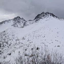
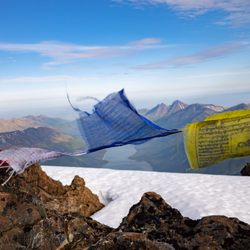
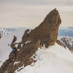
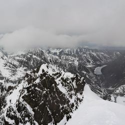
Ascending Path Photos


You might also consider
More like Ascending Path
Recommended Reviews - Ascending Path
Start your review...

Reviews With Photos
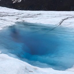
If I could give this place 10 stars I would! They were worth every penny!! We did the helicopter glacier tour and it was an overwhelmingly incredible experience from start to finish. The staff is so friendly, professional and made us feel safe. we had a one of a kind experience hiking on the glacier finding blue water, ice caves, learning the history of the glacier and the lands that surround it.... we witnessed wildlife like moose, mountain goats and black bears... a once in a lifetime experience!
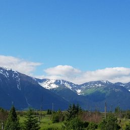
I signed up for the $379 kayak and glacier hike in Spencer lake. It was one of the most amazing experiences I have. It was really worth it. The train ride from anc to Spencer and back was mind blowing. It was like u r in a painting or inside a wallpaper! We were a small group, 4, plus our guide. It was really an amazing amazing kayak and hiking trip. Don't forget to drink glacier water!! ;)

7 years ago
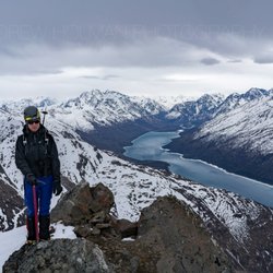
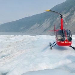
Take the helicopter glacier hike tour! You will not regret it!! My husband and I were second guessing such a big ticket item for our Alaska trip but we agree it was worth it! Our trip would not have been the same had we skipped this standout experience! Our guides Andy and Matt were amazing! We had a lot of fun with them and learned a lot too. Thank you guys for the memories! Until you see and walk on a glacier, you cannot understand the scale and size of one! There are hidden worlds when you get on the ice! Waterfalls into the abyss, hidden ice caves, lakes of deep aqua blue... and it goes on and on in every direction. Completely insane! Do yourself a favor and book this trip. The views from the helicopter alone are worth it, but exploring a glacier is priceless! read more


9 years ago
Did the spencer glacier kayak and hike, starting from the Alyeska Resort. $379pp (occasional coupons on their Facebook). This took about 9 hours, with about 5 hours being kayak + hike. The rest was transportation/waiting for train/etc. Prices are high, but the experience is pretty amazing. It's hard to do activities or get up close to glaciers without assistance/guides. The group to guide ratio is low so you're definitely safe. I love the energy from the guides. They know what they're doing and they are so enthusiastic about it. They definitely take care of you if you're a newb to all this. Amazing views. Amazing pictures. Would recommend! read more


13 years ago
I took my parents Glacier Hiking at Spencer Glacier via Ascending Path and the entire experience from reserving to the actual hike itself was positive. Our guides were Matt and Kaitlin. Both of whom were extremely experienced and made the trip enjoyable for everyone which ended up just being my parents myself and Matt and Kaitlin. The Spencer Glacier hike involved a train trip from Anchorage to the glacier which also went through Girdwood, Portage and Whittier, so you got to see a lot! From the train stop we kayaked to the glacier, Matt and Kaitlin gave us our crampons at the glacier and they coached us throughout the hike as it was our first time wearing crampons. Because of our skill level we didn't make it very far up the glacier but the cost of the trip was completely worth the entire experience. I'd love to do another trip with Matt and Kaitlin! read more


8 years ago
If I could give this place 10 stars I would! They were worth every penny!! We did the helicopter glacier tour and it was an overwhelmingly incredible experience from start to finish. The staff is so friendly, professional and made us feel safe. we had a one of a kind experience hiking on the glacier finding blue water, ice caves, learning the history of the glacier and the lands that surround it.... we witnessed wildlife like moose, mountain goats and black bears... a once in a lifetime experience! read more


8 years ago
6 years ago
6 years ago
9 years ago
I signed up for the $379 kayak and glacier hike in Spencer lake. It was one of the most amazing experiences I have. It was really worth it. The train ride from anc to Spencer and back was mind blowing. It was like u r in a painting or inside a wallpaper! We were a small group, 4, plus our guide. It was really an amazing amazing kayak and hiking trip. Don't forget to drink glacier water!! ;) read more


7 years ago
7 years ago
15 years ago
7 years ago
10 years ago
Heather and Ellie were awesome guides for our crew of 10 guys kayaking next to icebergs and hiking Spencer Glacier. Such a cool experience! I highly recommend this company and this amazing experience in Alaska. read more


7 years ago
13 years ago
10 years ago
More info about Ascending Path
1000 Arlberg Ave
Girdwood, AK 99587
Directions
(907) 783-0505
Call Now
Visit Website
https://www.ascendingpath.com
Hours
Outdoor Amenities
Other Amenities
From the Business
Ask the Community - Ascending Path
Review Highlights - Ascending Path


Why does Yelp recommend reviews?
5 reviews that are not currently recommended
The reviews below are not factored into the business's overall star rating.
7 years ago
8 years ago
8 years ago
7 years ago
7 years ago
Ascending Path - climbing - Updated July 2026
Best of Girdwood
People found Ascending Path by searching for…
Campgrounds in Girdwood, Alaska
Places to Take Pictures in Girdwood, Alaska
Things to Do in Girdwood, Alaska
Hiking Trails in Girdwood, Alaska
Indoor Swimming Pools in Girdwood, Alaska
Rock Climbing Gyms in Girdwood, Alaska
Things to Do on a Rainy Day in Girdwood, Alaska
Helicopter Rides in Girdwood, Alaska
Boat Charters in Girdwood, Alaska
Aerial Tours in Girdwood, Alaska
Helicopter Tour in Girdwood, Alaska
Travel Services in Girdwood, Alaska
Ghost Tour in Girdwood, Alaska
Waterfalls in Girdwood, Alaska
Boutique Hotel in Girdwood, Alaska
Transportation in Girdwood, Alaska
Camping Sites in Girdwood, Alaska
Waterfall Hike in Girdwood, Alaska
Whale Watching Tours in Girdwood, Alaska
Browse Nearby
Browse Brands
Related Cost Guides
Browse Articles
People who viewed Ascending Path also viewed
Alaska Wildland Adventures
4 reviews
Prince William Sound Kayak Center
10 reviews
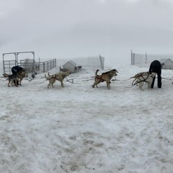
Alaska Mushing School
15 reviews
Phillips Cruises & Tours
88 reviews
Alpine Air Alaska
82 reviews
Girdwood Mushing Company
15 reviews
Paddlers' Realm
6 reviews
Sound Paddler
3 reviews
Portage Glacier Cruise
34 reviews
Arctic Valley Ski Area
14 reviews