Indianhouse Mountain Photos


You might also consider
More like Indianhouse Mountain
Recommended Reviews - Indianhouse Mountain
Start your review...

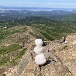
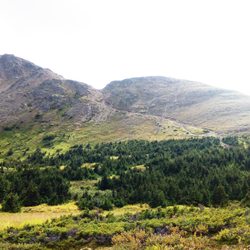
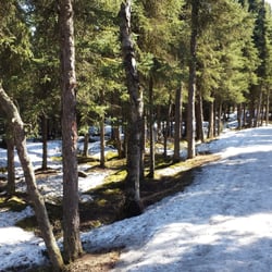
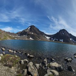
You may not know the name of this mountain but, she knows you... if you've driven through the Arm more than a couple times, you've definitely seen it. If you're driving back into Anchorage, it's visible as you're approaching the small village of "Indian" (home to one of the best restaurants in the state: Froth & Forage, https://www.yelp.com/biz/froth-and-forage-coffeehouse-and-eatery-anchorage) It's flanked by two official trails: Falls Creek Trail: on the "Anchorage side" (west) https://www.yelp.com/biz/falls-creek-trail-anchorage Indian Valley Trail: on the "Indian, AK side" (east) https://www.yelp.com/biz/indian-valley-trail-anchorage The trail that goes up to Indianhouse is not an "official trail". Because of this, I was always leery about climbing Indianhouse Mountain. I'm not super-thrilled about bushwhacking, and I thought getting to the mountain proper would require a ton of it. Oh, how wrong I was! The trail that goes up here is actually shockingly well maintained. No 'schwacking at all! It is, however, incredibly steep. Probably steepest trail I've been on in the Chugach State Park area (maybe that's why it's not "official"). Anyway, for the first (steep) mile, it's a very steep hike. You'll eventually top out on nice, wide prairie-like area. From here, casual hikers should probably turn around. You'll know you're at the turnaround point because the trail will start to become faint and eventually disappear into a ridge that leads to the much larger ridge of Indianhouse Mountain. To summit Indianhouse, DO NOT ride this ridge up to ridge of Indianhouse and then try to take that to the summit! This is a tempting move to make but the rock that lies ahead for you is of very poor quality and the moves are very much 5th-class! (e.g. you'll need a rope) Go partially up the ridge, but, before you connect with the summit ridge traverse right. And keep traversing right. This...can be kinda bushwhacky, but you're largely on tundra (and/or garbage snow). I'd say this is probably the crux of the hike/climb. You're looking for a large couloir (narrow gully) that leads up to the summit. It usually has snow in it until later in the summer. You might want to bring an ice axe and crampons or, at the very least, a trekking pole and some microspikes. The summit is exposed and complex, with incredible views in all directions. Views of the nearby Suicide Peaks are one-of-a-kind! read more


More info about Indianhouse Mountain


Indianhouse Mountain - hiking - Updated July 2026
Best of Anchorage
People found Indianhouse Mountain by searching for…
Waterfall in Anchorage, Alaska
Scenic Overlook in Anchorage, Alaska
Picnic Areas in Anchorage, Alaska
Scenic View in Anchorage, Alaska
Gold Panning in Anchorage, Alaska
Attractions in Anchorage, Alaska
Indoor Rock Climbing in Anchorage, Alaska
Photo Spots in Anchorage, Alaska
Hiking Trails in Anchorage, Alaska
Climbing Gym in Anchorage, Alaska
Tent Camping in Anchorage, Alaska
Things to Do in Anchorage, Alaska
View Points in Anchorage, Alaska
Playgrounds in Anchorage, Alaska
Hiking With Kids in Anchorage, Alaska
Dog Friendly Trails in Anchorage, Alaska
Waterfall Hike in Anchorage, Alaska
Watch Sunset in Anchorage, Alaska
Binoculars in Anchorage, Alaska
Browse Nearby
Browse Brands
Trending Searches in Anchorage, AK
Boat Rental near Indianhouse Mountain
Dog Friendly Trails near Indianhouse Mountain
Dog Swimming near Indianhouse Mountain
Fishing Spots near Indianhouse Mountain
Kayak Rental near Indianhouse Mountain
Lakes near Indianhouse Mountain
Off Road Trails near Indianhouse Mountain
Outdoor Activities near Indianhouse Mountain
Public Shower near Indianhouse Mountain
Rock Quarry near Indianhouse Mountain
Running Trails near Indianhouse Mountain
Scenic Overlook near Indianhouse Mountain
Soccer Store near Indianhouse Mountain
Sunrise View near Indianhouse Mountain
Swimming Holes near Indianhouse Mountain
Swimming Lakes near Indianhouse Mountain