Admiralty Point Photos


More like Admiralty Point
Recommended Reviews - Admiralty Point
Start your review...

3 years ago
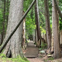
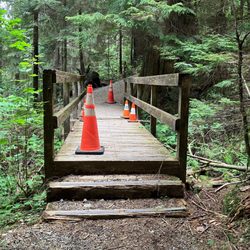
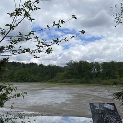
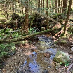
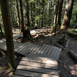
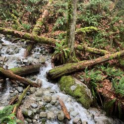
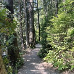
We came here for a late morning hike and the parking lot got full by the time we finished our hike around noon. Come early to avoid the crowd. That parking lot by the picnic area was close to the waterfront. Lovely view of the inlet and Deep Cove area. The trail is relatively easy with some rocky terrain. Just go slow if you have mobility issues. There are trees and some areas have railing to hold on to. It will take around 90 mins or so to do a round trip if you go at a slower pace. Nice place for a picnic and short hike. read more


5 years ago
Located in Belcarra Regional Park, Admiralty Point is a hiking trail going in the opposite direction of the Jug Island trail. It's between 5 and 6km round trip (every source has conflicting information), and the quoted time is 1.5 hours, although if you take your time (as we did), you can stretch it out to about 2.5 hours. The trail is classified as easy with minimal elevation, and while it is a fairly easy trail and is good for beginners and families, there are some steep areas and some rocks and tree roots to navigate, so it is a bit challenging for people with mobility issues (as was the case for one person in our group). I've done Jug Island a few times, but last month was my first time hiking Admiralty Point. (While you can hike both Jug Island and Admiralty point in the same day to make for one moderate hike, something I'd like to do, I have yet to have the opportunity due to various circumstances.) Most of the trail was covered in tree canopy (which was a necessity, given how hot the day was), and there were several paths leading to lookout points (a nice alternative to the busy Quarry Rock), as well as a small rocky beach (Maple Beach). We also walked the extra kilometer or so past Admiralty Point to Burns Point, which had the steeper and more challenging terrain. Overall, an easier hike that is perfect for beginners, although it may be challenging for people with mobility issues. I hope to make it out to Admiralty Point again and hike both Admiralty Point and Jug Island in one go to make for a longer hike. [Yelp collections: Hiking] read more


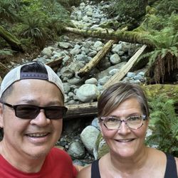
Has it already been five years since I traversed this trail with the family?! It's time we did it again. A family-friendly and relatively short hike at 5kms roundtrip with views of the surrounding mountains and Deep Cove. Keep an eye on the shoreline as you might encounter jellyfish like we did as you bob between the trees and under the tree top canopies. I much preferred this trail over Quarry Rock which is much too crowded. At the end of the trail, you'll be offered views of Burrard Inlet and if you're as lucky as we were (and the seagulls), a ton of starfish. read more


More info about Admiralty Point


Admiralty Point - hiking - Updated July 2026
People found Admiralty Point by searching for…
Hiking Trails With Waterfalls in Belcarra, BC
Lookout Points in Belcarra, BC
Picnic Areas BBQ Pits in Belcarra, BC
Swimming Lakes in Belcarra, BC
Beach BBQ Pits in Belcarra, BC
Secluded Spots in Belcarra, BC
Off Leash Dog Hikes in Belcarra, BC
Scenic Night View in Belcarra, BC
Walking Trails in Belcarra, BC
Redwood Forest in Belcarra, BC
Off Road Trails in Belcarra, BC
Running Trails in Belcarra, BC
Browse Articles
Browse Brands
Related Searches in Belcarra, BC
Affordable Kayak Rental Services in Belcarra, British Columbia
Best Fishing Locations and Guides in Belcarra, British Columbia
Discover Dog Friendly Beaches Near Belcarra, British Columbia
Discover Top Boat Tours in Belcarra, British Columbia for All Ages
Discover the Best Beaches in Belcarra, British Columbia
Enjoy Kayaking Adventures in Belcarra, British Columbia
Explore Beautiful Parks and Green Spaces in Belcarra, British Columbia
Explore Bike Rentals Throughout Belcarra, British Columbia
Explore Popular Boat Charters Near Belcarra, British Columbia
Explore Popular Campgrounds Near Belcarra, British Columbia
Explore Popular RV Parks Around Belcarra, British Columbia
Explore Scenic Lakes to Visit in Belcarra, British Columbia
Explore Summer Camps for All Ages in Belcarra, British Columbia
Explore Top Dog Parks in Belcarra, British Columbia Near You
Explore Whale Watching Tours in Belcarra, British Columbia
Explore the Best Boating Spots in Belcarra, British Columbia
Find the Best Playgrounds to Visit in Belcarra, British Columbia
Find the Best Swimming Pools in Belcarra, British Columbia Today
Hiking Trails With Waterfalls in Belcarra, British Columbia
Popular Fishing Spots to Explore in Belcarra, British Columbia
Popular Kids Activities in Belcarra, British Columbia
Popular Picnic Spots to Visit in Belcarra, British Columbia
Popular Things to Do in Belcarra, British Columbia
See Top Fireworks Events in Belcarra, British Columbia
Visit Popular BBQ Park Locations in Belcarra, British Columbia