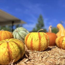
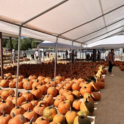
Acton Park Photos
You might also consider
Recommended Reviews - Acton Park


More info about Acton Park
You might also consider


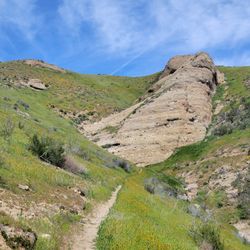

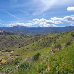


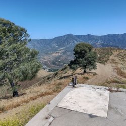

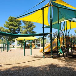
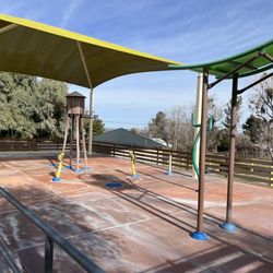


Acton Park - parks - Updated July 2026
Best of Acton
People found Acton Park by searching for…
Swimming Lakes in Acton, California
Hiking Trails With Waterfalls in Acton, California
Fishing Spots in Acton, California
Running Tracks Open to the Public in Acton, California
Places to Take Pictures in Acton, California
View Points in Acton, California
Beautiful Views in Acton, California
River Swimming in Acton, California
Playgrounds in Acton, California
Scenic Drive in Acton, California
Lakes & Ponds in Acton, California
Indoor Basketball Court in Acton, California
Walking Trails in Acton, California
Running Trails in Acton, California
Dog Friendly Places in Acton, California
Volleyball Courts in Acton, California
Baseball Fields in Acton, California
Picnic Areas in Acton, California
Scenic Night View in Acton, California
Parks and Recreation in Acton, California
Things to Do in Acton, California
Trending Searches in Acton, CA
4th Of July Fireworks in Acton, CA
Black Owned Nail Salons in Acton, CA
Dog Friendly Beaches in Acton, CA
Free Picnic Areas in Acton, CA
Kids Activities Outdoor in Acton, CA
Outdoor Basketball Courts in Acton, CA
Places To Walk Around in Acton, CA
Strawberry Picking in Acton, CA
Browse Articles
Browse Nearby
BEST of Acton, California Restaurants near Acton Park
BEST of Acton, California Playgrounds near Acton Park
BEST of Acton, California Coffee near Acton Park
BEST of Acton, California Things to Do near Acton Park
BEST of Acton, California Hiking near Acton Park
BEST of Acton, California Breakfast near Acton Park
BEST of Acton, California Star Gazing near Acton Park
Browse Brands
Related Searches in Acton, CA
Best Nature Trails for Hiking in Acton, California
Best Off Leash Dog Parks in Acton, California
Best Parks for Parties and Events in Acton, California
Best Water Parks for Kids in Acton, California
Check Out Great Playgrounds in Acton, California
Discover Baseball Fields Around Acton, California
Discover Beautiful Garden Spots in Acton, California
Discover Fun Toddler Parks in Acton, California for Your Little One
Discover Lakes & Ponds to Explore in Acton, California
Discover Outdoor Playgrounds for Kids in Acton, California
Discover Popular Photo Spots in Acton, California
Discover Soccer Fields in Acton, California Near You
Discover Top Nature Parks to Visit in Acton, California
Discover Top State Parks to Visit in Acton, California
Discover Walking Parks in Acton, California Near You
Discover the Best Beaches in Acton, California
Discover the Best Kids Park Spots in Acton, California
Enjoy the Best Picnic Spots and Ideas in Acton, California
Enjoy the Best Walking Trails in Acton, California
Explore Easy Hikes Perfect for All in Acton, California
Explore Family-Friendly Zoos and Wildlife in Acton, California
Explore Free Picnic Areas Around Acton, California
Explore Parks With Pull Up Bars in Acton, California
Explore Popular Campgrounds Near Acton, California
Explore Popular Picnic Areas Around Acton, California
Explore Popular RV Parks Around Acton, California
Explore Popular Recreation Centers Around Acton, California
Explore Popular Scenic Views Near Acton, California
Explore Scenic Lakes to Visit in Acton, California
Explore Top Dog Parks in Acton, California Near You
Explore Top Water Parks in Acton, California Today
Explore the Best Trail Options in Acton, California
Find Parks and Recreation Activities in Acton, California
Find Top Dog Friendly Parks to Visit in Acton, California
Find Top Skate Parks in Acton, California for All Skill Levels
Find a Park With BBQ Pits in Acton, California
Find the Best Parks BBQ Grills in Acton, California
Find the Best Parks for Picnics in Acton, California
Have Fun at a Splash Pad in Acton, California
Locate Tennis Courts Around Acton, California
Parks With Basketball Courts for Games in Acton, California
Picnic Areas With BBQ Pits Available in Acton, California
Play at a Splash Pad Park in Acton, California
Popular Children Playgrounds to Visit in Acton, California
Popular Places to Take Pictures in Acton, California
Top Hiking Trails to Explore in Acton, California
Top Running Trails to Explore in Acton, California
Top Swimming Lakes to Enjoy in Acton, California