Cancel

    Open app

    Search

    大東山

    Sunset Peak

    4.8 (4 reviews)
    Open Open 24 hours

    大東山 Photos

    Recommended Reviews - 大東山

    Your trust is our priority, so businesses can't pay to alter or remove their reviews. Learn more about reviews.
    Yelp app icon
    Browse more easily on the app
    Review Feed Illustration

    8 years ago

    Helpful 1
    Thanks 0
    Love this 1
    Oh no 0

    10 years ago

    Helpful 0
    Thanks 0
    Love this 1
    Oh no 0

    大東山 Reviews in Other Languages

    Verify this business for free

    Get access to customer & competitor insights.

    Verify this business

    天池

    天池

    4.3(4 reviews)
    10.2 kmLantau Island

    This spot has to be one of the best oasis in Hong Kong...I had planned to go to Tai Long Wan with a…read morefriend who was visiting me but we made a last minute change of plans and decided to go to the pool. We still needed to pack food and water and wake up early anyway. We started our trip in Wan Chai and took the MTR to Tung Chung and then bus 11 to Tai O. That was all pretty smooth and as we got to Tai O village, we strolled around for a few minutes and got on our way quickly after buying some water. The hike to the pool is moderate difficulty wise but the humidity made it a little harder than expected (and the view of the infinite...flight of stairs) but it's enjoyable: the views are pretty amazing and it's peaceful. When the level of sweatness was reaching its peak (or an hour into our hike) we could hear the waterfall...! And finally, the pool! We spent a good four hours there, swimming, chatting, meeting new people, climbing. We also had our lunch sitting on the rocks and overlooking the landscape. It couldn't get any better! Be warned that there's no food or water available once you leave Tai O, so make sure you bring enough of those. As we were leaving, the sun, who had left us for a few minutes, came back! So we had yet another bath. This was around 5pm and although some people had already left, the pool was still busy. A note on that: the earlier you get there, the better, as the ground is all made of rocks and it's uneven and you may want to find a nice spot to eat and rest. It's a really cool place to go on a sunny day. Easy to reach but far away enough so that it's not overcrowded. I hope it stays that way. Now next stop Tai Long Wan!

    I think I was the last one in Hong Kong to hear about this infinity pool. I'd hear tourist talking…read moreabout an infinity pool in Tai O on the Mui Wo ferry and I'd think, you've got it wrong, the Four Seasons is in Central! I got it wrong. I may be a little harsh with my rating of the pool mainly because I've seen some awesome waterfalls around the world (not trying to boast). For Hong Kong this place is amazing, were it not for the huge influx of visitors it'd be the first place on my list to bring friends visiting HK. The hike to the pool is not so bad. It would be better were it not for the fact I got lost and added another 30 minutes to it. 30 additional minutes of dodging spiders the size of my face is not fun, trust me. Be sure to google the directions first! The only challenging part being the stairs. It's great though (think positive!) because after feeling exhausted and on the brink of heat stroke there's a cold, freshwater pool waiting for you to collapse into. The pool itself is a decent size with enough rocks nearby to have a little picnic, soak up the sun and dangle your legs in the water. It also has a gorgeous view overlooking mountains and the sea. Behind the pool is a mini rock-pools under a giant waterfall, which is just as much an attraction as the infinity pool in my opinion. I spent much of my time getting a free massage from the cascading water. The hike back was much easier, and being later in the afternoon most of the spiders were gone. All in all I would highly recommend the place to any one. If you can avoid going on a weekend then do so and save it for a weekday. I went on a Monday and it was too full for my liking so I can't imagine what it would be like on a day off!

    Photos
    天池
    天池
    天池

    See all

    鳳凰山

    鳳凰山

    5.0(6 reviews)
    3.7 kmLantau Island

    Lantau Peak (aka Phoenix Peak) is the 2nd highest peak in HK at 934m, but it is the highest peak…read moreyou are able to directly access (the highest peak's terminus is otherwise on private property). There are various routes to reach the summit. We sought out Middle Dogs Teeth/ Kau Nga Ling for our ascent. The trailhead for this ridge trail begins just before Shek Pik Reservoir. There's a bus stop that goes to the reservoir, but we took a blue taxi from Tung Chung MTR Station for a faster, more direct service (~160 HKD). The trail is very well known and the uncle who drove us knew exactly where to take us when we said we wanted to go up Lantau Peak near the trailhead close to Shek Pik. He called the dogs teeth "crazy" - BAH! The trailhead was situated in a park where a bunch of happy cows roamed. It also had a super clutch and rather clean port-a-potty for getting the morning biz-ness taken care of before the AWESOME, on-all-fours, class 3 straight scramble up to Lantau Peak. Trail starts off pretty straight forward until you reach an off shoot leading into dense foliage and with a sign warning you not to proceed any further (due to a previous fatal accident). Which everyone ignored, of course, including the senior-aged uncles and aunties which was a signal to us of permission granted (because being led by example and all :)). We did a point-to-point from the trailhead near Shek Pik to Ngong Ping Village with the intention of taking the 360 cable car down. I tracked it at around 4mi/ 6km with 3,000 FG/ 970m. It took us about 3 hours to get to the top of Lantau with many breaks and chats with all the uncles and aunties along the way. The most dangerous section is what has been lovingly deemed the Lifeline, or One Line of Survivability. This section encircled a rocky mound which was passable only in one direction. There was a chain bolted into the rock which served as a hand hold when traversing the narrow section with a sheer drop on the other side. Honestly, I've seen scarier, but the riskiness is there especially for someone with a fear of heights, I am sure. It is still cause for a fun celebration when you successfully "survive" it. Loved the view as we made the final push up the Phoenix's "tail". It was foggy at the top, but the fog was very welcomed on this mostly exposed trail. The temperature was perfect and although a lot of work, it wasn't terrible, in the end. We doubled back to the junction just before the Phoenix's tail to descend to the Tian Tan Big Buddha, but one of the aunties was saying how we could have continued on past the peak to another trail which also descended to Tian Tan Village. Such a gratifying hike with phenomenal views at the top in what is suppose to be a 360 degree view of Lantau Island. We otherwise had fog which mattered not since the whole point-to-point journey eventually granted us views of all parts of Lautau. The decision to climb up Lantau depends on time and your energy because the ascent up Middle Dogs Teeth is one of the hardest hikes in HK. There are easier approaches via Pak Kung Au and even from Tian Tan Village itself. Regardless, seeing Lantau Island from the perspective of the peak is not be missed!

    When I first walked up to the sign that said, Lantau Peak 3.5km ~2.5hr I was flabbergasted. I'm no…read moreexpert hiker, but I can definitely hike 3.5km faster than that! I dragged my mom on the paved path cheerfully preparing for our journey up the mountain. When we hit the first set of stairs, I was like hey! We got this! It'll level out soon... nope. This hike is actually just under 2km of straight stone steps. Imagine a never ending stairmaster! The hike is challenging, but never too dangerous. There are some great clear lookout spots (aka resting points) of the Buddha. The last .5km may seem like a stretch but definitely worth it. There is railing in some spots but I never felt like I was going to fall off the mountain or anything. I was pretty disappointed in the overcast skies but still a beautiful view. This is a must do hike! Take lots of breaks on both the incline and decline since the stairs are just as hard coming down. We came to the trail head by way of the 23 bus at the end of the orange line on the MTR. You can also see the Buddha while you're at it. Alternatives are to take the gondola up, or hike the Lantau Trail but I'm not 100% sure where that starts.

    Photos
    鳳凰山
    鳳凰山 - The Lifeline

    The Lifeline

    鳳凰山

    See all

    下白泥 - Yuen Long MTR B, Minibus 33, Duck Pit

    下白泥

    4.4(7 reviews)
    17.7 kmLau Fau Shan, Yuen Long, New Territories

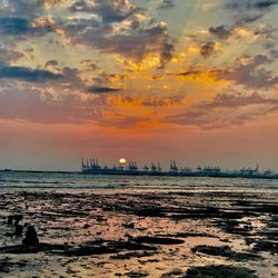
    Ha Pak Nai is a subdivision of Pak Nai ( Ha means 'lower'). It is a coastal area in the…read morenorthwestern area of New Territories, and faces the Deep Bay. Partly a shallow pebbly beach and partly a wetland mangrove, it is listed as a Site of Special Scientific Interest in Hong Kong. Besides driving (actually the parking space is kind of limited due to the rush of people at weekends days of good weather), you can also get there by taking minibus route no. 33 at Tai Fung Street at Yuen Long town center, not far from Yeun Long or Long Ping MTR station, and get off after Lau Fau Shan roundabout. Some friends also opted for biking there but it's not an easy route, so only for people with confidence with biking skills. Because of its vantage location along the western coast, it is one of the best places in Hong Kong to view the sunset, unobstructed by buildings in front and overlooks onto the Shekou area of China on the far far horizon. The scene is quiet and open, and the sky stretches to infinity. It is even more serene if there is a bit of cloud in the sky, with the rays of golden lights refracted over the brim of the clouds forming layers of golden cotton candies . Quite a romantic view for couples indeed! On the pebbly beach you can often some fisherman's raising nurseries for seafood and also oysters raised on pieces of concrete blocks. Additionally, it is also very close to Lau Fau Shan, a popular place from Chinese-style fresh seafood in HK for reasonable price, so it is a very common itinerary for the locals to go for the sunset view at Ha Pak Nai and then have a seafood feast over at there.

    For a long time this was a hidden secret for those who knew their way amongst the back end of Yuen…read moreLong and Tin Shui Wai; this was the border and unless you lived here or worked here; no one would venture this far. The reasons were clear: there is a track that ran along the seaside with pretty much nothing to do- moreover at night this was a good location for IIs to come ashore so it wasn't the sort of place you would like to hang around. Times have changed though. Shenzhen has become more prosperous and there's more to look at on the opposite side of the shore than there is on this side. After the SARS event Hong Kongers have taken to the countryside which is decidedly a good thing as we now fully appreciate our natural beauty spots; which includes deep bay. This used to be a fishing village where oyster farms were abundant (water quality: not too sure) and most people came to Lau Fau Shan for the famed seafood and the local produce: salted fish and various dried fishery items. These are all still here but I guess the grips of commercialism has hit and it has lost the quiet ambience some what, with cars clogging up the route up here every weekend. Still though, if you venture down the path down deep bay towards the new Western Crossing, you will still find the mud banks which it is famed for. At low tide the mud banks are exposed and you will find all sorts of wild life here: crabs, birds and the sunset view is simply second to none. Cyclist will enjoy the fact that the further you go the less cars there are so they are free to roam this area. There's not much in terms of attractions here but that is in itself the beauty of it.

    Photos
    下白泥
    下白泥
    下白泥

    See all

    Ngong Ping - Tung Chung Hike

    Ngong Ping - Tung Chung Hike

    4.0(1 review)
    2.2 kmLantau Island, Tung Chung

    I've done this hike about 4 times - all in the space of a week. Not by choice, mind you, I was…read morehired to take photos of the Buddha, cable cars, and general area along the trail. I was walking with an extra ten kilos on my back, and suffering from minor food poisoning that effected the overall experience, but I still had a great time strangely enough. I started the hike at Ngong ping for one main reason. It meant as soon as I finished the hike I didn't need to wait for an hour or whatever it is for the bus to get back to Tung Chung. The trail begins fairly easily, flat or with a gradual incline. It goes on like this for about twenty minutes until you reach the stairs. Dam those stairs, and these are not even the bad stairs. A steep section of stairs lead to probably the highest point of the trail. All the while the cable cars are traveling overhead with people watching, and probably laughing at your struggles. At the top of this hill you're left with a glorious few of both sides, Ngong Ping, Tung Chung and also the Airport. From here I went off the trail a bit to get an even better view. It only took five minutes but it was well worth the effort. After snapping a few pics I continued along the trail... this is where the hell stairs begin. The mountains are structured like a twin camel's humps meaning you need to go down a long way then up again, then down and up and then finally down! most of this is done on a steep staircase. Let me tell you, the next day your legs will be stiff as wooden boards! The entire hike takes between 1,5 to 2 hours. It's a great trail for beginners wishing to push themselves a little and provides more than one place worth stopping at for the all-important selfie. Be sure to bring water and mosquito repellant!

    大嶼山 - Po Lin Monastery to the right

    大嶼山

    4.5(10 reviews)
    1.3 kmLantau Island, Tung Chung

    I visited Lantau Island last year with my hb…read more Lantau Island is famous for the Tian Tan Buddha, the Po Lin Monastery, the Hong Kong Disneyland, Ngong Ping 360 cable car. And lessor known areas that our driver pointed out to us in a distance, Shek Pik Prison, a prison for mid to long term sentences and for life imprisonments. And other corrections facilities that we didn't see, but on the island. On Lantau Island, you feel the remoteness away from the hustle and bustle of the Hong Kong metropolis. It used to be completely farm country until it became touristy with the erecting of the Buddha and Disneyland. On our drive, we saw some water buffaloes (similar to the carabao in the Philippines, maybe same species) on the winding roadways that I thought were statues because they were just so still. Sitting or standing. But our driver told me that years ago when the government wanted to develop part of the land, a lot of farmers (landowners) let their water buffaloes roam free and become wild instead of killing them, so today, they inhabit the island. I absolutely love it and wouldn't mind coming back to explore again when pandemic is over.

    Great day trip to Lantau Island. We taxi (MTR was closed) so…read morecant give you advice on that. Ngong Ping gondola ride is a must. Purchase the crystal (glass) one if you're not afraid of heights---you can see below to the green trees and ocean. BUy your ticket off Klook for a discounted price. Walk up the 298 steps the to Tian Tan---big Buddha! Walk around Lo Pin Monastery. Take a short 10 min bus ride to Tai O Village and Market to see the houses on stilts and try their famous shrimp paste flavored food!

    Photos
    大嶼山 - 268 Steps Up to the Big Buddha

    268 Steps Up to the Big Buddha

    大嶼山 - Finally got to climb up to the Big Buddha

    Finally got to climb up to the Big Buddha

    大嶼山

    See all

    Mui Wo Waterfalls

    Mui Wo Waterfalls

    3.0(1 review)
    0.5 kmLantau Island

    "There is a lot of fun to be had when walking surrounded by nature's beauty." Said no one ever that…read morehiked in Hong Kong during the summer! Yet people still do it... I did it, don't as me why. Perhaps it had something to do with exploring the island I now resided on. Anyway, the hike I chose, a short one, led to not so secret waterfalls in Mui Wo. I say not so secret because there is another waterfall, further up the path that is called the secret waterfalls - we didn't make it that far. My friend I and started our journey at 9:30am. Error number one. We thought it would be cooler, and so it was, barely, but what we didn't plan for were the spiders that looked like they walked out of an Aliens movie. Some where as big as my hand, without exaggerating, and there were hundreds of them, without exaggerating once again. We were on the constant look out for the creepy crawlies, walking like dumb and dumber with sticks in our hands. There were times when we had to hunch over and pray while walking. So after making a twenty minute walk last forty minutes we finally made it to the waterfall. It has a small changing room and toilet nearby, and a pagoda for shade. We changed into our swimmers and walked in... except there wasn't really anywhere to swim. There are a few pools big enough to host a trio of people but no where to frolic. Anyway we cooled ourselves of in one of the pools and enjoyed the vision of the waterfall for about an hour. After the hour we explored the falls a bit, stood under the cascading water and forgot about the spiders. Apart from the waterfalls themselves there is a winding, shallow river that heads back to the beach, which I'd like to walk down one day. It turned out to be a fun, short hike, and we managed to build up an appetite for lunch.

    大東山 - hiking - Updated August 2026

    Loading...
    Loading...
    Loading...