Cancel

    Open app

    Search

    White Clay Creek Preserve

    5.0 (1 review)

    White Clay Creek Preserve Photos

    You might also consider

    Recommended Reviews - White Clay Creek Preserve

    Your trust is our priority, so businesses can't pay to alter or remove their reviews. Learn more about reviews.
    Yelp app icon
    Browse more easily on the app
    Review Feed Illustration

    3 years ago

    Helpful 0
    Thanks 0
    Love this 0
    Oh no 0

    Verify this business for free

    People searched for Hiking 484 times last month within 15 miles of this business.

    Verify this business

    The Serpentine Barrens - geological wonderland; basically a 'desert' region in SouthEast PA

    The Serpentine Barrens

    4.0(2 reviews)
    16.7 mi

    Half decent scenic route. 4/10 in terms of difficulty-…read moretrail is pretty good workout for uphill and downhill 2/10 for trail management. The trails at certain points were extremely overgrown and poorly marked. Lucky there is cell reception and I could use it to navigate correctly. But certain areas are way too overgrown resulting prime tick habitats to the point where certain grass areas I can physically SEE ticks sitting on grass overlapping the trail.

    Here's the official description: "Located along a 20-mile stretch of the Maryland-Pennsylvania…read moreborder, the State Line Serpentine Barrens, the largest occurrence of Serpentine Barrens in the eastern United States, contains some of the last major remnants of serpentine grassland and savanna in eastern North America. " But what this means to you and me is that its just a fantastic; eerie; unearthly natural environment to go seek out and hike in. Of especial interest to horticulturalists and wildlife biologists; students; geologists, arborists, sylviculturalists, ecologists--sure. It is all that. But just in general --a fun and free place to roam around if you're simply an outdoors enthusiast. There is no one here; its deserted; and filled with all sorts of strange trees, shrubs, flowers, grasses, and lichens. You can really get your nature on; a really 1-on-1 experience.

    Photos
    The Serpentine Barrens - Everything growing here is stunted in height to approx 3/4 scale

    Everything growing here is stunted in height to approx 3/4 scale

    The Serpentine Barrens - The State Line Serpentine Barrens -- from one of their websites

    The State Line Serpentine Barrens -- from one of their websites

    The Serpentine Barrens - May not immediately be apparent to the naked eye but all the vegetation is geared for arid desert conditions

    See all

    May not immediately be apparent to the naked eye but all the vegetation is geared for arid desert conditions

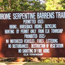
    Chrome Serpentine Barrens - Chrome Serpentine Barrens -- closings notice

    Chrome Serpentine Barrens

    4.0(1 review)
    9.1 mi

    VALUABLE LESSON: Never make assumptions! Always do your research, ask questions, make contact, do…read morethe work to find out what's up! (more on this below) I was FASCINATED to explore the various State-Line Serpentine Barrens in Southeastern PA. This is a rare area of genuine savanna habitat, right here in Penna! This habitat came about b/c Native Americans used fires to clear vegetation, so that only grass would grow, which would attract grazing animals to hunt. They practiced this fire setting from NY to MD & on down to AL. With nothing to retain moisture, a savanna habitat formed & Cactaceae vegetation grew. When Europeans settled the area, the desert was cultivated for farm & settlement use, so the habitat changed once again. The few areas of serpentine barrens that remain (60 sq mi), have been protected by The Nature Conservancy since 1979. They maintain the land with controlled fires, just as Native Americans did. Thin soil lies on a bedrock of serpentine stone (light-green in tone). It has high levels of nickel, chromium, etc. that are toxic to most plants/animals. Living here, are rare & endangered species, that evolved over thousands of years in adaptation to the unique habitat. The serpentine aster here does not exist anywhere else in the world. Other rare plants are: the round-leaved fameflower, & hairy chickweed. The serpentine barren ecosystem relies on periodic fire to destroy forest & certain plants that begin to invade. Fire opens the land to prairie grasses, wildflower meadows, pitch pines, & diverse types of ferns. This attracts a number of moths & butterflies (cobsew skipper, red-banded hairstreak, mottled duskywing, barrens buckmoth & dusted skipper), as well as birds (barred owl, declining whippoorwill, several warblers, bobwhite quail, etc.). There are various pockets of serpentine barrens in the SE PA area, but not all are public. Also, each site has different hours / accessibility requirements, but among the public ones, there is access for hiking, horseback riding, & bird watching. - Goat Hill (602 acres co-owned with Pennsylvania's Bureau of Forestry) - Chrome (390 acres co-owned with Elk Township) - Nottingham (630 acres owned by Chester County) - Rock Springs (170 acres owned by Lancaster County Conservancy and private owner) - Texas (210 acres privately owned) - Pilot (92 acres co-owned with a private owner) Chrome looked the most promising public option from what I read on the Nature Conservancy website. I did contact another Yelper who had reviewed another barren, but he was unsure where to go b/c he visited through his U-Penn Geology Grad program. So I planned for Chrome, expecting to have to hike a ways to get to a savanna clearing, but that it would be pretty straightforward. Why it's important to COMMUNICATE: First, it is easy to drive past the trail b/c there is no street signage. (I posted a pic of the entrance to help others.) Gravel lot, not super big. It's very wooded all over. There was no trail map, just a sign stating you were at the Chrome Serpentine Barrens. The trails were marked clearly, but were a mix of dirt & grass (up to 10" high) that needed mowing. The area, ironically, was extremely wet / muddy, with mosquitoes so bad I could barely keep my eyes open. I had my son on my back, & he suffered the bugs as well. We hiked for 15 minutes down the most promising trail, but came nowhere near a clearing. I was expecting to rise a little in elevation to escape the stagnate puddles & mud, but that didn't happen. I studied the tree canopy for clearings, but the canopy, & ground-level visibility gave no hint of a clearing anywhere along the approx 0.6mi I hiked into this barren. Unfortunately, the bugs were just too prolific to bear, so we retreated & left. I always give trails or greenspaces at least 4 stars on Yelp, so I will do the same for this place, however, MUCH better communication is needed to disclose what is going on here. Where are these charming plains with frolicking birds & Cactaceae? If they're a 2mi hike in, could someone explain that? Could you show me which trail will lead me there? I made wrong assumptions about the info that would be presented at the trailhead, & about the feel of the trails themselves. I definitely need to contact The Nature Conservancy directly, & I will shoot an email to an admin at Penn's Geo program as well. I'll update if/when I have more info. For now, if you're headed there, be prepared to SLATHER yourself in bug repellent, wear high socks to guard against ticks on the unmowed trail, hiking boots to wade through mud, stamina to hike a while, & low expectations, b/c it's very unclear where/when you will ever discover these elusive mythical plains! I have a feeling that if I had communicated with people in the know, I'd have been led to AMAZING sights, like the pics the other Yelper took, instead of fumbling around in the miserable haze of mosquitoes & mud, only to reatreat home, unsatisfied, & annoyed!

    Photos
    Chrome Serpentine Barrens - Chrome Serpentine Barrens -- trails well marked, just no map of the park to show where you're going, or distance!

    Chrome Serpentine Barrens -- trails well marked, just no map of the park to show where you're going, or distance!

    Chrome Serpentine Barrens - Chrome Serpentine Barrens -- lots of mud and mosquitoes (be prepared)

    Chrome Serpentine Barrens -- lots of mud and mosquitoes (be prepared)

    Chrome Serpentine Barrens - Chrome Serpentine Barrens -- sign INSIDE parking lot at trailhead

    See all

    Chrome Serpentine Barrens -- sign INSIDE parking lot at trailhead

    The Pinnacle

    The Pinnacle

    5.0(15 reviews)
    57.0 mi

    Came here on Sat 10/25 to hike with a couple gf's and brought my doggo, Linc, since it's a dog…read morefriendly trail. I work out but I wasn't ready for this trail as a first time hiker lol! I wore sneakers but would have greatly benefited from hiking boots for more ankle support after slipping and tripping my way along the dense leaf covered dirt trail that continued to get more rocky on the ascent. Also, you will need to climb some legit large rocks/boulders to reach the Pulpit Rock overlook but the challenge was well worth it for the views! My gf's & I chose the easy way down which was to take the gravel road alongside the observatory that eventually transitions to pavement. Even the decline of this road was steep in itself. No easy way up or down haha! I saw people of all ages and fitness levels along my hike and plenty of cute dogs! Bring snacks and water to re-energize during a rest break. My one friend packed some TP and I thought it was a great idea cuz you just never know when you might have to go! Parking lot is a joke with ~20-25 spots but many ppl, including us, parked along Reservoir Rd so make sure to get here early in the morning or expect to walk a couple extra miles just to reach the start of the trail.

    Great spot for a day hike, with beautiful views at the two main lookouts - Pulpit Rock and the…read morePinnacle. The hardest part of the hike is getting to Pulpit Rock, as it starts with a fairly steep road to get to the trail, and then some more elevation climb as you get up to the lookout. From there, it's probably another 2.5 miles or so to get to the Pinnacle, but the elevation gain is minimal. Both of these stops provide great views, with lots of raptors flying around if you're lucky! Bring snacks and water, especially on a hot day, and cameras to take pictures!

    Photos
    The Pinnacle - Jerico and myself on a pinnacle hiking adventure  Loving life and the gifts God provides

    Jerico and myself on a pinnacle hiking adventure Loving life and the gifts God provides

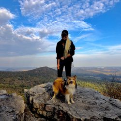
    The Pinnacle - Pulpit Rock overlook with my pup

    Pulpit Rock overlook with my pup

    The Pinnacle

    See all

    PPL Holtwood Environmental Preserve

    PPL Holtwood Environmental Preserve

    4.0(2 reviews)
    29.5 mi

    Wow, How do I review this... We wanted to go and hike around…read morepinnacle overlook, so we found some info and went. Boy some parts were great, others....well.. THE VIEW: Spectacular. At the peak, you can look out over a bend in the river and see the whole valley. Its really a cool summit. Its something that you need to see as there arent very many places like it in Lancaster county. HIKING: These are some of the poorest marked trails Ive ever been on. It would be pretty easy to get lost but they are well defined trails. They have 2 separate trails that have red marks, if you can find the mark that is, then you can guess at which one your on. They were faded, hidden behind a bush or non existent. And they have no starting point. Some places put up a sign. They could at least clearly mark a tree to show where it starts. Oh and the map! Talk about a doodling! The trails had forks that werent even on it. We just pick one and hoped for the best. The hike itself was nice tho. Anyway.... Id give it 1.5 stars for hiking trail issues. The view is pretty awesome tho. Check it out just for that!

    Wow, I visited here yesterday with a Meetup hiking group. This place was fantastic. There were…read moreseveral stream crossings since our leader took us off the beaten path a few times. Eventually, we followed the orange trail markers to the pinnacle. You will notice as well there is a parking area as well if you just want to drive up there. However, it's more satisfying trekking up to the top. The view is spectacular and you get a great view of the Susquehanna River. Plenty of wonderful boulders and small waterfalls to see here and photograph.

    Photos
    PPL Holtwood Environmental Preserve
    PPL Holtwood Environmental Preserve
    PPL Holtwood Environmental Preserve

    See all

    White Clay Creek Preserve - hiking - Updated May 2026

    Loading...
    Loading...
    Loading...