Weatogue Park Photos


You might also consider
More like Weatogue Park
Recommended Reviews - Weatogue Park
Start your review...

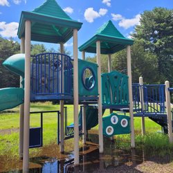
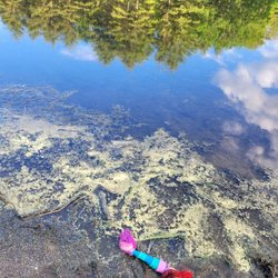
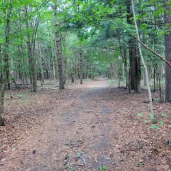
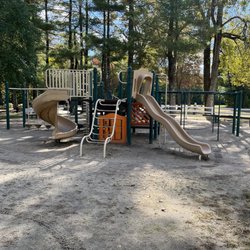
A nice open park with a softball field, football field, playground, and a brick building in the back. Based on Dan R.'s review, they do demo fires in that building for the firefighters to train with, cool! The next cool thing is, it connects to the Farmington Trail. This is a good spot to park your vehicle and go walking/biking on that trail. The playground was in good shape and it had swings, slides, ladders, etc. My toddler approves. I saw plenty of people walking their dogs. I did see dog poop near the softball field after my toddler stepped on it (Please clean up after your pets people). There were plenty of parking, bleachers, a bench, and a picnic table near the softball field. There were two benches near the playground. You can see the Hublein Tower from this park clear as day. Overall, a peaceful and lovely park that I discovered through Yelp; got to enjoy it on a warm (57 degrees) February day. read more


"Fightin' fire with fire 365 degrees Burning down the house" (The Talking Heads) You'll see many things within Weatogue Park's eight acres. Two soccer fields, a football field, softball field, a small playground, a stash of outdoor lighting fixtures for night games, and a cut-through to a very nice Rails to Trails path. But maybe the coolest thing of all is a masonry building behind the fire station. You see, it gets set on fire several times a year for Fire Department training. Now that's something you sure don't see very often. There was no fire going on today, but we did see a few families using the playgrounds for their little ones. Over the years, we've seen the sports fields busy with youth teams and adult softball games. There's also a very funny sign urging dog walkers to clean up their Poochie's mess because "there is no Poop Fairy". We used the park's cut through to access the Rails to Trails path and walked over to Deer Park Road and back. What a fantastic town park to enjoy! read more


More info about Weatogue Park
You might also consider


Weatogue Park - parks - Updated May 2026
Best of Weatogue
People found Weatogue Park by searching for…
Playgrounds in Weatogue, Connecticut
Soccer Fields in Weatogue, Connecticut
Walking Trails in Weatogue, Connecticut
Sporting Goods in Weatogue, Connecticut
Picnic Areas in Weatogue, Connecticut
Night View in Weatogue, Connecticut
Places to Take Pictures in Weatogue, Connecticut
Dog Swimming in Weatogue, Connecticut
Youth Soccer in Weatogue, Connecticut
Running Tracks Open to the Public in Weatogue, Connecticut
Scenic Drive in Weatogue, Connecticut
Photo Spots in Weatogue, Connecticut
Running Trails in Weatogue, Connecticut
Softball Fields in Weatogue, Connecticut
Toddler Playground in Weatogue, Connecticut
Playgrounds for Kids in Weatogue, Connecticut
Picnic Spots in Weatogue, Connecticut
Toddler Parks in Weatogue, Connecticut
Baseball Training in Weatogue, Connecticut
Hiking Trails in Weatogue, Connecticut
Things to Do in Weatogue, Connecticut
Fun Things to Do With Teens in Weatogue, Connecticut
Trending Searches in Weatogue, CT
Baseball Fields near Weatogue Park
Botanical Gardens near Weatogue Park
Bounce House Rentals near Weatogue Park
Campgrounds near Weatogue Park
Floral Designers near Weatogue Park
Flower Shop near Weatogue Park
Garden Center near Weatogue Park
Nurseries & Gardening near Weatogue Park
Outdoor Activities near Weatogue Park
Outdoor Furniture Stores near Weatogue Park
Party Equipment Rentals near Weatogue Park
Photo Spots near Weatogue Park
Picnic Areas near Weatogue Park
Playgrounds near Weatogue Park
Browse Articles
Browse Nearby
Browse Brands
Related Searches in Weatogue, CT
Best Day Camps for Children in Weatogue, Connecticut
Best Fishing Locations and Guides in Weatogue, Connecticut
Best Gymnastics for Kids Activities in Weatogue, Connecticut
Best Off Leash Dog Parks in Weatogue, Connecticut
Best Parks for Parties and Events in Weatogue, Connecticut
Best Soccer Park Locations in Weatogue, Connecticut
Best Softball Fields Available in Weatogue, Connecticut
Best Turf Fields for Sports and Events in Weatogue, Connecticut
Best Water Parks for Kids in Weatogue, Connecticut
Browse the Best Skate Shops in Weatogue, Connecticut Today
Buy Used Sports Equipment Near Weatogue, Connecticut
Check Out Great Playgrounds in Weatogue, Connecticut
Check Out Off Road Trails in Weatogue, Connecticut
Discover Kids Indoor Play Area Venues in Weatogue, Connecticut
Discover Popular Photo Spots in Weatogue, Connecticut
Discover Soccer Fields in Weatogue, Connecticut Near You
Discover Top Nature Parks to Visit in Weatogue, Connecticut
Discover the Best Beaches in Weatogue, Connecticut
Discover the Best Running Track in Weatogue, Connecticut
Enjoy Hiking Adventures in Weatogue, Connecticut
Enjoy Roller Skating Activities in Weatogue, Connecticut
Enjoy the Best Walking Trails in Weatogue, Connecticut
Experience Stunning Sunset Views in Weatogue, Connecticut
Explore Airsoft Games and Events Happening in Weatogue, Connecticut
Explore Beautiful Botanical Gardens in Weatogue, Connecticut
Explore Beautiful Parks and Green Spaces in Weatogue, Connecticut
Explore Family-Friendly Zoos and Wildlife in Weatogue, Connecticut
Explore Free Picnic Areas Around Weatogue, Connecticut
Explore Fun Activities to Do in Weatogue, Connecticut
Explore Kids Sports Programs and Leagues in Weatogue, Connecticut
Explore Landmarks & Historical Buildings in Weatogue, Connecticut
Explore Martial Arts Options in Weatogue, Connecticut
Explore Outdoor Basketball Courts for All Skill Levels in Weatogue, Connecticut
Explore Pickleball Courts in Weatogue, Connecticut
Explore Popular Campgrounds Near Weatogue, Connecticut
Explore Popular Picnic Areas Around Weatogue, Connecticut
Explore Popular Recreation Centers Around Weatogue, Connecticut
Explore Scenic Lakes to Visit in Weatogue, Connecticut
Explore Stadiums & Arenas Around Weatogue, Connecticut
Explore Summer Camps for All Ages in Weatogue, Connecticut
Explore Top Dog Parks in Weatogue, Connecticut Near You
Explore Top Gyms in Weatogue, Connecticut Now
Explore Top Water Parks in Weatogue, Connecticut Today
Explore Volleyball Courts Available in Weatogue, Connecticut
Explore the Best Rock Climbing Areas in Weatogue, Connecticut
Explore the Best Soccer Clubs in Weatogue, Connecticut
Find Batting Cages Near You in Weatogue, Connecticut
Find Indoor Basketball Courts in Weatogue, Connecticut
Find Parks and Recreation Activities in Weatogue, Connecticut
People who viewed Weatogue Park also viewed
Buckingham Park
3 reviews
Northwest Park
7 reviews
Granbrook Park
3 reviews
Simsbury Farms Playground
2 reviews
Rotary Park Boundless Playground
2 reviews
Eisenhower Park
1 review
Day Hill Dome
2 reviews
Walter's Boundless Playground
1 review
Ana Grace Marquez Greene
2 reviews
West End
Simsbury Farms Recreation Complex
5 reviews