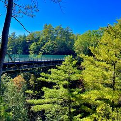
Warren Falls Photos


More like Warren Falls
Recommended Reviews - Warren Falls
Start your review...

Reviews With Photos

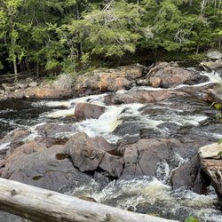
Warren Falls is a MUST - wow, absolutely breathtaking! At our stop in Moss Glen Falls, we met an avid traveler who visits the falls in Vermont each year. Without him, we wouldn't have known about this stop! Unlike some of the other falls we saw on this trip, Warren falls has a clearly marked parking lot. Once you park, you can start a semi-easy hike to the falls. I 100% recommend water shoes for this hike, as I think the best part is being able to enjoy the water once you hit the falls. The hike to the falls isn't hard, but it's a little narrow with a bit of up and down. Once you make it to the falls it is absolutely gorgeous. Crystal clear water - something straight out of a movie. Then, there are small cliffs where you can jump into the water. DO IT! I am the most scared and non-adventurous person ever, and I jumped right into the water and loved every second. We visited in late July and the water was FREEZING (granted, from Miami here but still). But regardless, it felt really nice to dive in and enjoy all that Warren Falls had to offer. Really fun activity, and something I won't soon forget. PS - use the bathroom before you arrive, I didn't spot any facilities as part of the park.


4 years ago
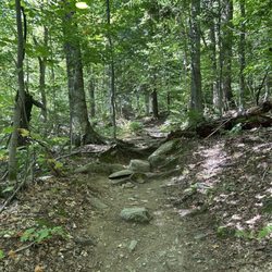
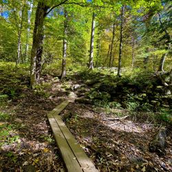
Beautiful part of Vermont for a short, scenic hike and dog friendly. If you are in the area most definitely stop by and see this wonder! In the summer it's crawling with swimmers and the fall is just hiking but bring water proof boots. Pictures don't do it justice! read more


Came here on a morning before the crowds came and, being midweek and at the end of summer, there still were not a lot of people as the morning wore on. There are arrows on the path pointing you in the direction(s) you want to go. Boulders are pretty slippery, so watch your step. The river water, almost turquoise in color, was. as expected, very cold but super refreshing, Waterfalls were mesmerizing. Lots of places on the riverbank & even the riverbed to hang out in the sun, or, of course, dive into the deeper swimming holes. There is a small parking lot, dogs have to be leashed, and carry out what you bring in. read more


3 years ago
Me and my husband recently visited warren falls, it wasn't a hike, just a 2-3min walk to the falls we enjoyed the walk because it has water crosswalks and slides! Water was cold though so we couldn't get down into the water! We might have got a chance to get into water if we visited this place in June July months! Great place to just have some serenity time read more


8 years ago
Warren Falls is a MUST - wow, absolutely breathtaking! At our stop in Moss Glen Falls, we met an avid traveler who visits the falls in Vermont each year. Without him, we wouldn't have known about this stop! Unlike some of the other falls we saw on this trip, Warren falls has a clearly marked parking lot. Once you park, you can start a semi-easy hike to the falls. I 100% recommend water shoes for this hike, as I think the best part is being able to enjoy the water once you hit the falls. The hike to the falls isn't hard, but it's a little narrow with a bit of up and down. Once you make it to the falls it is absolutely gorgeous. Crystal clear water - something straight out of a movie. Then, there are small cliffs where you can jump into the water. DO IT! I am the most scared and non-adventurous person ever, and I jumped right into the water and loved every second. We visited in late July and the water was FREEZING (granted, from Miami here but still). But regardless, it felt really nice to dive in and enjoy all that Warren Falls had to offer. Really fun activity, and something I won't soon forget. PS - use the bathroom before you arrive, I didn't spot any facilities as part of the park. read more


3 years ago
Gorgeous falls. Not much of a hike with 18 inches of snow, but definitely worth the short drive and 20 steps from the lot to the viewing platform. read more


About a forty five minute drive from Stowe and worth the trip! Of course, being from South Florida, just driving along the picturesque mountain roads are a delight! I knew there was great hiking in Stowe, but before I got there I had no idea that there were so many beautiful waterfalls to explore! At Warren Falls there is a small parking area. During peak summer hours, many cars park across the street along the road. It is an easy walk to the falls. Even in the summer the area was shaded and cool, and the water is cold. You can dive from a couple of locations. One cliff is higher and one is lower. The kids loved jumping in the water and exploring the rock formations. I recommend wearing water shoes and using the bathroom before you get there. There are no facilities! Great activity on a beautiful summer day! read more


6 years ago
More info about Warren Falls
Route 100
Warren, VT 05674
Directions
Hours
Outdoor Amenities
Ask the Community - Warren Falls
Review Highlights - Warren Falls


Why does Yelp recommend reviews?
1 review that is not currently recommended
The reviews below are not factored into the business's overall star rating.
5 years ago
Warren Falls - hiking - Updated July 2026
Best of Warren
People found Warren Falls by searching for…
Things to Do in Warren, Vermont
Swimming Holes in Warren, Vermont
Playgrounds in Warren, Vermont
Hiking Trails With Waterfalls in Warren, Vermont
Scenic Drive in Warren, Vermont
Off Leash Dog Hikes in Warren, Vermont
River Swimming in Warren, Vermont
Dog Friendly Hiking Trails in Warren, Vermont
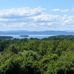
Scenic Views in Warren, Vermont
Beautiful Views in Warren, Vermont
Dog Swimming in Warren, Vermont
Walking Trails in Warren, Vermont
Water Parks for Kids in Warren, Vermont
Hikes With Dogs in Warren, Vermont
Off Road Trails in Warren, Vermont
Running Trails in Warren, Vermont
People who viewed Warren Falls also viewed
Bartlett's Falls
7 reviews
Wu Ledges Forest
2 reviews
Snake Mountain
3 reviews
Mt Philo State Park
22 reviews
Moss Glen Falls
17 reviews
Robert Frost Interpretive Trail
4 reviews
Lareau Swimming Hole
1 review
Stay Bent Fishing Tours
7 reviews
Vermont Icelandic Horse Farm
23 reviews
Vermont Skydiving Adventures
9 reviews