Virginia Creeper Trail Photos


More like Virginia Creeper Trail
Recommended Reviews - Virginia Creeper Trail
Start your review...

Reviews With Photos

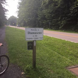
The name for this trail seems bizarre; who wants to walk while imagining someone creeping up behind you? I figured maybe it was named for a vine that grows along the trail or something, but in fact this is a rail to trail park and the train that used to use this right of way was called the creeper because of the windy path it took up the nearby mountains. The segment I tried was quite pleasant. A wide trail with soft ground and a bit of light gravel, it offered views of majestic farms on one side and a local school and skate park on the other. Parking was ample, and bathroom facilities were near the end of the trail. It runs a substantial distance and I didn't have time for all of it, but it appears to be an excellent resource.

Super well maintained and absolutely delightful trail. Great for all levels (if you go downhill) but def need a hybrid or mountain bike to ride. We opted to park in Damascus and get shuttled to the top. The drive took about 15-20 mins. This meant we got to cycle down to our car. Loved seeing the scenery (it's a rail to trail). There's a ton of river spots, bridges and shops/cafes. Plenty of spots or stop for a snack or meal along the way. Friendly bikers and walkers. Super clean and wide. Feels safe and an excellent way to check out to check in to nature.

"It's two trails really, that meet in Damascus, a mountain bike trail, and a farm fields trail", Charles, Shuttle Driver. No more true words were spoken but we didn't hear them until second day. Since my wife and I did have two different experiences I am going to parse this review out that way. We stayed in Abingdon as a home base. Bikes: Cannondale Topstone 3, 37mm WTB Riddler gravel tires. 21 SEP : Sunny, 80 degrees, 1500 start, 21 miles We took off from the Abingdon (AB) trailhead, large, gravel/dirt parking lot and headed towards Damascus (DS). The original goal was 10 out and return. We had been in the car all day (from Ft. Meade, MD) so we just wanted to see the trail a bit and get a little saddle time. Leaving AB is a low grade downhill for a few miles then, for the most part reasonably flat with a little climb after Alvarado and going towards DS. This is the farm field trail, it is a combination of open fields, rolling along a forested river. Mostly shady but there are some open areas. It is lovely, an easy peddle and any level of rider would enjoy this portion. The other interesting thing is passing through peoples back/front yards, and at times the trail reduces to a single dirt lane in a field or along a road. 22 SEP: Partly Cloudy/Breezy, 65-73 degrees, 1000 start, 34 Miles We took a shuttle from AB to Whitetop (WT), this was the advice we got from most reviews we read, and postings we saw in FB regarding use of the trail. People say the trail from WT to DS is a "downhill". What I would say is depending on your bike, your age, your riding level and comfort with rocky/slippery terrain this is true with a caveat. The first 4 miles or so is a brake feathering, almost breakneck, lunge (got to 24mph). [caveat: On our bikes, maybe not true on ebikes/mountain/upright hybrids] We stopped a few times to take pictures, and flex tense body parts. It calms down a bit after that but remains rocky, and a bit slippery because it was wet although it hadn't rained since 12 SEP. The last portion coming into DS is relatively flat. There are 40 trestles total, some still have the metal frame but all are wooden surface, sturdy and good railings. I had no concerns, and while my spouse was nervous beforehand, she did great and I am so very proud of her strength of will. I was doing the return on investment thing in my thinking. I was looking at it as 24 hours of leave, driving 780 miles, two nights hotel, and meals to ride 55 miles on bikes. My spouse reminded me, and I love her for it..."you were counting the wrong beans". The trail was very nice and a great resource. The 3 days overall experience was priceless.

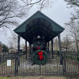
Time for a nice walk and get out of the car for a bit, I stopped here to check out the interesting locomotive on display. Bummer that it's behind a fence but I suppose that keeps it from getting damaged by people. The trailhead here in Abingdon has a large parking lot and it was in use today by a number of bikers and what looked like an organized bunch with a van that dropped them off and will pick them up down the trail. The trail runs for 34 miles from here in Abingdon through Damascus, and ending just past Whitetop Station in the Mount Rogers National Recreation Area, at the Virginia-North Carolina border. It might be used for pedestrians but it definitely looked to be getting more use from cyclists. Enjoy! [Review 14973 overall, 475 of 2021, number 1273 in Virginia.]

It's all downhill. You hardly need to pedal. Then it flattens out. Anyone including octogenarians and kiddos can do this in a heartbeat. I didn't pack snacks. Or fancy gear. Just sunglasses and a waterpack. Yup. I showed up. Rented a bike. And off we go. What I'm trying to say is: don't sweat all the small stuff. What a darling trail. Surrounded by greenery, a flowing brook, scattered patches boulders to climb, and a few meandering goats, you'll pass across bridges, tunnels and spend most of your time breathing in clear air that smells like pure nature. Along the way you can stop and read informational signage or visit nearby landmarks. I don't classify this as a challenging trail. It's a leisurely trail. And a beautiful escape from the daily grind.

I am an avid cyclist and love riding gravel. I absolutely loved this trail and cannot wait to come back again. I stayed in Abingdon and rode the 67 mile round trip. It took me about 5 hours and 27 minutes including a lunch stop on the way back in Damascus. I didn't push hard and stopped for a few pictures. The climb up after Damascus is long with no breaks in the climbing, but it is not very steep. I averaged 11 mph on the climb without trying too hard. (I am a 51 year old that is 40 lbs overweight.) When going up the climb, you to have to be careful because people in big groups coming down seem to think the trail is one way. I had people on my side and they wouldn't move over as they seemed to not even see me. Other times, people would move out of their line right in front of me. So, be attentive since they are not. There were places open to refill with water but fountains were shut off due to the pandemic. (I put a cloth mask in my saddle bag.) I read some reviews that say the trail is too rough. I don't really know what they are talking about. Maybe they expected a greenway. It is much smoother than any typical gravel ride I've ever done. There are a few rough spots and it is mostly on the steeper portion between Damascus and Whitetop. It is nothing major though and still not bad at all. I rode my gravel bike with 38c tires and 42 psi in the rear, 40 psi front (set up tubless) and I weigh 225 lbs. The only time I wished for less pressure was on part of the descent. I didn't lower it as I felt the higher pressure would be better for the ride from Damascus to Abingdon. Especially considering there is a little climbing back into Abingdon. The entire trip was 67.5 miles according to my Wahoo which included going to the state line. If it matters to you, it is an easy ride from Whitetop station to the line and back as it is fairly flat. The climb to Whitetop is not bad at all. I never even used my easiest gear (1x setup) and averaged 11 mph without a pushing too hard. So, anyone in reasonable shape should be just fine and I think it is worth a try if you are. To me, the ride down is much more rewarding when you earned it. The scenery is beautiful and worth slowing down to enjoy. There are few gates to go through but they don't surprise you and it is no big deal. One farmer was with his cattle as I slowly rode through them. He was friendly and we chatted for a minute. I got lots of waves and smiles from locals. I cannot wait to come back with my brother.

The ride itself is fairly easy. In fact, I'd say it's more for the laziest of bike riders, lol because it's pretty much a gradually descending downhill ride with not much peddling required. You can stop at various points along the way to rest or snap pictures. You ride across several small wooden bridges. There's an old post office/country store early along the trail where you can stop for snacks, souvenirs and ask questions of the friendly rangers. It's worth a look anyway and there's also bathrooms nearby. Continue coasting down the trail and you'll encounter a cafe which is pretty popular and visited by most riders from what I could tell. It's your basic cafeteria food, sandwiches, hotdogs, etc. there's even a meatloaf sandwich which my friend got and it looked super dried out. I had a slaw dog which was marginal at best. The hotdog was some 14cent overpriced phony knockoff and covered in slaw. Wifey had a grilled cheese and it was nothing to write home about either. Our other friends had a wrap which they seemed to enjoy. I would definitely pack my own lunch if I had it to do over... Anyway, the ride was nice under the tree covered canopy trail. The trail itself was safe and well maintained. It was definitely worth the adventure and day outdoor. We used one of the outfitters in town to rent bikes which were very reasonable. It makes for a great outdoor activity and way to enjoy some nature. I'd recommend this Trail.

If you have ever heard of the Virginia Creeper Trail, it's likely that you've heard someone rave of the awesomeness that is the Virginia Creeper Trail. And here's a spoiler alert, I'm gonna brag on it too! The trail itself is an old railroad that has been converted and turned into a biking trail. You can ride up it, and some people do. But I don't trust those people. They're not likely human. I mean, why would you ride 17+ miles uphill when you can take a shuttle to the top and coast down? It's that easy! You can pedal and speed up your journey, or you can take your time and enjoy the scenery. And the let me tell you, the scenery is worth taking it. Crossing back and forth over the Appalachian Trail and the river, the trail is absolutely stunning. Pack a picnic and enjoy it on a giant rock in the river because there's nowhere to stop and eat until you are back into Damascus. If this sound intimidating, just know that if you can balance on a bike, you can do this! It's not strenuous. It's a great family activity! There are at least 20 beautiful wooden or metal bike bridges that you cross over and countless places to pull over and take a break. I usually stop several times and it averages me about 4 hours from top to bottom. There are port-a-potties every 8 miles, I think. It's an amazing way to spend the day outside! Once you do it once, you'll want to do it over and over!

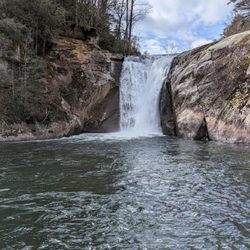
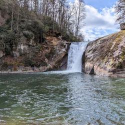
This may be the fastest, most solid five start rating I have ever smashed on Yelp. I've enjoyed two Memorial Day weekend vacations with family & friends spent biking The Creeper Trail and the experience is so thoroughly enchanting and dear that I cannot wait to go back to enjoy it again someday. Here's why: - You do not need to be in tip-top shape to bike this trail. Any first-timers concerned about having to break a sweat pedaling or generally wary of haulin' up any kind of incline (no matter how slight) should consider going for just the Whitetop to Damascus half of the trail. It's a gradual downhill ride so breezy that it makes 17 miles feel easier than a waltz and a cake walk. Speaking of cake, if food is a major motivator for you, there is a little diner along this span of the trail called the Creeper Trail Cafe that serves all kinds of comforting Appalachian-style Southern picnic foods, but their "world famous chocolate cake" takes on heavenly levels of palpable indulgence when eaten after you've been cruising your bike for 12 or so miles through such glorious nature as the Creeper Trail has to offer. - The trail is well marked, steeped in history, and surrounded by rustic pastoral vistas, natural waterfalls, babbling brooks, antique bridges, and, if you go in Spring, flowers, flowers, flowers! Sometimes it's easy for me to slip into daydreams if I catch a scent similar to the smell memories I have of the intoxicating high grass and blossoming honeysuckle vines that line the farmlands along Abingdon to Damascus half of the trail. Pure bliss. Also, it crosses and overlaps the Appalachian Trail in several spots--cool! - It's fun for the whole family! Every time I've biked the trail I've been in the company of many family and friends including my 80+ year old dad and my brother's young kids and we all rave about how rad the experience is. The only downside to the family funtime appeal is that the trail can get crowded on weekends and holidays. If you can make time during the week to do the Whitetop to Damascus part of the Creeper Trail (the more popular span), I 1000% guarantee it will be less crowded thus more enjoyable. Even the Friday before Memorial Day weekend was waaay more chill rider-wise. - You can build biking the Creeper Trail into a larger vacation touring Appalachian delights. Whether your taste in vacations skews towards outdoorsy activities, music history, arts & culture, regional food/festivals, roadside attractions, theme parks or other miscellaneous Americana, this corner of the US offers a bounty of attractions among which the Creeper Trail is, by any measure, a treasured diamond in the rough. I recommend renting your bikes (if you need to) and staying overnight in Damascus for two to three nights. That way you can be shuttled to the trail ends and bike the trail in halves over the course of two days, each day ending in Damascus. A word of caution: speaking as a dummy who nearly busted my own ass falling into a river while trying to balance on a slippery rock to get a better photo of one of the more majestic waterfalls along the Creeper Trail, don't risk your safety of the safety of others for unimportant stuff. Have fun, but mind the rules and have some sense. People can and do get hurt on the trail; just imagine how difficult a rescue effort would be in this remote mountain area and act accordingly.


What a nice leisurely stroll down the mountain. It will take you a few gorgeous hours to get from the top to be bottom over 17 miles of off-road trail friendly for the whole family. If you have your own bike, park at the bottom and go up and back down to get a little bit of a workout. It's not too hard in most places and worth the ride. Pick up your own trash and be mindful of the water provided to you and the items you bring. They will fall off your bike.
April, 2025. We visited Abington, Virginia quite a few years ago. After discovering the Virginia Creeper Trail at that time, we promised that we'd return "someday" to bike at least part of the trail. This trail is a nationally-acclaimed Rails-to-Trails that extends for 34 miles and over 47 trestle bridges. While best known as a biking trail, it's actually a multi-use trail with bikers, walkers, stroller pushers, runners, equestrians, and more, especially near the access points. In the past, the trail started near Whitetop, went about 18 miles to the center point near Damascus, and ended in the charming town of Abingdon (or vice versa). Unfortunately, Damascus was hard hit by Hurricane Helene, and 18 trestle bridges were destroyed as well as many portions of the trail so the Whitetop to Damascus portion of the trail is currently closed. The 18-mile stretch from Damascus to Abington IS open. While there are bike rental companies, as well as shuttle services to take you to the trail's start, we brought our own bikes. We decided to ride the 8.5 mile segment from Abingdon (elevation: 2,020' to Alvarado Station (the old train stop at 1,750') and back. This "lower" section is considered a relatively easy to moderate stretch through rolling farmland and forests and over beautiful trestle bridges. As mentioned, our turning point was Alvarado Station, where we enjoyed our picnic lunch on a bench river-side. The stop also had drinks and snacks available for sale, a water refill station, restrooms, and a big, friendly dog eyeing our lunches! The trail is wide in most areas, and is very well-maintained. There are multiple access points with parking lots, information kiosks, regular mileage markers, benches, photo ops, and some restrooms. In a relatively recent development, e-bikes are now allowed on the trail. With its restaurants, breweries, shops, local theater, and more, make some extra time to visit Abingdon! read more


4 months ago
Love riding the Virginia Creeper Trail. Most people ride it from Whitetop Mountain down to Damascus, but it's just as enjoyable riding the section from Abingdon to Damascus, and back. Both routes offer beautiful scenery and make for a great ride. read more


The name for this trail seems bizarre; who wants to walk while imagining someone creeping up behind you? I figured maybe it was named for a vine that grows along the trail or something, but in fact this is a rail to trail park and the train that used to use this right of way was called the creeper because of the windy path it took up the nearby mountains. The segment I tried was quite pleasant. A wide trail with soft ground and a bit of light gravel, it offered views of majestic farms on one side and a local school and skate park on the other. Parking was ample, and bathroom facilities were near the end of the trail. It runs a substantial distance and I didn't have time for all of it, but it appears to be an excellent resource. read more


2 years ago
Super well maintained and absolutely delightful trail. Great for all levels (if you go downhill) but def need a hybrid or mountain bike to ride. We opted to park in Damascus and get shuttled to the top. The drive took about 15-20 mins. This meant we got to cycle down to our car. Loved seeing the scenery (it's a rail to trail). There's a ton of river spots, bridges and shops/cafes. Plenty of spots or stop for a snack or meal along the way. Friendly bikers and walkers. Super clean and wide. Feels safe and an excellent way to check out to check in to nature. read more


"It's two trails really, that meet in Damascus, a mountain bike trail, and a farm fields trail", Charles, Shuttle Driver. No more true words were spoken but we didn't hear them until second day. Since my wife and I did have two different experiences I am going to parse this review out that way. We stayed in Abingdon as a home base. Bikes: Cannondale Topstone 3, 37mm WTB Riddler gravel tires. 21 SEP : Sunny, 80 degrees, 1500 start, 21 miles We took off from the Abingdon (AB) trailhead, large, gravel/dirt parking lot and headed towards Damascus (DS). The original goal was 10 out and return. We had been in the car all day (from Ft. Meade, MD) so we just wanted to see the trail a bit and get a little saddle time. Leaving AB is a low grade downhill for a few miles then, for the most part reasonably flat with a little climb after Alvarado and going towards DS. This is the farm field trail, it is a combination of open fields, rolling along a forested river. Mostly shady but there are some open areas. It is lovely, an easy peddle and any level of rider would enjoy this portion. The other interesting thing is passing through peoples back/front yards, and at times the trail reduces to a single dirt lane in a field or along a road. 22 SEP: Partly Cloudy/Breezy, 65-73 degrees, 1000 start, 34 Miles We took a shuttle from AB to Whitetop (WT), this was the advice we got from most reviews we read, and postings we saw in FB regarding use of the trail. People say the trail from WT to DS is a "downhill". What I would say is depending on your bike, your age, your riding level and comfort with rocky/slippery terrain this is true with a caveat. The first 4 miles or so is a brake feathering, almost breakneck, lunge (got to 24mph). [caveat: On our bikes, maybe not true on ebikes/mountain/upright hybrids] We stopped a few times to take pictures, and flex tense body parts. It calms down a bit after that but remains rocky, and a bit slippery because it was wet although it hadn't rained since 12 SEP. The last portion coming into DS is relatively flat. There are 40 trestles total, some still have the metal frame but all are wooden surface, sturdy and good railings. I had no concerns, and while my spouse was nervous beforehand, she did great and I am so very proud of her strength of will. I was doing the return on investment thing in my thinking. I was looking at it as 24 hours of leave, driving 780 miles, two nights hotel, and meals to ride 55 miles on bikes. My spouse reminded me, and I love her for it..."you were counting the wrong beans". The trail was very nice and a great resource. The 3 days overall experience was priceless. read more


, wonderful farm on both sides. - Hiking Near Me - Abingdon, Virginia")


Time for a nice walk and get out of the car for a bit, I stopped here to check out the interesting locomotive on display. Bummer that it's behind a fence but I suppose that keeps it from getting damaged by people. The trailhead here in Abingdon has a large parking lot and it was in use today by a number of bikers and what looked like an organized bunch with a van that dropped them off and will pick them up down the trail. The trail runs for 34 miles from here in Abingdon through Damascus, and ending just past Whitetop Station in the Mount Rogers National Recreation Area, at the Virginia-North Carolina border. It might be used for pedestrians but it definitely looked to be getting more use from cyclists. Enjoy! [Review 14973 overall, 475 of 2021, number 1273 in Virginia.] read more


Unique hiking experience! While hiking, my husband and I read up on the trail and were surprised by how rich its history is. We hiked about 3 miles until it started raining but we loved the trail, its tranquility, history, and sights. read more

2 years ago
3 years ago
10 years ago
It's all downhill. You hardly need to pedal. Then it flattens out. Anyone including octogenarians and kiddos can do this in a heartbeat. I didn't pack snacks. Or fancy gear. Just sunglasses and a waterpack. Yup. I showed up. Rented a bike. And off we go. What I'm trying to say is: don't sweat all the small stuff. What a darling trail. Surrounded by greenery, a flowing brook, scattered patches boulders to climb, and a few meandering goats, you'll pass across bridges, tunnels and spend most of your time breathing in clear air that smells like pure nature. Along the way you can stop and read informational signage or visit nearby landmarks. I don't classify this as a challenging trail. It's a leisurely trail. And a beautiful escape from the daily grind. read more


6 years ago
I am an avid cyclist and love riding gravel. I absolutely loved this trail and cannot wait to come back again. I stayed in Abingdon and rode the 67 mile round trip. It took me about 5 hours and 27 minutes including a lunch stop on the way back in Damascus. I didn't push hard and stopped for a few pictures. The climb up after Damascus is long with no breaks in the climbing, but it is not very steep. I averaged 11 mph on the climb without trying too hard. (I am a 51 year old that is 40 lbs overweight.) When going up the climb, you to have to be careful because people in big groups coming down seem to think the trail is one way. I had people on my side and they wouldn't move over as they seemed to not even see me. Other times, people would move out of their line right in front of me. So, be attentive since they are not. There were places open to refill with water but fountains were shut off due to the pandemic. (I put a cloth mask in my saddle bag.) I read some reviews that say the trail is too rough. I don't really know what they are talking about. Maybe they expected a greenway. It is much smoother than any typical gravel ride I've ever done. There are a few rough spots and it is mostly on the steeper portion between Damascus and Whitetop. It is nothing major though and still not bad at all. I rode my gravel bike with 38c tires and 42 psi in the rear, 40 psi front (set up tubless) and I weigh 225 lbs. The only time I wished for less pressure was on part of the descent. I didn't lower it as I felt the higher pressure would be better for the ride from Damascus to Abingdon. Especially considering there is a little climbing back into Abingdon. The entire trip was 67.5 miles according to my Wahoo which included going to the state line. If it matters to you, it is an easy ride from Whitetop station to the line and back as it is fairly flat. The climb to Whitetop is not bad at all. I never even used my easiest gear (1x setup) and averaged 11 mph without a pushing too hard. So, anyone in reasonable shape should be just fine and I think it is worth a try if you are. To me, the ride down is much more rewarding when you earned it. The scenery is beautiful and worth slowing down to enjoy. There are few gates to go through but they don't surprise you and it is no big deal. One farmer was with his cattle as I slowly rode through them. He was friendly and we chatted for a minute. I got lots of waves and smiles from locals. I cannot wait to come back with my brother. read more


4 years ago
The ride itself is fairly easy. In fact, I'd say it's more for the laziest of bike riders, lol because it's pretty much a gradually descending downhill ride with not much peddling required. You can stop at various points along the way to rest or snap pictures. You ride across several small wooden bridges. There's an old post office/country store early along the trail where you can stop for snacks, souvenirs and ask questions of the friendly rangers. It's worth a look anyway and there's also bathrooms nearby. Continue coasting down the trail and you'll encounter a cafe which is pretty popular and visited by most riders from what I could tell. It's your basic cafeteria food, sandwiches, hotdogs, etc. there's even a meatloaf sandwich which my friend got and it looked super dried out. I had a slaw dog which was marginal at best. The hotdog was some 14cent overpriced phony knockoff and covered in slaw. Wifey had a grilled cheese and it was nothing to write home about either. Our other friends had a wrap which they seemed to enjoy. I would definitely pack my own lunch if I had it to do over... Anyway, the ride was nice under the tree covered canopy trail. The trail itself was safe and well maintained. It was definitely worth the adventure and day outdoor. We used one of the outfitters in town to rent bikes which were very reasonable. It makes for a great outdoor activity and way to enjoy some nature. I'd recommend this Trail. read more


4 years ago
If you have ever heard of the Virginia Creeper Trail, it's likely that you've heard someone rave of the awesomeness that is the Virginia Creeper Trail. And here's a spoiler alert, I'm gonna brag on it too! The trail itself is an old railroad that has been converted and turned into a biking trail. You can ride up it, and some people do. But I don't trust those people. They're not likely human. I mean, why would you ride 17+ miles uphill when you can take a shuttle to the top and coast down? It's that easy! You can pedal and speed up your journey, or you can take your time and enjoy the scenery. And the let me tell you, the scenery is worth taking it. Crossing back and forth over the Appalachian Trail and the river, the trail is absolutely stunning. Pack a picnic and enjoy it on a giant rock in the river because there's nowhere to stop and eat until you are back into Damascus. If this sound intimidating, just know that if you can balance on a bike, you can do this! It's not strenuous. It's a great family activity! There are at least 20 beautiful wooden or metal bike bridges that you cross over and countless places to pull over and take a break. I usually stop several times and it averages me about 4 hours from top to bottom. There are port-a-potties every 8 miles, I think. It's an amazing way to spend the day outside! Once you do it once, you'll want to do it over and over! read more


9 years ago
This may be the fastest, most solid five start rating I have ever smashed on Yelp. I've enjoyed two Memorial Day weekend vacations with family & friends spent biking The Creeper Trail and the experience is so thoroughly enchanting and dear that I cannot wait to go back to enjoy it again someday. Here's why: - You do not need to be in tip-top shape to bike this trail. Any first-timers concerned about having to break a sweat pedaling or generally wary of haulin' up any kind of incline (no matter how slight) should consider going for just the Whitetop to Damascus half of the trail. It's a gradual downhill ride so breezy that it makes 17 miles feel easier than a waltz and a cake walk. Speaking of cake, if food is a major motivator for you, there is a little diner along this span of the trail called the Creeper Trail Cafe that serves all kinds of comforting Appalachian-style Southern picnic foods, but their "world famous chocolate cake" takes on heavenly levels of palpable indulgence when eaten after you've been cruising your bike for 12 or so miles through such glorious nature as the Creeper Trail has to offer. - The trail is well marked, steeped in history, and surrounded by rustic pastoral vistas, natural waterfalls, babbling brooks, antique bridges, and, if you go in Spring, flowers, flowers, flowers! Sometimes it's easy for me to slip into daydreams if I catch a scent similar to the smell memories I have of the intoxicating high grass and blossoming honeysuckle vines that line the farmlands along Abingdon to Damascus half of the trail. Pure bliss. Also, it crosses and overlaps the Appalachian Trail in several spots--cool! - It's fun for the whole family! Every time I've biked the trail I've been in the company of many family and friends including my 80+ year old dad and my brother's young kids and we all rave about how rad the experience is. The only downside to the family funtime appeal is that the trail can get crowded on weekends and holidays. If you can make time during the week to do the Whitetop to Damascus part of the Creeper Trail (the more popular span), I 1000% guarantee it will be less crowded thus more enjoyable. Even the Friday before Memorial Day weekend was waaay more chill rider-wise. - You can build biking the Creeper Trail into a larger vacation touring Appalachian delights. Whether your taste in vacations skews towards outdoorsy activities, music history, arts & culture, regional food/festivals, roadside attractions, theme parks or other miscellaneous Americana, this corner of the US offers a bounty of attractions among which the Creeper Trail is, by any measure, a treasured diamond in the rough. I recommend renting your bikes (if you need to) and staying overnight in Damascus for two to three nights. That way you can be shuttled to the trail ends and bike the trail in halves over the course of two days, each day ending in Damascus. A word of caution: speaking as a dummy who nearly busted my own ass falling into a river while trying to balance on a slippery rock to get a better photo of one of the more majestic waterfalls along the Creeper Trail, don't risk your safety of the safety of others for unimportant stuff. Have fun, but mind the rules and have some sense. People can and do get hurt on the trail; just imagine how difficult a rescue effort would be in this remote mountain area and act accordingly. read more


6 years ago
Always a blast! Must see in the fall months. I have been Terri years now and have enjoyed myself both times! We use Chelsea +Rob's Airbnb in downtown abingdon and they are amazing. The trigg room and the book room. The trail is charming and wonderful in every way. Happy biking!! read more


8 years ago
Great Trail! Started at Whitetop to Damascus. .had a nice ride down! Started early in the morning...take a thin jacket because even in the summer its cool coming off top! Loved it! read more

9 years ago
What a nice leisurely stroll down the mountain. It will take you a few gorgeous hours to get from the top to be bottom over 17 miles of off-road trail friendly for the whole family. If you have your own bike, park at the bottom and go up and back down to get a little bit of a workout. It's not too hard in most places and worth the ride. Pick up your own trash and be mindful of the water provided to you and the items you bring. They will fall off your bike. read more


Riding the Virginia Creeper Trail was a wonderful experience. One I can't wait to do again in the Fall cause I can only imagine how beautiful the trail will be at that time. We decided to be crazy (i.e. stupid) and ride the trail uphill from Damascus to White Top. I run a couple days a week but hadn't been on a bike in at least 9 months. The ride uphill was beautiful and wasn't really painful until the last 5 miles. I definitely recommend getting gel seats in addition to padded shorts. I struggled through the last 5 miles but finally made it to the top! At the top of the mountain, there is a book in the store where you can sign your name if you rode uphill. After getting recharged, we made our way back down to Damascus. The downhill ride was thrilling and fast. Absolutely loved it. However, riding uphill made me appreciate the beauty of the trail more since I was going slower. Riding uphill also enhanced the downhill experience. About 35 miles later, I was more appreciative of the diversity and beauty of nature. It made me more purposeful about my intent on traveling and seeing the world. And definitely sealed the fact that I will be back to ride this trail in the fall. Happy riding! read more


11 years ago
Obviously tons of fun. Great place to walk, run, bike, even horseback ride. Wonderful for kids anf adults. Always fairy flat surface and reasonably smooth' except patches of mud after rain. Mile markers help keep track of progress from trail head. My kids love all the "giant bridges." read more

6 years ago
Beautiful place for a wonderful bike ride through the woods. I recommend you have a reservation for a rental bike as we were lucky to get one on this gorgeous day. Everyone had a great time. read more

4 years ago
8 years ago
5 years ago
10 years ago
What an awesome ride! Flying down a mountain for 18 miles might sound terrifying but it's an amazing experience. You hardly have to pedal as you coast down the trail alongside a creek the majority of the way. It's beautiful, cool and the path is entirely enclosed by trees so it feels like you might run across a Hobbit leaving the Shire if you're paying attention. This is not something you want to miss. read more

6 years ago
9 years ago
Absolutely love the creeper! It's great for riding bikes riding horses, walking or walking pets plus it runs beside the AP trail! Love the bridges and the trails are well kept ! read more


9 years ago
8 years ago
9 years ago
9 years ago
9 years ago
7 years ago
Page 1 of 2
More info about Virginia Creeper Trail
300 Green Spring Rd
Abingdon, VA 24210
Directions
(276) 676-2282
Call Now
Visit Website
https://www.vacreepertrail.org
Hours
Indoor Amenities
Outdoor Amenities
Virginia Creeper Trail Reviews in Other Languages
Ask the Community - Virginia Creeper Trail
Review Highlights - Virginia Creeper Trail


Why does Yelp recommend reviews?
28 reviews that are not currently recommended
The reviews below are not factored into the business's overall star rating.
12 years ago
12 years ago
11 years ago
12 years ago
10 years ago
10 years ago
10 years ago
12 years ago
10 years ago
11 years ago
11 years ago
12 years ago
12 years ago
11 years ago
12 years ago
12 years ago
12 years ago
12 years ago
11 years ago
10 years ago
Virginia Creeper Trail - hiking - Updated June 2026
Best of Abingdon
People found Virginia Creeper Trail by searching for…
Horseback Riding in Abingdon, Virginia
Things to Do in Abingdon, Virginia
Hiking Trails With Waterfalls in Abingdon, Virginia
Places to Take Pictures in Abingdon, Virginia
Photo Spots in Abingdon, Virginia
Off Road Trails in Abingdon, Virginia
Attractions in Abingdon, Virginia
Flower Fields in Abingdon, Virginia
Waterfalls in Abingdon, Virginia
Scenic Overlook in Abingdon, Virginia
Beautiful Views in Abingdon, Virginia
Scenic View in Abingdon, Virginia
Parks for Kids in Abingdon, Virginia
Scenic Drive in Abingdon, Virginia
Running Trails in Abingdon, Virginia
Picnic Areas in Abingdon, Virginia
Dog Friendly Parks in Abingdon, Virginia
View Points in Abingdon, Virginia
Tourist Attractions in Abingdon, Virginia
Waterfalls and Swimming Holes in Abingdon, Virginia
Trending Searches in Abingdon, VA
Boat Rental near Virginia Creeper Trail
Cliff Jumping near Virginia Creeper Trail
Day Trips near Virginia Creeper Trail
Fishing Spots near Virginia Creeper Trail
Kayak Rental near Virginia Creeper Trail
Mountain Biking near Virginia Creeper Trail
Off Road Trails near Virginia Creeper Trail
Parks near Virginia Creeper Trail
Picnic Areas near Virginia Creeper Trail
Places To Swim near Virginia Creeper Trail
Pool Supplies near Virginia Creeper Trail
Public Shower near Virginia Creeper Trail
River Swimming near Virginia Creeper Trail
Scenic Overlook near Virginia Creeper Trail
Splash Pad near Virginia Creeper Trail
Strawberry Picking near Virginia Creeper Trail
Sunrise View near Virginia Creeper Trail
Swimming Holes near Virginia Creeper Trail
Swimming Lakes near Virginia Creeper Trail
Browse Articles
Browse Nearby
BEST of Abingdon, Virginia Parks near Virginia Creeper Trail
BEST of Abingdon, Virginia Coffee near Virginia Creeper Trail
BEST of Abingdon, Virginia Things to Do near Virginia Creeper Trail
BEST of Abingdon, Virginia Walking Trails near Virginia Creeper Trail
BEST of Abingdon, Virginia Restaurants near Virginia Creeper Trail
BEST of Abingdon, Virginia Breakfast near Virginia Creeper Trail
BEST of Abingdon, Virginia Caves near Virginia Creeper Trail
BEST of Abingdon, Virginia Campgrounds near Virginia Creeper Trail
BEST of Abingdon, Virginia Hot Springs near Virginia Creeper Trail
Browse Brands
Related Searches in Abingdon, VA
Affordable Bike Repair Services in Abingdon, Virginia
Affordable Bike Tune Up Services in Abingdon, Virginia
Best Dog Hiking Trails Around Abingdon, Virginia
Best Fishing Locations and Guides in Abingdon, Virginia
Best Fun Things to Do in Abingdon, Virginia
Best Places for Horseback Riding in Abingdon, Virginia
Best Places for Stunning Views in Abingdon, Virginia
Best Waterfalls and Swimming Holes in Abingdon, Virginia
Check Out Off Road Trails in Abingdon, Virginia
Discover Dog Friendly Trails to Explore in Abingdon, Virginia
Discover Popular Bike Trails in Abingdon, Virginia
Discover Scenic Mountain Bike Trails Near Abingdon, Virginia
Discover Top Nature Parks to Visit in Abingdon, Virginia
Discover Top State Parks to Visit in Abingdon, Virginia
Discover a Hiking Trail in Abingdon, Virginia
Discover the Best Night Hike Trails in Abingdon, Virginia
Dog-Friendly Hikes With Dogs in Abingdon, Virginia
Enjoy Camping Adventures Around Abingdon, Virginia
Enjoy Exciting Mountain Biking Adventures in Abingdon, Virginia
Enjoy Hiking Adventures in Abingdon, Virginia
Enjoy Scenic Night View Experiences in Abingdon, Virginia
Enjoy the Best Tubing Experiences in Abingdon, Virginia
Enjoy the Best Walking Trails in Abingdon, Virginia
Exciting Cliff Jumping Spots in Abingdon, Virginia
Experience Stunning Sunset Views in Abingdon, Virginia
Experience Thrilling White Water Rafting in Abingdon, Virginia
Explore Beautiful Parks and Green Spaces in Abingdon, Virginia
Explore Bike Rentals Throughout Abingdon, Virginia
Explore Easy Hikes Perfect for All in Abingdon, Virginia
Explore Electric Bikes Available in Abingdon, Virginia
Explore Family-Friendly Zoos and Wildlife in Abingdon, Virginia
Explore Free Things to Do Around Abingdon, Virginia
Explore Fun Activities to Do in Abingdon, Virginia
Explore Nature Spots Around Abingdon, Virginia
Explore Popular Campgrounds Near Abingdon, Virginia
Explore Popular RV Parks Around Abingdon, Virginia
Explore Popular Scenic Overlook Points in Abingdon, Virginia
Explore Popular View Points Around Abingdon, Virginia
Explore Scenic Lakes to Visit in Abingdon, Virginia
Explore Top Dog Parks in Abingdon, Virginia Near You
Explore Top Water Parks in Abingdon, Virginia Today
Explore the Best Boating Spots in Abingdon, Virginia
Explore the Best Swimming Holes Around Abingdon, Virginia
Explore the Best Trail Options in Abingdon, Virginia
Family Friendly Hiking With Kids in Abingdon, Virginia
Find Beautiful Views in Abingdon, Virginia
Find Fun Kids Activities Outdoor in Abingdon, Virginia
Find Popular Running Stairs Locations in Abingdon, Virginia
People who viewed Virginia Creeper Trail also viewed
Friends of Steele Creek Nature Center and Park
8 reviews
Sugar Hollow Park
9 reviews
South Holston Dam
6 reviews
Oxbow Lake Park
2 reviews
Abingdon Muster Grounds
3 reviews
Off the Grid Mountain Adventures
20 reviews
Backyard Terrors Dinosaur Park
31 reviews
The Traveling Bear Indoor Mini Golf
5 reviews
Tri-Cities Escape Game
18 reviews
Hall's Skateland
3 reviews