Three Bridges Oak Preserve Photos


You might also consider
More like Three Bridges Oak Preserve
Recommended Reviews - Three Bridges Oak Preserve
Start your review...

Reviews With Photos

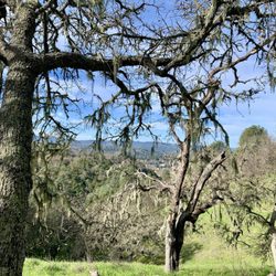
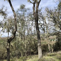
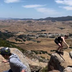
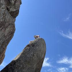
Great hike just outside of Atascadero. Wide trail that is routinely maintained, with signs along the way describing local plant life. The lower section zig zags up through a grassy grove of blue oak trees. The upper section goes through sections of chaparral intermixed with pockets of dense oak groves. Toward the top there is a beautiful cluster of madrone trees. And at the very top, a vista looking over much of north county with a sign that highlights local landmarks. I dropped a star because the trail parking lot is not always open. The slightest rain closes the parking lot. This just causes people to park elsewhere to access the trail.

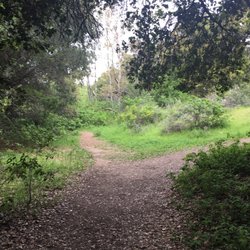
Wonderful picturesque beginner-moderate hike. One main trail but it splits into two which offers two types of challenges. One on the left is a straight smoothed out trails while the right offers a little bit more challenge with switchbacks and higher elevation steps. Beginning of the trail, there's a creek that still runs and great for dogs to drink or drench your clothes as they're splashing happily while trying to across the rocks. Be careful, there is poison oak, but we managed not to get any on us. I like that there is little fun factoid plaques of the animals and vegetation around the hiking trails. Lovely area and lots of shade too. Two issues for us was that there is a really lengthy route to get to the preserve. You have to go through a residential area. There is a short cut, but you kind of need a 4x4 and it was situated in a pool of mud. The other one is lack of parking, and some people got creative with it too.

We really enjoyed this 3.6 mile loop with 80% shade, well maintained trails (one creek crossing but with easy stepping stones). I appreciated the signage, especially pointing out and explaining the native flora and fauna. It was chilly most of the time this morning (48 degrees) but felt warmer in the sun. I'm sure this is a great little hike in all four seasons! We'll be back someday. read more


2 months ago
This hike in early April was beautiful, filled with wild flowers. There is a lot of traffic noise for the first part of the hike, but it gets better as you go up. Speaking of the incline, it meets my standards by starting low and going up fairly gradually. The views are incredible, and the hike back easy. It did feel longer than the posted signs claimed. read more

4 years ago
2 years ago
Great hike just outside of Atascadero. Wide trail that is routinely maintained, with signs along the way describing local plant life. The lower section zig zags up through a grassy grove of blue oak trees. The upper section goes through sections of chaparral intermixed with pockets of dense oak groves. Toward the top there is a beautiful cluster of madrone trees. And at the very top, a vista looking over much of north county with a sign that highlights local landmarks. I dropped a star because the trail parking lot is not always open. The slightest rain closes the parking lot. This just causes people to park elsewhere to access the trail. read more


7 years ago
Wonderful picturesque beginner-moderate hike. One main trail but it splits into two which offers two types of challenges. One on the left is a straight smoothed out trails while the right offers a little bit more challenge with switchbacks and higher elevation steps. Beginning of the trail, there's a creek that still runs and great for dogs to drink or drench your clothes as they're splashing happily while trying to across the rocks. Be careful, there is poison oak, but we managed not to get any on us. I like that there is little fun factoid plaques of the animals and vegetation around the hiking trails. Lovely area and lots of shade too. Two issues for us was that there is a really lengthy route to get to the preserve. You have to go through a residential area. There is a short cut, but you kind of need a 4x4 and it was situated in a pool of mud. The other one is lack of parking, and some people got creative with it too. read more

7 years ago
7 years ago
And amazing and secluded hike that will challenge you if you choose to run it. Wonderfully maintained trail with switchbacks that will keep your blood pumping. I hope I stumble upon this place once again! read more

5 years ago
7 years ago
7 years ago
More info about Three Bridges Oak Preserve
9930 Carmelita Ave
Atascadero, CA 93422
Directions
Visit Website
http://www.supportalps.org
Hours
Outdoor Amenities
Ask the Community - Three Bridges Oak Preserve
Review Highlights - Three Bridges Oak Preserve
You might also consider


Why does Yelp recommend reviews?
3 reviews that are not currently recommended
The reviews below are not factored into the business's overall star rating.
7 years ago
4 years ago
5 years ago
Three Bridges Oak Preserve - hiking - Updated May 2026
Best of Atascadero
People found Three Bridges Oak Preserve by searching for…
Things to Do in Atascadero, CA
Hiking Trails in Atascadero, CA
Running Trails in Atascadero, CA
Walking Trails in Atascadero, CA
Off Road Trails in Atascadero, CA
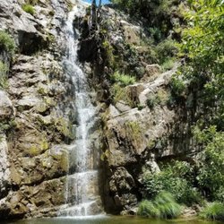
Waterfall Hike in Atascadero, CA
Sunrise View in Atascadero, CA
Sunrise Hike in Atascadero, CA
Fun Things to Do at Night in Atascadero, CA
Places to Take Pictures in Atascadero, CA
Tourist Attractions in Atascadero, CA
Stroller Friendly Hikes in Atascadero, CA
Secluded Spots in Atascadero, CA
Free Campgrounds in Atascadero, CA
Trending Searches in Atascadero, CA
Boat Rental near Three Bridges Oak Preserve
Botanical Gardens near Three Bridges Oak Preserve
Bounce House Rentals near Three Bridges Oak Preserve
Campgrounds near Three Bridges Oak Preserve
Cherry Picking near Three Bridges Oak Preserve
Cliff Jumping near Three Bridges Oak Preserve
Dog Friendly Things To Do near Three Bridges Oak Preserve
Flower Fields near Three Bridges Oak Preserve
Flower Shop near Three Bridges Oak Preserve
Garage Sales near Three Bridges Oak Preserve
Hair near Three Bridges Oak Preserve
Nurseries & Gardening near Three Bridges Oak Preserve
Outdoor Activities near Three Bridges Oak Preserve
Outdoor Furniture Stores near Three Bridges Oak Preserve
Parks near Three Bridges Oak Preserve
Party Equipment Rentals near Three Bridges Oak Preserve
Pedicure near Three Bridges Oak Preserve
Pick Your Own Farms near Three Bridges Oak Preserve
Picnic Areas near Three Bridges Oak Preserve
Places To Take Pictures near Three Bridges Oak Preserve
Rock Quarry near Three Bridges Oak Preserve
Running Trails near Three Bridges Oak Preserve
Scenic Drive near Three Bridges Oak Preserve
Secret Spots near Three Bridges Oak Preserve
Strawberry Picking near Three Bridges Oak Preserve
Sunrise View near Three Bridges Oak Preserve
Swimming Holes near Three Bridges Oak Preserve
Table And Chair Rentals near Three Bridges Oak Preserve
Browse Articles
Browse Nearby
BEST of Atascadero, California Restaurants near Three Bridges Oak Preserve
BEST of Atascadero, California Coffee near Three Bridges Oak Preserve
BEST of Atascadero, California Breakfast near Three Bridges Oak Preserve
BEST of Atascadero, California Things to Do near Three Bridges Oak Preserve
BEST of Atascadero, California Horseback Riding near Three Bridges Oak Preserve
BEST of Atascadero, California Shopping near Three Bridges Oak Preserve
BEST of Atascadero, California Hotels near Three Bridges Oak Preserve
Browse Brands
Related Searches in Atascadero, CA
Affordable Kayak Rental Services in Atascadero, California
Best Fishing Locations and Guides in Atascadero, California
Best Places for Horseback Riding in Atascadero, California
Best Places for Stunning Views in Atascadero, California
Check Out Off Road Trails in Atascadero, California
Discover Scenic Mountain Bike Trails Near Atascadero, California
Discover Scenic Waterfall Spots in Atascadero, California
Discover Top State Parks to Visit in Atascadero, California
Discover a Hiking Trail in Atascadero, California
Discover the Best Night Hike Trails in Atascadero, California
Dog-Friendly Hikes With Dogs in Atascadero, California
Enjoy Camping Adventures Around Atascadero, California
Enjoy Exciting Mountain Biking Adventures in Atascadero, California
Enjoy Kayaking Adventures in Atascadero, California
Enjoy Tent Camping Spots Around Atascadero, California
Enjoy a Beautiful Waterfall Hike in Atascadero, California
Enjoy the Best Picnic Spots and Ideas in Atascadero, California
Enjoy the Best Walking Trails in Atascadero, California
Explore Beautiful Parks and Green Spaces in Atascadero, California
Explore Easy Hikes Perfect for All in Atascadero, California
Explore Fun Activities to Do in Atascadero, California
Explore Popular Campgrounds Near Atascadero, California
Explore Top Dog Parks in Atascadero, California Near You
Explore the Best Beach Spots in Atascadero, California
Explore the Best Boating Spots in Atascadero, California
Explore the Best Trail Options in Atascadero, California
Family Friendly Hiking With Kids in Atascadero, California
Find Beautiful Views in Atascadero, California
Find Fun Kids Activities Outdoor in Atascadero, California
Find Parks and Recreation Activities in Atascadero, California
Find Popular Ziplining Spots Around Atascadero, California
Find the Best Parks for Picnics in Atascadero, California
Find the Best Playgrounds to Visit in Atascadero, California
Find the Best Scenic View Locations in Atascadero, California
Great Places to Walk in Atascadero, California
Hiking Trails With Waterfalls in Atascadero, California
Off Leash Dog Hiking Trails in Atascadero, California
Plan a Scenic Drive Route Near Atascadero, California
Popular Outdoor Activities to Try in Atascadero, California
Popular Picnic Spots to Visit in Atascadero, California
Popular Things to Do in Atascadero, California
Safe River Swimming Areas in Atascadero, California
Safe and Fun Parks for Kids in Atascadero, California
Top Places for Snorkeling in Atascadero, California
Top Playgrounds for Kids to Enjoy in Atascadero, California
Top Running Trails to Explore in Atascadero, California
Top Swimming Lakes to Enjoy in Atascadero, California
Top Swimming Spots and Pools in Atascadero, California
People who viewed Three Bridges Oak Preserve also viewed
Jim Green Trail
4 reviews
Bishop Peak
173 reviews
Los Osos Elfin Forest
72 reviews
Fiscalini Ranch Preserve
112 reviews
Morro Dunes Ecological Reserve
1 review
Irish Hills trails
2 reviews
Hiking Trails at San Simeon Bay
6 reviews
Morro Bay State Park
178 reviews
Ontario Ridge Trail Head at Shell Beach
6 reviews
Cloisters Park
17 reviews