Thornton Bales Conservation Area Photos


More like Thornton Bales Conservation Area
Recommended Reviews - Thornton Bales Conservation Area
Start your review...

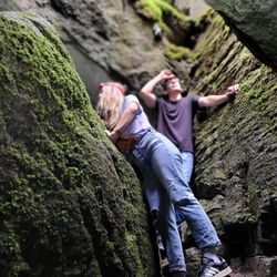
This is a review of the 99 Steps trail, located in the Thornton Bales Conservation Area. Located in Newmarket is a short 4 km loop trail called 99 Steps. It's located on 19th Sideroad between Dufferin and Bathurst. You'll know you're there when you see cars parked along the side of the narrow road. There is a small parking area for 9-10 cars at the trailhead. The trail starts with steps heading down. I don't know why it's called 99 Steps because there are only 80 steps (I counted). The trail is well maintained and has clear markers. There were only a couple of spots where it was unclear where the trail continues. The trail has some moderately steep downhill paths, so bring a walking stick if you have knee problems. Unfortunately, when I visited last week, a portion of the trail was closed, so it felt more like 2 km roundtrip. Overall, I thought it was a very nice trail and I'm looking forward to returning during the autumn when the leaves change colors. read more


4.5 Because of the pandemic, I've been trying to find more outdoors-y things to do and I've been having that itch to go on a satisfying hike. This trail connected to another named 99 steps is located in King city just 10 minutes from Upper Canada Mall. You may bring dogs here on leash. Parking is extremely limited, about 10 spaces and I wouldn't recommend parking on the side street. There have been reports that you will get ticketed about $50 for it so I recommend you to wait until someone leaves which was only a couple minutes for me. First off... please please please research the trails before you go. It is a good idea to do this for any trail because there can be trail closures/diversions that can change. For example this one is connected to the Koffler scientific reserve at joker's hill which is part of the U of T research. They have sections closed off for scientific research. I recommend googling it to see which sections are closed. This trail is rated as a moderately difficult meaning that it is very technical with hills, tree roots and some rocks which is normal for these types of trails. Wear good shoes with good traction to protect your feet. In the beginning, they make you start off with going down hill with the steps although there's only 80 (counted). You can walk only the 99 steps section or go further out and walk the larger loop that includes koffler. In total, it's about 6 kms if you walk it all and took about an hour and a half for me who walked it sorta quickly. . I thought the trail was fantastic. Blazes (paint on the trees) well marked in the beginning of the trail. FYI. Single paint=trail is straight, 2 stripes, left higher = trail turns left, right higher = trail turns right. Unfortunately, like another review said, the blazes disappeared at the second half of the trail and the all trails map isn't all that accurate so I walked an extra km by accident, but found the correct trail back and it's a single trail all the way back to the steps. I recommend downloading the all trails app and following as gps for that bit, but maybe I'll contact the conservation to make the blazes so people won't get lost. Still gonna be back because it's so so beautiful! Thanks for reading my long review/tips lol. read more


6 years ago
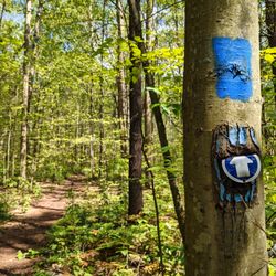
On our next hiking adventure, 99 Steps (Thornton Bales) was a seemingly good option for us and has been talked about through various articles. I did not care for it. Pros - Parking was good, there's a small lot but also a lot of people parked on the side of the roads. There were a lot of spots at 5pm on a Sunday. - Not a lot of people - Lots of trees n stuff - 99 Steps (more like 80 steps) was a nice little landmark but... The Ok/Bad - 80 steps was RIGHT IN THE BEGINNING OF THE HIKE! I mean obviously I don't blame them for that as that is how it was made, but my most enjoyable hikes have landmarks in the middle/end to help you get that sense of achievement. It was an anti-climax when we realized that it was almost the first steps you take. - What the heck is that useless map in the beginning for? Seriously? I've included a few photos to show them and you'll see that it gives you no information on the routes or the hike itself. I had to go on AllTrails for an extremely accurate map since to my next point: - Trees were marked with blue in the beginning to indicate where to go then it's like they gave up midway, but then also there's no map given? What does blue even mean? The AllTrails map showed us that it was supposed to be a large loop which is really great, but then as we walked on the left hand side, we saw that the route has been diverted from the AllTrails one. We followed that path and it led to a dead end. Maybe it wasn't a dead end... which leads to my next point: - The paths were not super enjoyable in my opinion. Lots of ups and downs, roots, etc, some paths get super narrow, most of the time it's okay but it was whatever and if there were a lot more people you would not be able to properly socially distance in these areas. The dead end was NOT maintained at all and there was no clear way. That led us having to backtrack all the way to the beginning and start the loop the other way around. By this time, we did about 1/4 of the loop on the other side but our group did not care anymore and we went back. We saw the steps, there was nothing else to enjoy, and who knew if the loop continued at the dead end we encountered. - Also there's no bathrooms or garbage cans. I know, I know, I ripped into this conservation area. I'm sorry. For those who like to hike like me (a psycho who enjoys nature in a certain way) then I can't recommend it here. Visited during the pandemic. 2.5/5. read more


5 years ago
5 years ago
I visited this trail on a Saturday afternoon around 3:00 and it was quite busy. The parking lot was full so we had to park on the road (we got a parking ticket so don't park on the road). This trail is only around 1.5km long and people usually visit for the 99 steps. There were a LOT of very young kids there, some even on bikes but I don't think this hike is suitable for kids. There are lots of ups and downs, some quite steep and almost dangerous for young kids especially on bikes. The trails were not maintained very well making some of the paths quite unclear. As someone who loves to hike, this will not be a trail I will be revisiting. Don't get me wrong, it's a nice short trail, with some (somewhat) challenging terrain but this trail is nothing special. One thing to note is that 90% of the people do not wear masks there, which would be fine since we are outdoors but the paths are not wide enough for social distancing if people are walking from the opposite direction. This is especially tough on the stairs when people coming up the stairs are running and breathing so heavily past you. Hopefully the trails are less busy on weekdays but beware of the number of people on weekends. read more


More info about Thornton Bales Conservation Area
Mulock Sideroad
King, ON L7B 1K5
Canada
Directions
Hours
Outdoor Amenities


Thornton Bales Conservation Area - hiking - Updated July 2026
People found Thornton Bales Conservation Area by searching for…
Hiking Trails in King, Ontario
Fun Things to Do in King, Ontario
Walking Trails in King, Ontario
Walking Groups in King, Ontario
Make Out Spot in King, Ontario
Beautiful Views in King, Ontario
Places to Visit in King, Ontario
Off Road Trails in King, Ontario
Parks for Kids in King, Ontario
Fun Things to Do on Your Birthday in King, Ontario
Things to Do With Kids in King, Ontario
Running Trails in King, Ontario
Mountain Biking in King, Ontario
Fun Places to Go in King, Ontario
Free Things to Do in King, Ontario
Tourist Attractions in King, Ontario
Things to Do Alone in King, Ontario
Hiking Groups in King, Ontario
Fun Things to Do on a Saturday Night in King, Ontario
Browse Articles
Browse Brands
Related Searches in King, ON
Best Fishing Locations and Guides in King, Ontario
Best Fun Things to Do in King, Ontario
Best Off Leash Dog Parks in King, Ontario
Best Places for Horseback Riding in King, Ontario
Discover Kid Friendly Hiking Trails in King, Ontario
Discover Public Beaches to Visit in King, Ontario
Discover Stunning Skyline View Spots in King, Ontario
Discover a Hiking Trail in King, Ontario
Effective Stairs Workout Spots in King, Ontario
Enjoy Camping Adventures Around King, Ontario
Enjoy Exciting Mountain Biking Adventures in King, Ontario
Enjoy Kayaking Adventures in King, Ontario
Enjoy Scenic Night View Experiences in King, Ontario
Enjoy Tent Camping Spots Around King, Ontario
Enjoy the Best Family Activities in King, Ontario
Enjoy the Best Picnic Spots and Ideas in King, Ontario
Experience Stunning Sunset Views in King, Ontario
Explore Beautiful Botanical Gardens in King, Ontario
Explore Beautiful Parks and Green Spaces in King, Ontario
Explore Bike Rentals Throughout King, Ontario
Explore Family-Friendly Zoos and Wildlife in King, Ontario
Explore Nature Spots Around King, Ontario
Explore Popular Campgrounds Near King, Ontario
Explore Popular RV Parks Around King, Ontario
Explore Popular View Points Around King, Ontario
Explore Scenic Lakes to Visit in King, Ontario
Explore Top Dog Parks in King, Ontario Near You
Explore Top Water Parks in King, Ontario Today
Explore the Best Boating Spots in King, Ontario
Explore the Best Swimming Holes Around King, Ontario
Explore the Best Trail Options in King, Ontario
Find Beautiful Views in King, Ontario
Find Fun Things to Do With Kids in King, Ontario
Find Popular Ziplining Spots Around King, Ontario
Find Top Dog Swimming Spots in King, Ontario
Find the Best Playgrounds to Visit in King, Ontario
Find the Best Scenic View Locations in King, Ontario
Picnic Areas With BBQ Pits Available in King, Ontario
Plan a Scenic Drive Route Near King, Ontario
Popular Fishing Spots to Explore in King, Ontario
Popular Kids Activities in King, Ontario
Popular Places to Take Pictures in King, Ontario
Popular Things to Do in King, Ontario
Top Climbing Spots and Gyms in King, Ontario
Top Swimming Lakes to Enjoy in King, Ontario
Top Things to Do With Kids in King, Ontario
Top-Rated Boat Rental Services in King, Ontario
Visit Popular BBQ Park Locations in King, Ontario
People who viewed Thornton Bales Conservation Area also viewed
Bob Hunter Memorial Park
5 reviews
Box Grove
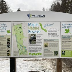
Maple Nature Reserve
3 reviews
East Don Parkland
6 reviews
Bayview Village
Albion Hills Conservation Park
5 reviews
Nokiidaa Tail - Green Lane
3 reviews
Forest Therapy Trail
2 reviews
Forks of the Credit Provincial Park
10 reviews
Milne Dam Conservation Park
10 reviews
Unionville
Oak Ridges Corridor Conservation Reserve
2 reviews
Boyd Conservation Area
8 reviews
Pine Grove