Grant's Woods Photos


More like Grant's Woods
Recommended Reviews - Grant's Woods
Start your review...

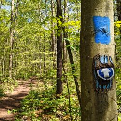
This is a beautiful park with several short (less than 2 kilometres) hiking trails that go into a forest. There are lots of different plants, neat wooden bridges, super big trees and an abandoned old car, for some reason. It's a pretty easy walk, the ground is soft and there weren't any inclines or tough, rocky areas that I could see. It was just nice and serene, except for the sounds of some wood processing plant nearby. There's parking enough for about 20 cars, and it's free. read more


13 years ago
More info about Grant's Woods
1485 Division Road W
Orillia, ON L3V 6H2
Canada
Directions
(800) 465-3636
Call Now
Hours
Outdoor Amenities


Grant's Woods - hiking - Updated July 2026
People found Grant's Woods by searching for…
Browse Articles
Browse Brands
Related Searches in Orillia, ON
Best Fishing Locations and Guides in Orillia, Ontario
Best Fun Things to Do in Orillia, Ontario
Best Places for Horseback Riding in Orillia, Ontario
Discover Dog Friendly Beaches Near Orillia, Ontario
Discover Top Boat Tours in Orillia, Ontario for All Ages
Discover the Best Running Track in Orillia, Ontario
Enjoy Exciting Mountain Biking Adventures in Orillia, Ontario
Enjoy the Best Picnic Spots and Ideas in Orillia, Ontario
Explore Beautiful Botanical Gardens in Orillia, Ontario
Explore Beautiful Parks and Green Spaces in Orillia, Ontario
Explore Bike Rentals Throughout Orillia, Ontario
Explore Family-Friendly Zoos and Wildlife in Orillia, Ontario
Explore Fun Activities to Do in Orillia, Ontario
Explore Jet Skis for Sale or Rent in Orillia, Ontario
Explore Popular Boat Charters Near Orillia, Ontario
Explore Popular Campgrounds Near Orillia, Ontario
Explore Popular RV Parks Around Orillia, Ontario
Explore Scenic Lakes to Visit in Orillia, Ontario
Explore Top Dog Parks in Orillia, Ontario Near You
Explore Top Water Parks in Orillia, Ontario Today
Explore Volleyball Courts Available in Orillia, Ontario
Explore the Best Boating Spots in Orillia, Ontario
Find Popular Ziplining Spots Around Orillia, Ontario
Find Top Skate Parks in Orillia, Ontario for All Skill Levels
Find the Best Playgrounds to Visit in Orillia, Ontario
Find the Best Swimming Pools in Orillia, Ontario Today
Popular Fishing Spots to Explore in Orillia, Ontario
Popular Kids Activities in Orillia, Ontario
Popular Things to Do in Orillia, Ontario
See Top Fireworks Events in Orillia, Ontario
Top Fishing Charter Experiences in Orillia, Ontario
Top Paddleboarding Activities in Orillia, Ontario
Top Playgrounds for Kids to Enjoy in Orillia, Ontario
Top-Rated Basketball Courts to Play at in Orillia, Ontario