Maple Nature Reserve Photos


More like Maple Nature Reserve
Recommended Reviews - Maple Nature Reserve
Start your review...

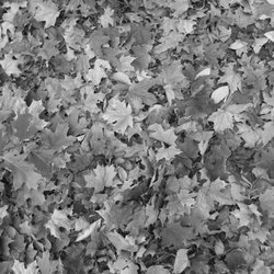
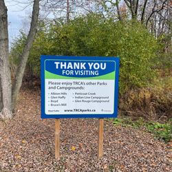
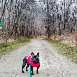
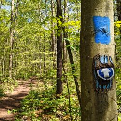
Maple Nature Reserve is a hidden gem, nestled in the stretch of road on Dufferin between Major Mackenzie and Teston. It's easy to miss and you'd never know that it was there as you drive by. There are 4 parking spots in the parking lot, but I've seen others park on the grass. It's a 3km circuit hike that includes inclines, some are quite steep. From the parking lot, you can take the Salamander Valley Trail, which is a dirt trail and can get a bit muddy after a rain. Once you're off the Salamander Valley Trail, everything is gravel trail. There are some isolated sections where you can easily forget that you're still in a city. There are plenty of trail maps along the way so that you really can't get lost. There could be better signage at major landmarks. For instance, the trail map indicates that there's an arboretum but I couldn't find it. It's ironic since arboretums are usually have tags identifying trees and plants. Overall, this trail is a good way to get out into nature while still being in the middle of a city. read more


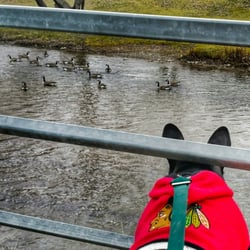
Friend found this spot while trying to find a middle spot to meet up with friends for an easy hike. The entrance could be difficult to find as it's a little hidden. Small parking lot, with one port-a-potty for washroom needs. It'sa very easy loop trail with a pond and close to residential houses. Some of the trails can lead to dead ends, but there were plenty of signs by each fork where it points out where you are located so it's very hard to get lost. There were also a wooden teepee that someone built along the trail. I would say it'd take approximately 20-30 minutes to complete a walk around. read more

More info about Maple Nature Reserve
10401 Dufferin Street
Vaughan, ON L6A 1S2
Canada
Directions
Hours
Outdoor Amenities


Maple Nature Reserve - hiking - Updated July 2026
People found Maple Nature Reserve by searching for…
Hiking Trails in Vaughan, Ontario
Secret Spots in Vaughan, Ontario
Tourist Attractions in Vaughan, Ontario
Walking Trails in Vaughan, Ontario
Fun Things to Do in Vaughan, Ontario
Waterfalls in Vaughan, Ontario
Walking Groups in Vaughan, Ontario
Night Walk in Vaughan, Ontario
Lakes & Ponds in Vaughan, Ontario
Off Road Trails in Vaughan, Ontario
Free Things to Do in Vaughan, Ontario
Hidden Gem in Vaughan, Ontario
Running Trails in Vaughan, Ontario
Fishing Spots in Vaughan, Ontario
Places to Take Pictures in Vaughan, Ontario
Scenic Places to Walk in Vaughan, Ontario
Waterfall Hike in Vaughan, Ontario
Public Gardens in Vaughan, Ontario
Picnic Areas in Vaughan, Ontario
What to Do in Vaughan, Ontario
Secluded Spots in Vaughan, Ontario
Browse Articles
Browse Brands
Related Searches in Vaughan, ON
Affordable Kayak Rental Services in Vaughan, Ontario
Best Fishing Locations and Guides in Vaughan, Ontario
Best Nature Trails for Hiking in Vaughan, Ontario
Best Places for Horseback Riding in Vaughan, Ontario
Best Sledding Spots and Fun in Vaughan, Ontario
Check Out Off Road Trails in Vaughan, Ontario
Discover Kid Friendly Hiking Trails in Vaughan, Ontario
Discover Scenic Waterfall Spots in Vaughan, Ontario
Discover a Hiking Trail in Vaughan, Ontario
Discover the Best Running Track in Vaughan, Ontario
Enjoy Camping Adventures Around Vaughan, Ontario
Enjoy Exciting Mountain Biking Adventures in Vaughan, Ontario
Enjoy Kayaking Adventures in Vaughan, Ontario
Enjoy Tent Camping Spots Around Vaughan, Ontario
Enjoy a Beautiful Waterfall Hike in Vaughan, Ontario
Enjoy the Best Family Activities in Vaughan, Ontario
Enjoy the Best Picnic Spots and Ideas in Vaughan, Ontario
Enjoy the Best Walking Trails in Vaughan, Ontario
Explore Beautiful Parks and Green Spaces in Vaughan, Ontario
Explore Bike Rentals Throughout Vaughan, Ontario
Explore Fun Activities to Do in Vaughan, Ontario
Explore Nature Spots Around Vaughan, Ontario
Explore Popular Campgrounds Near Vaughan, Ontario
Explore Scenic Lakes to Visit in Vaughan, Ontario
Explore Top Dog Parks in Vaughan, Ontario Near You
Explore the Best Beach Spots in Vaughan, Ontario
Explore the Best Boating Spots in Vaughan, Ontario
Explore the Best Swimming Holes Around Vaughan, Ontario
Find Beautiful Views in Vaughan, Ontario
Find Popular Ziplining Spots Around Vaughan, Ontario
Find the Best Playgrounds to Visit in Vaughan, Ontario
Find the Best Scenic View Locations in Vaughan, Ontario
Hiking Trails With Waterfalls in Vaughan, Ontario
Picnic Areas With BBQ Pits Available in Vaughan, Ontario
Plan a Scenic Drive Route Near Vaughan, Ontario
Popular Fishing Spots to Explore in Vaughan, Ontario
Popular Kids Activities in Vaughan, Ontario
Popular Outdoor Activities to Try in Vaughan, Ontario
Popular Picnic Spots to Visit in Vaughan, Ontario
Popular Things to Do in Vaughan, Ontario
Popular Things to See in Vaughan, Ontario
Safe and Fun Parks for Kids in Vaughan, Ontario
Top Climbing Spots and Gyms in Vaughan, Ontario
Top Paddleboarding Activities in Vaughan, Ontario
Top Places for Snorkeling in Vaughan, Ontario
Top Playgrounds for Kids to Enjoy in Vaughan, Ontario
Top Running Trails to Explore in Vaughan, Ontario
Top Swimming Spots and Pools in Vaughan, Ontario
People who viewed Maple Nature Reserve also viewed
Thornton Bales Conservation Area
5 reviews
Bob Hunter Memorial Park
5 reviews
Box Grove
Oak Ridges Corridor Conservation Reserve
2 reviews
Etobicoke Valley Park
2 reviews
Etobicoke
Eldred King Woodlands
2 reviews
Forest Therapy Trail
2 reviews
Nokiidaa Tail - Green Lane
3 reviews
Etobicoke Creek Trail
3 reviews
Boyd Conservation Area
8 reviews
Pine Grove
Taylor Creek Park
11 reviews