"The Grapevine" I-5 North Photos


You might also consider
More like "The Grapevine" I-5 North
Recommended Reviews - "The Grapevine" I-5 North
Start your review...

Reviews With Photos

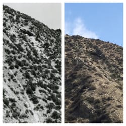
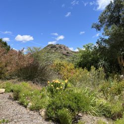
I've lived in California all my life and have been on the Grapevine countless times...but I've never seen the hillsides look this beautiful with color. Wildflowers making a spectacular appearance thanks to some much needed rain in this part of California. Oddly enough for all those times on that road I've never seen it covered in snow...I think that's a good thing because I've heard being stranded there is not fun, but it would be a treat to see it in glorious white. Must add that to my list of "must do's". I have been through it when parts were on fire, that's not pretty, but seeing the firefighters doing their thing is quite impressive. The drive through Gorman, Frasier mountain, Ft. Tejon and points in between is only 20-30 minutes, assuming traffic is moving.
 North & southbound entrances")
"The Grapevine," also known as Grapevine Hill. (Truth be told, this 40 mile stretch of the I-5 HWY isn't technically called The Grapevine... 'Lucky for me, I never worked IT.) Photo - https://www.yelp.com/biz_photos/the-grapevine-i-5-north-castaic?select=HvIUfFy9wgEU6kqGFL-GHg Whether you're road trip'n, headed north or south, The Grapevine is always one of those landmark points on the drive. With me, if I'm headed north from South OC, it's my two hour mark out, Magic Mountain being 1 1/2 hr. When I hit the bottom of that hill, I'm about 4-5 hours out until I hit the SF Bay Area and visa versa. When I travel with the HAPA, my bully pit, you can easily add an extra 1-2 hours... 'And if I'm tired, add an extra 3-5 hours. (i.e. - Rest area sleepy time) Now, entering Grapevine Hil - https://www.yelp.com/biz_photos/the-grapevine-i-5-north-castaic?select=pLSs1PPG8EBHF3ARfoqnMQ I don't usually make regular stops while passing through Grapevine Hill but if I do, it's usually at the Tejon Pass Safety Roadside Rest Area on my BARTs. (Bay Area Road Trips - Northbound) Teton Pass Rest Area (Photo) - https://www.yelp.com/biz_photos/the-grapevine-i-5-north-castaic?select=d_31gMz8KAPhiHS5jY7suQ There are two stories that address how the name, The Grapevine, came about: 1. The route resembled that of an actual grapevine. 2. Back in the day, the route was thick with overgrown grapevines and travelers had to literally hack their way through. (I believe this one to be the more accurate of the two.) Photo - https://www.yelp.com/biz_photos/the-grapevine-i-5-north-castaic?select=DyBq_jopS6-PWZcUPDqkqw Whether you make the I-5 road trip once or twice a year or every two months, be safe. If you're feeling tired, pull over @ one of the rest areas. If you're too tired to reach a rest area, find a well lit gas station to stop at and get some sleep. I used to make this drive once every two months before I originally moved to Southern California. It would always sadden me along with a bit of anger whenever I would see a single car, auto accident which most of the time was due to driver fatigue. On a few occasions, there was a blue body bag alongside the totaled, overturned vehicle. (That's a few more than I ever wanted to see.) Idiots. Pull over, take a small nap, wake up, grab a cup of coffee and be on your way. Now, someone's wife, husband, children, or parents are going to get a call @ 3am with the bad news. (Sigh) Safe & smart travels my friends. Nearing the final stretch of The Grapevine - https://www.yelp.com/biz_photos/the-grapevine-i-5-north-castaic?select=N5kqzPLOSIz0MekjKmxpAQ I created two Yelp*, Grapevine check points, one for northbound travelers and another for southbound. Both are set up @ the relative entry points of Grapevine Hill depending on which direction you're headed. Whenever I would make the drive and attempt to check-in @ The Grapevine... (Insert buzzer sound here) 'Nada, nothing, zilch. - "Wrong answer, do not pass GO, do not collect $200, but thank you for playing." So, on this last quick trip to SoCal, I thought, "It is time." **Note: Be sure to check weather conditions if you're planning on driving through The Grapevine, severe rain/snow can create road closures not to mention mudslides as of late. (i.e. - Sh'tuck) The Grapevine (Source: Wikipedia) - https://en.wikipedia.org/wiki/Grapevine,_California - Big Aloha! Food: n/a Ambiance: 4 Service: 5+ Value: 5


The grapevine has probably seen us all travel it as babies riding in back of our parents vehicle and as adults speeding watching out for CHP, lol. Everyone that has reviewed it is 100% on point. This place offers some gorgeous views depending on your angle and the time of year. You also have to be knowledgable of your vehicle. You will hit steep points on both directions. So if you have an older vehicle make sure you check your fluids. Coming down on both directions you have to watch your speed. Not only for tickets, but safety should be your main concern. You never know if your tire will pop because of the heat and you have to factor in the weather conditions. You are not the only one that wants to make it home. So be courteous to your fellow drivers and report careless ones. Also every time I hear grapevine, Gorman comes to mind. It is pretty much your one stop for all your traveling needs when going over the grapevine. The best time to cross the grapevine is when you are headed on a road trip! Stay safe out there!

Here it is: the dividing line between central California and southern California. It alternates between fun, scenic, historic, dramatic, and scary. Hmm, scary? Yes, the northern part is scary. Really, the northern part is what kept the two Californias separate for so long. There are no foothills here. Within five miles, I-5 goes from elevation 100 to elevation 4,000. Far too steep for a railroad, and 100 years ago, nearly too steep for an automobile road. It was an engineering marvel to build a 2-lane road up this steep mountain. Two widenings later, it's now an 8-lane freeway. But going south, the far right lane slows 18-wheelers down to 20 mph and causes older cars to overheat. Going north, there are two runaway truck ramps that are heavily used, and when I owned a BMW, it was so easy to get it up to 100 because the road is so steep. CalTrans has many big signs warning of the 6% 5-mile grade for good reason. History buffs will find it easy to find the old road in many places. One volunteer organization is working to reopen the Ridge Route between the Templin Highway and 138. Road #2, the 4-lane US99, is mostly under I-5 now, but there are places where you can drive on 99 just as you could in the 1950s. Fun can be those swoops the freeway takes near Pyramid Lake. And there's that one part just outside Castaic where 99 is now the 4 northbound lanes . . . and the southbound lanes switch sides and go down the left side of Violin Canyon, British style (99 south was too steep for trucks). Technically, the Grapevine is only the northernmost five miles, and the settlement at the bottom is called Grapevine. But the entire stretch from Grapevine to Castaic is popularly called "the Grapevine" all the way. Stops include the Hungry Valley off-road area, Pyramid Lake, the old restaurant in Gorman, Fort Tejon, and the rest area near Tejon Pass. Now for the dramatic part: when you leave Castaic driving north, that long drive up says "goodbye, SoCal". And driving south from Bakersfield, the mountains loom in front of you for 15 dry miles, signalling the end of the Central Valley. Entering the Central Valley, the hills ahead of you disappear and all you see is the huge, long expanse of desert that will soon become orchards, welcoming you to the most productive farmland in the world. Entering Castaic is uneventful, but several miles later, when there are four freeways stacked on top of each other, you KNOW you're in LA. So that's it. The Grapevine, a freeway for those who say that the journey is as important as the destination. read more


Back to NorCal... Love it or hate it this stretch of mountain pass is a necessary part of any NorCal to SoCal (and vice versa) road trip. It is the fastest route between LA and Sacramento... a mountain route that is steep, busy, curvy with lots of big rigs driving along with you. Sometimes the travel conditions here are so bad including construction, closures, delays, traffic flow, accidents and even weather conditions. Yes! Sometimes there are closures due to snow. We've experienced all in our travels in the past except traveling in the snow. This past weekend we've experienced gusty winds in the mountains and a high wind advisory was in effect. There is a place I've been wanting to visit each time we travel through the Grapevine. Often we tend to overlook the Fort Tejon State Park as it is usually at the beginning of our road trip... maybe one day we will actually stop by here. When we pass through the Grapevine it's usually in the daytime and it tells me that we have officially left SoCal and onto a long stretch of boring highway heading back to Sacramento. It usually takes us an average of 5-1/2 hours with no stops to get home to Roseville but knowing my husband there will be one or two bathroom breaks... and maybe even a petrol stop. No food stops because we usually load up with Porto's before heading home. LoL Drive safe California! Review #1278 read more


8 years ago
I've lived in California all my life and have been on the Grapevine countless times...but I've never seen the hillsides look this beautiful with color. Wildflowers making a spectacular appearance thanks to some much needed rain in this part of California. Oddly enough for all those times on that road I've never seen it covered in snow...I think that's a good thing because I've heard being stranded there is not fun, but it would be a treat to see it in glorious white. Must add that to my list of "must do's". I have been through it when parts were on fire, that's not pretty, but seeing the firefighters doing their thing is quite impressive. The drive through Gorman, Frasier mountain, Ft. Tejon and points in between is only 20-30 minutes, assuming traffic is moving. read more

10 years ago
"The Grapevine," also known as Grapevine Hill. (Truth be told, this 40 mile stretch of the I-5 HWY isn't technically called The Grapevine... 'Lucky for me, I never worked IT.) Photo - https://www.yelp.com/biz_photos/the-grapevine-i-5-north-castaic?select=HvIUfFy9wgEU6kqGFL-GHg Whether you're road trip'n, headed north or south, The Grapevine is always one of those landmark points on the drive. With me, if I'm headed north from South OC, it's my two hour mark out, Magic Mountain being 1 1/2 hr. When I hit the bottom of that hill, I'm about 4-5 hours out until I hit the SF Bay Area and visa versa. When I travel with the HAPA, my bully pit, you can easily add an extra 1-2 hours... 'And if I'm tired, add an extra 3-5 hours. (i.e. - Rest area sleepy time) Now, entering Grapevine Hil - https://www.yelp.com/biz_photos/the-grapevine-i-5-north-castaic?select=pLSs1PPG8EBHF3ARfoqnMQ I don't usually make regular stops while passing through Grapevine Hill but if I do, it's usually at the Tejon Pass Safety Roadside Rest Area on my BARTs. (Bay Area Road Trips - Northbound) Teton Pass Rest Area (Photo) - https://www.yelp.com/biz_photos/the-grapevine-i-5-north-castaic?select=d_31gMz8KAPhiHS5jY7suQ There are two stories that address how the name, The Grapevine, came about: 1. The route resembled that of an actual grapevine. 2. Back in the day, the route was thick with overgrown grapevines and travelers had to literally hack their way through. (I believe this one to be the more accurate of the two.) Photo - https://www.yelp.com/biz_photos/the-grapevine-i-5-north-castaic?select=DyBq_jopS6-PWZcUPDqkqw Whether you make the I-5 road trip once or twice a year or every two months, be safe. If you're feeling tired, pull over @ one of the rest areas. If you're too tired to reach a rest area, find a well lit gas station to stop at and get some sleep. I used to make this drive once every two months before I originally moved to Southern California. It would always sadden me along with a bit of anger whenever I would see a single car, auto accident which most of the time was due to driver fatigue. On a few occasions, there was a blue body bag alongside the totaled, overturned vehicle. (That's a few more than I ever wanted to see.) Idiots. Pull over, take a small nap, wake up, grab a cup of coffee and be on your way. Now, someone's wife, husband, children, or parents are going to get a call @ 3am with the bad news. (Sigh) Safe & smart travels my friends. Nearing the final stretch of The Grapevine - https://www.yelp.com/biz_photos/the-grapevine-i-5-north-castaic?select=N5kqzPLOSIz0MekjKmxpAQ I created two Yelp*, Grapevine check points, one for northbound travelers and another for southbound. Both are set up @ the relative entry points of Grapevine Hill depending on which direction you're headed. Whenever I would make the drive and attempt to check-in @ The Grapevine... (Insert buzzer sound here) 'Nada, nothing, zilch. - "Wrong answer, do not pass GO, do not collect $200, but thank you for playing." So, on this last quick trip to SoCal, I thought, "It is time." **Note: Be sure to check weather conditions if you're planning on driving through The Grapevine, severe rain/snow can create road closures not to mention mudslides as of late. (i.e. - Sh'tuck) The Grapevine (Source: Wikipedia) - https://en.wikipedia.org/wiki/Grapevine,_California - Big Aloha! Food: n/a Ambiance: 4 Service: 5+ Value: 5 read more
 North & southbound entrances - Landmarks & Historical Buildings Near Me")
 - Landmarks & Historical Buildings Near Me")
 - Landmarks & Historical Buildings Near Me")
 - Landmarks & Historical Buildings Near Me")
 - Landmarks & Historical Buildings Near Me")
 - Landmarks & Historical Buildings Near Me")
 - Landmarks & Historical Buildings Near Me")
 - Landmarks & Historical Buildings Near Me")
 - Landmarks & Historical Buildings Near Me")
 - Landmarks & Historical Buildings Near Me")

The grapevine has probably seen us all travel it as babies riding in back of our parents vehicle and as adults speeding watching out for CHP, lol. Everyone that has reviewed it is 100% on point. This place offers some gorgeous views depending on your angle and the time of year. You also have to be knowledgable of your vehicle. You will hit steep points on both directions. So if you have an older vehicle make sure you check your fluids. Coming down on both directions you have to watch your speed. Not only for tickets, but safety should be your main concern. You never know if your tire will pop because of the heat and you have to factor in the weather conditions. You are not the only one that wants to make it home. So be courteous to your fellow drivers and report careless ones. Also every time I hear grapevine, Gorman comes to mind. It is pretty much your one stop for all your traveling needs when going over the grapevine. The best time to cross the grapevine is when you are headed on a road trip! Stay safe out there! read more


9 years ago
I drive through here often. The mountain views are great and the freeway is well paved. If you are driving through here with an older vehicle (especially during the summer) make sure that both your radiator fluid and radiator reservoir tank fluid are topped off to avoid overheating. Drivers are constantly seen on the side of the road with their hoods open because of overheating engines. Due to steep inclines, steep downgrades, various sharp turns and at times windy conditions this is a great area to test your vehicles engine power, transmission shifts, brakes and handling. When descending through the downgrades note that CHP officers using radar hide in very clever areas to cite speeding drivers. They usually stop drivers who are traveling over 79mph. Heavy rain and/or fog makes this streach of highway extremely dangerous. Intermittent closures due to snow typically occur during the months of December and January. read more


More info about "The Grapevine" I-5 North
Ask the Community - "The Grapevine" I-5 North


"The Grapevine" I-5 North - landmarks - Updated May 2026
Best of Castaic
People found "The Grapevine" I-5 North by searching for…
Public Services & Government in Castaic, California
Things to Do in Castaic, California
Scenic Drive in Castaic, California
Scenic Overlook in Castaic, California
Fishing Spots in Castaic, California
Picnic Areas in Castaic, California
Scenic View in Castaic, California
Beautiful Views in Castaic, California
Off Road Trails in Castaic, California
Tourist Attractions in Castaic, California
Historic Restaurants in Castaic, California
Photo Spots in Castaic, California
View Points in Castaic, California
Sightseeing in Castaic, California
Urban Exploration in Castaic, California
Military Museum in Castaic, California
Must See in Castaic, California
Place to Propose in Castaic, California
Night View in Castaic, California
Old Town in Castaic, California
Museums in Castaic, California
Trending Searches in Castaic, CA
Boat Rental near "The Grapevine" I-5 North
Botanical Gardens near "The Grapevine" I-5 North
Bounce House Rentals near "The Grapevine" I-5 North
Campgrounds near "The Grapevine" I-5 North
Cheap Plants near "The Grapevine" I-5 North
Cherry Picking near "The Grapevine" I-5 North
Cliff Jumping near "The Grapevine" I-5 North
Flower Shop near "The Grapevine" I-5 North
Garage Sales near "The Grapevine" I-5 North
Garden Center near "The Grapevine" I-5 North
Gold Panning near "The Grapevine" I-5 North
Hidden Gems near "The Grapevine" I-5 North
Historic Homes near "The Grapevine" I-5 North
Landmarks & Historical Buildings near "The Grapevine" I-5 North
Nurseries & Gardening near "The Grapevine" I-5 North
Outdoor Furniture Stores near "The Grapevine" I-5 North
Party Equipment Rentals near "The Grapevine" I-5 North
Pedicure near "The Grapevine" I-5 North
Photo Spots near "The Grapevine" I-5 North
Places To Take Pictures near "The Grapevine" I-5 North
Places To Visit near "The Grapevine" I-5 North
Places To Walk Around near "The Grapevine" I-5 North
Rv Rental near "The Grapevine" I-5 North
Scenic Drive near "The Grapevine" I-5 North
Scenic Night View near "The Grapevine" I-5 North
Sunset View near "The Grapevine" I-5 North
Table And Chair Rentals near "The Grapevine" I-5 North
Browse Articles
Browse Nearby
BEST of Castaic, California Restaurants near "The Grapevine" I-5 North
BEST of Castaic, California Coffee near "The Grapevine" I-5 North
BEST of Castaic, California Things to Do near "The Grapevine" I-5 North
BEST of Castaic, California Breakfast near "The Grapevine" I-5 North
BEST of Castaic, California Photo Spots near "The Grapevine" I-5 North
BEST of Castaic, California Scenic Drive near "The Grapevine" I-5 North
BEST of Castaic, California Hotels near "The Grapevine" I-5 North
BEST of Castaic, California Star Gazing near "The Grapevine" I-5 North
BEST of Castaic, California Campgrounds near "The Grapevine" I-5 North
Browse Brands
Related Searches in Castaic, CA
Best Fun Things to Do in Castaic, California
Best Places for Stunning Views in Castaic, California
Best Waterfalls and Swimming Holes in Castaic, California
Discover Charming Historic Homes in Castaic, California
Discover Famous Monuments in Castaic, California
Discover Fun Kid Activities in Castaic, California
Discover Historic Sites and Places in Castaic, California
Discover Popular Landmarks in Castaic, California
Discover Popular Photo Spots in Castaic, California
Discover Top Nature Parks to Visit in Castaic, California
Discover the Best Military Museum in Castaic, California
Enjoy Arts & Entertainment in Castaic, California
Enjoy Scenic Night View Experiences in Castaic, California
Enjoy the Best Walking Trails in Castaic, California
Explore Beautiful Botanical Gardens in Castaic, California
Explore Beautiful Parks and Green Spaces in Castaic, California
Explore Children's Museums Near Castaic, California
Explore Easy Hikes Perfect for All in Castaic, California
Explore Family-Friendly Zoos and Wildlife in Castaic, California
Explore Free Things to Do Around Castaic, California
Explore Fun Activities to Do in Castaic, California
Explore Fun Field Trips in Castaic, California
Explore Nature Spots Around Castaic, California
Explore Popular Scenic Drives Around Castaic, California
Explore Popular Scenic Overlook Points in Castaic, California
Explore Popular View Points Around Castaic, California
Explore Top Art Galleries Located in Castaic, California
Explore Top Haunted Places Near Castaic, California
Explore Venues & Event Spaces in Castaic, California
Explore the Top Car Museum in Castaic, California
Find Beautiful Views in Castaic, California
Find Exciting Tours to Take in Castaic, California
Find Top Art Museums in Castaic, California
Find Top Libraries to Visit in Castaic, California
Find a Public Library Near You in Castaic, California
Find the Best Bridge Spots in Castaic, California
Find the Best Playgrounds to Visit in Castaic, California
Hiking Trails With Waterfalls in Castaic, California
Must-See Tourist Attractions Around Castaic, California
Popular Outdoor Activities to Try in Castaic, California
Popular Picnic Spots to Visit in Castaic, California
Popular Places to Take Pictures in Castaic, California
Popular Things to Do in Castaic, California
Top Hiking Trails to Explore in Castaic, California
Top Historic Restaurants to Try in Castaic, California
Top Things to Do With Kids in Castaic, California
Tour Famous Lighthouses Located in Castaic, California
Visit Beautiful Gardens in Castaic, California
People who viewed "The Grapevine" I-5 North also viewed
Los Angeles Aqueduct - Cascades
8 reviews
Sylmar
Canyon Country Park
25 reviews
Heritage Junction Historic Park
13 reviews
Gravity Hill
18 reviews
Rancho San Francisco
1 review
Big Tujunga Dam
3 reviews
St. Francis Dam-Ruins of Collapsed Dam
14 reviews
Veterans Historical Plaza Park
1 review
City of Acton
1 review
LA County Library - Stevenson Ranch Library
20 reviews