Swatara State Park Photos


You might also consider
More like Swatara State Park
Recommended Reviews - Swatara State Park
Start your review...

Reviews With Photos

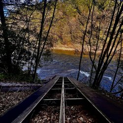
Came here via an article in Backpacker magazine and it wasn't worth the drive. Did a 12.7 mile loop through the park it was probably better for biking than hiking. The fossils areas didn't seem exciting. It was cool the see the highway be taken back by the earth. Over all if your in local it's with swinging by but I wouldn't go out of my way to visit this state park.

Well, we drove up and down Rt 443 several times looking for the address that is listed on here, however we never found it. I suggest you look for Trout Run and park there. Hiking is ok, maybe cause I was already frustrated with trying to find the place. We finally parked at Trout Run trailhead. There is parking lot, one picnic table and two bathrooms (port a potty). The bridge was out of service due to flood damage. The Appalachian Trail runs here, but overgrown most of the way -which is understandable since most hikers won't hike in middle of summer. Walked out of there with no ticks! Touchdown!!!

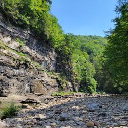
Went to Swatara State Park today for the first time and was really impressed! We went looking for the Aygriggs waterfall but went in with no planning so initially had a hard time finding where to park. (I wonder if the other reviewers with lower ratings for the park also struggled to find where exactly to go, because once you actually find it, it's actually so gorgeous). The place Apple Maps led us to had no parking and was just the park entrance with a bunch of roadway (there is no visitor center). We then incorrectly turned into the parking lot for the Trout Run trail at one point-- which has the rugged trout run path and Appalachian path (hard hikes, no waterfall) but did have two outhouse style bathrooms. On our third or fourth try (we tried mapping it to the cabin unsuccessfully) we finally found the scenic trail. If you're like us, and want to see a scenic hike, I would highly recommend the Bordner's Cabin Trail -- it's about 3.1 miles (1.5h walk) roundtrip-- it has an easy gravel path to the gorgeous and elusive Aygriggs waterfall! To get there, I would recommend getting the AllTrails app which is helpful to tell you where to park exactly. If you want to get to Bordner's cabin parking lot you need to route your Apple or Google Maps to coordinates: 40.50403° N, 76.51133° W. From there you can find the trail head and walk to the waterfall. It took us about 30-45 min to walk there, and another 30-45 min to walk back to our car. The waterfall is gorgeous and the way there you cross over a bridge over Swatara creek. Right next to the waterfall there is Bordner's cabin (hence the trail name) which overlooks the waterfall. It has tables and benches inside so you could even bring a picnic and sit under the cabin roof if you wanted to stay for a bit. We came across many bikers on the path (there even were signs for horses to walk on the left side of the trail) so the terrain wasn't too rugged. read more


Fantastic trail for families. Nice smooth paved pathway for strollers. So bring the kids, dogs and anybody else that wants a nice 3 mile walking trail to go on. There is a more strenuous hiking trail for those looking to burn some calories. Lots of wildlife and a great opportunity to find some very rare American chestnut trees!! Both chestnut trees I found have been reported to PA/NJ Chapter of the American Chestnut Foundation. Picnic tables located at Bordner Cabin if you wanna bring lunch and hang out. Highly recommend this trail for the entire family. read more


 - Hiking Near Me - Pine Grove, Pennsylvania")
2 years ago
I came here to mountain bike the single track trails and had a great time even though I was riding alone. The scenery and wildlife are lovely and the trails are well maintained. I took my time and stopped to take some pictures. There are several little stream crossings and a few smallish log overs plus a decent amount of roots. Just a few very small drops. What would make this ride better? A porta potty at the trail head. That being said, there is a bike station with an air pump and bike tools at the trail head as well as a map. The trails are all marked really well so you won't get lost. You have cell service on all the single track trails so you can track your route with Strava or Trailforks or whatever. I only ran into a few other bikers on a summer Saturday and they were all friendly and considerate. Happy trails! read more


Came here via an article in Backpacker magazine and it wasn't worth the drive. Did a 12.7 mile loop through the park it was probably better for biking than hiking. The fossils areas didn't seem exciting. It was cool the see the highway be taken back by the earth. Over all if your in local it's with swinging by but I wouldn't go out of my way to visit this state park. read more


9 years ago
Well, we drove up and down Rt 443 several times looking for the address that is listed on here, however we never found it. I suggest you look for Trout Run and park there. Hiking is ok, maybe cause I was already frustrated with trying to find the place. We finally parked at Trout Run trailhead. There is parking lot, one picnic table and two bathrooms (port a potty). The bridge was out of service due to flood damage. The Appalachian Trail runs here, but overgrown most of the way -which is understandable since most hikers won't hike in middle of summer. Walked out of there with no ticks! Touchdown!!! read more


Swatara State Park is a 3500 acre undeveloped tract of land, sitting just north of I-81 in the Pine grove area. It contains the historic Waterville Bridge, which carries the Appalachian trail through the area. There is an access road and its great for spotting wildlife & picking blackberries in the summer. However many activites are limited, no concession stand, limited cellphone use, no park office. read more


More info about Swatara State Park
Ask the Community - Swatara State Park


Swatara State Park - hiking - Updated July 2026
Best of Pine Grove
People found Swatara State Park by searching for…
Hiking Trails With Waterfalls in Pine Grove, Pennsylvania
Things to Do in Pine Grove, Pennsylvania
Places to Take Pictures in Pine Grove, Pennsylvania
Running Track in Pine Grove, Pennsylvania
Mountain Bike Trails in Pine Grove, Pennsylvania
Waterfalls in Pine Grove, Pennsylvania
Dog Friendly Hiking Trails in Pine Grove, Pennsylvania
Walking Trails in Pine Grove, Pennsylvania
Dog Swimming in Pine Grove, Pennsylvania
Picnic Areas in Pine Grove, Pennsylvania
Dinosaur Park in Pine Grove, Pennsylvania
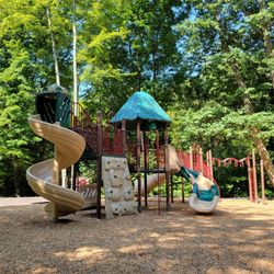
Playgrounds in Pine Grove, Pennsylvania
State Parks Camping in Pine Grove, Pennsylvania
Waterfalls and Swimming Holes in Pine Grove, Pennsylvania
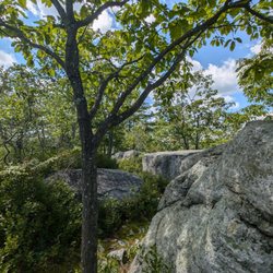
Scenic Overlook in Pine Grove, Pennsylvania
Scenic Views in Pine Grove, Pennsylvania
Picnic Spots in Pine Grove, Pennsylvania
Off Road Trails in Pine Grove, Pennsylvania
Parks for Picnics in Pine Grove, Pennsylvania
Photo Spots in Pine Grove, Pennsylvania
Things to Do on a Rainy Day in Pine Grove, Pennsylvania
Off Leash Dog Hiking Trails in Pine Grove, Pennsylvania