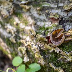
Sugarloaf Open Space Photos


You might also consider
More like Sugarloaf Open Space
Recommended Reviews - Sugarloaf Open Space
Start your review...

Reviews With Photos

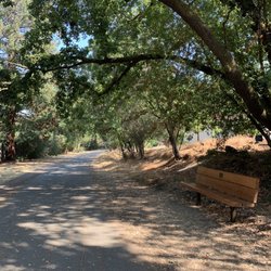
We were in Walnut Creek for the afternoon and wanted a place to eat lunch outdoors. This sounded like a promising location and it was great! Tucked away off the main roads, the picnic area was pleasant and not crowded. People were hiking on the surrounding trails and very well behaved squirrels scampered about.

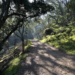
In 1974, Walnut Creek residents passed a measure to protect some of its open space for future recreation. If they hadn't done that, then Sugarloaf would be filled with McMansions. Instead, this former walnut orchard is a medium-sized preserve where you can get a breather. Or really exercise and get out of breath. It's not the great adventure that Shell Ridge is, but it's good enough. It doesn't take much to see it all. It's the workout, views, and break from the normal routine that count. Trails go up to the top of the ridge, where you have a gorgeous view of I-680 traffic. Turn around, though, and you have a better view of the city and Mt. Diablo. Sugarloaf has more amenities that add value. Next to the large parking lot is a large picnic area, which works well for 50 people. Surprisingly, you can also camp here, just make a reservation with the Parks & Rec office. Amphitheater that's rarely used. Be warned that there's little shade when you get beyond the walnut trees. Water is never far away, but be prepared. Enjoy yourself. read more


Sugarloaf Open Space was mentioned in a prior review as being one of "Walnut Creek's best kept secrets". I can agree with that HALF-heartedly; yes, it's very secluded and it's not a well known open space. However, it doesn't offer much as far as scenic views are concerned. There are a few decent views of other trails on the hills and Mount Diablo, but other than that... the only other thing that one might call "exciting" about this trail is that you can see the 680 freeway. Not sure about you, but that's not all that exciting to me. What Sugarloaf DOES offer is a mix of great short but heart pumping trails that will work those gluties. I started off on the Ridge top trail which began with a small but steady incline. The whole trail is a mix of hills that go up and down, but it's nothing strenuous. Those hills will get you though, and soon you will feel it all throughout your legs and backside. What made it a little more challenging for me was the high heat and minimal shade along the trails. I would recommend coming in the early morning to beat the heat because it will definitely slow you down. And with minimal shade, you will be making a few more water stops than usual. There are a few benches along the way, but they are few and far between. The Ridge Top Trail is a little over a mile long and ends behind the back of a residence. You'll reach the end when you see a gate and a private residence trail. Ridge Top intersects with many other small trails, most of which will take you back down to the entrance. I wanted to continue the hike and decided to take the Bottom Spring trail. The trail will take you along side the 680 freeway and it also ends behind a residential area. Warning: only about 1/3 of this trail is actually fully paved. The rest of it consists of very uneven terrain! I would suggest wearing good shoes for ankle support if you choose to hike this trail. However, I have to add that it was really quite boring... nothing really to see except for the 680 freeway. I wouldn't recommend taking the Bottom Spring trail unless you really want to explore, but it was really annoying because I had to slow my speed to watch where I stepped. One fun observation though, were all of the dragon flies that I saw. I must have seen about 20 of them roaming around and it was really neat. I didn't see the Sugarloaf to Shell Ridge trail until after I was done hiking, but that trail is probably way more exciting that the others that I tried. Overall, it's decent and there weren't many people at all on this trail... I'm talking only TWO other people, and one guy wasn't even hiking; he was just chilling on the bench. If you like super secluded trails, then this one might be for you. I would be open to coming back to hike the Sugarloaf to Shell Ridge trail, but otherwise I think I'll choose local options before Sugarloaf. read more


5 years ago
We were in Walnut Creek for the afternoon and wanted a place to eat lunch outdoors. This sounded like a promising location and it was great! Tucked away off the main roads, the picnic area was pleasant and not crowded. People were hiking on the surrounding trails and very well behaved squirrels scampered about. read more


5 years ago
7 years ago
13 years ago
12 years ago
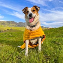
Beautiful, picturesque, relatively solitary and I hardly ever see people when I go. I bring my dogs here, once you get past the gate at the top of the hill the trail starts and off leash privileges. Walnut creek's best kept secret. read more


14 years ago
12 years ago
More info about Sugarloaf Open Space
Ask the Community - Sugarloaf Open Space
You might also consider


Sugarloaf Open Space - hiking - Updated July 2026
Best of Walnut Creek
People found Sugarloaf Open Space by searching for…
Campgrounds in Walnut Creek, California
Parks in Walnut Creek, California
Scenic View in Walnut Creek, California
Hiking Trails in Walnut Creek, California
Walking Trails in Walnut Creek, California
Scenic Drive in Walnut Creek, California
Sunset Views in Walnut Creek, California
Parks for Kids in Walnut Creek, California
Picnic Spots in Walnut Creek, California
Views in Walnut Creek, California
Off Leash Dog Hiking Trails in Walnut Creek, California
Walking Groups in Walnut Creek, California
Kid Friendly Hiking Trails in Walnut Creek, California
Running Trails in Walnut Creek, California
Shaded Hike in Walnut Creek, California
Night View in Walnut Creek, California
Night Hike in Walnut Creek, California
Watch Sunset in Walnut Creek, California
Easy Hikes in Walnut Creek, California
Fall Foliage in Walnut Creek, California
Secluded Spots in Walnut Creek, California
Picnic Areas in Walnut Creek, California
Trending Searches in Walnut Creek, CA
4th Of July Fireworks in Walnut Creek, CA
Black Owned Nail Salons in Walnut Creek, CA
Boat Rental in Walnut Creek, CA
Cliff Jumping in Walnut Creek, CA
Dog Friendly Trails in Walnut Creek, CA
Jet Ski Rental in Walnut Creek, CA
Kayak Rental in Walnut Creek, CA
Lakes & Ponds in Walnut Creek, CA
Outdoor Activities in Walnut Creek, CA
Places To Walk Around in Walnut Creek, CA
Public Pools in Walnut Creek, CA
Public Shower in Walnut Creek, CA
Rock Quarry in Walnut Creek, CA
Running Trails in Walnut Creek, CA
Scenic Night View in Walnut Creek, CA
Scenic Overlook in Walnut Creek, CA
Secluded Spots in Walnut Creek, CA
Soccer Store in Walnut Creek, CA
Splash Pad in Walnut Creek, CA
Strawberry Picking in Walnut Creek, CA
Sunrise View in Walnut Creek, CA
Swimming Holes in Walnut Creek, CA
Swimming Lakes in Walnut Creek, CA
Swimming Pools in Walnut Creek, CA
Watch Sunset in Walnut Creek, CA
Browse Articles
Browse Nearby
BEST of Walnut Creek, California Restaurants near Sugarloaf Open Space
BEST of Walnut Creek, California Coffee near Sugarloaf Open Space
BEST of Walnut Creek, California Things to Do near Sugarloaf Open Space
BEST of Walnut Creek, California Beaches near Sugarloaf Open Space
BEST of Walnut Creek, California Parks near Sugarloaf Open Space
BEST of Walnut Creek, California Campgrounds near Sugarloaf Open Space
BEST of Walnut Creek, California Breakfast near Sugarloaf Open Space
BEST of Walnut Creek, California Lodging near Sugarloaf Open Space
BEST of Walnut Creek, California Motel near Sugarloaf Open Space
Browse Brands
Related Searches in Walnut Creek, CA
Affordable Kayak Rental Services in Walnut Creek, California
Best Fishing Locations and Guides in Walnut Creek, California
Best Nature Trails for Hiking in Walnut Creek, California
Best Places for Horseback Riding in Walnut Creek, California
Check Out Off Road Trails in Walnut Creek, California
Discover Dog Friendly Trails to Explore in Walnut Creek, California
Discover Kid Friendly Hiking Trails in Walnut Creek, California
Discover Scenic Hiking Trails in Walnut Creek, California
Discover Scenic Mountain Bike Trails Near Walnut Creek, California
Discover Scenic Waterfall Spots in Walnut Creek, California
Discover Walking Parks in Walnut Creek, California Near You
Discover a Hiking Trail in Walnut Creek, California
Discover the Best Night Hike Trails in Walnut Creek, California
Discover the Best Running Track in Walnut Creek, California
Dog-Friendly Hikes With Dogs in Walnut Creek, California
Enjoy Camping Adventures Around Walnut Creek, California
Enjoy Kayaking Adventures in Walnut Creek, California
Enjoy Tent Camping Spots Around Walnut Creek, California
Enjoy a Beautiful Waterfall Hike in Walnut Creek, California
Enjoy a Peaceful Nature Walk in Walnut Creek, California
Enjoy the Best Picnic Spots and Ideas in Walnut Creek, California
Enjoy the Best Walking Path in Walnut Creek, California
Enjoy the Best Walking Trails in Walnut Creek, California
Explore Beautiful Parks and Green Spaces in Walnut Creek, California
Explore Easy Hikes Perfect for All in Walnut Creek, California
Explore Fun Activities to Do in Walnut Creek, California
Explore Popular Campgrounds Near Walnut Creek, California
Explore the Best Beach Spots in Walnut Creek, California
Explore the Best Swimming Holes Around Walnut Creek, California
Explore the Best Trail Options in Walnut Creek, California
Family Friendly Hiking With Kids in Walnut Creek, California
Find Beautiful Views in Walnut Creek, California
Find the Best Parks for Picnics in Walnut Creek, California
Find the Best Scenic View Locations in Walnut Creek, California
Great Places to Walk in Walnut Creek, California
Hike the Popular Waterfall Trail in Walnut Creek, California
Hiking Trails With Waterfalls in Walnut Creek, California
Off Leash Dog Hiking Trails in Walnut Creek, California
Plan a Scenic Drive Route Near Walnut Creek, California
Popular Outdoor Activities to Try in Walnut Creek, California
Popular Picnic Spots to Visit in Walnut Creek, California
Safe River Swimming Areas in Walnut Creek, California
Safe and Fun Parks for Kids in Walnut Creek, California
Top Climbing Spots and Gyms in Walnut Creek, California
Top Paddleboarding Activities in Walnut Creek, California
Top Running Trails to Explore in Walnut Creek, California
Top Swimming Lakes to Enjoy in Walnut Creek, California
Top Swimming Spots and Pools in Walnut Creek, California
Walk Dog Friendly Hiking Trails in Walnut Creek, California
Walk the Best Paved Walking Trails in Walnut Creek, California
People who viewed Sugarloaf Open Space also viewed
Old Borges Ranch
30 reviews
Shell Ridge Open Space
62 reviews
Hidden Lakes Park
56 reviews
Waterfall Loop at Mount Diablo State Park
33 reviews
Castle Rock Park Operations
2 reviews
Iron Horse Trail
47 reviews
Len Hester Park
10 reviews
Rohrer Ridge Trail
2 reviews
Mt Diablo Summit
89 reviews
Mount Diablo's Grand Loop
6 reviews