Stonewall Peak Half Marathon Photos


You might also consider
More like Stonewall Peak Half Marathon
Recommended Reviews - Stonewall Peak Half Marathon
Start your review...

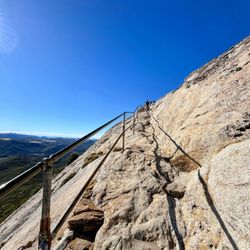
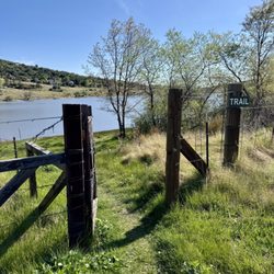
I'm an avid runner who loves big races because I enjoy leaving people in my dust! Yah I get passed up sometimes, but they don't count because they have better genes than me, or their shoes are lighter, or my dog ate my homework, or whatever excuse I have that day. Anyways, road races are my niche but something about trail running had me curious so I signed up for the Stonewall Peak Half Marathon for only $45 (hooyah military discount). After taking a glance at the course map I noticed that it only had one aid station around mile 6 and that we'd be climbing two peaks during the half. The race director went further to ensure everyone brought at least 50 oz of water with us because of the heat that Cuyumaca had been experiencing. All that info was great but I was pretty naive on trail running and I rarely trained in dirt thinking that I'd finish in a time close to my normal road runs. Boy was that dumb and I paid for it dearly. I drove to the race with blind confidence thinking I was going to smash this thang! NOPE, this thing kicked my ass! I was immediately humbled when I started my ascent up Stonewall Peak trying to maintain my pace and keep up with a few ultra runners. After ten minutes or so I saw some of them walking and that's when I knew that this race would take a lot longer than I expected and that I had better watch my water and electrolyte intake. Going up the first peak at a jog for a minute and walk for two worked out well but for Middle peak that didn't last. At that time of the day I had already taken my sweat soaked hat and the sun was puffing out it's chest with all it's might. My quads were gone and it actually took effort and mind control to keep crawling up the mountain but when I hit the fire road and saw that it was the start of the descent, that's when I pushed through the wall and found that little bit of reserved strength to finish the race strong. After wards, I downed two cokes and damn near passed out and vomited. I barely had the awareness to drive the hour long ride home but after I took my ten hour nap I knew that I had left everything in Cuyumaca and I had found my new beast to tame. This run was nothing like I've ever experienced before and with only 80 people running 13 plus miles I only saw a handful of runners, so this race was truly mind vs body. The sights were awe inspiring and the pictures are memorable but my favorite souvenir from the race was my sore and exhausted body. read more


More info about Stonewall Peak Half Marathon
12551 Hwy 79
Descanso, CA 91916
Directions
Hours
Outdoor Amenities
You might also consider


Stonewall Peak Half Marathon - races - Updated May 2026
Best of Descanso
People found Stonewall Peak Half Marathon by searching for…
Trending Searches in Descanso, CA
Botanical Gardens near Stonewall Peak Half Marathon
Bounce House Rentals near Stonewall Peak Half Marathon
Campgrounds near Stonewall Peak Half Marathon
Cheap Plants near Stonewall Peak Half Marathon
Cherry Picking near Stonewall Peak Half Marathon
Flower Shop near Stonewall Peak Half Marathon
Garage Sales near Stonewall Peak Half Marathon
Garden Center near Stonewall Peak Half Marathon
Nurseries & Gardening near Stonewall Peak Half Marathon
Outdoor Furniture Stores near Stonewall Peak Half Marathon
Party Equipment Rentals near Stonewall Peak Half Marathon
Pedicure near Stonewall Peak Half Marathon
Rv Rental near Stonewall Peak Half Marathon
Browse Articles
Browse Nearby
BEST of Descanso, California Coffee near Stonewall Peak Half Marathon
BEST of Descanso, California Restaurants near Stonewall Peak Half Marathon
BEST of Descanso, California Things to Do near Stonewall Peak Half Marathon
BEST of Descanso, California Breakfast near Stonewall Peak Half Marathon
BEST of Descanso, California Camping near Stonewall Peak Half Marathon
Browse Brands
Related Searches in Descanso, CA
Best Fun Things to Do in Descanso, California
Best Tailgate Food Options Available in Descanso, California
Best Things to Do With Teens in Descanso, California
Browse Running Shoe Stores Around Descanso, California
Challenge Yourself With an Obstacle Course in Descanso, California
Corporate Team Building Activities in Descanso, California
Dirt Bike Rental Services Available in Descanso, California
Discover the Best Running Track in Descanso, California
Enjoy Exciting Kids Amusement in Descanso, California
Exciting Motocross Events and Tracks in Descanso, California
Experience Exciting Horse Racing in Descanso, California
Experience the Best Simulator Centers in Descanso, California
Explore Exciting Theme Parks in Descanso, California
Explore Motorcycle Classes Available in Descanso, California
Explore Popular Running Routes in Descanso, California
Explore the Best Go Karts Available in Descanso, California
Explore the Best Motorcycle Track Locations in Descanso, California
Find Exciting Bumper Cars Attractions in Descanso, California
Find Exciting Indoor Fun Activities in Descanso, California Today
Find Fun Things to Do at Night With Kids in Descanso, California
Find Top Family Entertainment Options in Descanso, California
Find a Trusted Running Coach in Descanso, California
Find the Best Fireworks Shows in Descanso, California
Find the Best Horse Race Track in Descanso, California
Fun Laser Tag for Kids Available in Descanso, California
Fun Train Rides for Kids in Descanso, California
Fun Video Game Arcade Locations in Descanso, California
Get Professional Triathlon Training in Descanso, California
Great Things to Do Indoors in Descanso, California
Host Your Perfect Teen Party in Descanso, California
Join Exciting Triathlon Events in Descanso, California
Plan a Teen Birthday Party in Descanso, California
Play Indoor Mini Golf Courses in Descanso, California
Play Mario Kart Events and Venues in Descanso, California
Play at Family Fun Arcades in Descanso, California With Kids
Popular Ferris Wheel Attractions in Descanso, California
Popular Running Routes to Try in Descanso, California
Popular Things to Do in Descanso, California
Race Cars Fun for Kids Activities in Descanso, California
Ride at the BMX Track in Descanso, California
Thrilling Car Racing Events in Descanso, California
Thrilling Go Kart Racing Experiences in Descanso, California
Top Claw Machine Arcades Near Descanso, California
Top Driving Schools Available in Descanso, California
Top Family Fun Activities to Try in Descanso, California Today
Top Indoor Amusement Parks in Descanso, California
Top Running Trails to Explore in Descanso, California
Upcoming Carnivals Happening in Descanso, California
People who viewed Stonewall Peak Half Marathon also viewed
Azalea Glen Loop Trail
2 reviews
Stonewall Peak
1 review
Santa Ysabel Open Space Preserve West
13 reviews
Kids Obstacle Challenge
1 review
Ramona Oaks Shade Trail
1 review
Horse of the Sun Ranch
4 reviews
Laguna Mountain Recreation Area
26 reviews
Cheetah Run
7 reviews
Butterfly Jungle
6 reviews
Polar Bear Swim Club
1 review