Soledad Canyon Loop Photos


More like Soledad Canyon Loop
Recommended Reviews - Soledad Canyon Loop
Start your review...

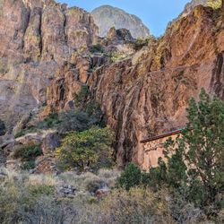
Great Saturday morning hike. We went out pretty early, so there was lots of shade. Saw a lot of wildlife - javelina and lots of deer. There was also quite a few beetles, but they're little harmless bugs. It's a gradual elevation gain, so even if you're not in the best shape (like me), it is very doable. Just have enough water. We were also treated to the old ruins, some beautiful rock formations and best of all, the waterfall was trickling! The return back to the parking lot is pretty much all downhill. read more


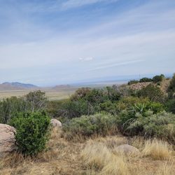
This is a great, easy hike to a beautiful waterfall with a loop trail through the hills and grasslands which were full of wildflowers in early October. There is little shade except for the waterfall so go early. Be sure and take at least a portion of the northern Bar Canyon trail to the ruins as well. The Bar Canyon loop trail was a bit confusing due to the number of social trails so watch closely for the signs. read more


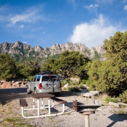
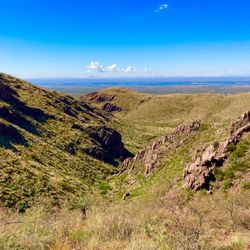
More and more I'm starting to prefer the Organ Mountain over the Franklin Mountains for hiking. Even for a three star trail, Soledad Canyon Loop is one of my favorite hikes we've done in the area. Finding Soledad Canyon Loop proved to be a bit difficult as it seems is the norm for a lot of trails in Las Cruces. We did a lot of research and found a website that gave a pin drop location which ended up leading us exactly where we needed to go. Right now the pinned location on Yelp should lead you right to the parking lot at the Loop, but if it doesn't just GPS Soledad Canyon Road and follow it until it ends. Before you get to Soledad Canyon Road you should pass a sign that says you're heading towards Dripping Springs... you're on the right track. They're a few miles apart (and on different roads), but you're in the general vicinity. SCL doesn't have a visitors office or anything really other than a parking lot and the loop map at the start of the trail. On the upside, that means it's a free trail! On the downside, don't hike alone unless someone knows you're out there. Musts: sun block, bug spray, and water. Most of the trail we were exposed to the elements, but we went around 8am on a cloudy day so we weren't really warming up until we were almost done with our hike. What really drew us to this hike was the promise of a waterfall at the top. In this area waterfalls tend to be small, but they're usually running well in the early spring and after a rainfall. We had just had a lot of rain the previous day so we thought it would be flowing... well when we got to the top it wasn't really flowing, but more dripping periodically. However, we found out that if you climb up the side of the hill (there's a steep trail that goes most of the way) there is much more water up there. We had two of our pups with us so we decided not to so we may never know how beautiful the top truly was. The trail itself is a mix of dirt and broken rocks. It's a steady incline, but a fairly short and easy trail. I think we were out there for maybe an hour and a half round-trip (including a long stop at the waterfall). The rocks are smaller, but didn't do any damage to our dogs paws. I do wish they put up signs while you're on the trail because there are a couple of parts that branch off so it can be a teeny bit confusing and the waterfall itself isn't actually on the loop, it a maybe quarter mile branch off of the loop. It isn't too hard to spot though because you'll notice a ton more green vegetation than you've seen anywhere else on the trail. While we were hiking we talked to some other hikers and I will say everyone on the trails in the Organ Mountains tend to be really nice. People say "good morning" and are always eager to give recommendations on other similar trails if you ask. Being from El Paso we're pretty close by, but we don't have the same working knowledge of all the awesome trails out here so it's nice to be able to pick some fellow hiker's brains. read more
 - Hiking Near Me - Las Cruces, New Mexico")


My boyfriend took me here and I chickened out once we got to climbing some rocks but I feel you have to be some type of expert to do this. Not exactly , I'm just a big baby and scared of heights and the rocks were pretty steep. So I wasn't able to see the other side of the water fall and jump into the water. Boo boo! Next time, I shall be trained to climb first. But the walk isn't so bad, about 25min or so. They have interesting bugs you run into while you hike. Found some scorpions, all kinds of flying things and grasshoppers. The view is amazing. Desert life definitely. A little different than what I'm use to which is back home in California. You don't want to go when it's too hot. Not much shade until you get to the end, which you'll see a mini waterfall but its not always a guarantee. It was around 80 degrees so it wasn't too bad. Make sure to pack a lot of snacks and water ! read more


More info about Soledad Canyon Loop
Soledad Canyon Rd
Las Cruces, NM 88011
Directions
Hours
Indoor Amenities
Outdoor Amenities


Soledad Canyon Loop - hiking - Updated May 2026
Best of Las Cruces
People found Soledad Canyon Loop by searching for…
Natural Hot Springs in Las Cruces, New Mexico
Things to Do in Las Cruces, New Mexico
Scenic View in Las Cruces, New Mexico
Walking Trails in Las Cruces, New Mexico
Dog Friendly Hiking Trails in Las Cruces, New Mexico
Tours in Las Cruces, New Mexico
Running Trails in Las Cruces, New Mexico
Waterfalls in Las Cruces, New Mexico
Beautiful Views in Las Cruces, New Mexico
Off Road Trails in Las Cruces, New Mexico
Fun Places to Go in Las Cruces, New Mexico
Trail in Las Cruces, New Mexico
Dog Friendly in Las Cruces, New Mexico
Easy Hikes in Las Cruces, New Mexico
Tourist Attractions in Las Cruces, New Mexico
Things to Do at Night in Las Cruces, New Mexico
Night Hike in Las Cruces, New Mexico
To Do in Las Cruces, New Mexico
Waterfalls and Swimming Holes in Las Cruces, New Mexico
Photo Spots in Las Cruces, New Mexico
Hiking Trails With Waterfalls in Las Cruces, New Mexico
Dog Friendly Things to Do in Las Cruces, New Mexico
Trending Searches in Las Cruces, NM
Bounce House Rentals near Soledad Canyon Loop
Campgrounds near Soledad Canyon Loop
Floral Designers near Soledad Canyon Loop
Florists That Deliver near Soledad Canyon Loop
Flower Shop near Soledad Canyon Loop
Garage Sales near Soledad Canyon Loop
Garden Center near Soledad Canyon Loop
Golf Lessons near Soledad Canyon Loop
Lakes & Ponds near Soledad Canyon Loop
Mens Suits near Soledad Canyon Loop
Nurseries & Gardening near Soledad Canyon Loop
Outdoor Furniture Stores near Soledad Canyon Loop
Parks near Soledad Canyon Loop
Party Equipment Rentals near Soledad Canyon Loop
Pedicure near Soledad Canyon Loop
Photo Spots near Soledad Canyon Loop
Picnic Areas near Soledad Canyon Loop
Places To Take Pictures near Soledad Canyon Loop
Plant Nursery near Soledad Canyon Loop
Rock Quarry near Soledad Canyon Loop
Running Trails near Soledad Canyon Loop
Scenic Drive near Soledad Canyon Loop
Scenic Night View near Soledad Canyon Loop
Browse Articles
Browse Nearby
Browse Brands
Related Searches in Las Cruces, NM
Best Fishing Locations and Guides in Las Cruces, New Mexico
Best Fun Things to Do in Las Cruces, New Mexico
Best Places for Horseback Riding in Las Cruces, New Mexico
Discover Dog Friendly Trails to Explore in Las Cruces, New Mexico
Discover Lakes & Ponds to Explore in Las Cruces, New Mexico
Discover Popular Photo Spots in Las Cruces, New Mexico
Discover a Hiking Trail in Las Cruces, New Mexico
Discover the Best Night Hike Trails in Las Cruces, New Mexico
Dog-Friendly Hikes With Dogs in Las Cruces, New Mexico
Enjoy Camping Adventures Around Las Cruces, New Mexico
Enjoy Exciting Mountain Biking Adventures in Las Cruces, New Mexico
Enjoy Scenic Night View Experiences in Las Cruces, New Mexico
Enjoy Tent Camping Spots Around Las Cruces, New Mexico
Enjoy the Best Night View Spots in Las Cruces, New Mexico
Enjoy the Best Tubing Experiences in Las Cruces, New Mexico
Enjoy the Best Walking Trails in Las Cruces, New Mexico
Experience Stunning Sunset Views in Las Cruces, New Mexico
Explore Beautiful Parks and Green Spaces in Las Cruces, New Mexico
Explore Easy Hikes Perfect for All in Las Cruces, New Mexico
Explore Free Things to Do Around Las Cruces, New Mexico
Explore Fun Activities to Do in Las Cruces, New Mexico
Explore Popular Campgrounds Near Las Cruces, New Mexico
Explore Popular RV Parks Around Las Cruces, New Mexico
Explore Scenic Lakes to Visit in Las Cruces, New Mexico
Explore Top Dog Parks in Las Cruces, New Mexico Near You
Explore the Best Boating Spots in Las Cruces, New Mexico
Family Friendly Hiking With Kids in Las Cruces, New Mexico
Find Beautiful Views in Las Cruces, New Mexico
Find Top Dog Swimming Spots in Las Cruces, New Mexico
Find Top Skate Parks in Las Cruces, New Mexico for All Skill Levels
Find the Best Parks for Picnics in Las Cruces, New Mexico
Find the Best Playgrounds to Visit in Las Cruces, New Mexico
Find the Best Scenic View Locations in Las Cruces, New Mexico
Find the Best Swimming Pools in Las Cruces, New Mexico Today
Fun Toddler Activities to Try in Las Cruces, New Mexico
Locate Tennis Courts Around Las Cruces, New Mexico
Must-See Tourist Attractions Around Las Cruces, New Mexico
Plan a Scenic Drive Route Near Las Cruces, New Mexico
Popular Fishing Spots to Explore in Las Cruces, New Mexico
Popular Kids Activities in Las Cruces, New Mexico
Popular Picnic Spots to Visit in Las Cruces, New Mexico
Popular Things to Do in Las Cruces, New Mexico
Popular Things to See in Las Cruces, New Mexico
Relax at Natural Hot Springs Near Las Cruces, New Mexico
Safe and Fun Parks for Kids in Las Cruces, New Mexico
Top Playgrounds for Kids to Enjoy in Las Cruces, New Mexico
Top Running Trails to Explore in Las Cruces, New Mexico
Top Swimming Spots and Pools in Las Cruces, New Mexico
People who viewed Soledad Canyon Loop also viewed
Dripping Springs Natural Area
27 reviews
Aguirre Springs
6 reviews
Tortugas Mountain Trail
4 reviews
Organ Mountains Desert Peaks National Monument
6 reviews
Las Cruces Dam Trail
3 reviews
Mesilla Valley Bosque State Park
4 reviews
La Llorona Park
3 reviews
Four Hills Park
1 review
Apodaca Park
3 reviews
Mesilla Valley Maze
14 reviews