Soapstone Mountain Photos


You might also consider
More like Soapstone Mountain
Recommended Reviews - Soapstone Mountain
Start your review...

Reviews With Photos

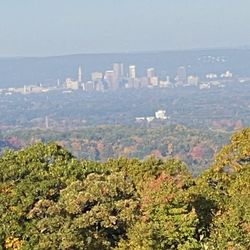
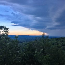
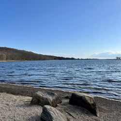
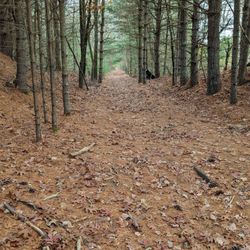
A 2 mile point-to-point trail, Soapstone Mountain stands in the southeast corner of the of Somers. Bordering the town lines Ellington, Stafford, and Somers join -- it's great for all skill-types. The first .5 mile on pavement up to the observation tower can be a real ass-kicker depending on how ambitious/hardcore you are -- otherwise it's a fairly easy walk. There are several other trails up also. Immediately to the right of the parking lot is the Shenipsit Trail. Its blue-blazed and is another .5 mile ascent to the top. It starts off as a minute-long flat-terrain walk before becoming a very steep climb. My friends and I love/hate it. We jokingly call it "suicide hill" but it can be a real ass-kicker for beginners or the uninitiated. There are picnic areas along the road up to the tower, as well as an outdoor toilet at the top parking lot. Various forest trails can be used for hiking, mountain biking, horse-back riding, and cross-country skiing too. At the peak, the mountain is 1,075 feet and its views extend over Connecticut to the mountains of New Hampshire and Vermont in clear weather. The views can't be beat on a clear day. Soapstone has to be one of favorites because it's really the only public mountaintop that has an observation tower east of the Connecticut River.

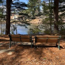
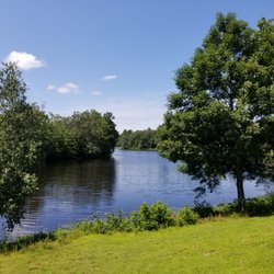
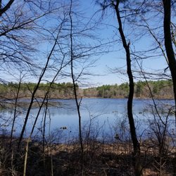
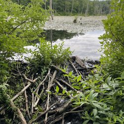
Miles of hiking trails, paved and graveled mountain roads, and scenic overlooks whichever way you ascend, this is a perfect spot for a quiet weekend getaway, Even on a Sunday morning around peak Autumn foliage you can find many scenic spots no else already found. This can be a quick drive kind of spot or a great morning hike as trails to beaver ponds, glacial erratics, and picnic tables are all within a short distance of the forest roads. The fire tower was out of commission for years but has happily been restored, and interpretive signs at the top show each visible peak including, Mt. Tom and Mt. Monadnock among them, on clear enough days. The only facilities are a port-o-let at the bottom of Soapstone Road, so plan accordingly if you don't want to make the ten minute trip back down to Ellington. read more


7 years ago
Great views, easy hike through the woods, or up the paved access road, or drive up if you prefer! Awesome local option for some nice views. Tips: Bring lunch if the weather is nice, there are picnic tables everywhere. DON'T MISS THE TOWER. It was repaired (major overhaul) recently and reopened to the public. Can't see it from the end of the access road, but it's an incredibly short walk from there. Go up toward and around the chain fence. read more

4 years ago
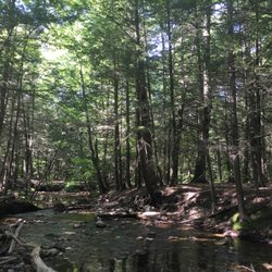
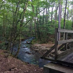
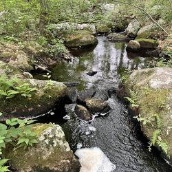
Great hike with quite the steep incline at the very beginning with a very rewarding view up top the tower. We took some trails less traveled and the AllTrails map came in handy several times. Cute water feature and bridge where we did some exploring off trail. Would hike again but take different routes to see what else is out there! Oh yeah- saw some bear poop too! read more


A 2 mile point-to-point trail, Soapstone Mountain stands in the southeast corner of the of Somers. Bordering the town lines Ellington, Stafford, and Somers join -- it's great for all skill-types. The first .5 mile on pavement up to the observation tower can be a real ass-kicker depending on how ambitious/hardcore you are -- otherwise it's a fairly easy walk. There are several other trails up also. Immediately to the right of the parking lot is the Shenipsit Trail. Its blue-blazed and is another .5 mile ascent to the top. It starts off as a minute-long flat-terrain walk before becoming a very steep climb. My friends and I love/hate it. We jokingly call it "suicide hill" but it can be a real ass-kicker for beginners or the uninitiated. There are picnic areas along the road up to the tower, as well as an outdoor toilet at the top parking lot. Various forest trails can be used for hiking, mountain biking, horse-back riding, and cross-country skiing too. At the peak, the mountain is 1,075 feet and its views extend over Connecticut to the mountains of New Hampshire and Vermont in clear weather. The views can't be beat on a clear day. Soapstone has to be one of favorites because it's really the only public mountaintop that has an observation tower east of the Connecticut River. read more


6 years ago
6 years ago


11 years ago
More info about Soapstone Mountain
Ask the Community - Soapstone Mountain
Review Highlights - Soapstone Mountain


Why does Yelp recommend reviews?
1 review that is not currently recommended
The reviews below are not factored into the business's overall star rating.
2 years ago
Soapstone Mountain - hiking - Updated June 2026
Best of Somers
People found Soapstone Mountain by searching for…
Trending Searches in Somers, CT
Amusement Parks near Soapstone Mountain
Beaches near Soapstone Mountain
Bike Trails near Soapstone Mountain
Black Owned Nail Salons near Soapstone Mountain
Boat Rental near Soapstone Mountain
Cliff Jumping near Soapstone Mountain
Dog Friendly Trails near Soapstone Mountain
Fishing Spots near Soapstone Mountain
Free Kids Activities near Soapstone Mountain
Jet Ski Rental near Soapstone Mountain
Outdoor Activities near Soapstone Mountain
Pick Your Own Farms near Soapstone Mountain
Picnic Areas near Soapstone Mountain
Public Pools near Soapstone Mountain
Running Trails near Soapstone Mountain
Scenic Drive near Soapstone Mountain
Splash Pad near Soapstone Mountain
Star Gazing near Soapstone Mountain
Strawberry Picking near Soapstone Mountain
Swimming Holes near Soapstone Mountain
Swimming Lakes near Soapstone Mountain
Swimming Pools near Soapstone Mountain
Watch Sunset near Soapstone Mountain
Water Parks near Soapstone Mountain
Browse Articles
Browse Nearby
Browse Brands
Related Searches in Somers, CT
Affordable Bike Repair Services in Somers, Connecticut
Affordable Bike Tune Up Services in Somers, Connecticut
Affordable Kayak Rental Services in Somers, Connecticut
Best Dirt Bike Riding Spots in Somers, Connecticut
Best Fishing Locations and Guides in Somers, Connecticut
Best Fun Things to Do in Somers, Connecticut
Best Lookout Points to Visit in Somers, Connecticut
Best Nature Trails for Hiking in Somers, Connecticut
Best Places for Horseback Riding in Somers, Connecticut
Best Spots for Star Gazing in Somers, Connecticut
Best Waterfalls and Swimming Holes in Somers, Connecticut
Discover Popular Bike Trails in Somers, Connecticut
Discover Scenic Mountain Bike Trails Near Somers, Connecticut
Discover a Hiking Trail in Somers, Connecticut
Discover the Best Night Hike Trails in Somers, Connecticut
Discover the Best Running Track in Somers, Connecticut
Dog-Friendly Hikes With Dogs in Somers, Connecticut
Enjoy Exciting Mountain Biking Adventures in Somers, Connecticut
Enjoy Hiking Adventures in Somers, Connecticut
Enjoy the Best Tubing Experiences in Somers, Connecticut
Enjoy the Best Walking Trails in Somers, Connecticut
Exciting Cliff Jumping Spots in Somers, Connecticut
Experience Stunning Sunset Views in Somers, Connecticut
Explore BMX Bike Shops Near Somers, Connecticut
Explore Beautiful Parks and Green Spaces in Somers, Connecticut
Explore Bike Rentals Throughout Somers, Connecticut
Explore Easy Hikes Perfect for All in Somers, Connecticut
Explore Electric Bikes Available in Somers, Connecticut
Explore Free Things to Do Around Somers, Connecticut
Explore Popular Campgrounds Near Somers, Connecticut
Explore Popular RV Parks Around Somers, Connecticut
Explore Popular Scenic Overlook Points in Somers, Connecticut
Explore Popular View Points Around Somers, Connecticut
Explore Scenic Lakes to Visit in Somers, Connecticut
Explore Secret Spots Worth Visiting in Somers, Connecticut
Explore Top Dog Parks in Somers, Connecticut Near You
Explore the Best Boating Spots in Somers, Connecticut
Explore the Best Swimming Holes Around Somers, Connecticut
Explore the Best Trail Options in Somers, Connecticut
Explore the Scenic River in Somers, Connecticut
Family Friendly Hiking With Kids in Somers, Connecticut
Find Beautiful Views in Somers, Connecticut
Find Popular Ziplining Spots Around Somers, Connecticut
Find Top Mountain Bike Rental Options in Somers, Connecticut
Find Top-Rated Disc Golf in Somers, Connecticut
Find Top-Rated Waterfalls in Somers, Connecticut Now
Find a Fixed Gear Bike Shop in Somers, Connecticut
Find the Best Bikes Available in Somers, Connecticut
People who viewed Soapstone Mountain also viewed
Rice Nature Preserve
5 reviews
Campbell's Peaceful Valley Conservation Area
1 review
Mansfield Hollow State Park
5 reviews
Peaked Mountain
5 reviews
Riverside Park
8 reviews
North Meadows
Northwest Park & Nature Center
22 reviews
Laurel Marsh Trail
2 reviews
Sunrise Park
3 reviews
Belding Wildlife Management
4 reviews
Eagleville Preserve
1 review