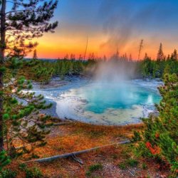
Sierra Point Photos


You might also consider
More like Sierra Point
Recommended Reviews - Sierra Point
Start your review...

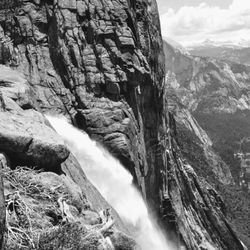
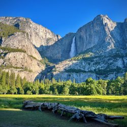
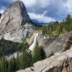
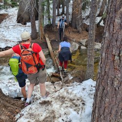
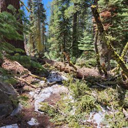
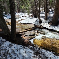
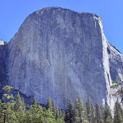
Sierra Point. The very spot in which Ansel Adams hiked to in 1916 at the age of 14 with his new Kodak 1 Brownie camera and took some of his very first pictures. It was this moment that inspired him to want to be a photographer and ultimately come back to Yosemite later in life and take some of the most recognized Yosemite pictures in the world. Talk about one historic spot. A little history on the trail itself. (Which is no longer in use due to a rockslide in the 70's but is still there...just not maintained.) "During the late 1800s early explorers were looking for an area that would view all five major waterfalls. On June 14, 1897 Charles A. Bailey and a friend located the area called Sierra Point by triangulation. This process is achieved by lining up three central points to locate any given area on a map. From this location one can view all five falls, Upper and Lower Yosemite, Illilouette, Vernal and Nevada Falls." I only found out about this spot through a friend who has been going to Yosemite for 30 years. You REALLY have to know where you are going to find the trail...its on older Yosemite Park maps, but because of the rockslide in the 70's the Rangers will not tell you where it starts and will advise you against doing the hike. It took me three times to finally make it all the way to the top, but that was because I had to find the old trail, (which took a couple attempts) and then take one full trip to make sure I had the time to get to the top. Its only an 800 foot climb over less than a mile, but you might lose the trail once or twice the first time so don't get discouraged. There is one spot about halfway up where the rockslide occurred and you have to do a bit of scrambling, but I have never ever climbed anything in my life and I was able to do it just fine. Just keep close watch were you step and you should be fine. Once at Sierra Point you are treated to one of the most amazing spots in all of Yosemite. To top it off, basically no one knows about this spot or how to get here so you almost feel like John Muir in that you feel like you have the whole park to yourself. (There are hundreds of people on the Mist Trail below you.) This trail isn't for everyone, but if you do enough research online and give yourself some time its totally something you can do. You won't regret it at all, its one of the most amazing hikes I have ever accomplished. :0) read more


 - Hiking Near Me - Yosemite Valley, California")


5 years ago
More info about Sierra Point
Yosemite Valley
Yosemite Valley, CA 95389
Directions
Visit Website
http://www.nps.gov/yose/
Hours
Outdoor Amenities


Sierra Point - hiking - Updated July 2026
Best of Yosemite Valley
People found Sierra Point by searching for…
Hiking Trails With Waterfalls in Yosemite Valley, California
Secret Spots in Yosemite Valley, California
Star Gazing in Yosemite Valley, California
Playgrounds in Yosemite Valley, California
Things to Do in Yosemite Valley, California
Camping With Showers in Yosemite Valley, California
Parks in Yosemite Valley, California
Picnic Areas in Yosemite Valley, California
Redwood Trees in Yosemite Valley, California
Lookout Points in Yosemite Valley, California
Stargazing in Yosemite Valley, California
Sunrise View in Yosemite Valley, California
Trails in Yosemite Valley, California
Caves in Yosemite Valley, California
Off Road Trails in Yosemite Valley, California
Waterfalls and Swimming Holes in Yosemite Valley, California
Swimming Lakes in Yosemite Valley, California
Natural Hot Springs in Yosemite Valley, California
Canyoneering in Yosemite Valley, California
View Points in Yosemite Valley, California
Places to Take Pictures in Yosemite Valley, California
Sunset View in Yosemite Valley, California
Trending Searches in Yosemite Valley, CA
Boat Rental in Yosemite Valley, CA
Cliff Jumping in Yosemite Valley, CA
Day Trips in Yosemite Valley, CA
Dog Friendly Beaches in Yosemite Valley, CA
Jet Ski Rental in Yosemite Valley, CA
Kayak Rental in Yosemite Valley, CA
Lakes & Ponds in Yosemite Valley, CA
Off Road Trails in Yosemite Valley, CA
Public Pools in Yosemite Valley, CA
Public Shower in Yosemite Valley, CA
River Swimming in Yosemite Valley, CA
River Tubing in Yosemite Valley, CA
Scenic Overlook in Yosemite Valley, CA
Splash Pad in Yosemite Valley, CA
Strawberry Picking in Yosemite Valley, CA
Sunrise View in Yosemite Valley, CA
Swimming Holes in Yosemite Valley, CA
Swimming Lakes in Yosemite Valley, CA
U Pick Farms in Yosemite Valley, CA
Browse Articles
Browse Nearby
BEST of Yosemite Valley, California Things to Do near Sierra Point
BEST of Yosemite Valley, California Restaurants near Sierra Point
BEST of Yosemite Valley, California Coffee near Sierra Point
BEST of Yosemite Valley, California Lakes near Sierra Point
BEST of Yosemite Valley, California Breakfast near Sierra Point
BEST of Yosemite Valley, California Horseback Riding near Sierra Point
BEST of Yosemite Valley, California Hot Springs near Sierra Point
BEST of Yosemite Valley, California Campgrounds near Sierra Point
BEST of Yosemite Valley, California Lodging near Sierra Point
Browse Brands
Related Searches in Yosemite Valley, CA
Affordable Kayak Rental Services in Yosemite Valley, California
Best Fishing Locations and Guides in Yosemite Valley, California
Best Fun Things to Do in Yosemite Valley, California
Best Places for Horseback Riding in Yosemite Valley, California
Best Sledding Spots and Fun in Yosemite Valley, California
Check Out Off Road Trails in Yosemite Valley, California
Discover Kid Friendly Hiking Trails in Yosemite Valley, California
Discover Scenic Waterfall Spots in Yosemite Valley, California
Discover a Hiking Trail in Yosemite Valley, California
Discover the Best Night Hike Trails in Yosemite Valley, California
Enjoy Camping Adventures Around Yosemite Valley, California
Enjoy Kayaking Adventures in Yosemite Valley, California
Enjoy River Tubing Adventures in Yosemite Valley, California
Enjoy a Beautiful Waterfall Hike in Yosemite Valley, California
Enjoy the Best Family Activities in Yosemite Valley, California
Enjoy the Best Picnic Spots and Ideas in Yosemite Valley, California
Enjoy the Best Tubing Experiences in Yosemite Valley, California
Enjoy the Best Walking Trails in Yosemite Valley, California
Exciting Cliff Jumping Spots in Yosemite Valley, California
Experience Stunning Sunset Views in Yosemite Valley, California
Experience Thrilling White Water Rafting in Yosemite Valley, California
Explore Beautiful Parks and Green Spaces in Yosemite Valley, California
Explore Bike Rentals Throughout Yosemite Valley, California
Explore Easy Hikes Perfect for All in Yosemite Valley, California
Explore Fun Activities to Do in Yosemite Valley, California
Explore Popular Campgrounds Near Yosemite Valley, California
Explore Popular RV Parks Around Yosemite Valley, California
Explore Scenic Lakes to Visit in Yosemite Valley, California
Explore Top Dog Parks in Yosemite Valley, California Near You
Explore Top Water Parks in Yosemite Valley, California Today
Explore the Best Beach Spots in Yosemite Valley, California
Explore the Best Boating Spots in Yosemite Valley, California
Family Friendly Hiking With Kids in Yosemite Valley, California
Find Beautiful Views in Yosemite Valley, California
Find Popular Ziplining Spots Around Yosemite Valley, California
Find the Best Scenic View Locations in Yosemite Valley, California
Locate a Public Shower Facility in Yosemite Valley, California
Off Leash Dog Hiking Trails in Yosemite Valley, California
Picnic Areas With BBQ Pits Available in Yosemite Valley, California
Plan a Scenic Drive Route Near Yosemite Valley, California
Popular Fishing Spots to Explore in Yosemite Valley, California
Popular Things to Do in Yosemite Valley, California
Popular Things to See in Yosemite Valley, California
Safe and Fun Parks for Kids in Yosemite Valley, California
Top Paddleboarding Activities in Yosemite Valley, California
Top Running Trails to Explore in Yosemite Valley, California
Top Swimming Lakes to Enjoy in Yosemite Valley, California
Top Swimming Spots and Pools in Yosemite Valley, California
Top Things to Do With Kids in Yosemite Valley, California
Walk Dog Friendly Hiking Trails in Yosemite Valley, California
People who viewed Sierra Point also viewed
Chilnualna Falls Trail
18 reviews
Jackson Road Trail
1 review
Yosemite Falls
191 reviews
YExplore Yosemite Adventures
37 reviews
Tuolumne Grove of Giant Sequoias
11 reviews
Hetch Hetchy Reservoir
43 reviews
Merced River @ Yosemite National Park
12 reviews
Mist Trail
116 reviews
Tenaya Lake
29 reviews
Nunatak Nature Trail
1 review